Subject: Europe, World War I
Period: 1915 (circa)
Publication:
Color: Printed Color
Size:
36.5 x 14 inches
92.7 x 35.6 cm
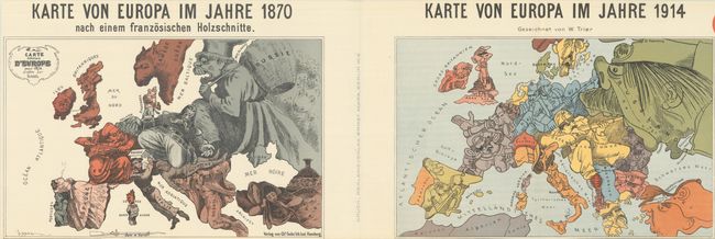
This single sheet includes two satirical maps of Europe to show the political changes from 1870 during the Franco-Prussian War to 1914 during World War I. Published by Reklameverlag Ernst Marx in Berlin.
On the left is a German edition of Paul Hadol's map from the outset of the Franco-Prussian War. Various countries and regions are represented by human and animal caricatures with props to help illustrate the situation. At the center of the conflict are France and Prussia, with France depicted as a bearded soldier attempting to thwart the advances of Prussia with a bayonet. Prussia appears as a stocky Otto von Bismarck with his hat pulled over his eyes and kneeling on Austria, a sleeping soldier, while his right hand completely covers Holland. England is shown as an enraged old woman turning her back on the mainland, with Ireland, a small bear, on a leash. The Balkans are represented by a man who is yawning and just beginning to awake. Russia is depicted as the bogey-man, trying to fill up his basket (with shadowy bear-like figures behind him). And both Spain and Turkey are shown as women, passively smoking and lounging.
On the right is Walter Trier's map created shortly after the outbreak of WWI. Trier, a German-Jewish artist, was born in Prague and emigrated to Germany to study art. After the war he became a strong anti-fascist, fleeing to England in 1936. However this map is pro-Germany, with Germany and Austria-Hungary depicted as soldiers, striking out in several directions. Belgium has already been "caught" by Germany and serves as his gun. Russia is seen as a giant, trying to swallow its neighbors. Spain sits back and watches the turmoil while France "courageously" pulls itself back. Serbia is depicted as a pig and Montenegro is a louse. Italy looks frightened with his hands in his pockets. Romania is depicted as Carol I, who ruled until his death on October 10, 1914.
The first edition of this sheet was published in 1914 and included text below the maps describing the countries and their role in the war at the time. This 1915 edition eliminates this text to fit a smaller format, also cropping out a Red Cross emblem at top right, of which just a sliver remains.
These political cartoon maps are now quite scarce, due to their ephemeral nature.
References:
Condition: A+
A clean and bright example, issued folding with staple holes along the centerfold.