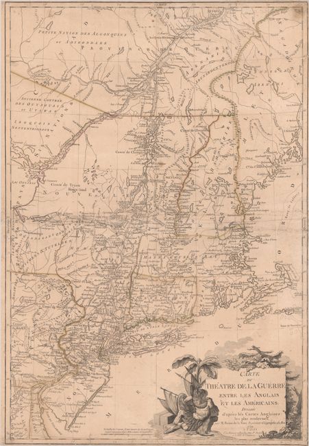
Subject: Colonial New England United States
Period: 1779 (dated)
Publication:
Color: Hand Color
Size:
20.4 x 29.7 inches
51.8 x 75.4 cm
This is an important French map of the northern American colonies during the American Revolutionary War. The map is based on Jefferys' map of the region and extends from Quebec to Cape May, NJ, and from the Kennebec River to Lake Ontario. Of key importance on this map is the depiction of the location of British troops at Saratoga in New York. The battles of Saratoga on September 19 and October 7, 1777 were critical in convincing the French to officially enter the war in support of the Continentals. Prior to the Treaty of Amity and Commerce and the Treaty of Alliance signed in Paris on February 6, 1778, the French had been secretly supporting the Continental Army with guns, ammunition, money, and other assistance in order to weaken its greatest enemy - the British Army. But King Louis XVI was reluctant to formally enter the war and suffer another potential defeat against the British (such as with the recent Seven Years' War) until the Continental Army could prove that they were capable of resisting the British on the battlefield. The battles of Saratoga, and Benjamin Franklin's negotiating skills, succeeded in garnering the allegiance of the French, which became the turning point in the war.
This map was first published in 1777 prior to the battles at Saratoga. For the 1778 edition, the troop locations were added at Saratoga, as well as at Frank-Fort and German Town in Pennsylvania from the October 4, 1777 battle. Thus this map was created for a French audience to depict the theater of war and the reason behind France's decision to enter the war.
The map also provides excellent detail of boundaries, counties, towns and cities, roads, and Indian nations. Numerous forts critical during the war are also shown, such as Fort Washington in northern Manhattan, Fort Ticonderoga on Lake Champlain, and others along the Delaware River and in northern Massachusetts. A large title cartouche fills the Atlantic Ocean (here Mer du Nord) and features a Native American chief. This map was separately published by Jacques Esnauts and Michel Rapilly.
References: McCorkle #777.6; Nebenzahl (Biblio) #121; Sellers & Van Ee #728.
Condition: B
Contemporary outline color on a lightly toned sheet with a large coat of arms watermark. There is light toning and soiling, as well as some extraneous creasing. There are archival repairs to some short edge tears and small holes in the corners of the sheet. Trimmed close to neatline at top, right and bottom.