Subject: Iceland
Period: 1844 (dated)
Publication:
Color: Hand Color
Size:
44.8 x 33.4 inches
113.8 x 84.8 cm
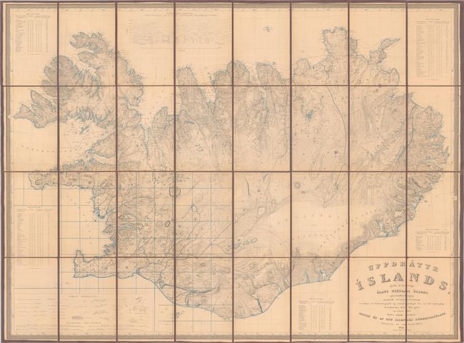
This is the first edition of the first accurate topographical map of Iceland, dated 1844 but completed in 1848. The map was designed by Olaf Nikolas Olsen, a cartographer and officer of the Danish Army. It is based on the comprehensive 12-year survey conducted by Icelandic mathematician and cartographer Bjorn Gunnlaugsson. Sponsored by the Literary Society of Iceland and the Danish government, Gunnlaugsson spent the summers from 1831 to 1843 surveying the country with just one assistant. In the winters, he would draw the maps. When his survey was complete, the hand-drawn maps were sent to Olsen in Copenhagen, who then completed the map on a scale of 1:480,000. Gunnlaugsson's survey served as the primary source for maps of the island for the next century. The map is incredibly detailed with a legend that identifies borders, roads, cities, commerce areas, lava beds, sandy areas, swamp, bodies of water, meadows and pastures, mountains, glaciers, and much more. A table at top compares the elevations of various mountains, and 5 additional tables around the map provide more information. Text on map is in Icelandic. Engraved by F.C. Holm. Originally published on 4 sheets, this example has been dissected and backed with linen.
References: cf. Rumsey #11236.
Condition: B+
Dissected and backed with linen. There is light toning and minor soiling.