Showing Featured Lots(remove filter)
Showing results for:Auction 183
Catalog Archive
64 lots
Page 1 of 2
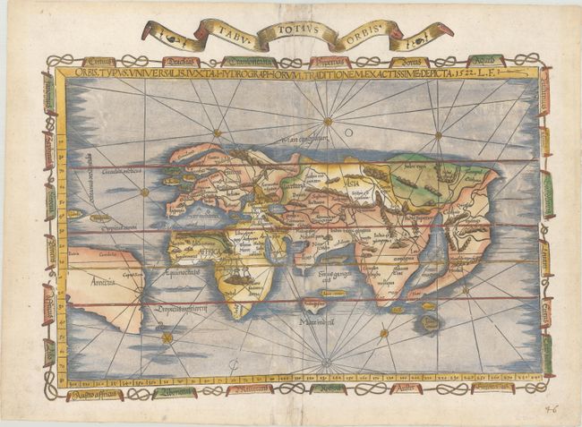
Auction 183, Lot 1
Subject: World
Fries, Lorenz
Orbis Typus Universalis Iuxta Hydrographorum Traditionem Exactissime Depicta, 1522
Size: 18.8 x 13.8 inches (47.8 x 35.1 cm)
Estimate: $6,000 - $7,500
One of the First Ptolemaic Maps to Name America
Sold for: $7,500
Closed on 6/9/2021
Auction 183, Lot 2
Subject: World
Bordone, Benedetto
[Untitled - World], 1528
Size: 15.1 x 8.4 inches (38.4 x 21.3 cm)
Estimate: $3,500 - $4,250
One of the Earliest World Maps on an Oval Projection
Sold for: $2,350
Closed on 6/9/2021
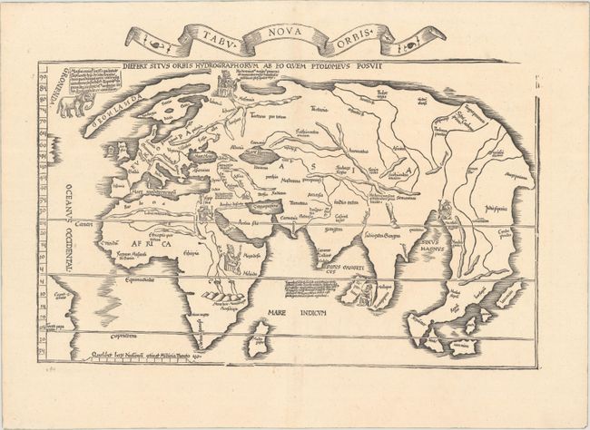
Auction 183, Lot 3
Subject: World
Fries, Lorenz
Tabu Nova Orbis, 1535
Size: 18.1 x 12.4 inches (46 x 31.5 cm)
Estimate: $4,000 - $5,000
"Modern" World Map with Portraits of Five Kings
Sold for: $3,000
Closed on 6/9/2021
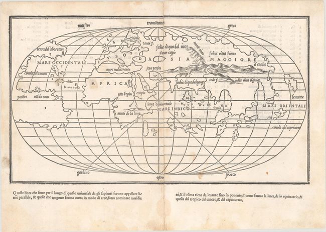
Auction 183, Lot 4
Subject: World
Honter, Jon Coronensis
Universalis Cosmographia, 1546
Size: 6.4 x 4.8 inches (16.3 x 12.2 cm)
Estimate: $1,200 - $1,500
Honter's Heart-Shaped Map of the World
Sold for: $900
Closed on 6/9/2021
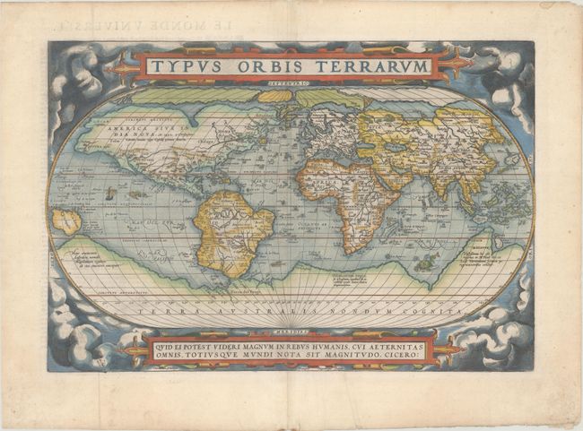
Auction 183, Lot 7
Subject: World
Ortelius, Abraham
Typus Orbis Terrarum, 1581
Size: 19.6 x 13.3 inches (49.8 x 33.8 cm)
Estimate: $7,000 - $8,500
Ortelius' Famous World Map - First Plate
Sold for: $6,000
Closed on 6/9/2021
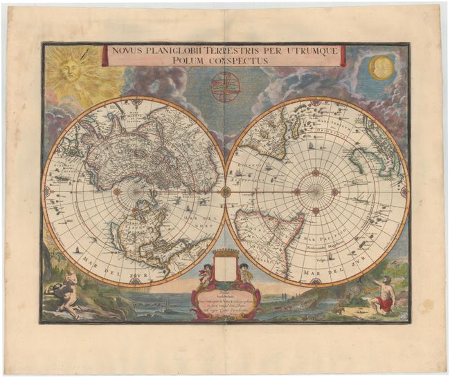
Auction 183, Lot 13
Subject: World
Blaeu/Valck
Novus Planiglobii Terrestris per Utrumque Polum Conspectus, 1695
Size: 21.1 x 15.9 inches (53.6 x 40.4 cm)
Estimate: $5,500 - $6,500
Superb World Map on a Polar Projection
Sold for: $4,000
Closed on 6/9/2021

Auction 183, Lot 28
Subject: North Pole
Hondius, Henricus
Poli Arctici, et Circumiacentium Terrarum Descriptio Novissima, 1637
Size: 19.4 x 17 inches (49.3 x 43.2 cm)
Estimate: $1,900 - $2,200
Magnificent Polar Map Surrounded by Whaling Scenes
Sold for: $1,400
Closed on 6/9/2021
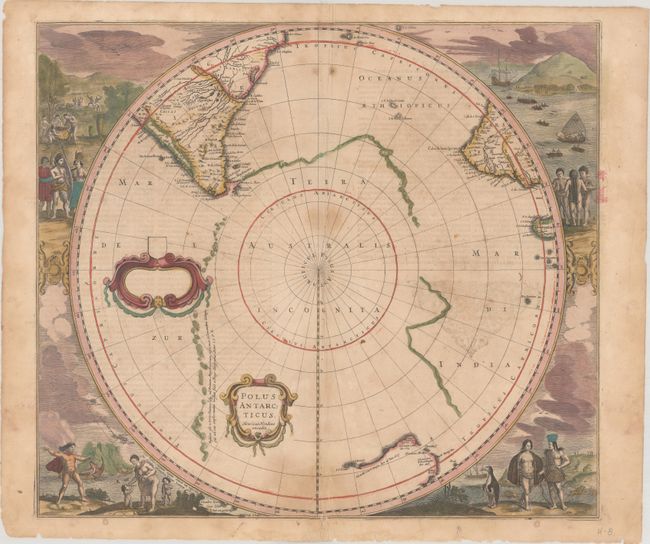
Auction 183, Lot 29
Subject: South Pole
Hondius, Henricus
Polus Antarcticus, 1639
Size: 19.5 x 17.2 inches (49.5 x 43.7 cm)
Estimate: $1,400 - $1,700
Magnificent Early Map of the South Pole in Full Contemporary Color
Sold for: $925
Closed on 6/9/2021
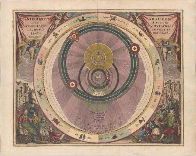
Auction 183, Lot 32
Subject: Solar System
Cellarius/Schenk & Valck
Planisphaerium Braheum, sive Structura Mundi Totius, ex Hypothesi Tychonis Brahei in Plano Delineata, 1708
Size: 19.7 x 15.8 inches (50 x 40.1 cm)
Estimate: $1,600 - $1,900
Chart Depicting Tycho Brahe's Model of the Universe
Sold for: $2,300
Closed on 6/9/2021
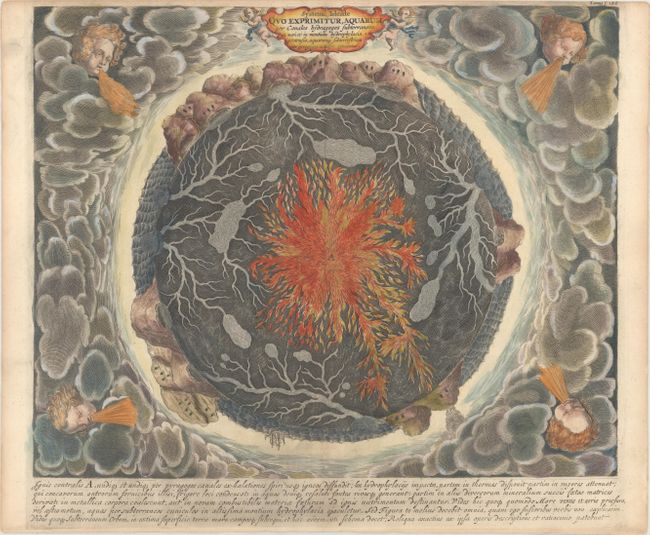
Auction 183, Lot 35
Subject: Cartographic Miscellany, Earth
Kircher, Athanasius
Systema Ideale quo Exprimitur, Aquarum per Canales Hydragogos Subterraneos ex Mari et in Montium Hydrophylacia Protrusio..., 1682
Size: 15.9 x 12.9 inches (40.4 x 32.8 cm)
Estimate: $1,600 - $1,900
Fascinating Cross-Section of the Earth
Sold for: $1,500
Closed on 6/9/2021
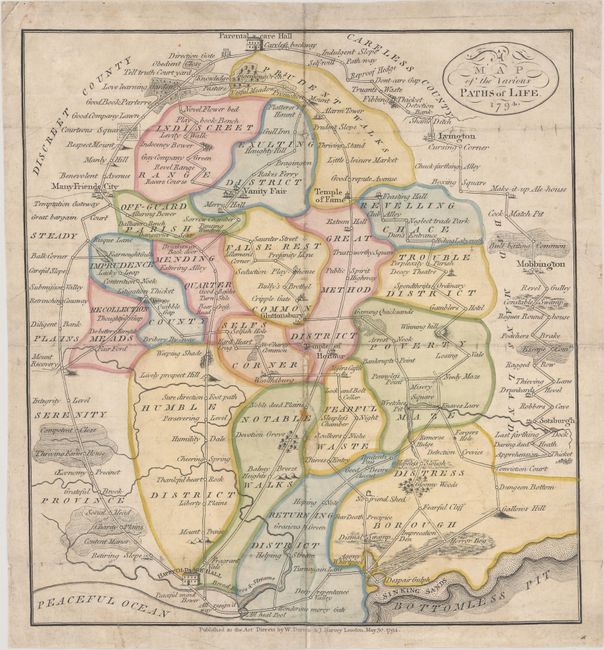
Auction 183, Lot 40
Subject: Cartographic Miscellany, Fictional Map
Darton, W. and Harvey, J.
A Map of the Various Paths of Life, 1794
Size: 11.2 x 12 inches (28.4 x 30.5 cm)
Estimate: $1,200 - $1,500
Rare Quaker Morality Map
Sold for: $850
Closed on 6/9/2021
Auction 183, Lot 45
Subject: Western Hemisphere - America, Atlantic Ocean
Waldseemuller/Fries
[Title on Verso] Tabula Terrae Novae, 1541
Size: 16.6 x 11.3 inches (42.2 x 28.7 cm)
Estimate: $9,000 - $11,000
The Waldseemuller/Fries "Admiral's Map"
Sold for: $7,000
Closed on 6/9/2021
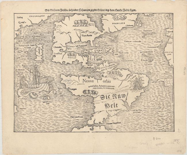
Auction 183, Lot 46
Subject: Western Hemisphere - America
Munster, Sebastian
Die Neuwen Inseln /so Hinder Hispanien Gegen Orient /bey dem Landt Indie Ligen , 1574
Size: 13.6 x 10.1 inches (34.5 x 25.7 cm)
Estimate: $5,500 - $6,500
One of the Most Important 16th Century Maps of the New World
Sold for: $3,900
Closed on 6/9/2021
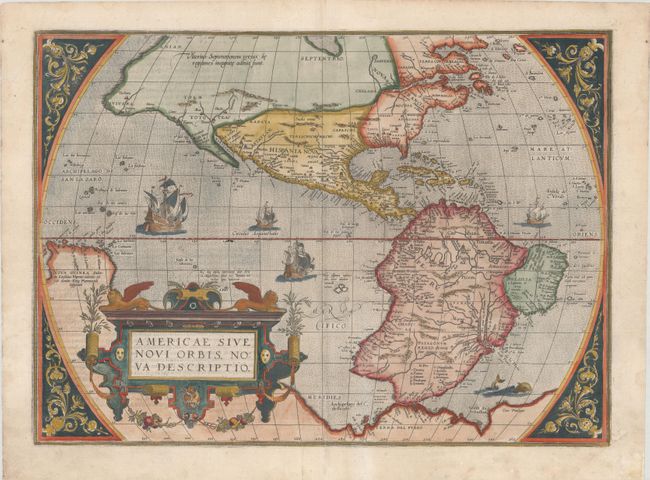
Auction 183, Lot 47
Subject: Western Hemisphere - America
Ortelius, Abraham
Americae sive Novi Orbis, Nova Descriptio, 1581
Size: 19.8 x 14.3 inches (50.3 x 36.3 cm)
Estimate: $5,500 - $6,500
Ortelius' Influential Map of the New World - Second Plate
Sold for: $4,250
Closed on 6/9/2021
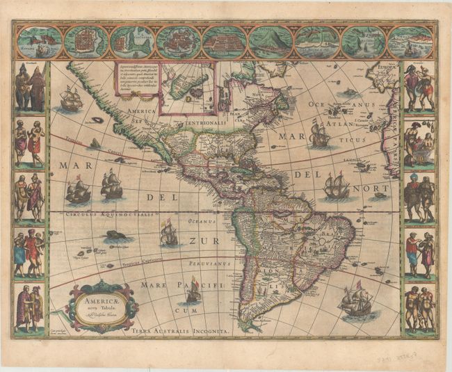
Auction 183, Lot 49
Subject: Western Hemisphere - America
Hondius, Jodocus
America, 1623
Size: 19.7 x 14.7 inches (50 x 37.3 cm)
Estimate: $3,250 - $4,000
Hondius' Important Map of the Americas
Sold for: $2,400
Closed on 6/9/2021
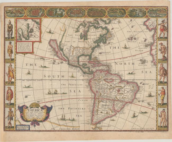
Auction 183, Lot 50
Subject: Western Hemisphere - America
Speed, John
America with Those Known Parts in That Unknowne Worlde Both People and Manner of Buildings , 1626
Size: 20.4 x 15.6 inches (51.8 x 39.6 cm)
Estimate: $4,750 - $6,000
Speed's Popular Carte-a-Figures Map of the Americas
Sold for: $4,750
Closed on 6/9/2021
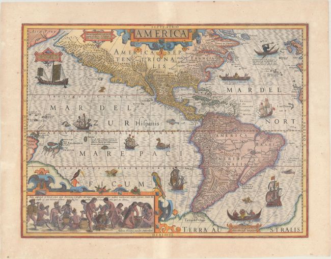
Auction 183, Lot 51
Subject: Western Hemisphere - America
Blaeu, Willem
Americae Nova Tabula, 1631
Size: 21.6 x 16.1 inches (54.9 x 40.9 cm)
Estimate: $5,000 - $6,000
Early Edition of Blaeu's Stunning Carte-a-Figures Map of the Americas in Full Contemporary Color
Sold for: $3,750
Closed on 6/9/2021
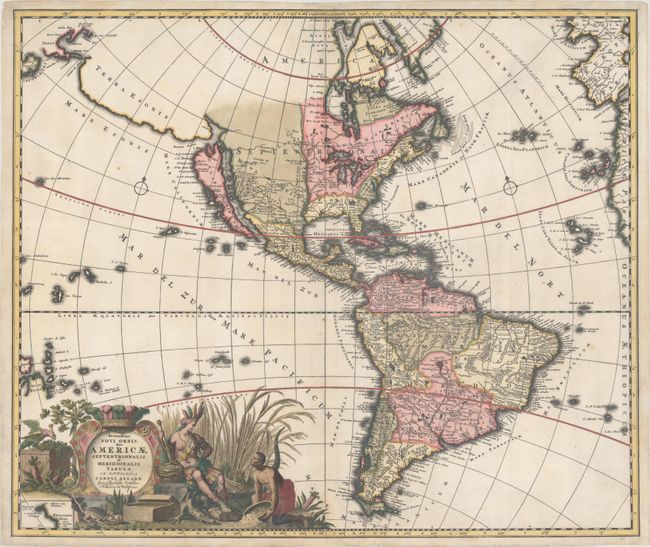
Auction 183, Lot 52
Subject: Western Hemisphere - America
Allard, Carel
Recentissima Novi Orbis, sive Americae Septentrionalis et Meridionalis Tabula, 1697
Size: 23.2 x 19.6 inches (58.9 x 49.8 cm)
Estimate: $1,800 - $2,100
Allard's Elaborate Map of the Western Hemisphere
Sold for: $1,400
Closed on 6/9/2021
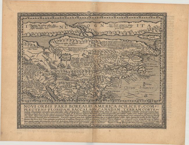
Auction 183, Lot 59
Subject: Colonial North America
Quad, Matthias von Kinckelbach
Novi Orbis Pars Borealis, America Scilicet, Complectens Floridam, Baccalaon, Canadam, Terram Corterialem, Virginiam..., 1600
Size: 11.5 x 8.9 inches (29.2 x 22.6 cm)
Estimate: $2,750 - $3,500
One of the Earliest Maps Devoted to North America
Sold for: $1,800
Closed on 6/9/2021
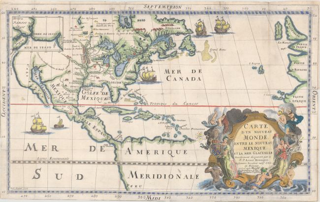
Auction 183, Lot 60
Subject: Colonial North America
Hennepin, Louis de (Fr.)
Carte d'un Nouveau Monde, Entre le Nouveau Mexique, et la Mer Glacialle, 1698
Size: 18.4 x 11.5 inches (46.7 x 29.2 cm)
Estimate: $2,500 - $3,250
Hennepin's Important, Updated Map of North America
Sold for: $3,250
Closed on 6/9/2021
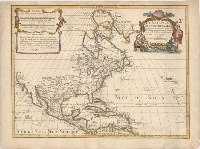
Auction 183, Lot 61
Subject: Colonial North America
Delisle, Guillaume
L'Amerique Septentrionale. Dressee sur les Observations de Mrs. de l'Academie Royale des Sciences. & Quelques Autres, & sur les Memoires les Plus Recens, 1700
Size: 23.8 x 17.9 inches (60.5 x 45.5 cm)
Estimate: $1,600 - $1,900
Delisle's Foundation Map of North America
Sold for: $1,100
Closed on 6/9/2021
Auction 183, Lot 71
Subject: Colonial Eastern North America & West Indies
Delisle, Guillaume
Carte du Mexique et de la Floride des Terres Angloises et des Isles Antilles du Cours et des Environs de la Riviere de Mississipi..., 1703
Size: 25.3 x 18.6 inches (64.3 x 47.2 cm)
Estimate: $3,000 - $3,750
Landmark in American Cartography - First Printed Map to Accurately Depict the Mouth of the Mississippi River
Sold for: $2,200
Closed on 6/9/2021
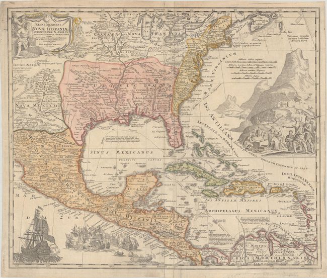
Auction 183, Lot 72
Subject: Colonial Eastern North America & West Indies
Homann, Johann Baptist
Regni Mexicani seu Novae Hispaniae Ludovicianae, N. Angliae, Carolinae, Virginiae et Pensylvaniae nec non Insularum Archipelagi Mexicani in America Septentrionali Accurata Tabula, 1720
Size: 22.1 x 18.6 inches (56.1 x 47.2 cm)
Estimate: $1,600 - $1,900
Homann's Decorative Map of Colonial America in the Era of the War of the Spanish Succession
Sold for: $1,500
Closed on 6/9/2021
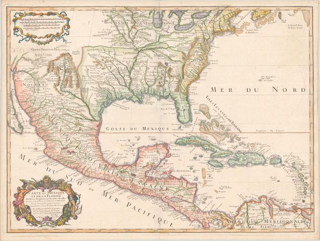
Auction 183, Lot 73
Subject: Colonial Eastern North America & West Indies
Popple/Covens & Mortier
A Map of the British Empire in America with the French, Spanish and Hollandish Settlements Adjacent Thereto by Henry Popple, 1741
Size: 18.9 x 19.3 inches (48 x 49 cm)
Estimate: $3,000 - $3,750
Index Sheet of Popple's Map
Sold for: $2,200
Closed on 6/9/2021
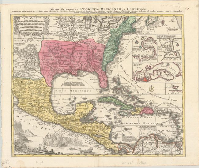
Auction 183, Lot 74
Subject: Colonial Eastern North America & West Indies
Lotter, Tobias Conrad
Mappa Geographica Regionem Mexicanam et Floridam Terrasque Adjacentes, ut et Anteriores Americae Insulas, Cursus Itidem et Reditus Navigantium Versus Flumen Missisipi..., 1760
Size: 22.4 x 18.5 inches (56.9 x 47 cm)
Estimate: $1,200 - $1,500
Lotter's Version of Delisle's Important Map
Sold for: $750
Closed on 6/9/2021
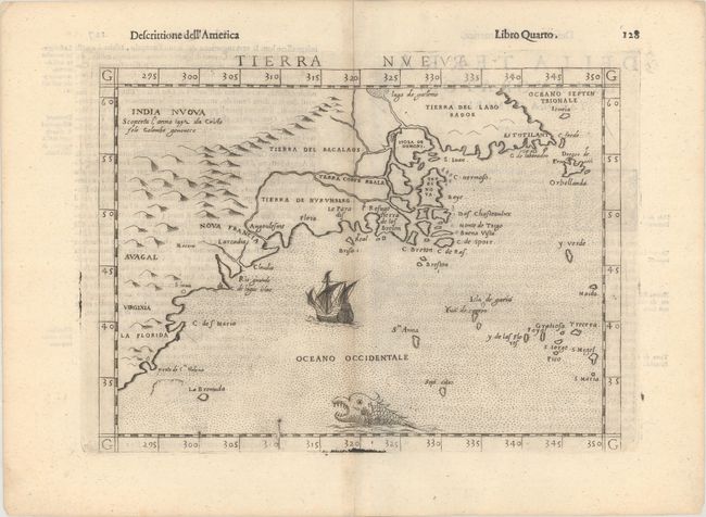
Auction 183, Lot 84
Subject: Eastern United States & Canada
Ruscelli, Girolamo
Tierra Nueva, 1598
Size: 9.6 x 7 inches (24.4 x 17.8 cm)
Estimate: $1,100 - $1,400
Ruscelli's Map of the East Coast
Sold for: $850
Closed on 6/9/2021
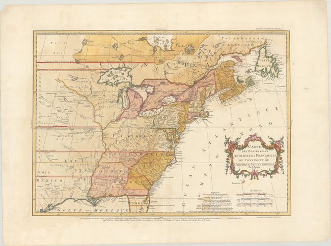
Auction 183, Lot 86
Subject: Colonial Eastern United States & Canada
Palairet, Jean
Carte des Possessions Angloises & Francoises du Continent de l'Amerique Septentrionale, 1756
Size: 22.8 x 16.3 inches (57.9 x 41.4 cm)
Estimate: $2,200 - $2,500
Important Map of French and English Territorial Claims at the Outset of the French & Indian War
Sold for: $2,000
Closed on 6/9/2021
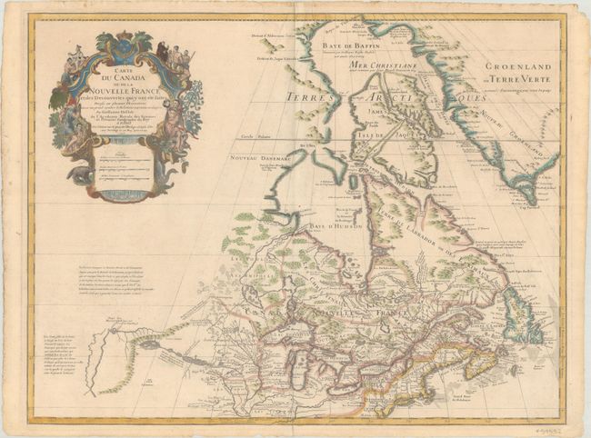
Auction 183, Lot 96
Subject: Colonial Northeastern United States & Canada, Great Lakes
Delisle, Guillaume
Carte du Canada ou de la Nouvelle France et des Decouvertes qui y ont ete Faites Dressee sur Plusieurs Observations et sur un Grand Nombre de Relations Imprimees ou Manuscrites..., 1703
Size: 25.6 x 19.6 inches (65 x 49.8 cm)
Estimate: $1,600 - $1,900
Delisle's Seminal Map of Canada and the Great Lakes
Sold for: $1,400
Closed on 6/9/2021
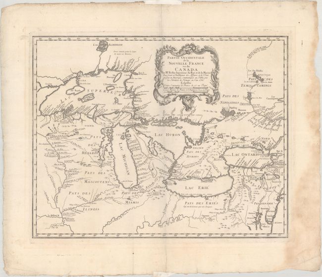
Auction 183, Lot 99
Subject: Colonial Great Lakes
Bellin/Homann Heirs
Partie Occidentale de la Nouvelle France ou du Canada, 1755
Size: 21.4 x 16.8 inches (54.4 x 42.7 cm)
Estimate: $1,400 - $1,700
Influential Map of the Great Lakes
Sold for: $1,200
Closed on 6/9/2021
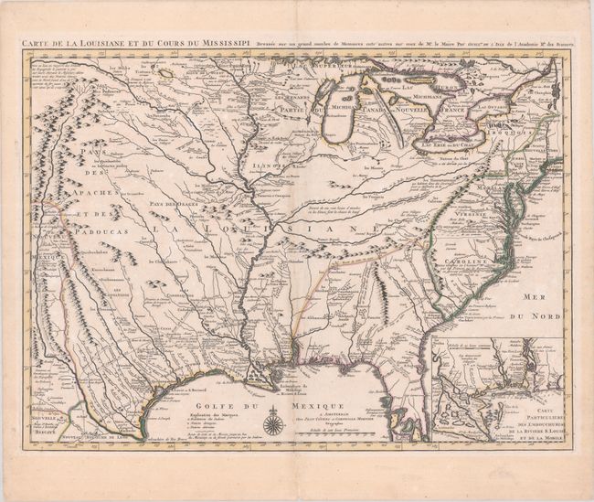
Auction 183, Lot 117
Subject: Colonial Eastern United States, Louisiana Territory
Delisle/Covens & Mortier
Carte de la Louisiane et du Cours du Mississipi Dressee sur un Grand Nombre de Memoires Entr' Autres sur ceux de Mr. le Maire, 1730
Size: 23.6 x 17.3 inches (59.9 x 43.9 cm)
Estimate: $1,900 - $2,200
Delisle's Influential Map of the Louisiana Territory
Sold for: $2,000
Closed on 6/9/2021
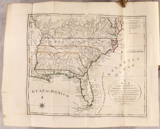
Auction 183, Lot 118
Subject: Eastern United States, Franklin
Morse, Jedidiah (Rev.)
[2 Maps in Book] A Map of the States of Virginia, North Carolina, South Carolina and Georgia; Comprehending the Spanish Provinces of East and West Florida... [and] A Map of the Northern and Middle States... [bound in] The American Geography..., 1792
Size: 14.4 x 12.4 inches (36.6 x 31.5 cm)
Estimate: $1,200 - $1,500
Includes Purcell's Map Locating the Proposed State of Franklin
Sold for: $1,600
Closed on 6/9/2021
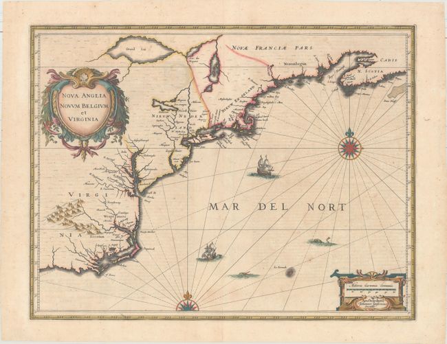
Auction 183, Lot 130
Subject: Colonial New England & Mid-Atlantic United States
Jansson, Jan
Nova Anglia Novum Belgium et Virginia, 1639
Size: 19.9 x 15.3 inches (50.5 x 38.9 cm)
Estimate: $1,400 - $1,700
Jansson's Influential Map of the East Coast
Unsold
Closed on 6/9/2021
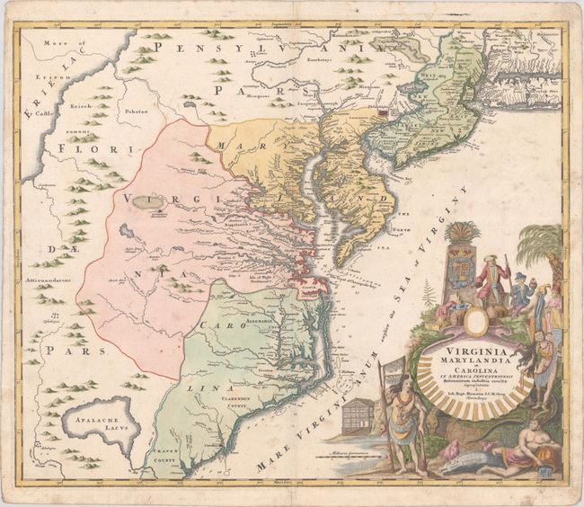
Auction 183, Lot 135
Subject: Colonial Mid-Atlantic United States
Homann, Johann Baptist
Virginia Marylandia et Carolina in America Septentrionali Britannorum Industria Excultae Repraesentatae, 1730
Size: 22.8 x 19.1 inches (57.9 x 48.5 cm)
Estimate: $1,500 - $1,800
Map Created to Promote German Immigration to the New World
Sold for: $1,000
Closed on 6/9/2021
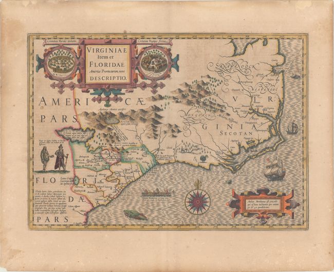
Auction 183, Lot 139
Subject: Colonial Southeast United States
Hondius, Jodocus
Virginiae Item et Floridae Americae Provinciarum, Nova Descriptio, 1619
Size: 19.3 x 13.6 inches (49 x 34.5 cm)
Estimate: $1,800 - $2,100
A Seminal Map of the Southeast and Early American Cartography - Full Contemporary Color
Sold for: $1,300
Closed on 6/9/2021
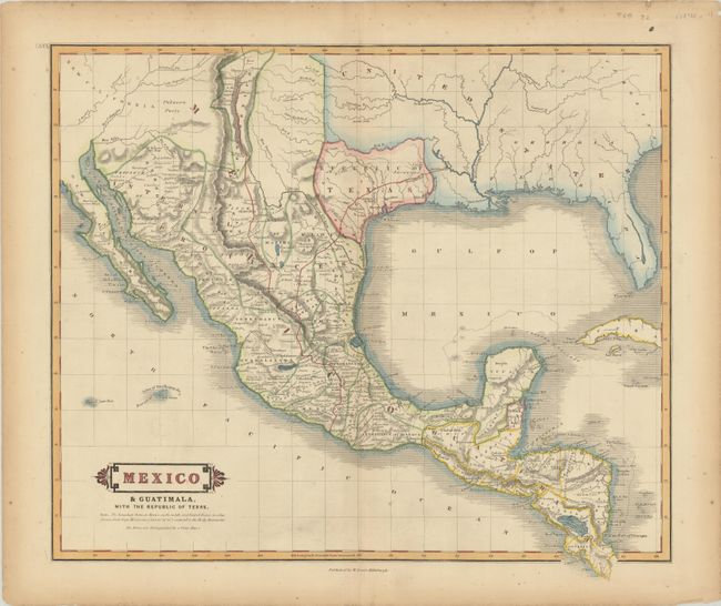
Auction 183, Lot 248
Subject: Southern United States, Mexico & Central America, Texas
Lizars, William Home
Mexico & Guatimala, with the Republic of Texas, 1838
Size: 19.2 x 16.6 inches (48.8 x 42.2 cm)
Estimate: $1,100 - $1,400
One of the Few Maps to Include "Republic" in the Title
Sold for: $850
Closed on 6/9/2021
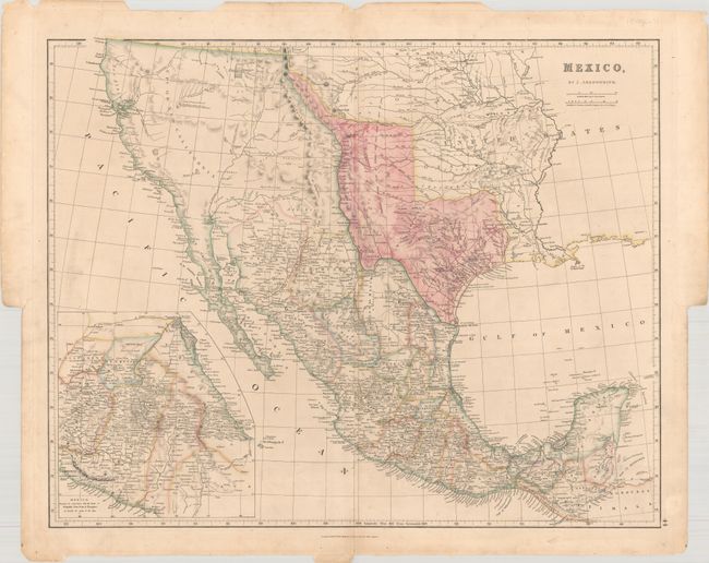
Auction 183, Lot 253
Subject: Southwestern United States & Mexico, Texas
Arrowsmith, John
Mexico, 1842
Size: 23.6 x 18.9 inches (59.9 x 48 cm)
Estimate: $1,600 - $1,900
Features the Republic of Texas in its Largest Configuration
Sold for: $1,200
Closed on 6/9/2021
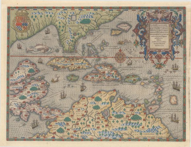
Auction 183, Lot 260
Subject: Gulf of Mexico & Caribbean
Bry, Theodore de
Occidentalis Americae Partis, vel, Earum Regionum quas Christophorus Columbus Primu Detexit Tabula Chorographicae Multorum Auctorum Scriptis..., 1594
Size: 17.1 x 12.9 inches (43.4 x 32.8 cm)
Estimate: $7,500 - $9,000
De Bry's Superb Map of the Southeastern US, Caribbean & Northern South America
Sold for: $5,500
Closed on 6/9/2021
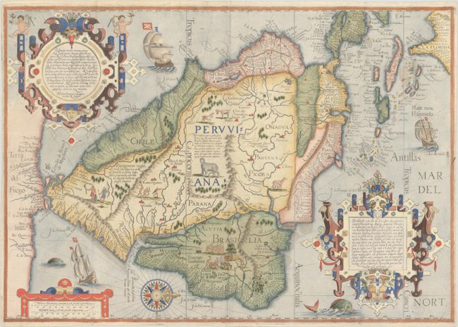
Auction 183, Lot 268
Subject: South America & Caribbean
Linschoten/Langren
Delineatio Omnium Orarum Totius Australis Partis Americae, Dictae Peruvianae, a R. de la Plata, Brasiliam, Pariam, & Castellam Auream..., 1596
Size: 21.8 x 15.3 inches (55.4 x 38.9 cm)
Estimate: $7,000 - $8,500
One of the Most Decorative Early Maps of South America
Sold for: $5,500
Closed on 6/9/2021
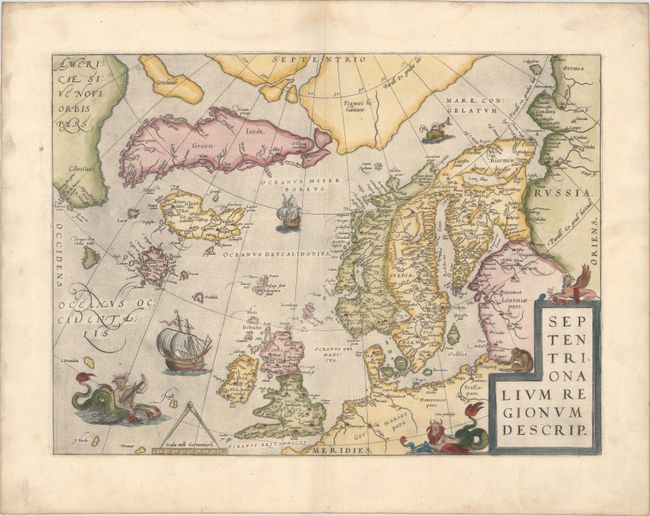
Auction 183, Lot 309
Subject: Arctic & Scandinavia
Ortelius, Abraham
Septentrionalium Regionum Descrip., 1570
Size: 19.3 x 14.3 inches (49 x 36.3 cm)
Estimate: $2,400 - $3,000
Early Example of Ortelius' Map of the Arctic with Mythical Islands
Sold for: $1,700
Closed on 6/9/2021
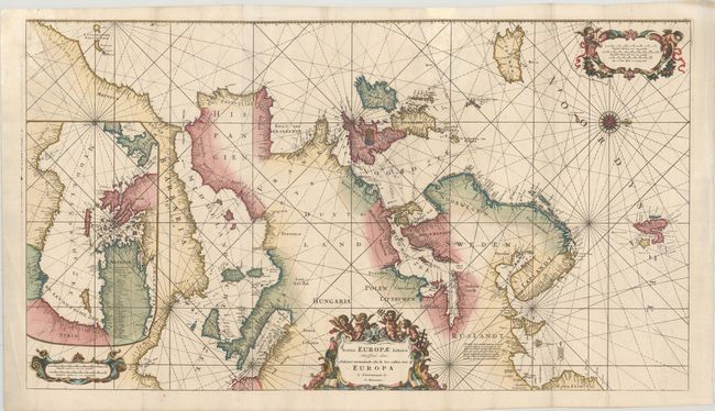
Auction 183, Lot 316
Subject: Europe
Renard/De Wit
Totius Europae Littora Novissime Edita. Pascaert Vertoonende Alle de See-Custen van Europa, 1715
Size: 34.3 x 19.3 inches (87.1 x 49 cm)
Estimate: $5,500 - $7,000
Decorative Sea Chart of Europe with Greenland
Unsold
Closed on 6/9/2021
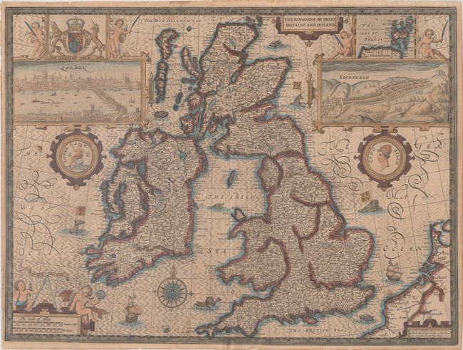
Auction 183, Lot 322
Subject: Britain
Speed, John
The Kingdome of Great Britaine and Ireland, 1610
Size: 20.1 x 15 inches (51.1 x 38.1 cm)
Estimate: $2,400 - $3,000
Speed's Famous Map of the British Isles Engraved by Hondius
Sold for: $1,500
Closed on 6/9/2021
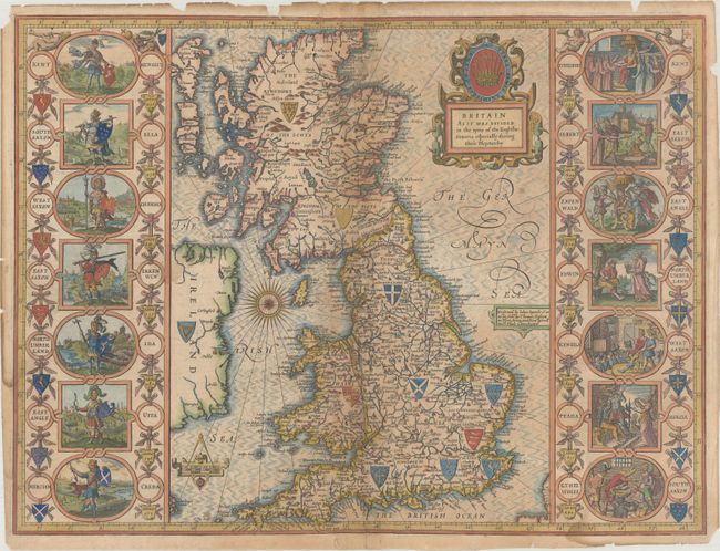
Auction 183, Lot 328
Subject: Britain
Speed, John
Britain as It Was Devided in the Tyme of the Englishe-Saxons Especially During Their Heptarchy, 1676
Size: 20 x 15 inches (50.8 x 38.1 cm)
Estimate: $2,000 - $2,300
Speed's "Heptarchy" Map Depicting the Saxon Kingdoms
Sold for: $1,200
Closed on 6/9/2021
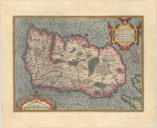
Auction 183, Lot 343
Subject: Ireland
Ortelius, Abraham
Eryn. Hiberniae, Britannicae Insulae, Nova Descriptio. Irlandt, 1598
Size: 18.7 x 13.8 inches (47.5 x 35.1 cm)
Estimate: $1,400 - $1,700
Ortelius' First Map of Ireland
Sold for: $1,400
Closed on 6/9/2021
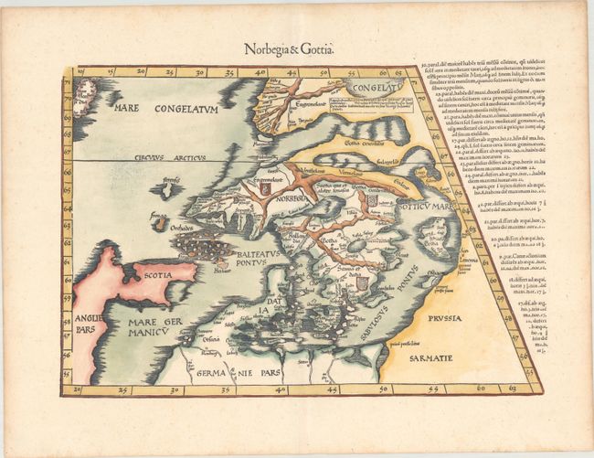
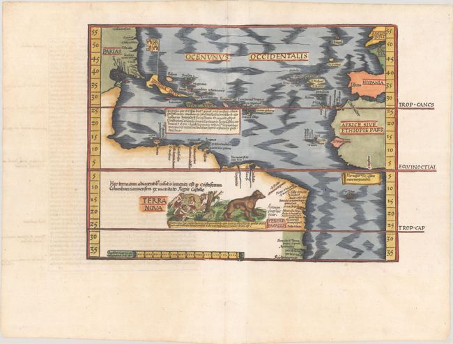
Auction 183, Lot 345
Subject: Scandinavia
Ptolemy/Fries
Norbegia & Gottia, 1541
Size: 17.8 x 12.1 inches (45.2 x 30.7 cm)
Estimate: $2,300 - $2,750
Uncommon Early Map of Scandinavia
Sold for: $1,700
Closed on 6/9/2021
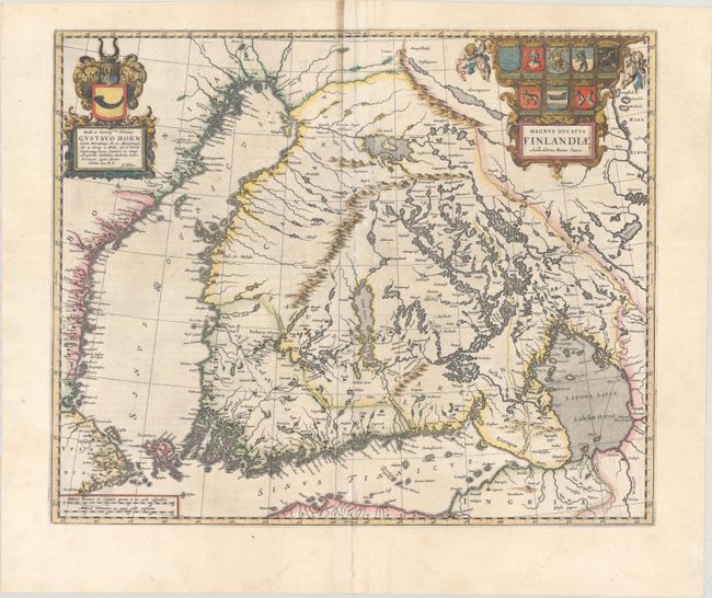
Auction 183, Lot 350
Subject: Finland
Blaeu, Johannes
Magnus Ducatus Finlandiae Auct. Andrea Buraeo Sueco, 1659
Size: 20.6 x 17 inches (52.3 x 43.2 cm)
Estimate: $1,400 - $1,700
The First Separately Published Map of Finland
Unsold
Closed on 6/9/2021
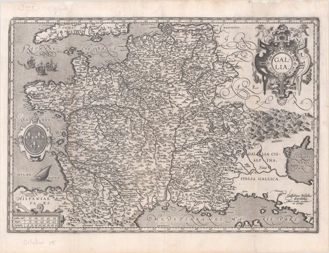
Auction 183, Lot 373
Subject: France
Ortelius, Abraham
Gallia, 1588
Size: 19.8 x 13.7 inches (50.3 x 34.8 cm)
Estimate: $6,000 - $8,000
A Nearly Unattainable Ortelius Map With only a Handful of Surviving Copies
Unsold
Closed on 6/9/2021
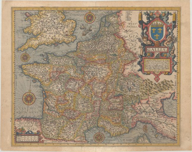
Auction 183, Lot 374
Subject: France
Vrients, Jan Baptista
Gallia, 1609
Size: 18.9 x 15.7 inches (48 x 39.9 cm)
Estimate: $750 - $900
Unsold
Closed on 6/9/2021
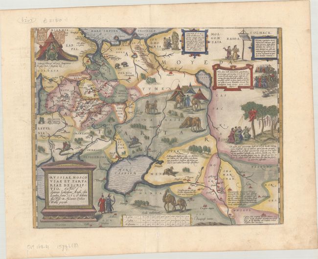
Auction 183, Lot 409
Subject: Russia, Eastern Europe & Central Asia
Ortelius, Abraham
Russiae, Moscoviae et Tartariae Descriptio. Auctore Antonio Ienkensono Anglo, Edita Londini Anno 1562..., 1579
Size: 17.5 x 13.8 inches (44.5 x 35.1 cm)
Estimate: $2,000 - $2,300
Ortelius' Map of Russia with a Vignette of Ivan the Terrible
Sold for: $1,500
Closed on 6/9/2021
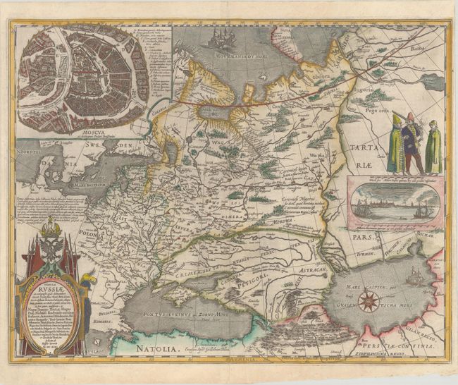
Auction 183, Lot 410
Subject: Russia in Europe
Blaeu, Willem
Tabula Russiae ex Autographo, quod Delineandum Curavit Foedor Filius Tzaris Boris Desumta ... M.DC.XIIII, 1643
Size: 21.6 x 16.8 inches (54.9 x 42.7 cm)
Estimate: $1,800 - $2,100
Blaeu's Decorative Map of Russia
Sold for: $1,700
Closed on 6/9/2021
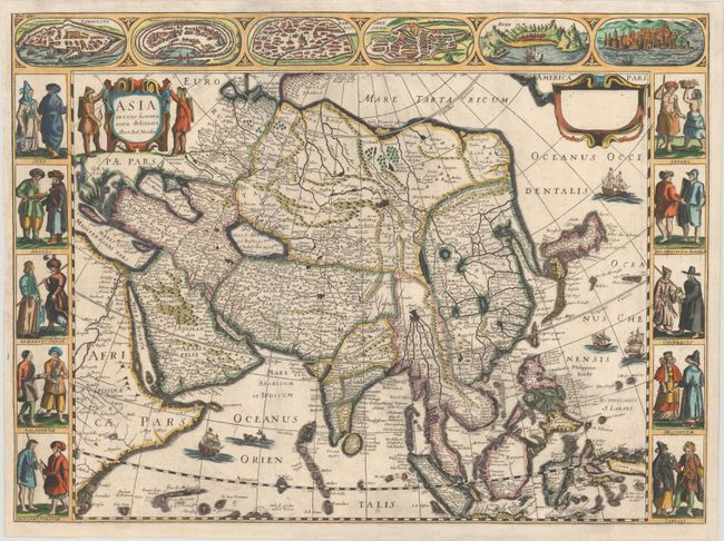
Auction 183, Lot 475
Subject: Asia
Picart, Nicolas
Asia Recens Summa Cura Delineata, 1659
Size: 21.7 x 16 inches (55.1 x 40.6 cm)
Estimate: $2,750 - $3,500
Scarce Derivative of Hondius' Carte-a-Figures Map of Asia
Sold for: $1,800
Closed on 6/9/2021
64 lots
Page 1 of 2