Subject: Colonial Eastern United States & Canada
Period: 1756 (dated)
Publication: Atlas Methodique...
Color: Hand Color
Size:
22.8 x 16.3 inches
57.9 x 41.4 cm
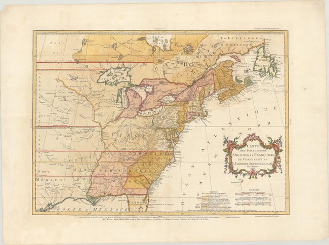
This is one of the best maps of the colonies at the outset of the French and Indian War. Palairet was the Agent to the States-General in London. In 1755 he published his map with a pamphlet "A Concise Description of the English and French Possessions in North-America" and in atlas format the same year, distributed in London, Amsterdam, Berlin, and The Hague. The map was beautifully engraved by Thomas Kitchen and intricately colored to show the disputed lands, forts, roads, and the extent of settlement in the region. The coloring indicates British possessions, French possessions, and disputed regions, and the chain of forts being built by the French to encircle the British colonies are shown by small symbols. This is the second state as identified by McCorkle with both French and English text. However, more recently Ashley Baynton-Williams and Barry Ruderman have identified 5 states of this map, this being the fourth state with the date changed to 1756, Palairet's name added to the title cartouche, and the note adjacent to the boundary line in Florida reads "Limites suivant la Chartre du Roi Charles II."
This map was based on John Mitchell's index of his large, epic map of the region, A Map of the British Colonies in North America published in 1755. Geographically, the map depicts the borders of the colonies extending well past the Mississippi River to the western reaches of the map. The Great Lakes are beautifully illustrated with Lake Superior still sporting the imaginary island of Philippeaux, and the area of present-day Texas is named Nouv: Mexico, with several roads and a handful of towns, including Cenis.
The fact that this map includes elements in both French and English indicates that it was intended for wider distribution throughout Europe. Palairet was born in France but fled to England where he became a French tutor to King George II’s children. Perhaps as a result of his heritage, Palairet uses a neutral tone in both his Atlas Methodique and on this map, describing French advances as "disputed lands" rather than as "encroachments," as one would typically find on English maps of the time period. A fascinating map that illustrates the competing interests at the beginning of the French and Indian War.
References: McCorkle #755.22; Sellers and Van Ee #56; Shirley (BL Atlases) T.PAL-1a #14; Tooley (America), p. 62 #18-c.
Condition: B+
On watermarked paper with some faint staining. Several short edge tears confined to the blank margins have been closed on verso with archival tape.