Subject: Scandinavia
Period: 1541 (published)
Publication: Claudii Ptolemaei Alexandrini Geographicae…
Color: Hand Color
Size:
17.8 x 12.1 inches
45.2 x 30.7 cm
Claudius Ptolemy was a mathematician, astronomer and geographer who worked in Alexandria, then a part of the Roman Empire, in the 2nd century AD. One of the most learned and influential men of his time, his theories dominated both astronomy and geography for nearly 1500 years. His writings were kept alive by Arabic scholars during the Middle Ages and reemerged in Europe during the Renaissance. The birth of printing led to wide dissemination of his great works on astronomy and geography. There were a number of editions of his Geographia beginning in 1477. These early editions contained maps based on his original writings, known as Ptolemaic maps. As geographic knowledge increased with the explorations of Columbus, Magellan, Cabot and others, maps of the New World were added, and maps of the Old World were revised. Ptolemy's Geographia continued to be revised and published by some of the most important cartographers including Martin Waldseemuller, Sebastian Munster, Giacomo Gastaldi, Jodocus Hondius, and Gerard Mercator (whose last edition was published in 1730).
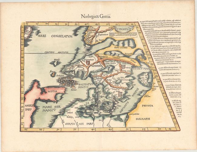
This early woodblock map of Scandinavia is a reduced-sized version of Martin Waldseemuller's map of 1513, which in turn was based on Nicolaus Germanus' map of 1482. Although the region is beginning to take shape, the depiction is more conjectural the further north it goes. Greenland appears to the north, connected to the mainland by a narrow isthmus. In true Ptolemaic fashion, Scotland is shown leaning east into the North Sea. The text to the right of the map explains the remarkable lengthening of daylight hours as one travels further north, which was more pronounced in Scandinavia than in other regions of Europe.
Although Fries' map is a close copy of Waldseemuller's, there are a few notable differences. Due to its reduced size, the map no longer extends west to include Ireland or the Hebrides archipelago. In addition, armorial shields for the Scandinavian kingdoms have been added. Prussia is also now named at bottom right. This edition was printed by Gaspar Treschel and edited by Michael Villanovus (known as Servetus). Servetus was charged with heresy by John Calvin in 1553, in part due to the text in this atlas. The courts found him guilty and sentenced him to burning at the stake, atop a pyre of his own books, including this atlas.
References: Ginsberg #6; Mickwitz & Miekkavaara #211-34.
Condition: A
A nice impression on paper with a bunch of grapes watermark and light toning along the edges of the sheet.