Subject: Colonial Eastern North America & West Indies
Period: 1703 (dated)
Publication:
Color: Hand Color
Size:
25.3 x 18.6 inches
64.3 x 47.2 cm
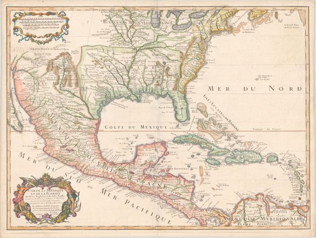
This important map is credited with accurately showing the course of the Mississippi River and its mouth for the first time. It was compiled partly from the reports of important French expeditions of La Salle, Bienville and Iberville. It is an attractive map that includes much of the present-day United States, Mexico, Central America, and the Caribbean. The map correctly shows the Great Lakes region, the English settlements along the East Coast, and the early Spanish and Indian settlements in what are now Texas and New Mexico. The early native settlement of Checagou (Chicago) is named on Lake Michigan, called Lac des Ilinois after the native tribe. The name of Checagou refers to the wild garlic that grew abundantly there. The map influenced later delineations of the Mississippi River by Seutter, Homann, Lotter and others for many years. The decorative cartouche was engraved by C. Simmoneau. This is the third state, with the author's address at "le Quai de l'Horloge" and Renard's imprint erased in the distance scale cartouche.
References: Cumming (SE) #137; Lemmon plt #16; Tooley (Amer) #50, p. 22; Wheat (TMW) pp. 58-61; Schwartz & Ehrenberg, pl. 82.
Condition: A
A crisp impression on a watermarked sheet with a few faint spots and light show-through of manuscript title at top left.