Subject: Europe
Period: 1715 (circa)
Publication: Atlas de la Navigation et du Commerce…
Color: Hand Color
Size:
34.3 x 19.3 inches
87.1 x 49 cm
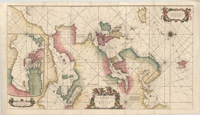
This fabulous portolan-style sea chart is oriented with west at the top. It covers the Atlantic coastlines from northwest Africa to Greenland, the Mediterranean, and the North Sea; thus covering from Iceland to Nova Zemla and from Spitzbergen to Morocco. Inset at left is a continuation chart of the Eastern Mediterranean that covers the interior of northern Africa. This chart has a long and influential publishing history. The map originated in 1675 by Frederick de Wit who compiled it from Blaeu's four-sheet chart of Europe and the Atlantic. De Wit's plates came into the possession of Louis Renard (c. 1715) who revised the chart, removed some of the decorative elements, and added a partial coastline of Greenland, which is unnamed. It then came into the hands of the Ottens brothers, who labeled Greenland and published the map again in 1739 and 1745. It is richly embellished with a beautiful compass rose, and three cartouches featuring a host of inquisitive putti. Printed on two sheets, joined as issued.
References: Shirley (BL Atlases) M.REN-1a.
Condition: B+
A crisp impression with contemporary color in the map and later color in the cartouches, on bright sheets with very minor soiling and a crease outside the image at bottom left. Issued folding and now flattened with professional repairs to several tears and chips at the top of the sheet, with a minor amount of the rhumb lines to the left of Iceland skillfully replaced in facsimile.