Showing Featured Lots(remove filter)
Showing results for:Auction 150
Catalog Archive
71 lots
Page 1 of 2
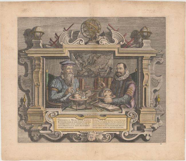
Auction 150, Lot 2
Subject: Title Pages - Portraits
Hondius
Gerardus Mercator … Iudocus Hondius …, 1635
Size: 17.7 x 15.1 inches (45 x 38.4 cm)
Estimate: $2,500 - $3,250
Famous Portraits of Mercator and Jodocus Hondius
Sold for: $1,800
Closed on 9/17/2014
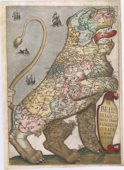
Auction 150, Lot 3
Subject: Frontispiece - Low Countries
Strada, Famiamo, S.J.
De Bello Belgico Decas Prima Famiani Stradae Rom. Soc. Iesu, 1632
Size: 8.8 x 12.5 inches (22.4 x 31.8 cm)
Estimate: $5,000 - $6,000
The Largest Strada Leo Belgicus
Unsold
Closed on 9/17/2014
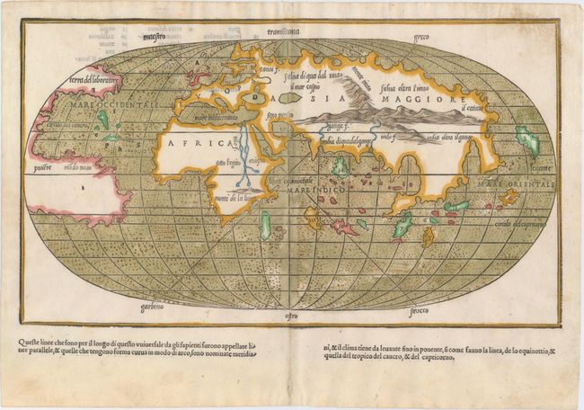
Auction 150, Lot 10
Subject: World
Bordone, Benedetto
[Untitled - World], 1528
Size: 15.1 x 8.6 inches (38.4 x 21.8 cm)
Estimate: $3,500 - $4,250
One of the Earliest World Maps on an Oval Projection
Sold for: $3,500
Closed on 9/17/2014
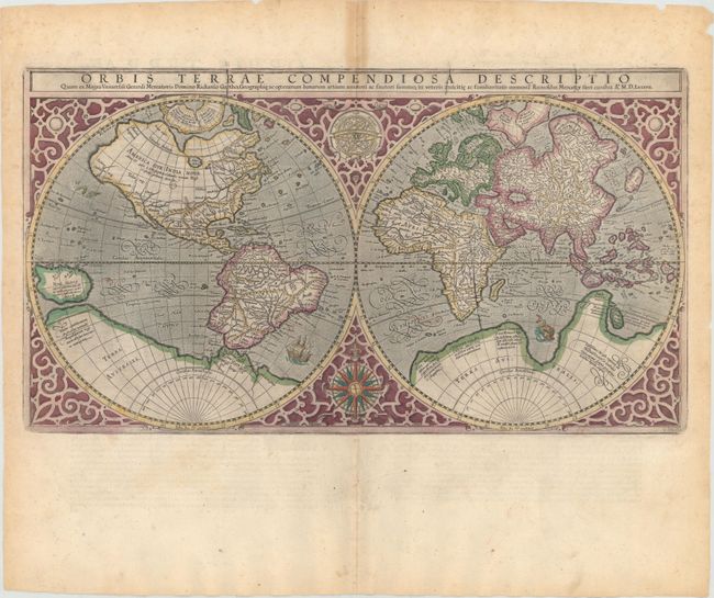
Auction 150, Lot 11
Subject: World
Mercator, Rumold
Orbis Terrae Compendiosa Descriptio..., 1587
Size: 20.6 x 11.3 inches (52.3 x 28.7 cm)
Estimate: $5,000 - $6,500
Mercator's Double-Hemisphere World Map
Unsold
Closed on 9/17/2014
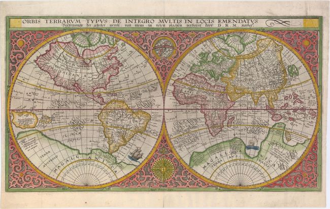
Auction 150, Lot 15
Subject: World
Plancius, Petrus
Orbis Terrarum Typus de Integro Multis in Locis Emendatus..., 1625
Size: 20.3 x 11.2 inches (51.6 x 28.4 cm)
Estimate: $3,250 - $4,000
Plancius' World Map Surrounded by Elegant Strapwork
Unsold
Closed on 9/17/2014
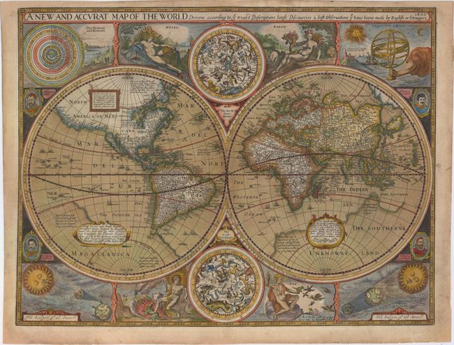
Auction 150, Lot 16
Subject: World
Speed, John
A New and Accurat Map of the World Drawne According to ye Truest Descriptions Latest Discoveries & Best Observations yt Have Beene Made by English or Strangers, 1626
Size: 20.4 x 15.5 inches (51.8 x 39.4 cm)
Estimate: $14,000 - $16,000
Speed's Double-Hemisphere World Map
Sold for: $12,500
Closed on 9/17/2014
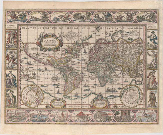
Auction 150, Lot 17
Subject: World
Blaeu, Willem
Nova Totius Terrarum Orbis Geographica ac Hydrographica Tabula, 1635
Size: 21.4 x 16.1 inches (54.4 x 40.9 cm)
Estimate: $14,000 - $16,000
Blaeu's Magnificent Carte-a-Figures World Map
Sold for: $10,000
Closed on 9/17/2014
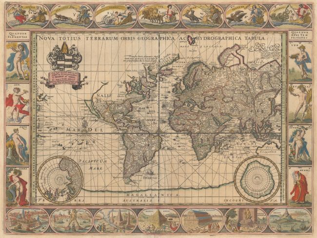
Auction 150, Lot 20
Subject: World
Pitt, Moses
Nova Totius Terrarum Orbis Geographica ac Hydrographica Tabula, 1680
Size: 20.9 x 15.7 inches (53.1 x 39.9 cm)
Estimate: $11,000 - $13,000
Pitt's Rare Carte-a-Figures Map in Full Original Color
Unsold
Closed on 9/17/2014
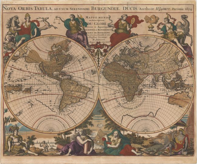
Auction 150, Lot 21
Subject: World
Jaillot, Alexis-Hubert
Nova Orbis Tabula, ad Usum Serenissimi Burgundiae Ducis / Mappe Monde ou Description du Globe Terrestre & Aquatique Presentee a Monseigneur le Duc de Bourgogne…, 1694
Size: 24.3 x 19.5 inches (61.7 x 49.5 cm)
Estimate: $4,500 - $5,500
Jaillot's Lavishly Decorated World Map in Full Original Color
Unsold
Closed on 9/17/2014
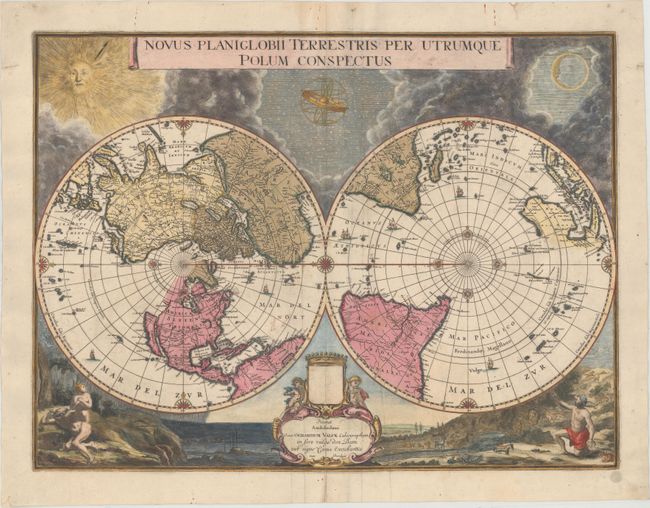
Auction 150, Lot 22
Subject: World
Blaeu/Valck
Novus Planiglobii Terrestris per Utrumque Polum Conspectus, 1695
Size: 21.1 x 15.9 inches (53.6 x 40.4 cm)
Estimate: $4,500 - $6,000
Superb World Map on a Polar Projection
Unsold
Closed on 9/17/2014
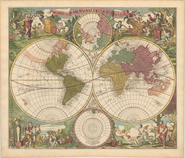
Auction 150, Lot 23
Subject: World
Valck, Gerard and Leonard
Orbis Terrarum Nova et Accurata Tabula, 1700
Size: 22.8 x 19.2 inches (57.9 x 48.8 cm)
Estimate: $5,500 - $6,500
Baroque-Style Double-Hemisphere Map Depicting the Four Seasons
Sold for: $4,000
Closed on 9/17/2014
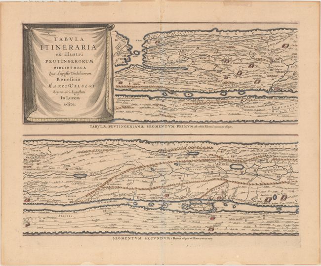
Auction 150, Lot 40
Subject: Ancient World
Jansson, Jan
[On 4 Sheets] Tabula Itineraria ex Illustri Peutingerorum Bibliotheca quae Augustae Vindelicorum Beneficio…, 1652
Size: 20.3 x 15.4 inches (51.6 x 39.1 cm)
Estimate: $3,500 - $4,250
Jansson's Famous Peutinger Table
Sold for: $2,500
Closed on 9/17/2014
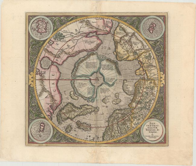
Auction 150, Lot 43
Subject: North Pole
Mercator/Hondius
Septentrionalium Terrarum Descriptio, 1623
Size: 15.7 x 14.6 inches (39.9 x 37.1 cm)
Estimate: $2,200 - $2,500
The First Printed Map Devoted to the Arctic
Sold for: $1,400
Closed on 9/17/2014
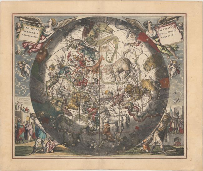
Auction 150, Lot 47
Subject: Celestial
Cellarius, Andreas
Haemisphaerium Stellatum Boreale cum Subiecto Haemisphaerio Terrestri, 1661
Size: 20.4 x 17.1 inches (51.8 x 43.4 cm)
Estimate: $3,500 - $4,500
Cellarius' Stunning Chart of the Northern Sky
Sold for: $2,400
Closed on 9/17/2014
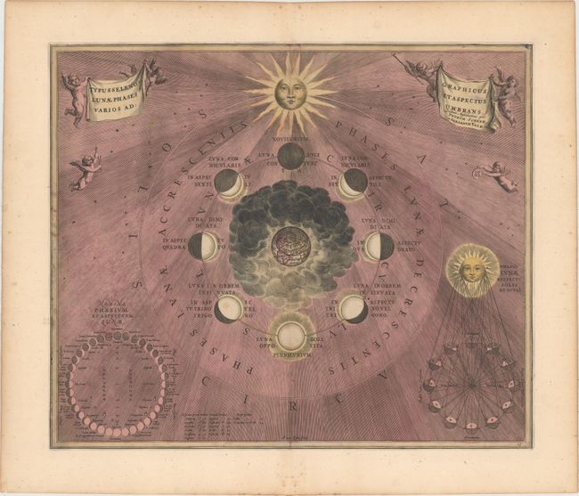
Auction 150, Lot 53
Subject: Solar System, Moon
Cellarius/Schenk & Valck
Typus Selenographicus Lunae Phases et Aspectus Varios Adumbrans, 1708
Size: 20.2 x 17 inches (51.3 x 43.2 cm)
Estimate: $1,900 - $2,200
Cellarius' Chart Depicting the Phases of the Moon
Sold for: $1,000
Closed on 9/17/2014
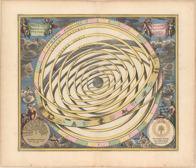
Auction 150, Lot 54
Subject: Solar System
Cellarius/Schenk & Valck
Orbium Planetarum Terram Complectentium Scenographia, 1708
Size: 19.7 x 16.9 inches (50 x 42.9 cm)
Estimate: $1,600 - $1,900
Cellarius' Chart of an Earth-Centric Solar System
Sold for: $1,200
Closed on 9/17/2014
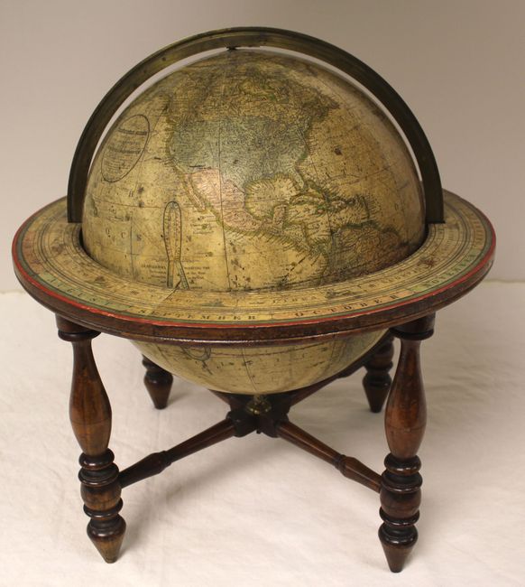
Auction 150, Lot 55
Subject: Globes
Joslin, Gilman
[12-Inch Globe] Loring's Terrestrial Globe Containing All the Late Discoveries and Geographical Improvements…, 1846
Size: 16 x 19 inches (40.6 x 48.3 cm)
Estimate: $7,500 - $9,000
One of the Earliest Globes to Depict the Southwest as a U.S. Possession
Unsold
Closed on 9/17/2014
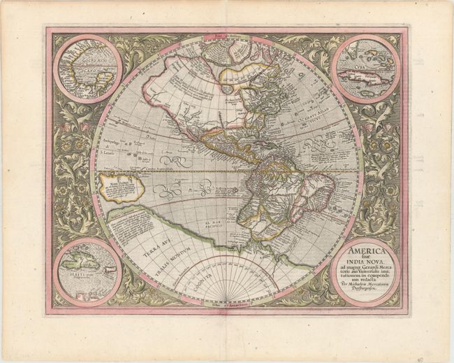
Auction 150, Lot 61
Subject: Western Hemisphere - America
Mercator, Michael
America sive India Nova, ad Magnae Gerardi Mercatoris aui Universalis Imitationem in Compendium Redacta, 1613
Size: 18.4 x 14.6 inches (46.7 x 37.1 cm)
Estimate: $4,500 - $5,500
Mercator's Foundation Map for the Americas
Sold for: $2,500
Closed on 9/17/2014
Auction 150, Lot 64
Subject: Western Hemisphere - America
Blaeu, Willem
Americae Nova Tabula, 1640
Size: 22 x 16.3 inches (55.9 x 41.4 cm)
Estimate: $6,000 - $7,000
Blaeu's Stunning Carte-a-Figures Map of the Americas
Sold for: $4,500
Closed on 9/17/2014
Auction 150, Lot 65
Subject: Western Hemisphere - America
Meurs, Jacob van
Novissima et Accuratissima Totius Americae Descriptio, 1673
Size: 21 x 16.8 inches (53.3 x 42.7 cm)
Estimate: $2,200 - $2,750
Meur's Decorative Map of the Americas with California as an Island
Sold for: $1,300
Closed on 9/17/2014
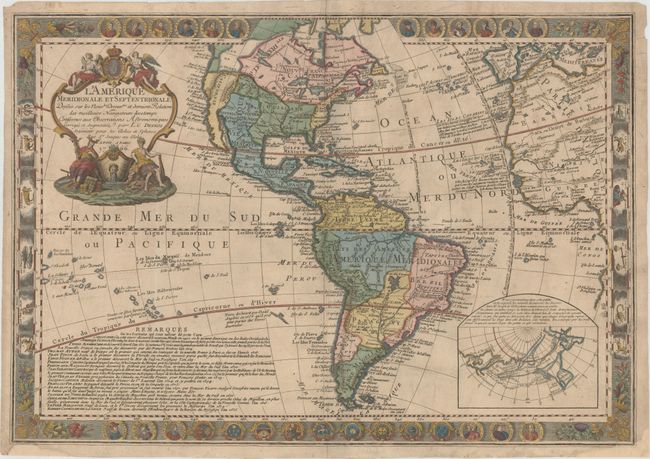
Auction 150, Lot 74
Subject: Western Hemisphere - America
Desnos, Louis Charles
L'Amerique Meridionale et Septentrionale Dressee sur les Nouvles Decouvtes et Dernieres Relations des Meilleurs Navigateurs Decetemps…, 1766
Size: 27 x 18.8 inches (68.6 x 47.8 cm)
Estimate: $2,750 - $3,500
Highly Decorative Map of the Americas
Unsold
Closed on 9/17/2014
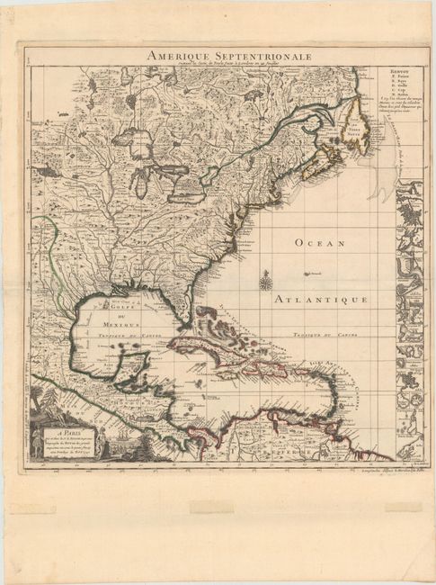
Auction 150, Lot 101
Subject: Colonial North America & West Indies
Popple/Le Rouge
Amerique Septentrionale suivant la Carte de Pople…, 1742
Size: 19.3 x 20 inches (49 x 50.8 cm)
Estimate: $2,200 - $2,500
Reduced Version of Popple's Map
Sold for: $1,600
Closed on 9/17/2014

Auction 150, Lot 103
Subject: Western North America & North Pacific Ocean
Bellin, Jacques Nicolas
Carte Reduite de l'Ocean Septentrional Compris Entre l'Asie et l'Amerique Suivant les Decouvertes qui ont ete Faites par les Russes..., 1766
Size: 33.3 x 21.9 inches (84.6 x 55.6 cm)
Estimate: $1,200 - $1,500
A Fascinating Map Showing Bering's Discoveries and the River and Lake Systems in North America
Sold for: $600
Closed on 9/17/2014
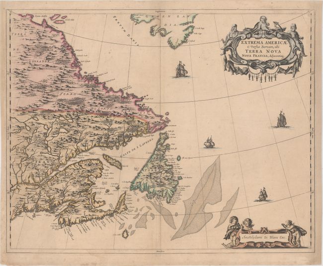
Auction 150, Lot 109
Subject: Eastern Canada
Blaeu, Johannes
Extrema Americae Versus Boream, ubi Terra Nova Nova Francia, Adjacentiaq, 1670
Size: 22.3 x 17.7 inches (56.6 x 45 cm)
Estimate: $2,000 - $2,300
Blaeu's Only Map of Canada, Showing the Canadian Maritimes
Sold for: $1,700
Closed on 9/17/2014
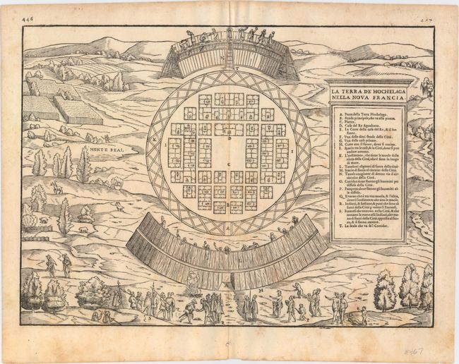
Auction 150, Lot 120
Subject: Montreal, Canada
Gastaldi/Ramusio
La Terra de Hochelaga nella Nova Francia, 1565
Size: 14.5 x 10.6 inches (36.8 x 26.9 cm)
Estimate: $2,200 - $2,500
The First Published Plan of a Settlement in North America
Sold for: $1,600
Closed on 9/17/2014
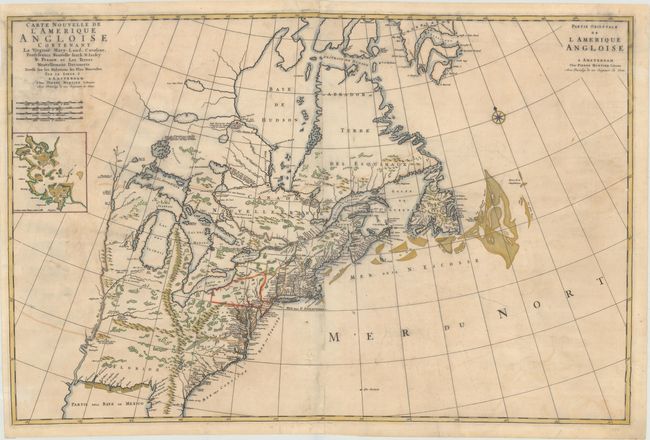
Auction 150, Lot 127
Subject: Colonial Eastern United States & Canada
Mortier, Pierre
Carte Nouvelle de l'Amerique Angloise Contenant la Virginie, Mary-Land, Caroline, Pensylvania, Nouvelle Iorck, N: Iarsey N: France, et les Terres Nouvellement Decouerte..., 1700
Size: 36 x 23.5 inches (91.4 x 59.7 cm)
Estimate: $2,500 - $3,250
A Map Showing Fascinating Geographic Misconceptions
Unsold
Closed on 9/17/2014
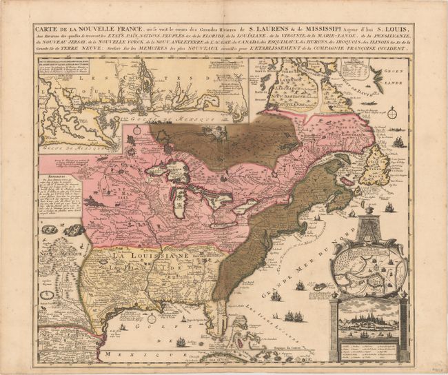
Auction 150, Lot 128
Subject: Colonial Eastern United States & Canada
Fer, Nicolas de
Carte de la Nouvelle France, ou se voit le cours des Grandes Rivieres de S. Laurens & de Mississipi, Aujour d'hui S. Louis…, 1719
Size: 21.7 x 19.6 inches (55.1 x 49.8 cm)
Estimate: $1,600 - $1,900
Striking Map of French Colonial Possessions
Sold for: $1,900
Closed on 9/17/2014
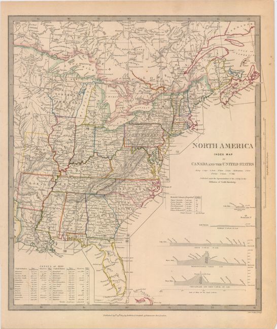
Auction 150, Lot 132
Subject: Eastern United States & Canada
SDUK Society for the Diffusion of Useful Knowledge
[Lot of 15 - North America], 1832-34
Size: 12 x 15 inches (30.5 x 38.1 cm)
Estimate: $1,500 - $2,000
Matching Set of North America SDUK Maps
Sold for: $800
Closed on 9/17/2014
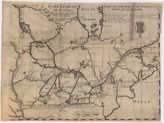
Auction 150, Lot 133
Subject: Colonial Northeastern United States & Canada, Great Lakes
Lahontan, Louis Armand, Baron de
Carte Generale de Canada. Dediee au Roy de Danemark par Son Tres Humble et Tres Obeissant et Tres Fidele Serviteur Lahontan, 1705
Size: 21.5 x 16.6 inches (54.6 x 42.2 cm)
Estimate: $2,000 - $2,400
Lahontan's Map of Canada and the Great Lakes
Sold for: $1,200
Closed on 9/17/2014
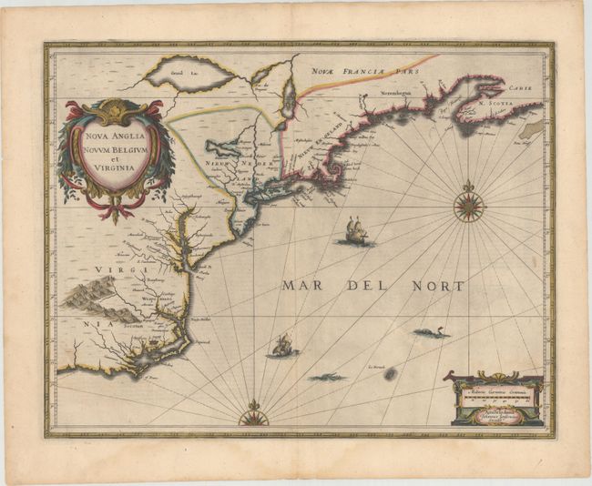
Auction 150, Lot 165
Subject: Colonial New England & Mid-Atlantic United States
Jansson, Jan
Nova Anglia Novum Belgium et Virginia, 1638
Size: 19.8 x 15.3 inches (50.3 x 38.9 cm)
Estimate: $1,600 - $1,900
Jansson's Influential Map of the East Coast
Sold for: $1,400
Closed on 9/17/2014
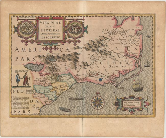
Auction 150, Lot 174
Subject: Colonial Southeast United States
Hondius, Jodocus
Virginiae Item et Floridae Americae Provinciarum, Nova Descriptio, 1623
Size: 19.2 x 13.6 inches (48.8 x 34.5 cm)
Estimate: $2,750 - $3,500
A Seminal Map of the Southeast and Early American Cartography
Unsold
Closed on 9/17/2014
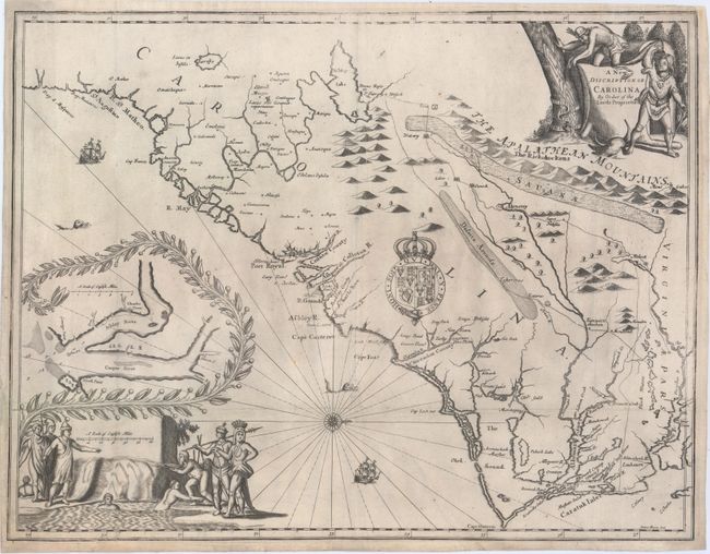
Auction 150, Lot 176
Subject: Colonial Southeast United States
Moxon/Ogilby
A New Discription of Carolina by Order of the Lords Proprietors, 1673
Size: 21.3 x 16.3 inches (54.1 x 41.4 cm)
Estimate: $12,000 - $15,000
Ogilby's Scarce and Influential First Lords Proprietors Map
Unsold
Closed on 9/17/2014
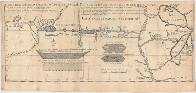
Auction 150, Lot 195
Subject: Colonial Central United States, River Longue
Lahontan, Louis Armand, Baron de
Carte que les Gnacsitares ont Dessine sur ... Carte de la Riviere Longue et de Quelques Autres qui se Dechargent dans le Grand Fleuve Missisipi …, 1703
Size: 26.1 x 11 inches (66.3 x 27.9 cm)
Estimate: $1,400 - $1,700
First Edition of Lahontan's Influential Map Depicting "Riviere Longue"
Sold for: $1,200
Closed on 9/17/2014
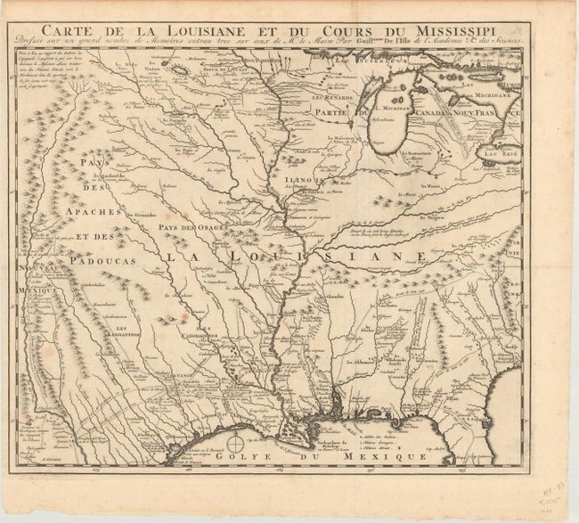
Auction 150, Lot 196
Subject: Colonial Central United States, Louisiana Territory
Delisle, Guillaume
Carte de la Louisiane et du Cours du Mississipi Dressee sur un Grand Nombre de Memoires Entrau Tres sur Ceux de Mr. le Maire, 1720
Size: 16.1 x 14 inches (40.9 x 35.6 cm)
Estimate: $1,600 - $1,900
Reduced-Size Edition of Delisle's Influential Map of the Louisiana Territory
Unsold
Closed on 9/17/2014
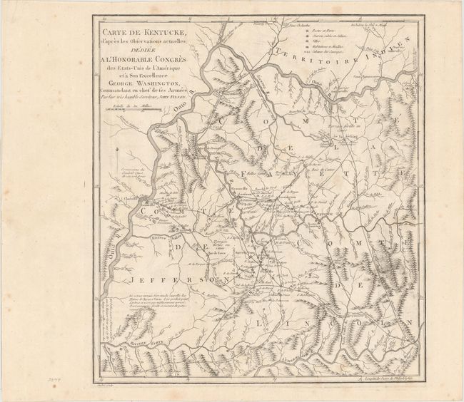
Auction 150, Lot 235
Subject: Kentucky
Filson, John
Carte de Kentucke, d'Apres les Observations Actuelles; Dediee a l'Honorable Congres des Etas-Unis de l'Amerique et a Son Excellence George Washington..., 1785
Size: 12.4 x 13.7 inches (31.5 x 34.8 cm)
Estimate: $2,500 - $3,250
The First Map of Kentucky
Unsold
Closed on 9/17/2014

Auction 150, Lot 245
Subject: Boston, Massachusetts
Stedman, Charles
A Plan of the Action at Bunkers Hill, on the 17th of June 1775. Between His Majesty's Troops, Under the Command of Major General Howe, and the American Forces: Engraved for Stedman's History of the American War, 1793
Size: 16.7 x 18.9 inches (42.4 x 48 cm)
Estimate: $1,000 - $1,300
The Most Precise and Detailed Plan of the Battle of Bunker Hill
Sold for: $1,100
Closed on 9/17/2014
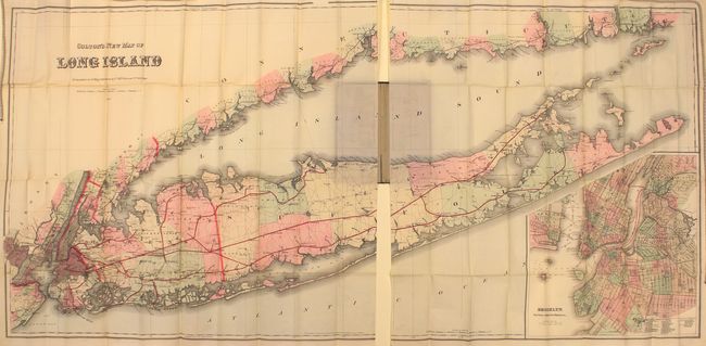
Auction 150, Lot 267
Subject: Long Island, New York
Colton, G.W. & C.B.
Colton's New Map of Long Island, 1886
Size: 63.9 x 30.2 inches (162.3 x 76.7 cm)
Estimate: $4,500 - $5,500
Monumental Map of Long Island in Mint Condition
Unsold
Closed on 9/17/2014
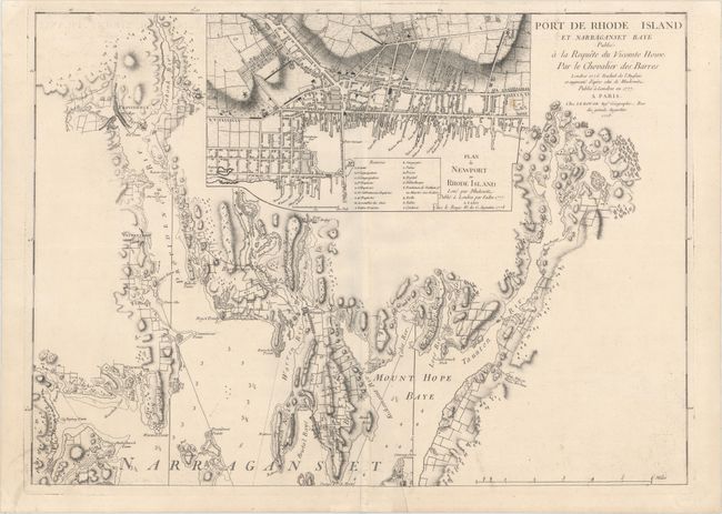
Auction 150, Lot 281
Subject: Narragansett Bay, Rhode Island
Le Rouge, George Louis
Port de Rhode Island et Narraganset Baye Publie a la Requete du Vicomte Howe par le Chevalier des Barres..., 1778
Size: 27.6 x 19.8 inches (70.1 x 50.3 cm)
Estimate: $1,500 - $1,800
Le Rouge's Impressive Chart of Narragansett Bay, RI
Sold for: $550
Closed on 9/17/2014
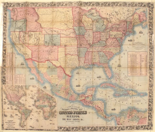
Auction 150, Lot 298
Subject: United States, Mexico & Central America
Colton, Joseph Hutchins
Colton's Rail-Road and Military Map of the United States Mexico, the West Indies &c., 1861
Size: 38.7 x 32.3 inches (98.3 x 82 cm)
Estimate: $1,200 - $1,500
Rare 1861 Colton Issue
Sold for: $750
Closed on 9/17/2014
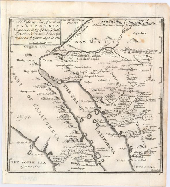
Auction 150, Lot 310
Subject: Southwestern United States & Mexico
Kino, Eusebio Francisco, SJ
A Passage by Land to California Discover'd by ye Rev. Fathr. Eusebius Francis Kino Jesuite Between ye Year 1698 & 1701, 1721
Size: 7.8 x 7.8 inches (19.8 x 19.8 cm)
Estimate: $1,000 - $1,300
Father Kino's Important Map of California
Sold for: $550
Closed on 9/17/2014
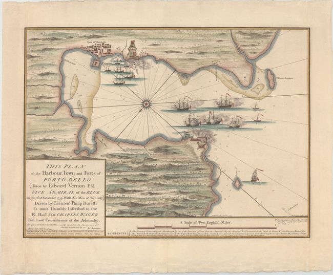
Auction 150, Lot 325
Subject: Portobello, Panama
Durell, Philip
This Plan of the Harbour, Town and Forts of Porto Bello..., 1740
Size: 23.1 x 17 inches (58.7 x 43.2 cm)
Estimate: $800 - $1,000
Rare Chart of the Battle of Portobello
Sold for: $600
Closed on 9/17/2014
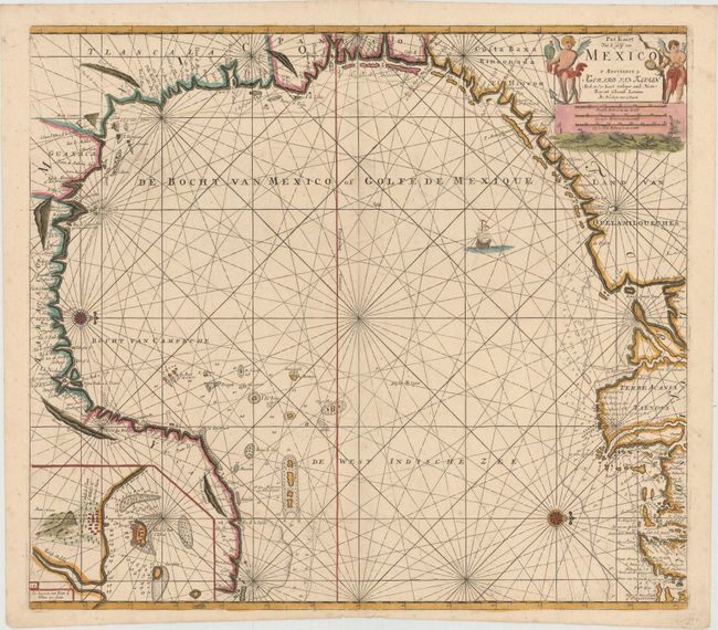
Auction 150, Lot 326
Subject: Gulf of Mexico
Keulen, Gerard Hulst van
Pas Kaart van de Golff van Mexico, 1684
Size: 23 x 20.4 inches (58.4 x 51.8 cm)
Estimate: $3,000 - $3,750
The First Sea Chart of the Western Portion of the Gulf of Mexico
Sold for: $1,500
Closed on 9/17/2014
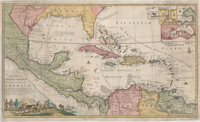
Auction 150, Lot 332
Subject: Gulf of Mexico and Caribbean
Morden/Moll
A New Mapp of the West-Indies, or the Islands of America in the North Sea; Together with the Adjacent Dominions..., 1740
Size: 40 x 23.4 inches (101.6 x 59.4 cm)
Estimate: $4,500 - $5,500
Scarce Early Edition of Moll's Map of the Gulf of Mexico
Unsold
Closed on 9/17/2014
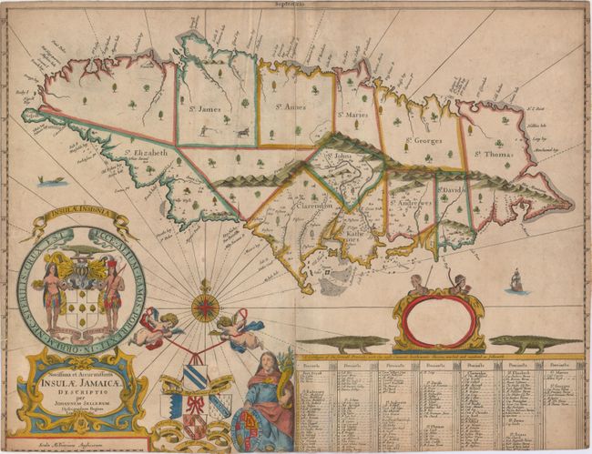
Auction 150, Lot 340
Subject: Jamaica
Seller, John
Novissima et Accuratissima Insulae Jamaicae Descriptio, 1671
Size: 21.2 x 16.3 inches (53.8 x 41.4 cm)
Estimate: $1,000 - $1,300
First State of Very Rare Chart of Jamaica
Sold for: $1,500
Closed on 9/17/2014
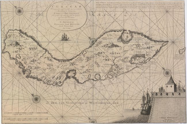
Auction 150, Lot 348
Subject: Curacao
Keulen, Gerard van
Nieuwe Afteekening van het Eyland Curacao..., 1751
Size: 23.3 x 15.6 inches (59.2 x 39.6 cm)
Estimate: $2,400 - $3,000
One of the Earliest Detailed Maps of Curacao
Unsold
Closed on 9/17/2014
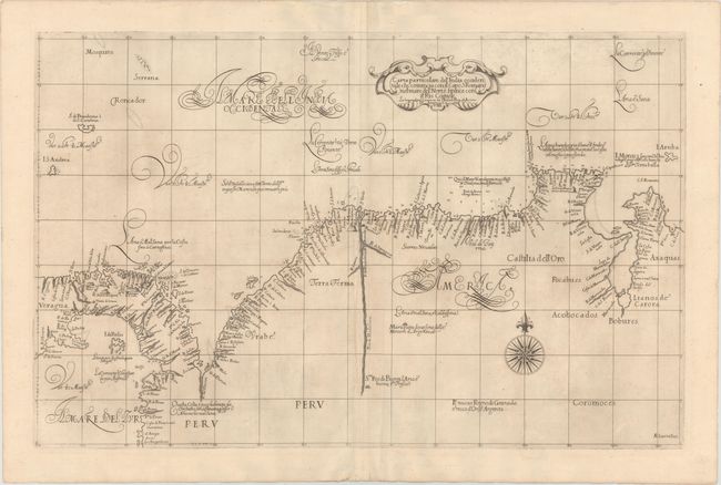
Auction 150, Lot 367
Subject: Colombia, Panama, and Venezuela
Dudley, Robert (Sir)
Carta Particolare del' India Occidentale che Comincia con il Capo S: Romano nel' Mare del' Nort, e finisce con il' Rio Coquele…, 1647
Size: 29.5 x 18.9 inches (74.9 x 48 cm)
Estimate: $2,000 - $2,300
Rare First State of Dudley's Chart of Colombia, Panama and Venezuela
Sold for: $1,800
Closed on 9/17/2014
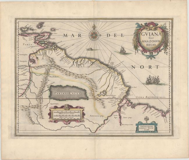
Auction 150, Lot 371
Subject: Guyana, Suriname, French Guiana
Blaeu, Willem
Guiana sive Amazonum Regio, 1642
Size: 19.4 x 14.7 inches (49.3 x 37.3 cm)
Estimate: $350 - $425
Unique Example with an Interesting Printing Error
Sold for: $180
Closed on 9/17/2014
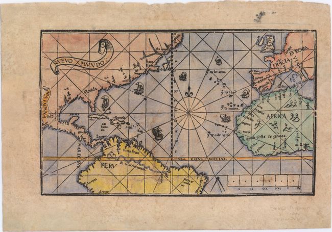
Auction 150, Lot 392
Subject: North Atlantic
De Medina, Pedro
Nuevo Mundo, 1545
Size: 9.6 x 5.8 inches (24.4 x 14.7 cm)
Estimate: $10,000 - $15,000
Extremely Rare First State of Medina's Map
Sold for: $8,500
Closed on 9/17/2014
Auction 150, Lot 393
Subject: North Atlantic
Coronelli, Vincenzo Maria
[Untitled - Globe Gore of the Atlantic Ocean], 1697
Size: 11 x 18 inches (27.9 x 45.7 cm)
Estimate: $1,500 - $1,800
Coronelli Globe Gore Showing the Northeast Coast of the United States
Sold for: $1,100
Closed on 9/17/2014
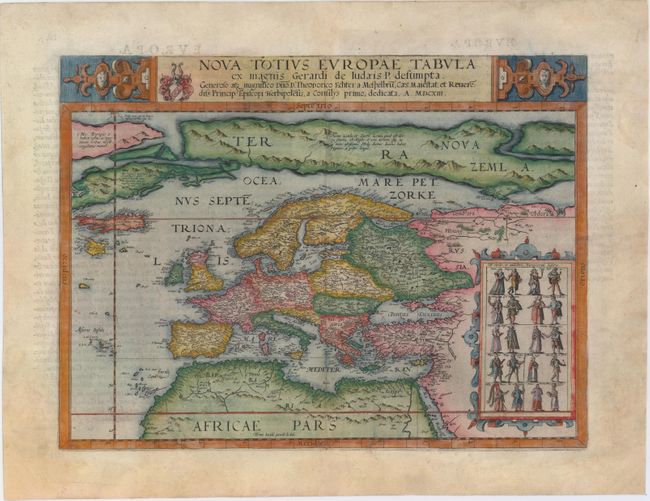
Auction 150, Lot 400
Subject: Europe
Jode, Gerard de
Nova Totius Europae Tabula ex Magnis Gerardi de Iudaeis P. Desumpta..., 1613
Size: 17.4 x 13 inches (44.2 x 33 cm)
Estimate: $6,000 - $7,500
De Jode's Very Rare Map of Europe
Sold for: $4,500
Closed on 9/17/2014
71 lots
Page 1 of 2