Subject: Gulf of Mexico and Caribbean
Period: 1740 (dated)
Publication:
Color: Hand Color
Size:
40 x 23.4 inches
101.6 x 59.4 cm
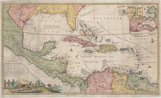
This fascinating map shows the islands and lands that were in possession of European colonial powers at the beginning of the 18th century. The map was originally compiled by Robert Morden and Herman Moll in 1702, and published by Morden, William Knight and Philip Lea. This edition is dated 1740 and no longer carries the imprint of its creators. Despite the name, this map was clearly a predecessor to Moll's very similar "A Map of the West-Indies or the Islands of America in the North Sea," first published circa 1715. Moll's later map has an updated title cartouche and numerous geographical improvements, particularly in Louisiana and Florida, where the mouth of the Mississippi River has been corrected.
The map labels the majority of the islands in the Caribbean as English, French, Dutch or Spanish, as well as various parts of the mainland. Carolina is labeled English and Louisana is labeled French, while Florida is not marked but was under Spanish rule at the time. The mouth of the Mississippi River, which is noted as having been discovered in 1683, is depicted too far west, just north of the Bravo River (Rio Grande). The map extends west to New Mexico and north to just show Charles Town.
Throughout the map are notations on trade routes, navigational tips, and information on resources. A note in the Gulf of Mexico explains that a ship can determine it's distance from the shore by calculating a depth sounding, as the number of fathoms to the bottom of the gulf is equal to the number of leagues to the shore. The Antilles Islands are noted as having been discovered by Columbus in 1492, with St. Salvador or Catt I. in the Bahamas being the first land that was discovered. The longitude is given as "Degrees from the Lizard" - meaning the distance from the Lizard, a peninsula in Cornwall and the most southerly point of the British mainland.
In the top right corner are four inset maps showing the important ports of Vera Cruz, Havana, Portobelo, and Cartagena. The title cartouche is depicted on a mountain with a scene of colonial trade below. A group of European traders unload empty wooden crates from a ship and fill them with gold bars and coins. A Native American appears to receive a pair of shoes in exchange, while other natives can be seen carrying pickaxes in the background, entering a mine. On two sheets, joined.
References:
Condition: B
A nice impression and attractive color with light soiling. Issued folding and now professionally backed on tissue to repair several fold separations and tears in the image, including one that extends 4" into Colombia, one that extends 3" in the Gulf of Mexico just above the ship, and one that extends 7" through the title cartouche. Chips in both corners at right have also been professionally repaired, with a portion of the image expertly replaced in facsimile. Despite these imperfections, the map presents itself very well.