Subject: Jamaica
Period: 1671 (published)
Publication: Atlas Maritimus
Color: Hand Color
Size:
21.2 x 16.3 inches
53.8 x 41.4 cm
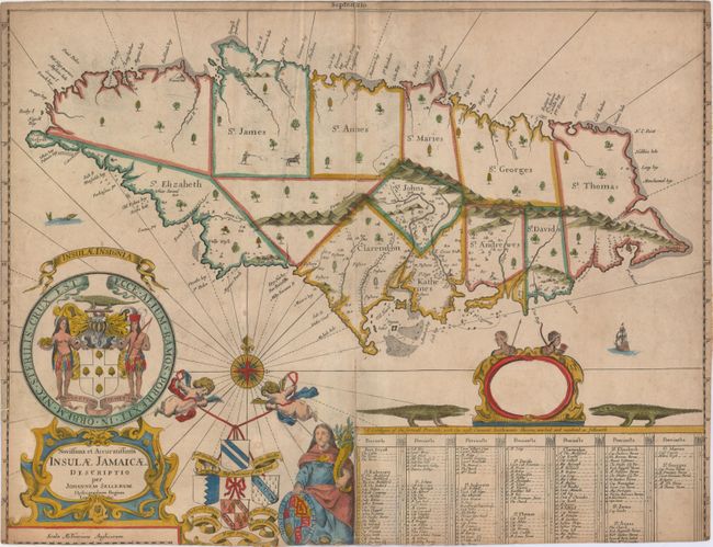
This is the first state of a very rare English map showing the island divided into precincts. In 1670, Sir Thomas Modyford ordered a survey of the island, which was completed by John Man, the Surveyor General of Jamaica from 1661-71. The following year, John Seller, John Ogilby and Richard Blome each used the survey to publish maps of Jamaica.
Seller's map, which closely resembles Ogilby's version, depicts the most prominent settlements with the landowners named in the large key at bottom. Port Royal is correctly located, and there are numerous settlements shown in the southern portion of the island. Anchorages, rocks, shoals and depth soundings are identified along the coastline. The map is handsomely embellished with a strapwork title cartouche supporting the coat of arms of Jamaica and putti holding aloft the coats of arms of Governors of the island: Doyley, Winsor, Modiford and Lynch. The large dedication cartouche is left blank, surmounted by Indians and flanked by alligators. Additional decorative elements include a man shooting a bull, a compass rose, a sea monster and a sailing ship.
John Seller was a pioneering British publisher of nautical charts and one of the most important figures in the early history of British cartography. Seller's shop, located near the Tower of London in Wapping, became a gathering place for seamen arriving with the latest news of distant places and provided Seller with information critical to his nautical chart business. In addition to sea charts he produced a vast array of cartographic material, the first to rival the large Dutch firms such as Blaeu and Jansson. Seller was appointed Royal Hydrographer by Charles II in 1671, and also served under James II and William III. Unfortunately his business was built on a shaky foundation and though he made several attempts to avoid bankruptcy, including a consortium partnership with other cartographers such as William Fisher and John Thornton, he was ultimately unsuccessful. As a result Seller's maps are quite rare on the market
References: Kapp (MCC-42) #14 (state 1); Blake, p. 113; Shirley (BL Atlases) M.SELL-3a #28.
Condition: C+
A nice impression with attractive color, light soiling, minor toning, an extraneous horizontal crease and a couple of very tiny holes. There are archivally repaired centerfold separations that enter map 1" at top and 5.5" at bottom. The map has been trimmed on all sides, with complete loss of the neatline and loss of the border and a small amount of the image at bottom.