Advanced Search
Showing Featured Lots(remove filter)
Filtered by Category:United States(Show All Categories)
Showing results for:Advanced search criteria below
Title
Word or word-fragment will be found anywhere within title, e.g. terr finds Terra, Terra Incognita, Territory, etc.
Geography
Word or word-fragment will be found anywhere within geography/subject, e.g. africa finds South Africa, African, etc.
Creator
Word or word-fragment will be found anywhere within creator's name(s).
Description
Word or word-fragment will be found anywhere within the lot description. Search will return exact matches only.
Period
Enter full year or year-fragment. 17 finds all items from the 1700s, 186 finds all from the 1860s.
Low Estimate Range
Find lots with low estimate equal to range selected.
Condition
Select condition to include in search.
Auction Date Range
Limits lots to a specific year or range of years (valid entries are 1999-present).
Catalog Archive
185 lots
Page 1 of 4
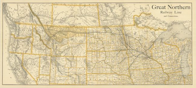
Auction 208, Lot 137
Subject: Western United States & Canada, Railroads
Railroad Companies, (Various)
Great Northern Railway Line and Connections, 1890
Size: 35.6 x 15.6 inches (90.4 x 39.6 cm)
Estimate: $250 - $325
Scarce Railroad Map with Bizarre Depictions of Montana and Wyoming. Colorado Is Off the Map!
Sold for: $180
Closed on 4/22/2026
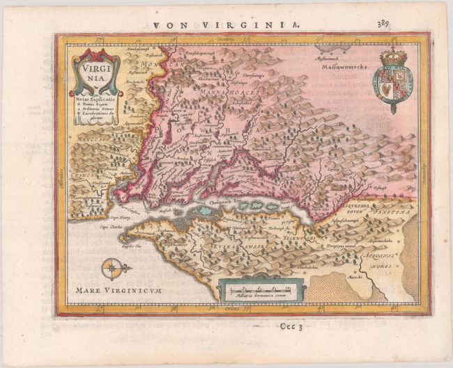
Auction 192, Lot 177
Subject: Colonial Mid-Atlantic United States
Jansson, Jan
Virginia, 1648
Size: 7.6 x 5.8 inches (19.3 x 14.7 cm)
Estimate: $750 - $900
Rare Edition of Atlas Minor Map of Virginia
Sold for: $1,100
Closed on 4/26/2023
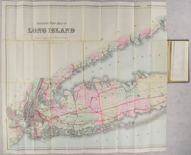
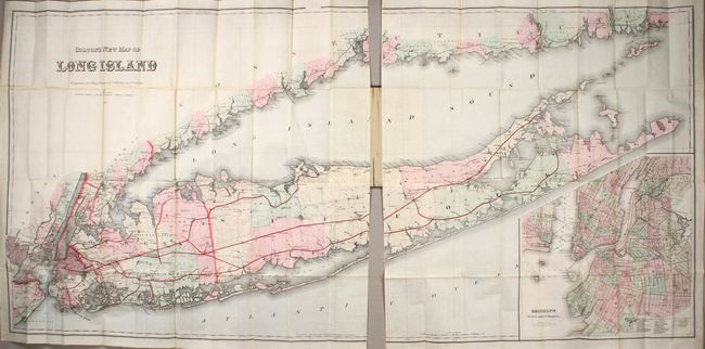
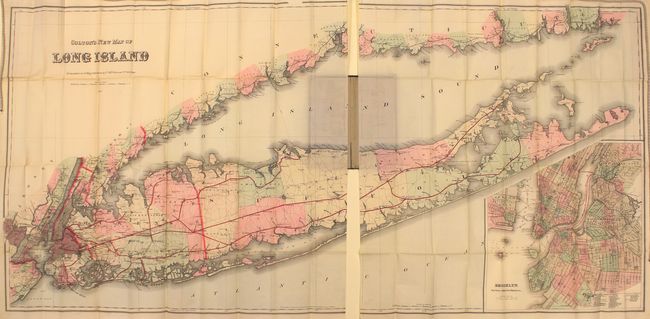
Auction 192, Lot 284
Subject: Long Island, New York
Colton, G.W. & C.B.
Colton's New Map of Long Island, 1886
Size: 64 x 30 inches (162.6 x 76.2 cm)
Estimate: $2,750 - $3,500
Monumental Map of Long Island in Mint Condition
Sold for: $1,400
Closed on 4/26/2023
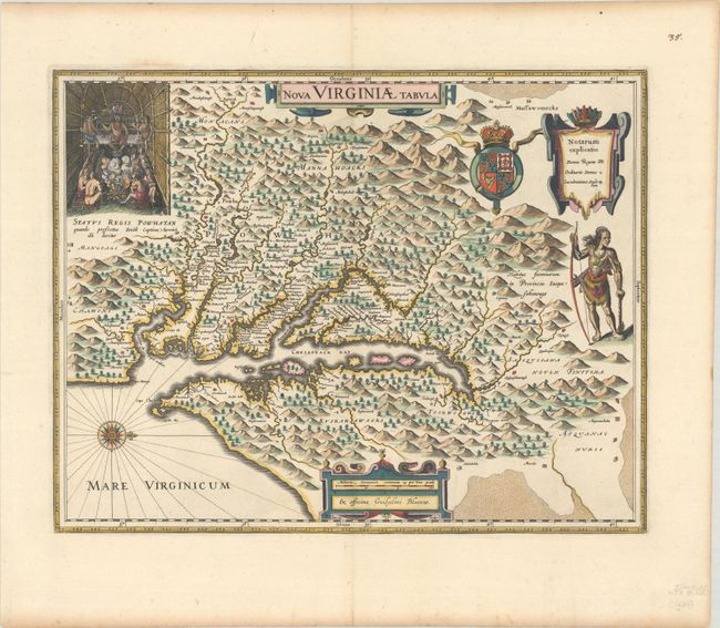
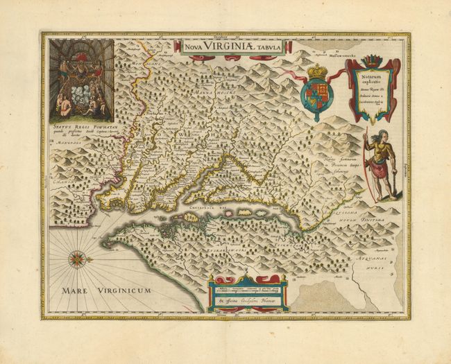
Auction 191, Lot 184
Subject: Colonial Mid-Atlantic United States
Hondius/Blaeu
Nova Virginiae Tabula, 1630
Size: 18.8 x 14.8 inches (47.8 x 37.6 cm)
Estimate: $2,000 - $2,300
One of the Most Important 17th Century Maps of the Chesapeake Bay
Sold for: $2,000
Closed on 2/8/2023
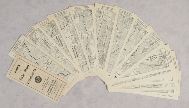
Auction 185, Lot 256
Subject: California
Automobile Club of Southern California
[Lot of 145 - Automobile Club of Southern California Strip Maps & Index Map], 1920
Size: 2.9 x 8.6 inches (7.4 x 21.8 cm)
Estimate: $600 - $800
Complete Run of ACSC Strip Maps
Sold for: $550
Closed on 11/17/2021
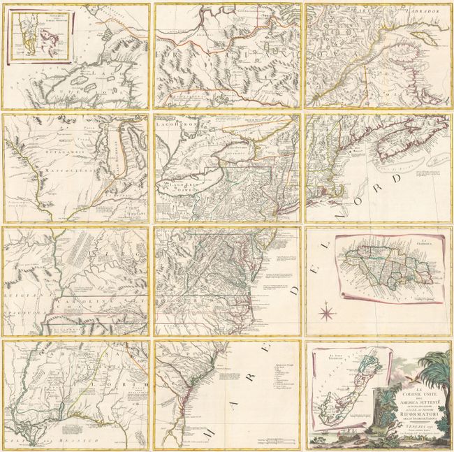
Auction 184, Lot 141
Subject: Colonial Eastern United States & Canada
Zatta, Antonio
[On 12 Sheets] Le Colonie Unite dell' America Settentrle. di Nuova Projezione... , 1778
Size: 16.7 x 12.5 inches (42.4 x 31.8 cm)
Estimate: $4,750 - $6,000
Impressive 12-Sheet Map of the New "United Colonies"
Sold for: $4,500
Closed on 9/15/2021
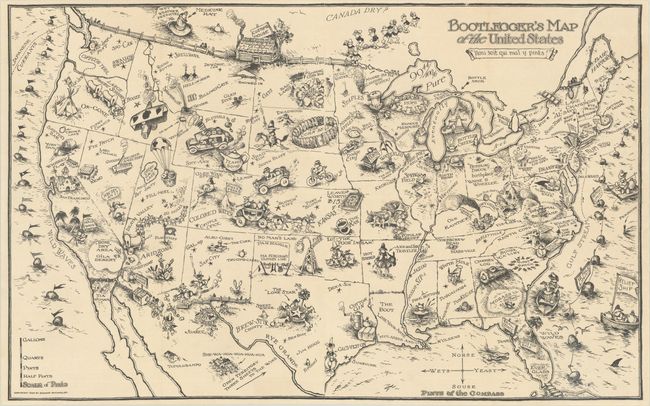
Auction 184, Lot 170
Subject: United States
Bootlegger's Map of the United States, 1926
Size: 33.9 x 21.3 inches (86.1 x 54.1 cm)
Estimate: $1,400 - $1,700
McCandlish's Humorous Prohibition Map
Sold for: $900
Closed on 9/15/2021
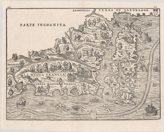
Auction 181, Lot 113
Subject: Colonial Northeastern United States & Canada
Gastaldi/Ramusio
La Nuova Francia, 1606
Size: 14.6 x 10.6 inches (37.1 x 26.9 cm)
Estimate: $3,500 - $4,250
The First Printed Map to Focus on New England and New France
Sold for: $2,750
Closed on 2/10/2021
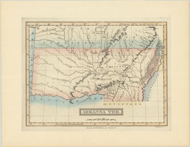
Auction 181, Lot 174
Subject: South Central United States, Arkansas
Lucas, Fielding
Arkansa Ter., 1822
Size: 11.2 x 8.2 inches (28.4 x 20.8 cm)
Estimate: $700 - $900
Rare First State of One of the Most Desirable Maps of Arkansas Territory
Sold for: $500
Closed on 2/10/2021
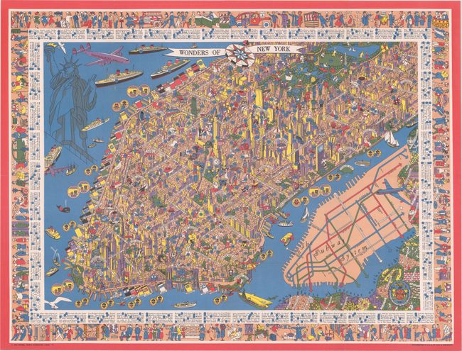
Auction 178, Lot 184
Subject: New York City, New York
Wonders of New York, 1953
Size: 31.8 x 24 inches (80.8 x 61 cm)
Estimate: $700 - $850
Superb Pictorial Map of Manhattan
Sold for: $650
Closed on 6/10/2020
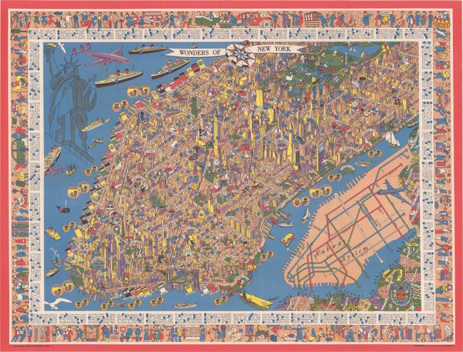
Auction 176, Lot 239
Subject: New York City, New York
Wonders of New York, 1953
Size: 31.5 x 23.6 inches (80 x 59.9 cm)
Estimate: $700 - $850
Superb Pictorial Map of Manhattan
Sold for: $650
Closed on 2/12/2020
Auction 170, Lot 291
Subject: Long Island, New York
Colton, G.W. & C.B.
Colton's New Map of Long Island, 1886
Size: 64 x 30 inches (162.6 x 76.2 cm)
Estimate: $3,500 - $4,250
Monumental Map of Long Island in Mint Condition
Unsold
Closed on 11/14/2018
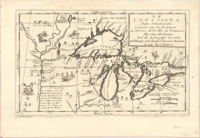
Auction 169, Lot 145
Subject: Colonial Central United States & Canada, Great Lakes
Coronelli, Vincenzo Maria
La Louisiana, Parte Settentrionalle, Scoperta Sotto la Protettione di Luigi XIV, Re di Francia, Etc., 1695
Size: 16.6 x 10.1 inches (42.2 x 25.7 cm)
Estimate: $3,500 - $4,250
Coronelli's Important Map of the Great Lakes & Upper Mississippi River Valley
Sold for: $4,000
Closed on 9/12/2018

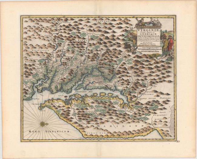
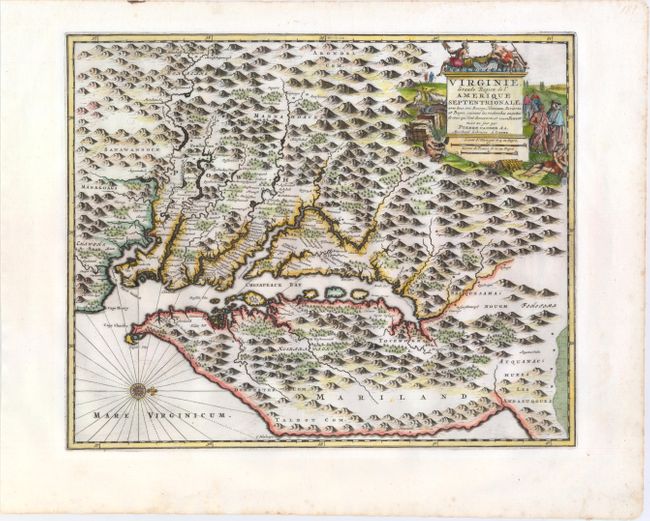
Auction 168, Lot 164
Subject: Colonial Mid-Atlantic United States
Aa, Pieter van der
Virginie, Grande Region de l'Amerique Septentrionale, avec tous Ses Bourgs, Hameaux, Rivieres et Bayes..., 1729
Size: 14.1 x 11.4 inches (35.8 x 29 cm)
Estimate: $1,600 - $1,900
Rare Derivative of John Smith's Map of the Chesapeake Bay
Sold for: $1,100
Closed on 6/6/2018
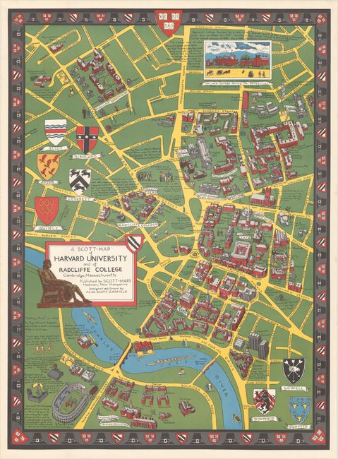
Auction 167, Lot 160
Subject: Massachusetts & New Hampshire
[Lot of 5] A Scott-Map of Harvard University and of Radcliffe College... [and] ... Boston Massachusetts [and] ... Concord Massachusetts... [and] ... the White Mountains of New Hampshire [and] Salem Massachusetts..., 1949-60
Size: See Description
Estimate: $350 - $450
A Wonderful Set of "Scott Maps"
Sold for: $375
Closed on 3/28/2018
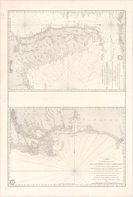
Auction 163, Lot 162
Subject: Colonial Southern United States
Depot de la Marine
Carte d'une Partie des Cotes de la Floride et de la Louisiane... [on sheet with] Carte Reduite des Cotes et de l'Interieur de la Presqu'ile de la Floride..., 1778-80
Size: 23.1 x 34.4 inches (58.7 x 87.4 cm)
Estimate: $3,000 - $4,000
Two Important Revolutionary War Charts
Sold for: $2,100
Closed on 6/14/2017
Auction 161, Lot 187
Subject: Colonial Mid-Atlantic United States
Aa, Pieter van der
Virginie, Grande Region de l'Amerique Septentrionale, avec tous Ses Bourgs, Hameaux, Rivieres et Bayes..., 1729
Size: 14.1 x 11.4 inches (35.8 x 29 cm)
Estimate: $1,800 - $2,100
Rare Derivative of John Smith's Map of the Chesapeake Bay
Unsold
Closed on 2/8/2017
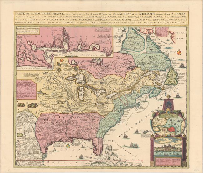
Auction 158, Lot 75
Subject: Colonial Eastern United States & Canada
Fer, Nicolas de
Carte de la Nouvelle France, ou Se Voit le Cours des Grandes Rivieres de S. Laurens & de Mississipi, Aujour d'hui S. Louis…, 1719
Size: 21.7 x 19.6 inches (55.1 x 49.8 cm)
Estimate: $2,750 - $3,500
Striking Map of French Colonial Possessions
Sold for: $2,100
Closed on 6/22/2016

Auction 157, Lot 192
Subject: Colonial Mid-Atlantic United States
Aa, Pieter van der
Virginie, Grande Region de l'Amerique Septentrionale, avec tous Ses Bourgs, Hameaux, Rivieres et Bayes..., 1729
Size: 14.1 x 11.4 inches (35.8 x 29 cm)
Estimate: $1,900 - $2,200
Rare Derivative of John Smith's Map of the Chesapeake Bay
Unsold
Closed on 5/4/2016

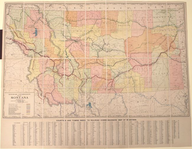
Auction 151, Lot 258
Subject: Montana, Railroads
Rand McNally & Co.
Railroad Commission Map of Montana, 1917
Size: 51.4 x 32.3 inches (130.6 x 82 cm)
Estimate: $900 - $1,100
Large, Attractive Railroad Map of Montana
Sold for: $450
Closed on 11/19/2014
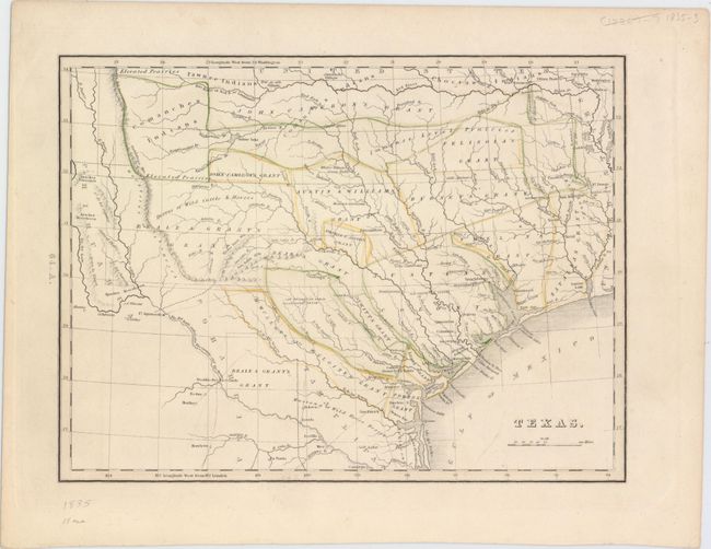
Auction 151, Lot 296
Subject: Texas
Bradford, Thomas Gamaliel
Texas, 1835
Size: 10.4 x 8.9 inches (26.4 x 22.6 cm)
Estimate: $2,500 - $3,250
First Separate Map of Texas in an American Atlas
Sold for: $2,100
Closed on 11/19/2014
Auction 150, Lot 267
Subject: Long Island, New York
Colton, G.W. & C.B.
Colton's New Map of Long Island, 1886
Size: 63.9 x 30.2 inches (162.3 x 76.7 cm)
Estimate: $4,500 - $5,500
Monumental Map of Long Island in Mint Condition
Unsold
Closed on 9/17/2014
Auction 149, Lot 145
Subject: Colonial Mid-Atlantic United States
Aa, Pieter van der
Virginie, Grande Region de l'Amerique Septentrionale, avec Tous Ses Bourgs, Hameaux, Rivieres et Bayes, Suivant les Recherches Exactes de Ceux qui l'ont Decouverte, et Nouvellement Mise au Jour, 1729
Size: 14.1 x 11.4 inches (35.8 x 29 cm)
Estimate: $1,800 - $2,000
Rare Derivative of John Smith's Map of the Chesapeake Bay
Sold for: $1,300
Closed on 5/21/2014
Auction 149, Lot 257
Subject: Montana, Railroads
Rand McNally & Co.
Railroad Commission Map of Montana, 1917
Size: 51.4 x 32.3 inches (130.6 x 82 cm)
Estimate: $900 - $1,100
Large, Attractive Railroad Map of Montana
Unsold
Closed on 5/21/2014
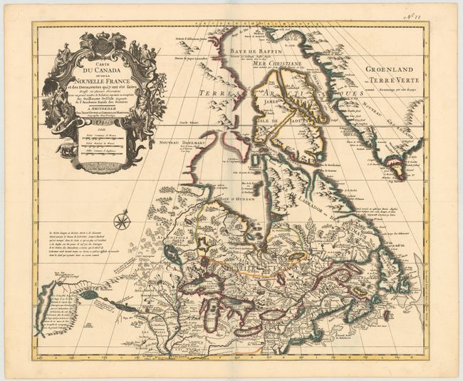
Auction 146, Lot 121
Subject: Colonial United States & Canada
Delisle/Covens & Mortier
Carte du Canada ou de la Nouvelle France et des Decouvertes quiy ont ete Faites..., 1730
Size: 22.6 x 19.3 inches (57.4 x 49 cm)
Estimate: $1,400 - $1,700
One of the most influential maps of Canada, the Great Lakes and Upper Midwest
Sold for: $1,300
Closed on 9/4/2013
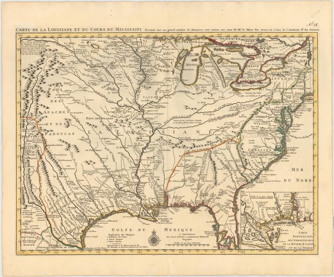
Auction 145, Lot 151
Subject: Colonial United States, Louisiana Territory
Delisle/Covens & Mortier
Carte de la Louisiane et du Cours du Mississipi Dressee sur un Grand Nombre de Memoires entr'autres sur ceux de Mr. le Maire, 1733
Size: 23.4 x 17.2 inches (59.4 x 43.7 cm)
Estimate: $3,000 - $3,750
Sold for: $2,750
Closed on 6/12/2013
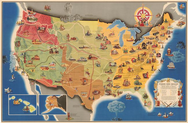
Auction 138, Lot 173
Subject: United States
Standard School Broadcast Pictorial Music - Map of the United States of America…, 1949
Size: 40 x 26 inches (101.6 x 66 cm)
Estimate: $400 - $500
Unusual Thematic Map of the United States
Sold for: $425
Closed on 12/7/2011

Auction 138, Lot 186
Subject: Eastern United States
Mitchell, Samuel Augustus
Mitchell's National Map of the American Republic or United States of North America, Together with Maps of the Vicinities of Thirty-Two of the Principal Cities and Towns in the Union, 1843
Size: 47 x 38 inches (119.4 x 96.5 cm)
Estimate: $2,400 - $3,000
Remarkable Example of Mitchell's Wall Map
Unsold
Closed on 12/7/2011

Auction 138, Lot 218
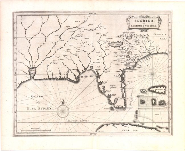
Subject: Colonial South
Gerritsz/De Laet
Florida, et Regiones Vicinae, 1630
Size: 14 x 11.3 inches (35.6 x 28.7 cm)
Estimate: $3,750 - $4,500
De Laet's Important Map of the South
Sold for: $3,000
Closed on 12/7/2011
Auction 138, Lot 301
Subject: Louisiana
Third Report from the Select Committee on Emigration from the United Kingdom, 1827
Size: 8.5 x 13.2 inches (21.6 x 33.5 cm)
Estimate: $1,500 - $2,200
Rare Parliamentary Report Regarding Emigration from Britain to the United States
Sold for: $850
Closed on 12/7/2011
Auction 137, Lot 227
Subject: Colonial South
Gerritsz/De Laet
Florida, et Regiones Vicinae, 1630
Size: 14 x 11.3 inches (35.6 x 28.7 cm)
Estimate: $3,750 - $4,500
Unsold
Closed on 9/14/2011
Auction 136, Lot 152
Subject: United States
Ensign, Thayer & Co.
Ensign's Travellers' Guide, and Map of the United States, Containing the Roads, Distances, Steam Boat and Canal Routes &c., 1848
Size: 39 x 26 inches (99.1 x 66 cm)
Estimate: $2,500 - $3,000
Flawless example of Ensign & Thayer's rare wall map
Sold for: $1,800
Closed on 6/1/2011
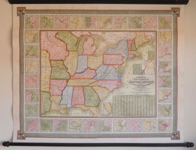
Auction 136, Lot 176
Subject: Eastern United States
Mitchell, Samuel Augustus
Mitchell's National Map of the American Republic or United States of North America, Together with Maps of the Vicinities of Thirty-Two of the Principal Cities and Towns in the Union, 1843
Size: 47 x 38 inches (119.4 x 96.5 cm)
Estimate: $2,500 - $3,000
Remarkable Example of Mitchell's Wall Map
Unsold
Closed on 6/1/2011
Auction 136, Lot 195
Subject: Colonial Mid-Atlantic
Hondius/Blaeu
Nova Virginiae Tabula, 1642
Size: 19 x 15 inches (48.3 x 38.1 cm)
Estimate: $2,750 - $3,500
One of the most important 17th century maps of the Chesapeake Bay
Sold for: $2,100
Closed on 6/1/2011

Auction 136, Lot 298
Subject: Louisiana
Third Report from the Select Committee on Emigration from the United Kingdom, 1827
Size: 8.5 x 13.2 inches (21.6 x 33.5 cm)
Estimate: $1,600 - $2,400
Rare Parliamentary Report Regarding Emigration from Britain to the United States
Unsold
Closed on 6/1/2011
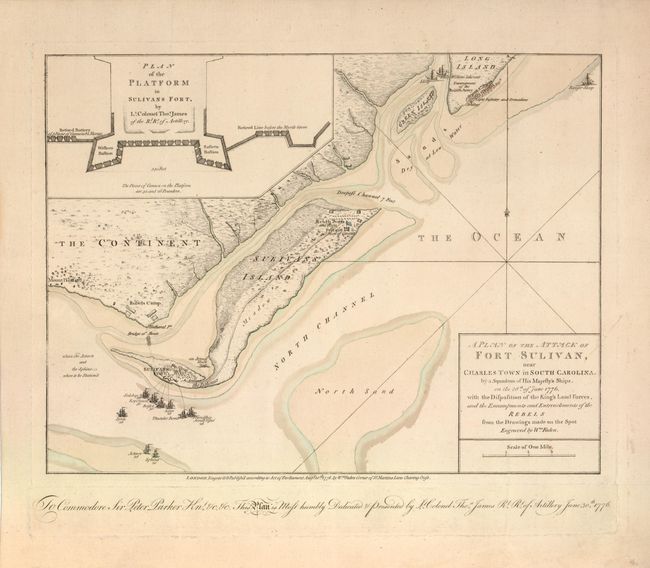
Auction 136, Lot 336
Subject: Charleston, South Carolina
Faden, William
A Plan of the Attack of Fort Sulivan, near Charles Town in South Carolina…, 1776
Size: 14.6 x 11 inches (37.1 x 27.9 cm)
Estimate: $10,000 - $12,000
Important Revolutionary War Map
Unsold
Closed on 6/1/2011
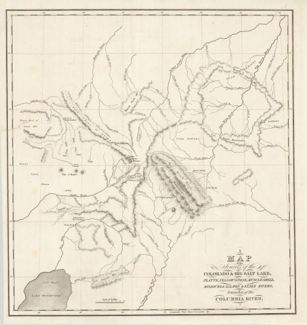
Auction 135, Lot 214
Subject: Western United States
Bonneville, Benjamin L. E. de
A Map of the Sources of the Colorado & Big Salt Lake, Platte, Yellow-Stone, Muscle-Shell, Missouri; & Salmon & Snake Rivers, branches of the Columbia River, 1837
Size: 15.5 x 16.5 inches (39.4 x 41.9 cm)
Estimate: $600 - $800
Sold for: $600
Closed on 2/16/2011
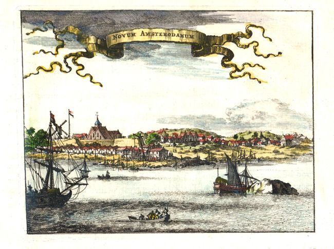
Auction 135, Lot 305
Subject: New York City
Montanus/Ogilby
Novum Amsterodamum, 1671
Size: 6.5 x 5 inches (16.5 x 12.7 cm)
Estimate: $550 - $650
Sold for: $425
Closed on 2/16/2011
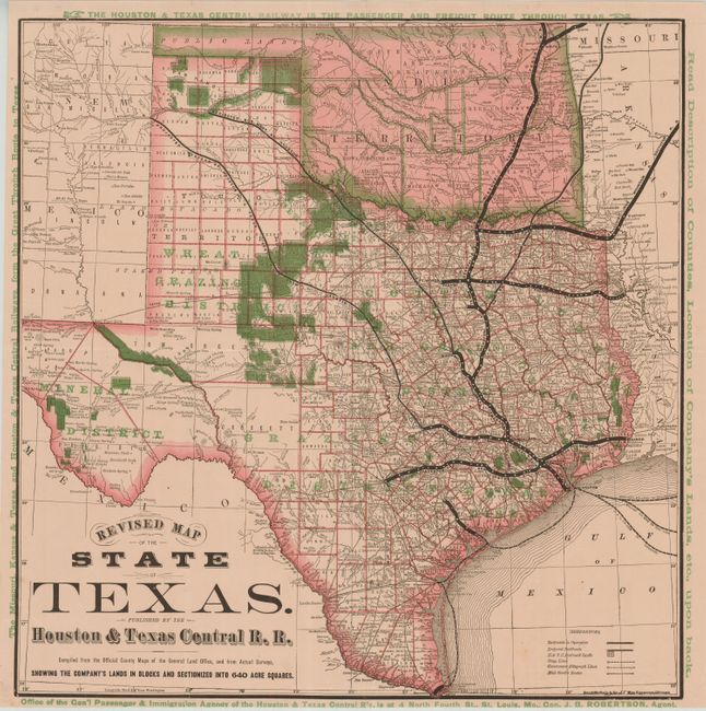
Auction 135, Lot 316
Subject: Texas
Rand McNally & Co.
Revised Map of the State of Texas. Published by the Houston & Texas Central R.R., 1879
Size: 19 x 19.3 inches (48.3 x 49 cm)
Estimate: $700 - $900
Sold for: $950
Closed on 2/16/2011
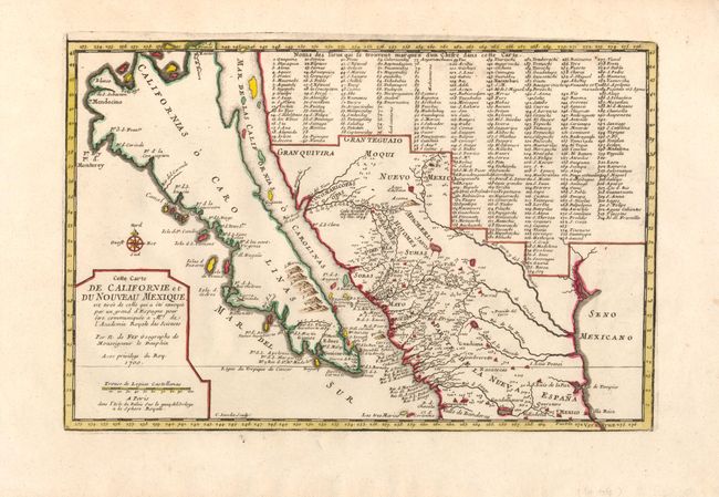
Auction 135, Lot 341
Subject: California, Southwest U.S., Mexico
Fer, Nicolas de
Cette Carte de Californie et du Nouveau Mexique…, 1700
Size: 13.3 x 8.8 inches (33.8 x 22.4 cm)
Estimate: $1,500 - $2,000
Sold for: $1,500
Closed on 2/16/2011
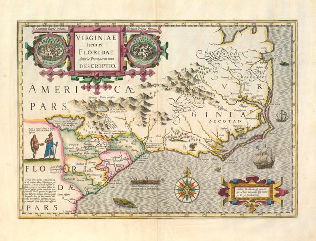
Auction 134, Lot 179
Subject: Colonial Southeast
Hondius, Jodocus
Virginiae Item et Floridae Americae Provinciarum, nova Descriptio, 1628
Size: 19 x 13.5 inches (48.3 x 34.3 cm)
Estimate: $3,250 - $4,000
Sold for: $2,750
Closed on 12/1/2010
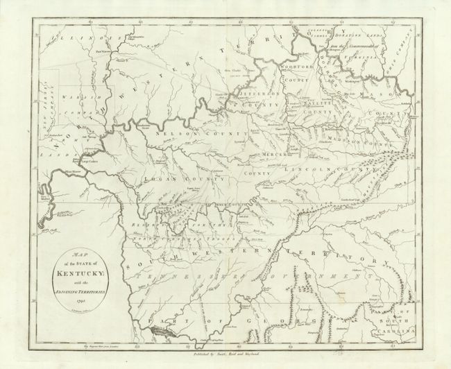
Auction 134, Lot 188
Subject: Southern United States - Kentucky and Tennessee
Reid, John
Map of the State of Kentucky; with the Adjoining Territories, 1795
Size: 17.4 x 14.6 inches (44.2 x 37.1 cm)
Estimate: $1,000 - $1,400
Sold for: $750
Closed on 12/1/2010
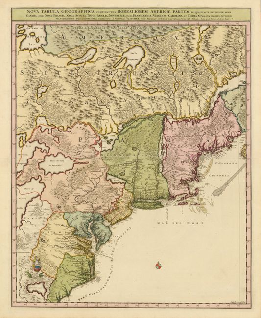
Auction 133, Lot 105
Subject: Colonial United States and Canada
Visscher/Schenk
[Lot of 2] Nova Tabula Geographica Complectens Borealiorem Americae Partem… [and] Carte Nouvelle contenant la Partie d'Amerique la Plus Septentrionale…, 1718
Size: 18.5 x 23 inches (47 x 58.4 cm)
Estimate: $3,000 - $4,000
Sold for: $2,200
Closed on 9/1/2010
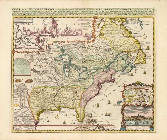
Auction 133, Lot 106
Subject: Colonial United States and Canada
Chatelain, Henry Abraham
Carte de la Nouvelle France, ou se voit le cours des Grandes Rivieres de S. Laurens & de Mississipi Aujour d'hui S. Louis, Aux Environs des-quelles se trouvent les Etats, Pais, Nations, Peuples &c., 1719
Size: 19.2 x 16.5 inches (48.8 x 41.9 cm)
Estimate: $2,500 - $3,000
Sold for: $3,250
Closed on 9/1/2010
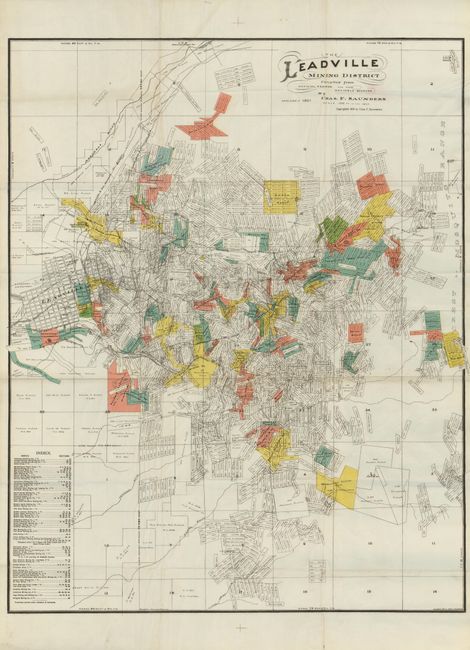
Auction 133, Lot 221
Subject: Colorado
The Leadville Mining District, 1901
Size: 30.5 x 38 inches (77.5 x 96.5 cm)
Estimate: $200 - $300
Sold for: $170
Closed on 9/1/2010
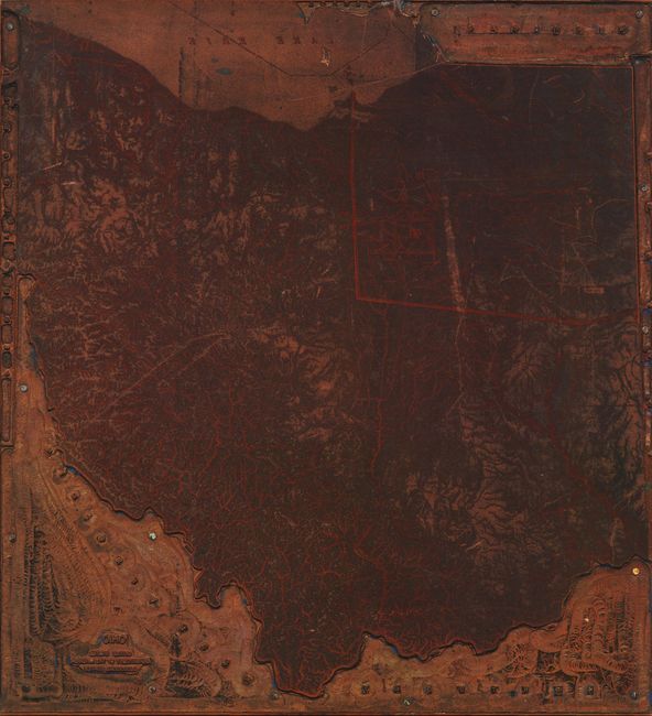
Auction 133, Lot 266
Subject: Ohio
U.S. Geographical Survey
[Copper Printing Plate] Ohio. United States Department of the Interior. Geological Survey., 1890-1920
Size: 8 x 8.5 inches (20.3 x 21.6 cm)
Estimate: $250 - $300
Sold for: $160
Closed on 9/1/2010
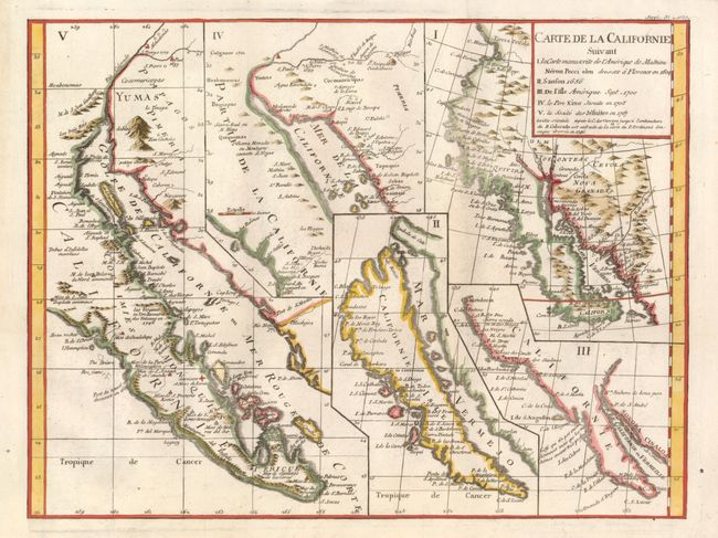
Auction 133, Lot 293
Subject: California and Baja Mexico
Robert de Vaugondy, Didier
Carte de la Californie Suivant I. La Carte Manuscrite de l'Amerique de Mathieu Neron Pecci Olen Dresse a Florence en 1604, II. Sanson 1656, III. De L'Isle Amerique Sept. 1700, IV. Le Pere Kino Jesuite en 1705, V. La Societe des Jesuites en 1767, 1777
Size: 15.2 x 11.4 inches (38.6 x 29 cm)
Estimate: $600 - $700
Sold for: $750
Closed on 9/1/2010
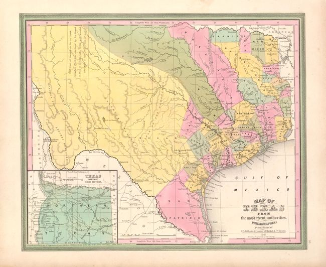
Auction 132, Lot 295
Subject: Texas
Williams, C. S.
Map of Texas from the most recent authorities, 1845
Size: 14.5 x 12 inches (36.8 x 30.5 cm)
Estimate: $900 - $1,200
Sold for: $1,300
Closed on 6/2/2010
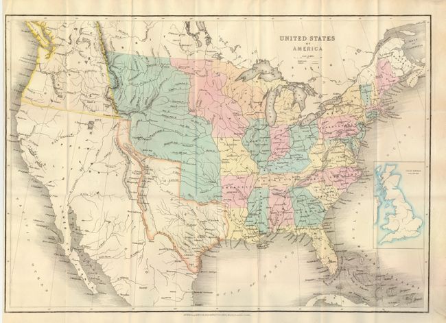
Auction 131, Lot 173
Subject: United States
Wyld, James
United States of America, 1845
Size: 21.3 x 14.8 inches (54.1 x 37.6 cm)
Estimate: $500 - $600
Sold for: $1,400
Closed on 3/17/2010
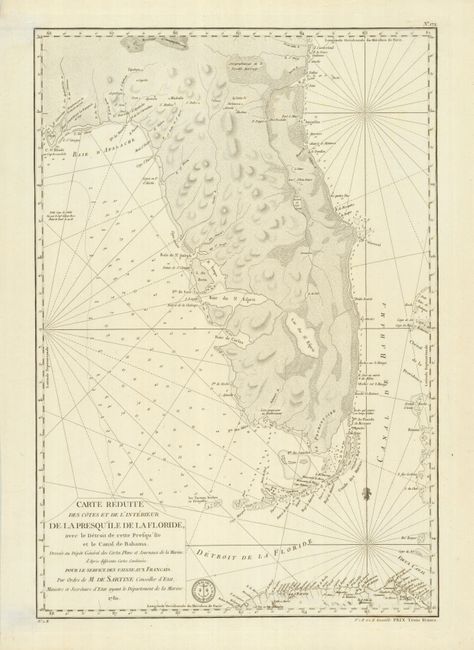
Auction 131, Lot 308
Subject: Florida
Sartine
Carte Reduite des Cotes et de l'Interieur de la Presqu'ile de la Floride, avec le Detroit de Cette Presqu'ile et le Canal de Bahama, 1780
Size: 15.5 x 22.8 inches (39.4 x 57.9 cm)
Estimate: $2,500 - $3,000
Sold for: $2,500
Closed on 3/17/2010
185 lots
Page 1 of 4