Subject: Texas
Period: 1938 (dated)
Publication: Oil and Gas Journal
Color: Printed Color
Size:
36.5 x 35.5 inches
92.7 x 90.2 cm
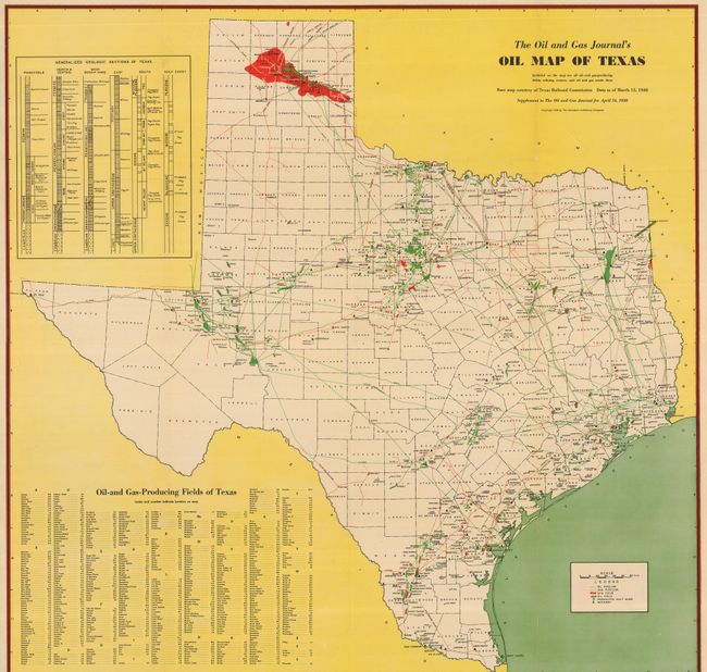
This great Texas oil map shows the state of the oil business throughout the entire state less than three years before America's entry into WWII. Highly detailed at a scale of 20 miles per inch, this very colorful map is from the base map provided courtesy of the Texas Railroad Commission with data current to March 15, 1938. It was published in the April 14, 1938 Supplement to the Oil and Gas Journal. The legend locates all Oil Pipelines, Gas Pipelines, Gas Fields, Oil Fields, Producing Salt Domes, and Refineries. At upper left is the large "Generalized Geological Sections of Texas" which locates many formations including those containing oil and gas as well as those to be Known, Probable or Possible "Pay Zones." The huge index to Texas' oil and gas fields lists over 500 fields alphabetically. The map is white with black printing to indicate counties and major towns. All oil related information is accomplished with colorful overprinting. Blank verso. This rare issue was published by the Petroleum Publishing Company.
References:
Condition: A+
Issued folding. Beautiful color and impression. Some light color ghosting in lower margin that appears to be an artifact of printing. Also some tissue on verso to support fold intersections on this large, heavy sheet.