Showing Featured Lots(remove filter)
Filtered by Category:United States(Show All Categories)
Showing results for:Auction 161
Catalog Archive
45 lots
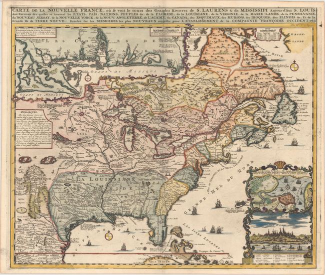
Auction 161, Lot 128
Subject: Colonial Eastern United States & Canada
Chatelain, Henry Abraham
Carte de la Nouvelle France, ou se voit le Cours des Grandes Rivieres de S. Laurens & de Mississipi Aujour d'hui S. Louis, aux Environs des-quelles se Trouvent les Etats, Pais, Nations, Peuples &c..., 1719
Size: 19.3 x 16.6 inches (49 x 42.2 cm)
Estimate: $3,000 - $3,750
One of the Most Informative 18th Century Maps of the French Possessions in North America
Sold for: $2,200
Closed on 2/8/2017
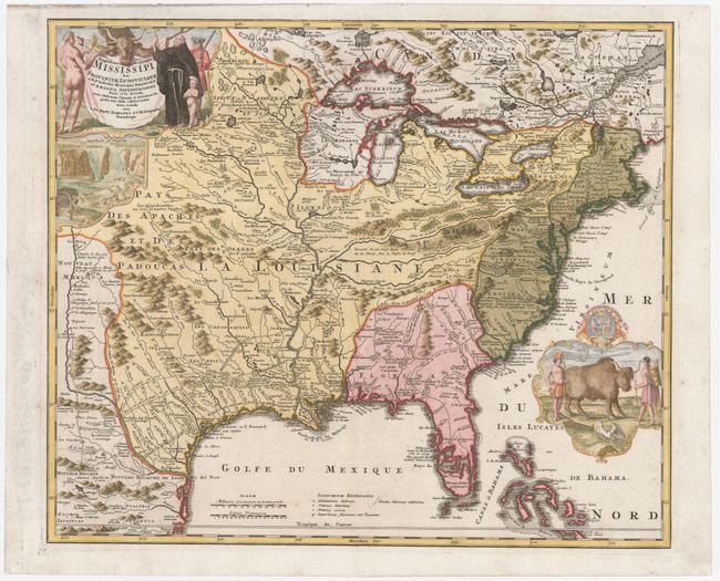
Auction 161, Lot 129
Subject: Colonial Eastern United States & Canada
Homann, Johann Baptist
Amplissimae Regionis Mississipi seu Provinciae Ludovicianae a R.P. Ludovico Hennepin Francisc Miss in America Septentrionali Anno 1687..., 1720
Size: 22.6 x 19.1 inches (57.4 x 48.5 cm)
Estimate: $2,200 - $2,500
Striking Map of Colonial America with Buffalo Vignette
Sold for: $2,300
Closed on 2/8/2017
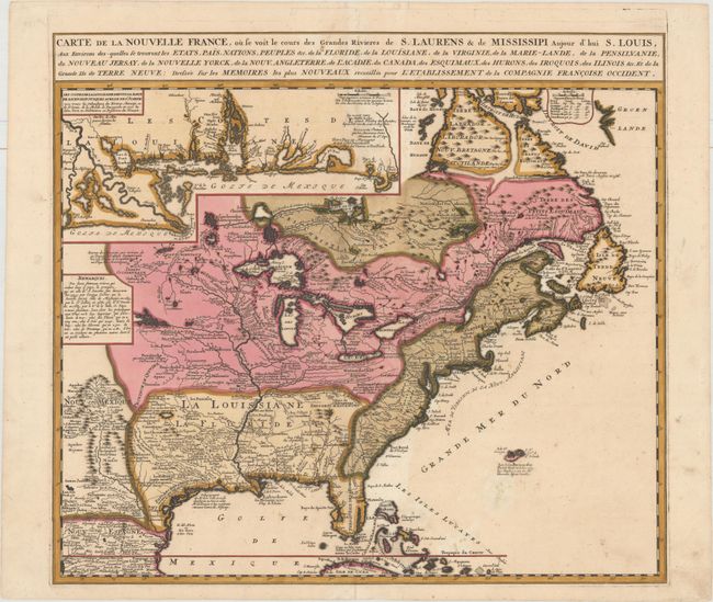
Auction 161, Lot 131
Subject: Colonial Eastern United States & Canada
Ottens/De Fer
Carte de la Nouvelle France, ou se voit le Cours des Grandes Rivieres de S. Laurens & de Mississipi Aujour d'hui S. Louis, aux Environs des-quelles se Trouvent les Etats, Pais, Nations, Peuples &c..., 1745
Size: 21.8 x 19.7 inches (55.4 x 50 cm)
Estimate: $2,300 - $2,750
Reduced Version of De Fer's Influential Map of French Possessions in North America
Sold for: $1,200
Closed on 2/8/2017
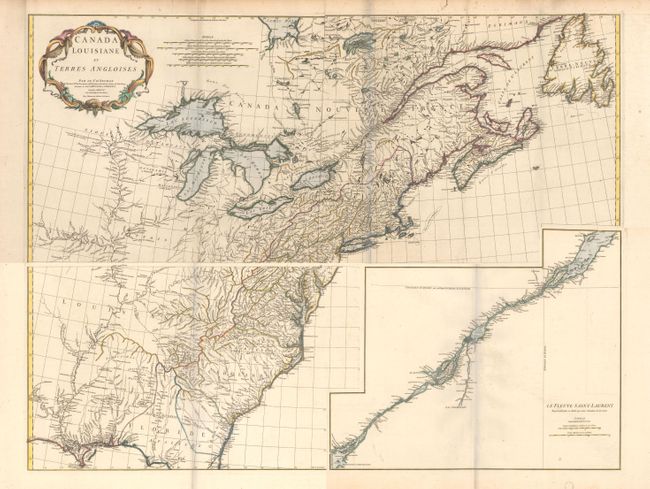
Auction 161, Lot 132
Subject: Colonial Eastern United States & Canada
Anville, Jean Baptiste Bourguignon d'
[On 4 Sheets] Canada Louisiane et Terres Angloises, 1755
Size: 44.5 x 18.8 inches (113 x 47.8 cm)
Estimate: $1,600 - $2,000
D'Anville's Spectacular Map of Eastern Seaboard
Sold for: $800
Closed on 2/8/2017
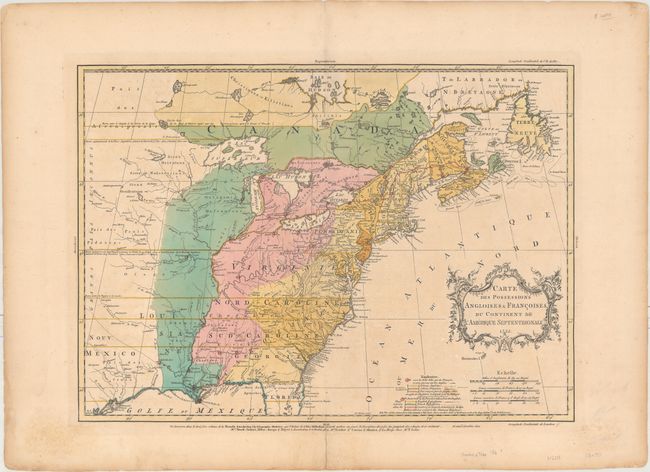
Auction 161, Lot 133
Subject: Colonial Eastern United States & Canada
Palairet, Jean
Carte des Possessions Angloises & Francoises du Continent de l'Amerique Septentrionale, 1755
Size: 22.7 x 16.4 inches (57.7 x 41.7 cm)
Estimate: $2,400 - $3,000
Important Map of French and English Territorial Claims at the Outset of the French and Indian War
Unsold
Closed on 2/8/2017
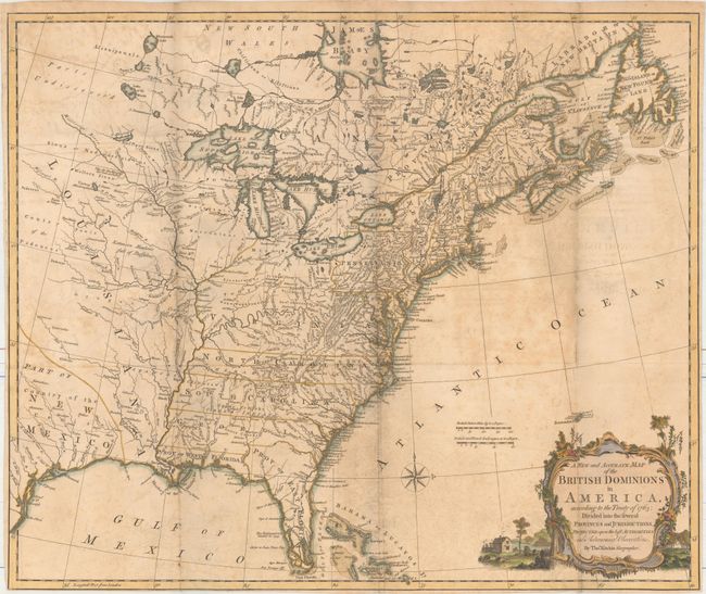
Auction 161, Lot 137
Subject: Colonial Eastern United States & Canada
Kitchin, Thomas
A New and Accurate Map of the British Dominions in America, According to the Treaty of 1763; Divided into the Several Provinces and Jurisdictions..., 1769
Size: 24.6 x 20.6 inches (62.5 x 52.3 cm)
Estimate: $1,400 - $1,700
Rare Map of the British Colonies Just After the French & Indian War
Sold for: $800
Closed on 2/8/2017
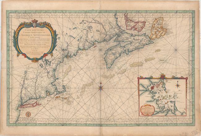
Auction 161, Lot 145
Subject: Colonial Northeastern United States & Canada
Bellin, Jacques Nicolas
Carte Reduite des Costes Orientales de l'Amerique Septentrionale 1re. Feuille Contenant l'Isle Royale, l'Accadie, la Bay Francoise, la Nouvelle Angleterre et la Nouvelle Yorc..., 1757
Size: 34.9 x 21.6 inches (88.6 x 54.9 cm)
Estimate: $1,700 - $2,000
Scarce Large-Scale Chart of the Coast of New England
Sold for: $1,200
Closed on 2/8/2017
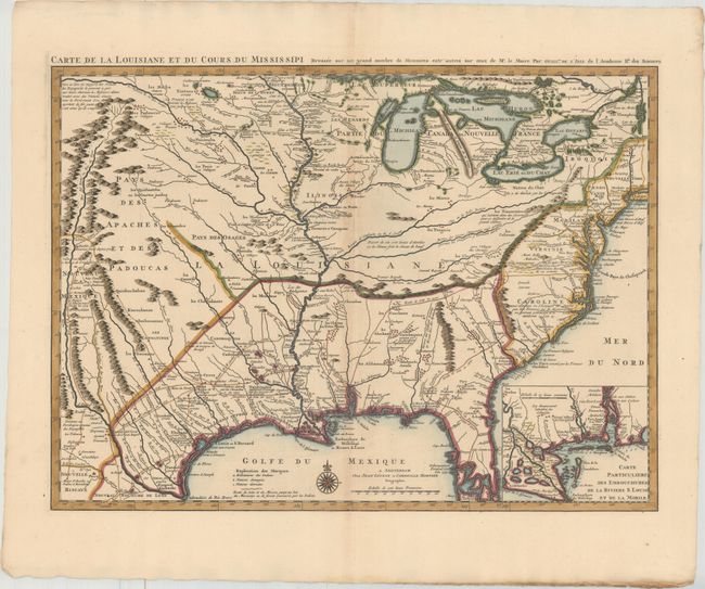
Auction 161, Lot 163
Subject: Colonial Eastern United States, Louisiana Territory
Delisle/Covens & Mortier
Carte de la Louisiane et du Cours du Mississipi Dressee sur un Grand Nombre de Memoires Entr'autres sur ceux de Mr. le Maire, 1730
Size: 23.7 x 17.3 inches (60.2 x 43.9 cm)
Estimate: $2,400 - $3,000
Delisle's Influential Map of the Louisiana Territory
Unsold
Closed on 2/8/2017
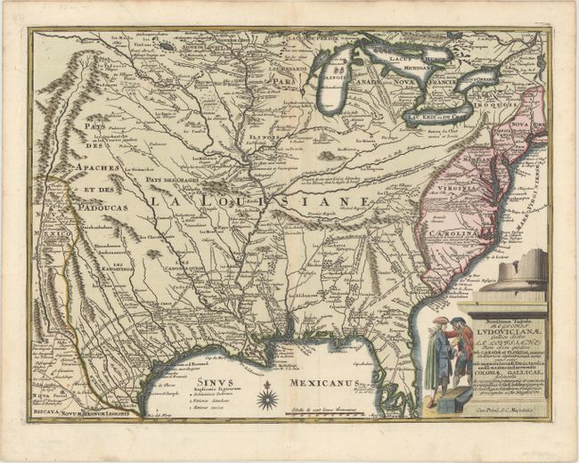
Auction 161, Lot 164
Subject: Colonial Eastern United States
Weigel, Christopher
Novissima Tabula Regionis Ludovicianae Gallice Dictae la Louisiane tam olim Quidem sub Canadae et Floridae Nomine in America Septentrionali..., 1734
Size: 16.5 x 12.5 inches (41.9 x 31.8 cm)
Estimate: $1,400 - $1,700
Uncommon Map of French Louisiana with a Title Cartouche Referencing the Mississippi Bubble Scheme
Unsold
Closed on 2/8/2017
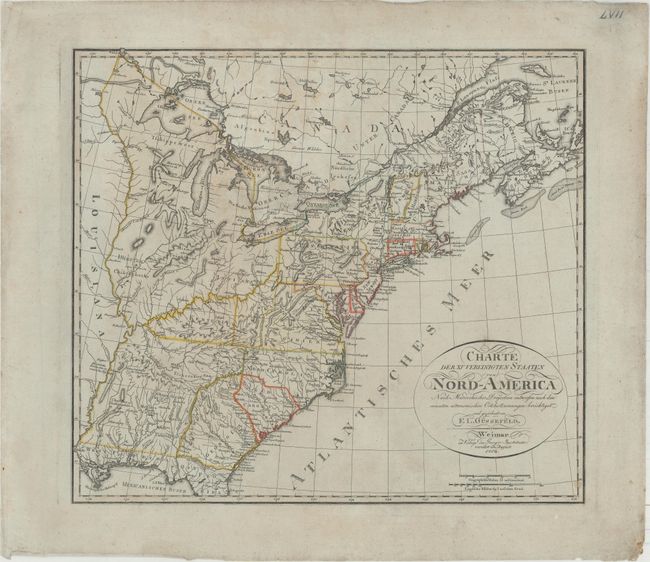
Auction 161, Lot 167
Subject: Eastern United States
Gussefeld, Franz Ludwig
Charte der XV Vereinigten Staaten von Nord-America nach Murdochischer Projection..., 1804
Size: 20.7 x 18.4 inches (52.6 x 46.7 cm)
Estimate: $1,200 - $1,500
Map Depicting the Proposed State of Franklin
Sold for: $900
Closed on 2/8/2017
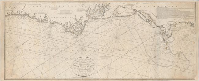
Auction 161, Lot 171
Subject: Eastern United States
Norie, John William
To the Independent Mariners of America, This Chart of their Coast from Savannah to Boston is most Respectfully Dedicated…, 1852
Size: 61 x 25.3 inches (154.9 x 64.3 cm)
Estimate: $2,000 - $2,300
Rare Blue-Back Chart of the East Coast
Unsold
Closed on 2/8/2017
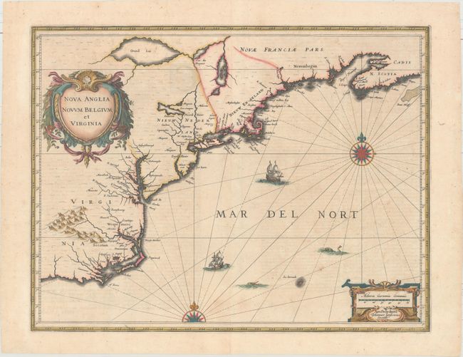
Auction 161, Lot 174
Subject: Colonial New England & Mid-Atlantic
Jansson, Jan
Nova Anglia Novum Belgium et Virginia, 1639
Size: 19.9 x 15.3 inches (50.5 x 38.9 cm)
Estimate: $1,600 - $1,900
Jansson's Influential Map of the East Coast
Sold for: $1,000
Closed on 2/8/2017
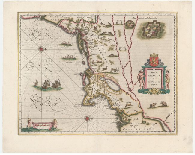
Auction 161, Lot 175
Subject: Colonial New England & Mid-Atlantic
Blaeu, Willem
Nova Belgica et Anglia Nova, 1642
Size: 19.9 x 15.3 inches (50.5 x 38.9 cm)
Estimate: $3,000 - $4,000
Important Map of Colonial New England and the Mid-Atlantic
Sold for: $2,000
Closed on 2/8/2017
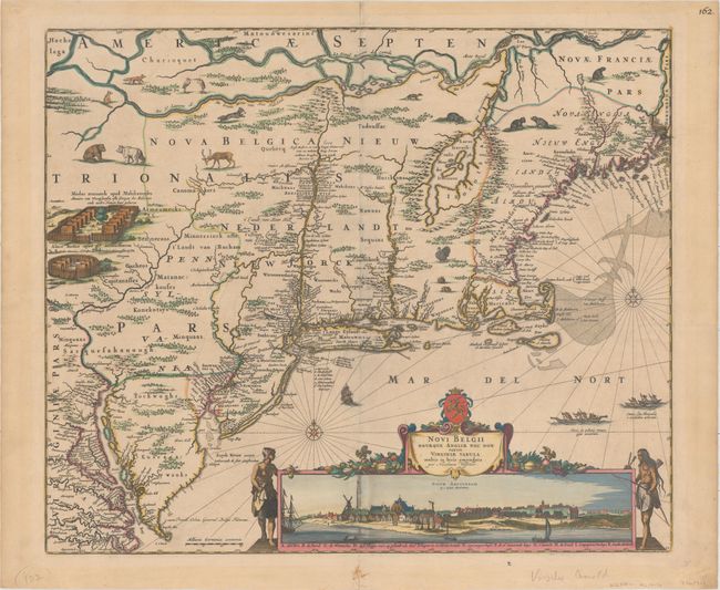
Auction 161, Lot 176
Subject: Colonial New England & Mid-Atlantic United States
Visscher, Nicolas
Novi Belgii Novaeque Angliae nec non Partis Virginiae Tabula Multis in Locis Emendata, 1684
Size: 21.9 x 18.4 inches (55.6 x 46.7 cm)
Estimate: $7,500 - $9,000
Visscher's Influential Map with Early View of New York City
Unsold
Closed on 2/8/2017
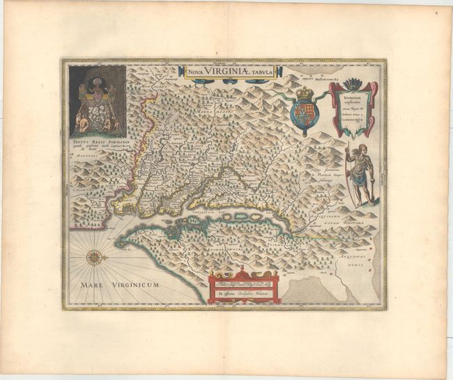
Auction 161, Lot 183
Subject: Colonial Mid-Atlantic United States
Hondius/Blaeu
Nova Virginiae Tabula, 1663
Size: 18.9 x 14.8 inches (48 x 37.6 cm)
Estimate: $2,400 - $3,000
One of the Most Important 17th Century Maps of the Chesapeake Bay in Full Original Color
Sold for: $1,400
Closed on 2/8/2017
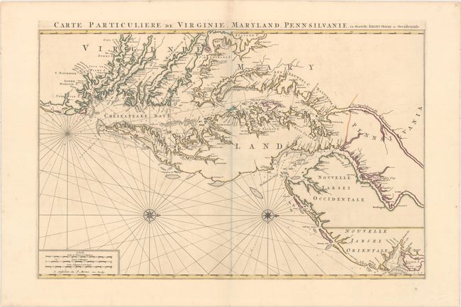
Auction 161, Lot 185
Subject: Colonial Mid-Atlantic United States
Jaillot/Mortier
Carte Particuliere de Virginie, Maryland, Pennsilvanie, la Nouvelle Iarsey. Orient et Occidentale, 1700
Size: 31.8 x 20.6 inches (80.8 x 52.3 cm)
Estimate: $6,000 - $7,500
One of the Most Beautiful Charts of Maryland and the Chesapeake Bay
Sold for: $11,000
Closed on 2/8/2017
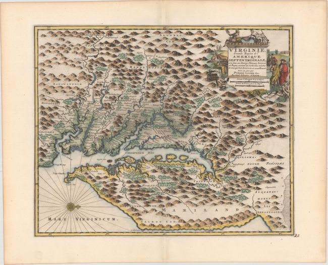
Auction 161, Lot 187
Subject: Colonial Mid-Atlantic United States
Aa, Pieter van der
Virginie, Grande Region de l'Amerique Septentrionale, avec tous Ses Bourgs, Hameaux, Rivieres et Bayes..., 1729
Size: 14.1 x 11.4 inches (35.8 x 29 cm)
Estimate: $1,800 - $2,100
Rare Derivative of John Smith's Map of the Chesapeake Bay
Unsold
Closed on 2/8/2017
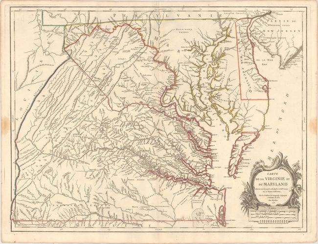
Auction 161, Lot 188
Subject: Colonial Mid-Atlantic United States
Robert de Vaugondy, Didier
Carte de la Virginie et du Maryland Dressee sur la Grande Carte Angloise de Mrs. Josue Fry et Pierre Jefferson, 1755
Size: 25.1 x 19 inches (63.8 x 48.3 cm)
Estimate: $2,400 - $3,000
First State of Robert de Vaugondy's Essential Map of Virginia and Maryland
Sold for: $1,800
Closed on 2/8/2017
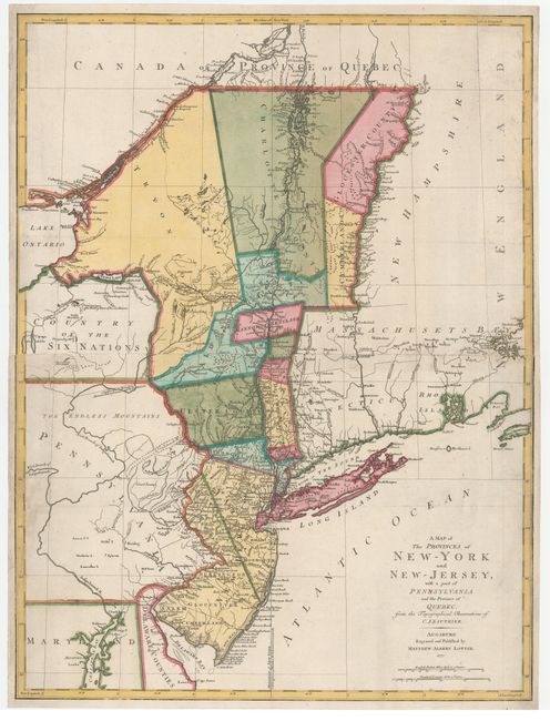
Auction 161, Lot 191
Subject: Colonial Mid-Atlantic United States
Lotter, Mathias Albrecht
A Map of the Provinces of New-York and New-Jersey, with a part of Pennsylvania and the Province of Quebec, from the Topographical Observations of C. J. Sauthier, 1777
Size: 22.1 x 29.5 inches (56.1 x 74.9 cm)
Estimate: $1,900 - $2,200
Important Revolutionary War Map
Sold for: $1,100
Closed on 2/8/2017
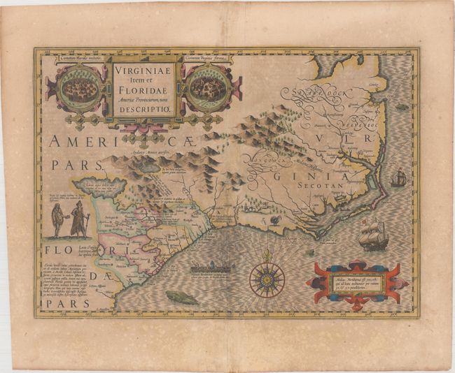
Auction 161, Lot 197
Subject: Colonial Southeast United States
Hondius, Jodocus
Virginiae Item et Floridae Americae Provinciarum, Nova Descriptio, 1619
Size: 19.1 x 13.5 inches (48.5 x 34.3 cm)
Estimate: $1,600 - $1,900
A Seminal Map of the Southeast and Early American Cartography - Full Original Color
Unsold
Closed on 2/8/2017
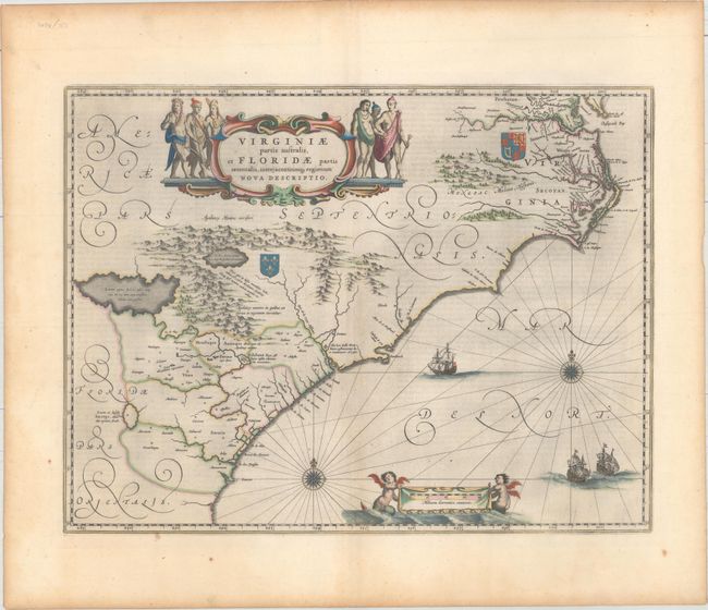
Auction 161, Lot 198
Subject: Colonial Southeast United States
Blaeu, Willem
Virginiae Partis Australis, et Floridae Partis Orientalis, Interjacentiumq Regionum Nova Descriptio, 1642
Size: 20 x 15.3 inches (50.8 x 38.9 cm)
Estimate: $1,600 - $1,900
Blaeu's Decorative Map of the Southeast in Full Original Color
Unsold
Closed on 2/8/2017
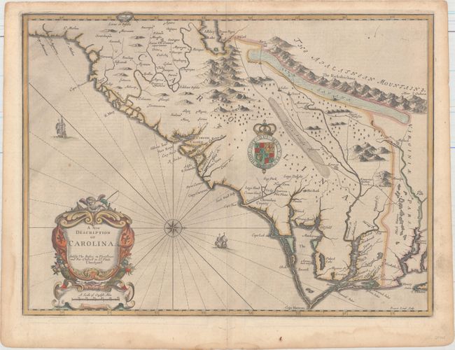
Auction 161, Lot 199
Subject: Colonial Southeastern United States
Speed/Lamb
A New Description of Carolina, 1676
Size: 20 x 14.8 inches (50.8 x 37.6 cm)
Estimate: $4,000 - $5,000
Speed's Map of the Carolinas Based Upon the Lords Proprietor's Map
Unsold
Closed on 2/8/2017
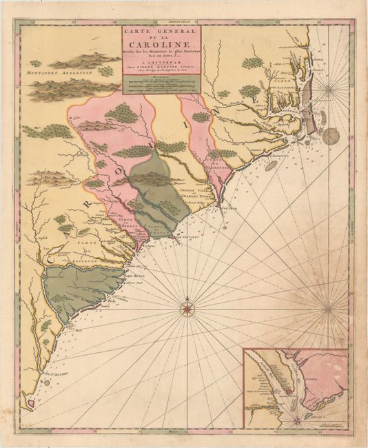
Auction 161, Lot 200
Subject: Colonial Southeast United States
Mortier, Pierre
Carte General de la Caroline. Dresse sur les Memoires le Plus Nouveaux par le Sieua S..., 1700
Size: 18.3 x 22.4 inches (46.5 x 56.9 cm)
Estimate: $1,500 - $1,800
The First Map of the Carolinas Published Outside of England
Sold for: $750
Closed on 2/8/2017
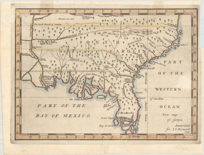
Auction 161, Lot 201
Subject: Colonial Southeast United States
Bernard, Jean Frederic
New Map of Georgia, 1737
Size: 10.3 x 7.5 inches (26.2 x 19.1 cm)
Estimate: $1,400 - $1,700
One of the Earliest Published Maps of the English Colony of Georgia
Sold for: $1,300
Closed on 2/8/2017
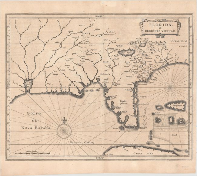
Auction 161, Lot 211
Subject: Colonial Southern United States
Gerritsz/De Laet
Florida, et Regiones Vicinae, 1630
Size: 14 x 11.3 inches (35.6 x 28.7 cm)
Estimate: $3,000 - $3,750
De Laet's Important Map of the South
Sold for: $2,200
Closed on 2/8/2017
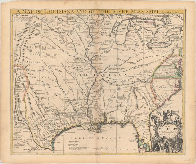
Auction 161, Lot 228
Subject: Colonial South Central United States, Louisiana
Senex, John
A Map of Louisiana and of the River Mississipi, 1721
Size: 22.8 x 19.2 inches (57.9 x 48.8 cm)
Estimate: $2,750 - $3,500
Important Map of Colonial Louisiana and the Mississippi River
Sold for: $1,800
Closed on 2/8/2017
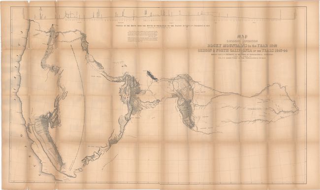
Auction 161, Lot 244
Subject: Western United States
Fremont/Preuss
Map of an Exploring Expedition to the Rocky Mountains in the Year 1842 and to Oregon & North California in the Years 1843-44 [with] Report of The Exploring Expedition to the Rocky Mountains…, 1845
Size: 51 x 30.5 inches (129.5 x 77.5 cm)
Estimate: $1,000 - $1,300
Fremont's Large Map of the American West
Unsold
Closed on 2/8/2017
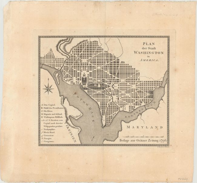
Auction 161, Lot 273
Subject: Washington, D.C.
Plan der Stadt Washington in America, 1796
Size: 9.9 x 8.4 inches (25.1 x 21.3 cm)
Estimate: $2,200 - $2,500
Extremely Rare Austrian Version of the Thackara & Vallance DC Map
Unsold
Closed on 2/8/2017
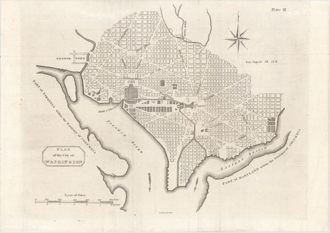
Auction 161, Lot 274
Subject: Washington, D.C.
Plan of the City of Washington, 1805
Size: 10.6 x 8.3 inches (26.9 x 21.1 cm)
Estimate: $2,000 - $2,500
Rare Second Scottish Plan of DC
Unsold
Closed on 2/8/2017
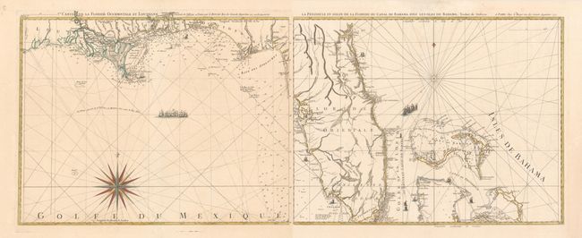
Auction 161, Lot 279
Subject: Florida
Le Rouge, George Louis
[Lot of 2] Carte de la Floride Occidentale et Louisiane [and] La Peninsule et Golfe de la Floride ou Canal de Bahama avec les Isles de Bahama, 1777
Size: 24.2 x 18.9 inches (61.5 x 48 cm)
Estimate: $1,800 - $2,100
Important Map of Florida and Its Coastlines
Unsold
Closed on 2/8/2017
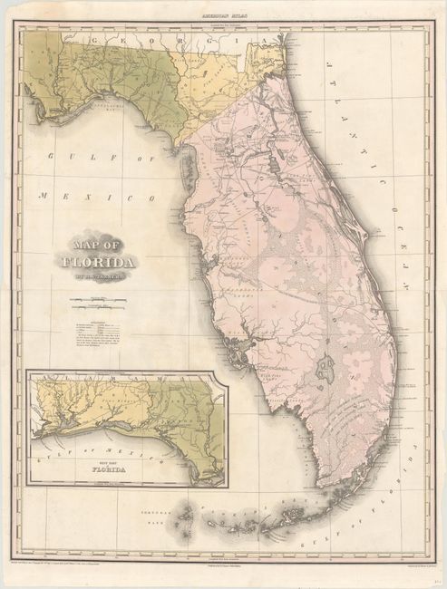
Auction 161, Lot 280
Subject: Florida
Tanner, Henry Schenck
Map of Florida, 1823
Size: 21.2 x 26.8 inches (53.8 x 68.1 cm)
Estimate: $2,000 - $2,300
Gorgeous Early Map of Florida Territory
Sold for: $2,100
Closed on 2/8/2017
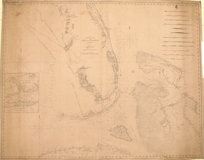
Auction 161, Lot 285
Subject: Florida, Bahamas, Cuba
Blunt, Edmund
The Bahama Banks and Gulf of Florida, 1847
Size: 48.7 x 38.7 inches (123.7 x 98.3 cm)
Estimate: $1,600 - $2,000
Impressive Blueback Chart of the Florida Keys and Dry Tortugas
Sold for: $1,200
Closed on 2/8/2017
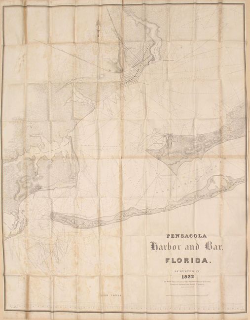
Auction 161, Lot 296
Subject: Pensacola, Florida
Kearney, James (Major)
Pensacola Harbor and Bar. Florida. Surveyed in 1822, 1822
Size: 46.6 x 57.8 inches (118.4 x 146.8 cm)
Estimate: $700 - $850
Scarce, Early Survey of Pensacola, Florida
Unsold
Closed on 2/8/2017
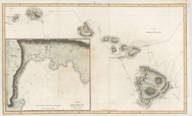
Auction 161, Lot 299
Subject: Hawaii
Cook, James (Capt.)
Chart of the Sandwich Islands, 1785
Size: 18.1 x 10.8 inches (46 x 27.4 cm)
Estimate: $800 - $950
The First Printed Map of Hawaii
Sold for: $600
Closed on 2/8/2017
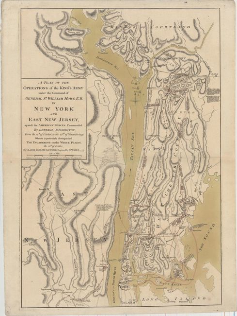
Auction 161, Lot 330
Subject: Colonial New York, Revolutionary War
Sauthier/Faden
A Plan of the Operations of the King's Army Under the Command of General Sr. William Howe, K.B. in New York and East New Jersey..., 1777
Size: 19.3 x 28.5 inches (49 x 72.4 cm)
Estimate: $10,000 - $12,000
Important Revolutionary War Map of the Battle of White Plains
Sold for: $5,000
Closed on 2/8/2017
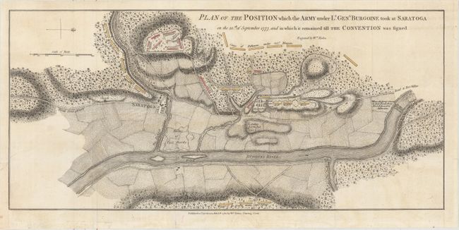
Auction 161, Lot 331
Subject: Colonial New York, Revolutionary War
Faden, William
Plan of the Position which the Army under Lt. Genl. Burgoine Took at Saratoga on the 10th of September 1777..., 1780
Size: 18.8 x 8.5 inches (47.8 x 21.6 cm)
Estimate: $1,100 - $1,400
Important Revolutionary War Map
Unsold
Closed on 2/8/2017
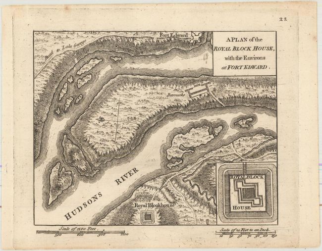
Auction 161, Lot 336
Subject: Fort Edward, New York
Rocque, Mary Ann
A Plan of the Royal Block House, with the Environs at Fort Edward, 1765
Size: 5.9 x 4.8 inches (15 x 12.2 cm)
Estimate: $900 - $1,100
Rare French & Indian War Plan of Fort Edward
Sold for: $650
Closed on 2/8/2017
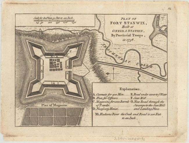
Auction 161, Lot 337
Subject: Fort Stanwix, New York
Rocque, Mary Ann
Plan of Fort Stanwix, Built at Oneida Station, by Provincial Troops, in 1758, 1765
Size: 6.4 x 4.8 inches (16.3 x 12.2 cm)
Estimate: $800 - $950
Rare French & Indian War Plan of Fort Stanwix
Sold for: $500
Closed on 2/8/2017
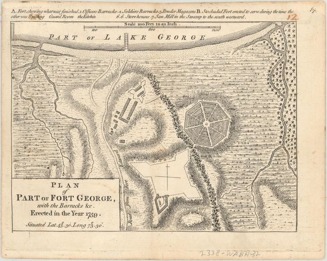
Auction 161, Lot 338
Subject: Fort George, Lake George, New York
Rocque, Mary Ann
Plan of Part of Fort George, with the Barracks &c. Erected in the Year 1759..., 1765
Size: 6.6 x 4.8 inches (16.8 x 12.2 cm)
Estimate: $900 - $1,100
Rare French & Indian War Plan of Fort George
Sold for: $650
Closed on 2/8/2017
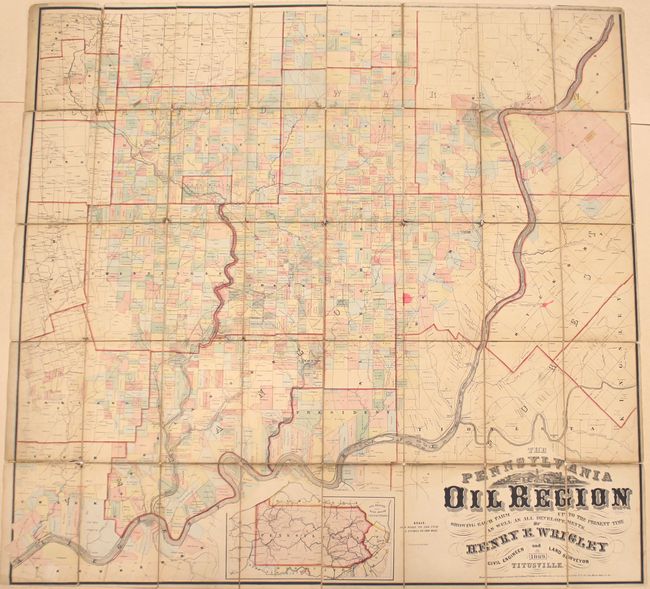
Auction 161, Lot 353
Subject: Pennsylvania
Duval, P.S. & Son
The Pennsylvania Oil Region Showing Each Farm up to the Present Time as Well as All Developements, 1869
Size: 52.4 x 49.9 inches (133.1 x 126.7 cm)
Estimate: $1,600 - $1,900
Rare Map of the Oil Region in Pennsylvania
Sold for: $2,100
Closed on 2/8/2017
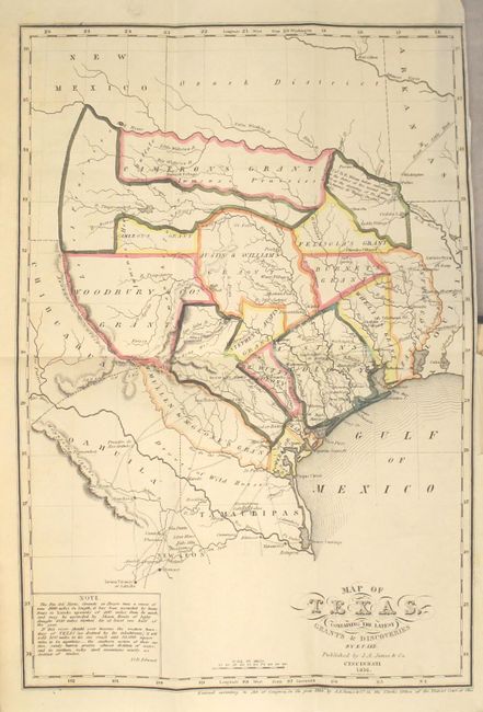
Auction 161, Lot 359
Subject: Texas
Map of Texas Containing The Latest Grants & Discoveries [bound in] The History of Texas; or, the Emigrant's, Farmer's, and Politician's Guide to the Character, Climate, Soil and Productions of That Country..., 1836
Size: 4.8 x 7.6 inches (12.2 x 19.3 cm)
Estimate: $5,500 - $7,000
Important Early Texas History with Rare Map of Republic of Texas
Sold for: $4,250
Closed on 2/8/2017
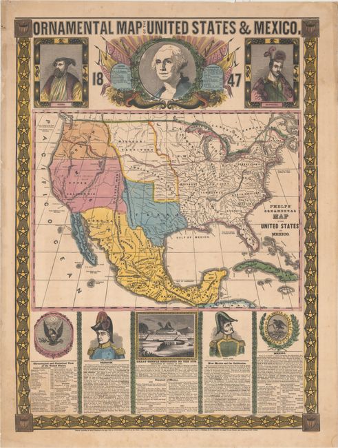
Auction 161, Lot 382
Subject: United States & Mexico
Phelps, Humphrey
Ornamental Map of the United States & Mexico, 1847
Size: 20.9 x 28.4 inches (53.1 x 72.1 cm)
Estimate: $2,000 - $2,300
Decorative Mexican-American War Map Featuring the New State of Texas
Sold for: $1,200
Closed on 2/8/2017
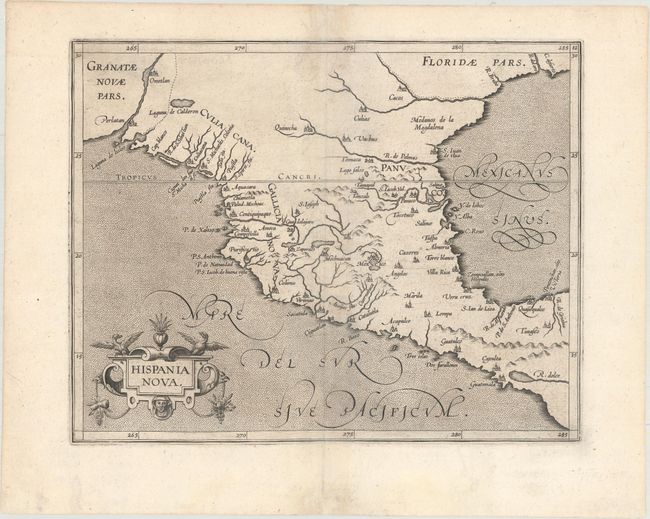
Auction 161, Lot 383
Subject: Southern United States & Mexico
Wytfliet, Cornelis
Hispania Nova, 1597
Size: 11.4 x 9 inches (29 x 22.9 cm)
Estimate: $950 - $1,200
Early Map of the American Southwest and Mexico
Sold for: $850
Closed on 2/8/2017
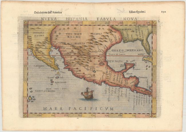
Auction 161, Lot 384
Subject: Southern United States & Mexico
Ruscelli, Girolamo
Nueva Hispania Tabula Nova, 1598
Size: 9.6 x 7.1 inches (24.4 x 18 cm)
Estimate: $1,200 - $1,500
A Foundation Map for the American Southwest
Sold for: $900
Closed on 2/8/2017
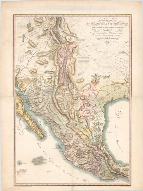
Auction 161, Lot 389
Subject: Southwestern United States & Mexico
Humboldt, Friedrich Heinrich Alexander von
Carte Generale du Royaume de la Nouvelle Espagne..., 1811
Size: 26.9 x 38.8 inches (68.3 x 98.6 cm)
Estimate: $10,000 - $13,000
Humboldt's Landmark Map of the Southwest
Sold for: $6,500
Closed on 2/8/2017
45 lots