Subject: Washington, D.C.
Period: 1805 (circa)
Publication: Encyclopaedia Perthensis
Color: Black & White
Size:
10.6 x 8.3 inches
26.9 x 21.1 cm
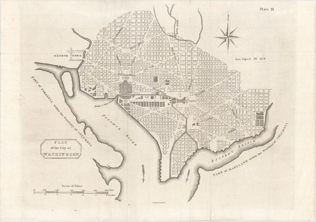
This is the second Scottish plan of Washington, DC. The plan bears some resemblance to the size and configuration of the small plans by Thackara & Vallance, Hill, and Tiebout, all of which were printed in 1792. However this plan is not a copy of any of these other plans, making it a unique addition to any collector of plans of the capital. This plan was removed from Volume 1 of the second issue of the first edition of Encyclopaedia Perthensis; or Universal Dictionary, which was published circa 1805 in Perth. This plan is also different from a larger one that was included in the first issue of the first edition of Encyclopaedia Perthensis published in 1796 in Perth. The same larger version of the plan also appeared in the 1807 London edition. It is unclear why a smaller plan was used for the second issue of the first edition, although it is possible it was done as a means to reduce costs. This same smaller plan was also included in the second edition, published in Edinburgh in 1816, however with a new imprint: Edinburgh. Printed for John Brown ... 1816. The date for this plan is given as circa 1805. Although the edition was not dated, another example of this exact map is known to have an 1805 watermark. Therefore the publication date of this map was certainly in or after 1805 but before 1816, when the imprint was changed.
Cartographically, the plan shows the layout of streets including the long diagonals, but no block numbering. Washington is bordered by the Potomak (Potomac) River and the Eastern Branch, now the Anacostia River. The proposed landscape design for the Mall is shown with only the Capitol and the Presidents House labeled. This version does not include soundings in the Potomac River, and there is no block detail in Georgetown. Decorated by a simple block-style cartouche. This map was prepared by Thomas Clerk, an engraver and lithographer in Edinburgh, who is best known for engraving John Thomson's New General Atlas in 1814. At upper right is the plate number (Plate III) and at bottom center is Clerk's imprint (T. Clerk Sculp.t Edin.r). This map is extremely rare, with only a couple of dealer listings in the last 30 years. The rarity is reinforced by the map's absence from Phillips' Maps and Views of Washington and District of Columbia.
References:
Condition: A
A nice example, issued folding, with a couple of faint spots, minor extraneous creasing, and a professionally repaired fold separation confined to the bottom blank margin.