Subject: Fort George, Lake George, New York
Period: 1765 (published)
Publication: A Set of Plans and Forts in America...
Color: Black & White
Size:
6.6 x 4.8 inches
16.8 x 12.2 cm
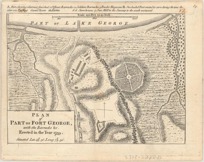
This bird's-eye plan depicts Fort George, one of 5 forts of the same name that existed in the province of New York in the 18th century. This fort was constructed under the direction of British General Jeffery Amherst in 1759 at the southern end of Lake George near Fort William Henry, which had been destroyed by the French in 1757 and abandoned. Fort George was used as a base of operations against the French Fort Carillon on Lake Champlain during the French and Indian War. This plan shows the partially built fort, the barracks, the magazine, a stockade fort that was used while the fort was still under construction, and the road to Fort Edward.
John Rocque was born Jean, the son of French Huguenot emigrant parents, who settled in London when he was quite young. Rocque is known for his survey and mapping of London, particularly the 16-sheet city plan he published in 1746, considered to be the finest depiction of London at that time. In 1751 he was appointed Chorographer to the Prince of Wales. His business was destroyed by fire in 1750, but he continued afterward and maintained the success of his business. His wife, Mary Ann Rocque, took over the business upon his death in 1762, finalizing publication of A Set of Plans and Forts in America. The work was first published in 1763, with a second edition appearing in 1765, with the only change being the addition of plate numbers. A Set of Plans and Forts in America included 30 maps and plans of important forts and other locations important during the French and Indian War, which had just concluded. Peter Andrews, also known as Pierre Andre, worked with Mary Ann Rocque and engraved some (if not all) of the plans in the work; his imprint appears on four of the plans.
References: Phillips (Atlases) #1186-18; Sellers & Van Ee #1124; Shirley (BL Atlases) T.ROCQ-2a #14.
Condition: B+
A nice impression on sturdy paper with light soiling and remnants of hinge tape on verso. There is a manuscript page number at top right just above the neatline that has offset a bit at top left.