Filtered by Category:United States(Show All Categories)
Showing results for:Auction 129
Catalog Archive
242 lots
Page 1 of 5
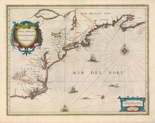
Auction 129, Lot 128
Subject: Colonial New England and Mid-Atlantic
Jansson, Jan
Nova Anglia Novum Belgium et Virginia, 1637
Size: 20 x 15.3 inches (50.8 x 38.9 cm)
Estimate: $1,900 - $2,300
Sold for: $1,400
Closed on 9/23/2009
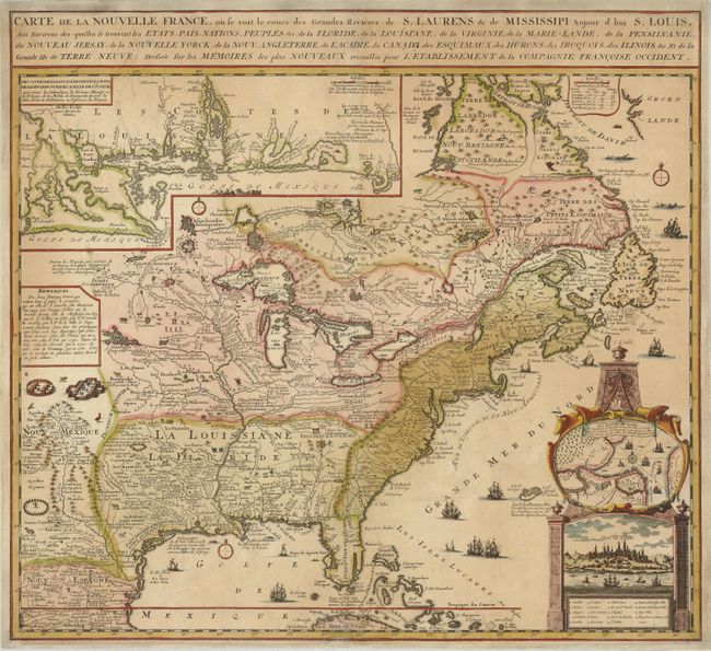
Auction 129, Lot 129
Subject: Colonial United States and Canada
Chatelain, Henry Abraham
Carte de la Nouvelle France, ou se voit le cours des Grandes Rivieres de S. Laurens & de Mississipi Aujour d'hui S. Louis, Aux Environs des-quelles se trouvent les Etats, Pais, Nations, Peuples &c., 1719
Size: 21.5 x 18 inches (54.6 x 45.7 cm)
Estimate: $1,600 - $1,800
Sold for: $1,900
Closed on 9/23/2009
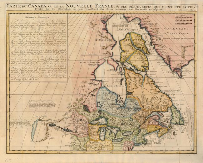
Auction 129, Lot 130
Subject: Colonial United States & Canada
Chatelain, Henry Abraham
Carte du Canada ou de la Nouvelle France, & des Decouvertes qui y ont ete Faites, Dressee sur les observations les plus Nouvelles, & sur divers Memoires tant Manuscrits qu' imprimez, 1719
Size: 20.4 x 15.8 inches (51.8 x 40.1 cm)
Estimate: $950 - $1,100
Unsold
Closed on 9/23/2009
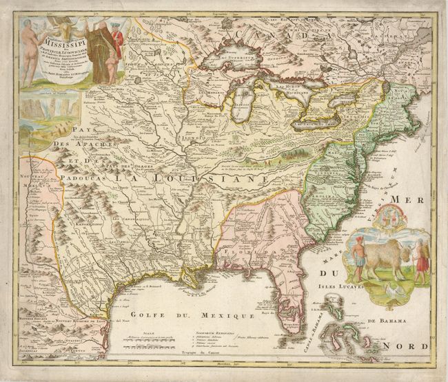
Auction 129, Lot 131
Subject: Colonial United States and Canada
Homann, Johann Baptist
Amplissimae Regionis Mississipi Seu Provinciae Ludovicianae…, 1730
Size: 22.8 x 19.3 inches (57.9 x 49 cm)
Estimate: $1,700 - $2,000
Sold for: $1,400
Closed on 9/23/2009
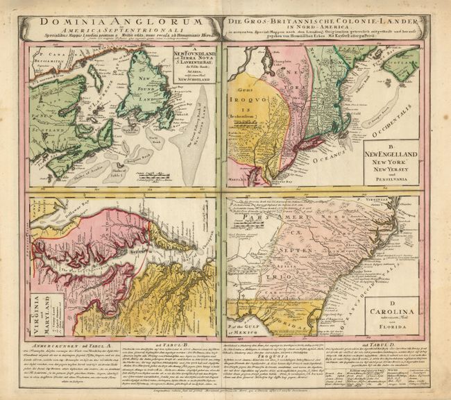
Auction 129, Lot 132
Subject: Colonial United States and Canada
Homann Heirs
Dominia Anglorum in America Septentrionali, 1740
Size: 21.8 x 19.8 inches (55.4 x 50.3 cm)
Estimate: $500 - $700
Sold for: $700
Closed on 9/23/2009
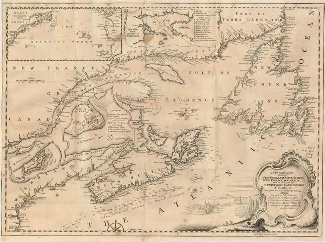
Auction 129, Lot 133
Subject: Colonial New England and Canada
Jefferys, Thomas
A New Chart of the Coast of New England, Nova Scotia, New France or Canada, with the Islands of Newfoundld. Cape Breton St. John's &c…, 1746
Size: 18.5 x 13.5 inches (47 x 34.3 cm)
Estimate: $230 - $275
Sold for: $210
Closed on 9/23/2009
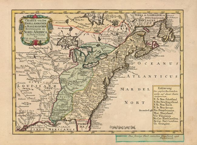
Auction 129, Lot 134
Subject: Colonial United States and Canada
Schreiber, Johann Georg
Charte von dem Engellaendischen u. Franzoesischen Besitzungen in Nord America, 1753
Size: 10 x 7 inches (25.4 x 17.8 cm)
Estimate: $475 - $550
Sold for: $350
Closed on 9/23/2009
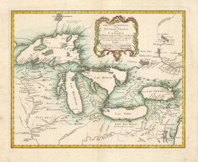
Auction 129, Lot 135
Subject: Great Lakes
Bellin/Homann Heirs
Partie Occidentale de la Nouvelle France ou du Canada, 1755
Size: 21.3 x 16.9 inches (54.1 x 42.9 cm)
Estimate: $2,100 - $2,400
Sold for: $1,300
Closed on 9/23/2009
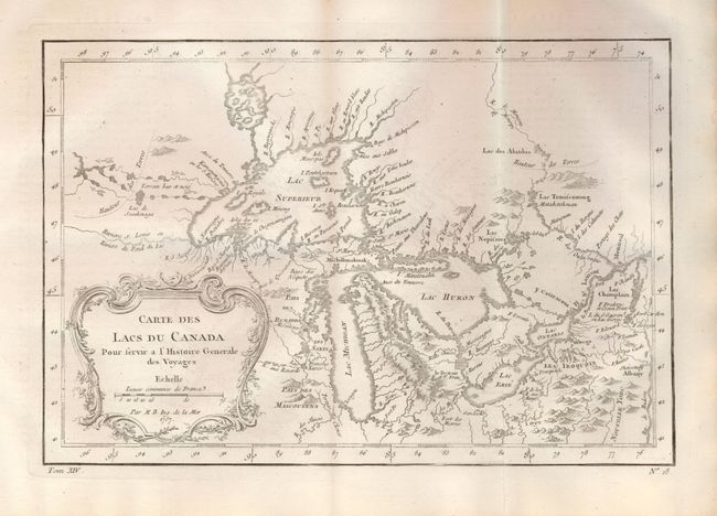
Auction 129, Lot 136
Subject: Great Lakes
Bellin, Jacques Nicolas
Carte des Lacs du Canada Pour servir a l'Histoire Generale des Voyages, 1757
Size: 11.4 x 7.6 inches (29 x 19.3 cm)
Estimate: $450 - $550
Sold for: $350
Closed on 9/23/2009
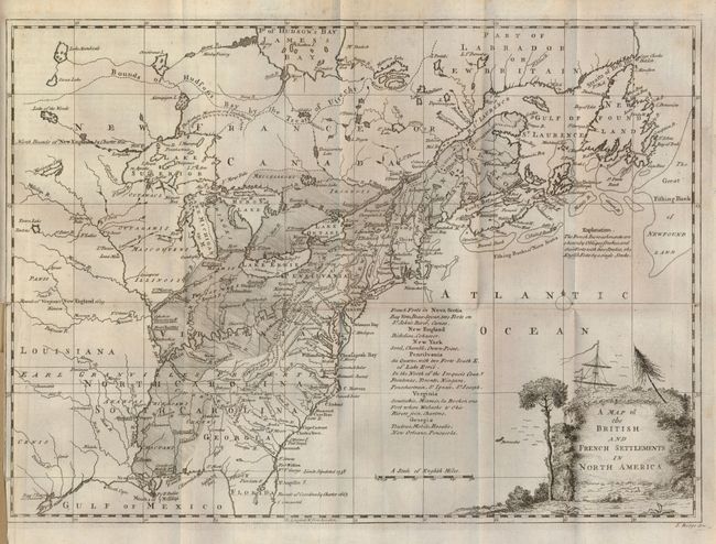
Auction 129, Lot 137
Subject: Colonial United States and Canada
Ridge, John
Map of the British and French Settlements in North America, 1758
Size: 15 x 10.8 inches (38.1 x 27.4 cm)
Estimate: $500 - $700
Sold for: $475
Closed on 9/23/2009
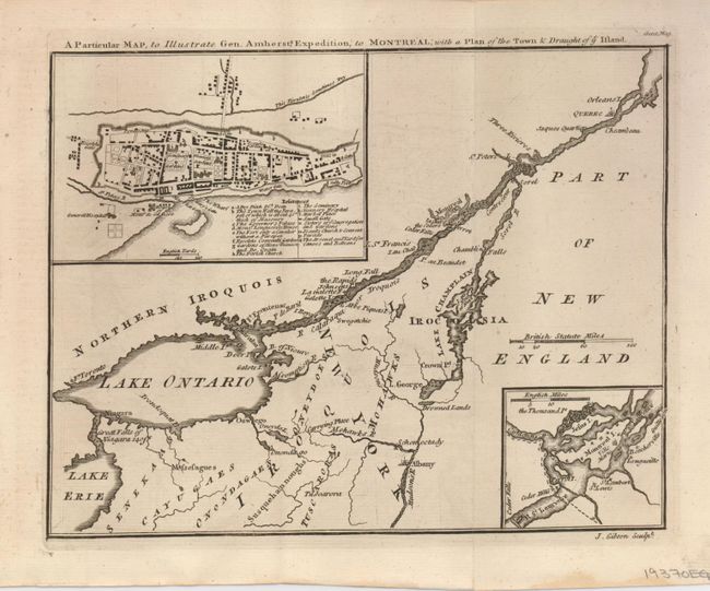
Auction 129, Lot 138
Subject: Colonial United States and Canada
Gibson, John
A Particular Map, to Illustrate Gen. Amherst's Expedition, to Montreal; with a Plan of the Town & Draught of ye Island, 1760
Size: 9 x 7 inches (22.9 x 17.8 cm)
Estimate: $160 - $220
Sold for: $140
Closed on 9/23/2009
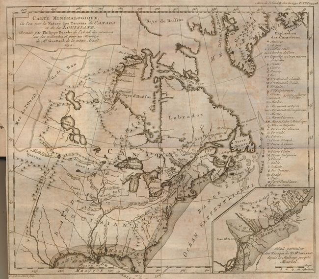
Auction 129, Lot 139
Subject: Colonial United States and Canada - Switzerland and Geology
Guettard, Jean Etienne
Carte Mineralogique, ou l'on voit la Nature des Terreins de Canada et de la Louisiane, Dressee par Philippe Buache…1752 [and] Carte Mineralogique de la Suisse par Philippe Buache pour servir aux recherches et pour un Memoire de Mr. Guettard en 1572, 1761
Size: 12 x 10.5 inches (30.5 x 26.7 cm)
Estimate: $1,000 - $1,500
Sold for: $2,100
Closed on 9/23/2009
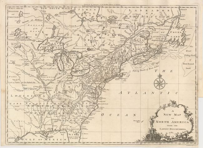
Auction 129, Lot 140
Subject: Colonial United States and Canada
Spilsbury, J.
A New Map of North America from the Latest Discoveries, 1761
Size: 14.75 x 10.9 inches (37.5 x 27.7 cm)
Estimate: $250 - $350
Sold for: $230
Closed on 9/23/2009
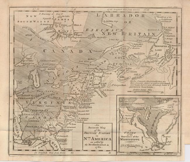
Auction 129, Lot 141
Subject: Colonial United States and Canada
Gibson, John
An Accurate Map of the British Empire in Nth. America as settled by the Preliminaries in 1762, 1762
Size: 9.5 x 8 inches (24.1 x 20.3 cm)
Estimate: $300 - $350
Sold for: $275
Closed on 9/23/2009
Auction 129, Lot 142
Subject: Colonial United States and Canada
Bonne/Lattre
[2 sheets] Partie de l'Amerique Septentrionale, qui comprend le Canada, la Louisiane, le Labrador, le Groenland, la Nouvelle Angleterre, la Florida &c., 1771
Size: 17.2 x 11.6 inches (43.7 x 29.5 cm)
Estimate: $600 - $700
Unsold
Closed on 9/23/2009
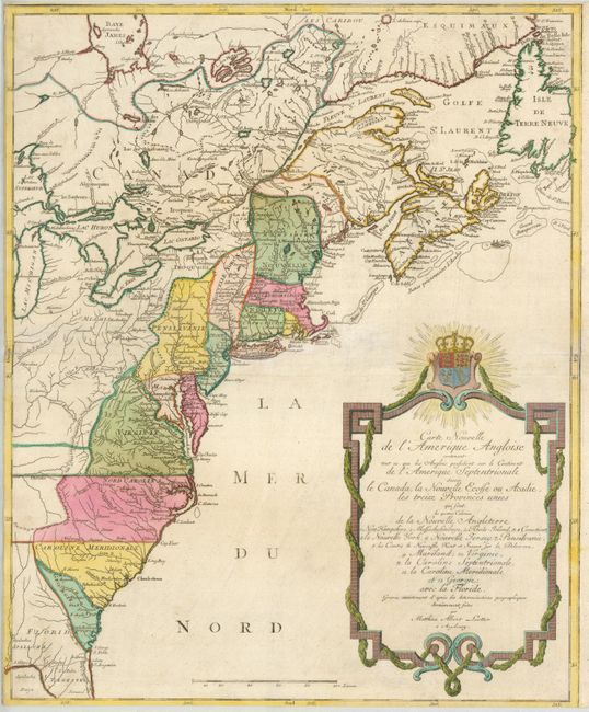
Auction 129, Lot 143
Subject: Colonial United States and Canada
Lotter, Mathias Albrecht
Carte Nouvelle de l'Amerique Angloise contenant tout ce que Anglois possedent sur le Continent de l'Amerique Septentrionale Savoir le Canada, la Nouvelle Ecosse ou Acadie, les treize Provinces Unies…, 1776
Size: 19 x 23.3 inches (48.3 x 59.2 cm)
Estimate: $800 - $900
Sold for: $700
Closed on 9/23/2009
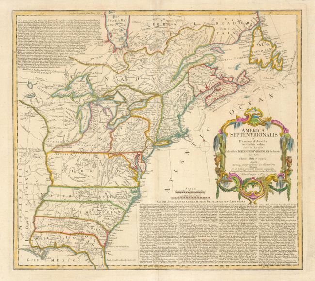
Auction 129, Lot 144
Subject: Colonial United States and Canada
Homann Heirs
America Septentrionalis a Domino d'Anville in Galliis edita nunc in Anglia Coloniis in Interiorem Virginiam deductis nec non Fluvii Ohio cursu…, 1777
Size: 20 x 18 inches (50.8 x 45.7 cm)
Estimate: $600 - $800
Sold for: $550
Closed on 9/23/2009
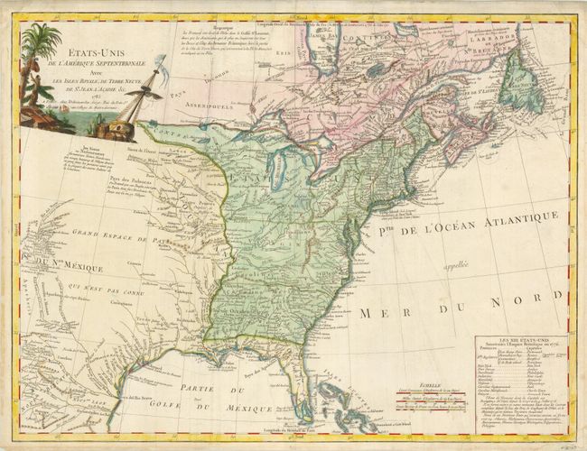
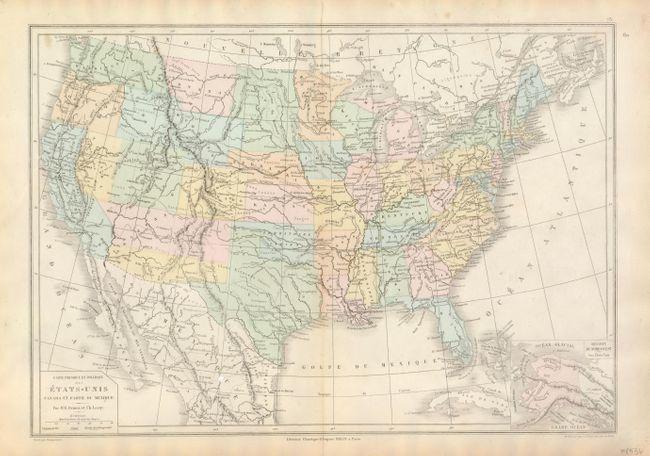
Auction 129, Lot 145
Subject: Colonial United States & Canada
Delamarche, Charles Francois
Etats-Unis de l'Amerique Septentrionale avec les Isles Royale, de Terre Neuve, de St. Jean, l'Acadie &c., 1785
Size: 25 x 18.5 inches (63.5 x 47 cm)
Estimate: $950 - $1,200
Sold for: $800
Closed on 9/23/2009
Auction 129, Lot 146
Subject: Canada & United States
Le Rouge, George Louis
Carte d'une Partie de l'Amerique Septentrionale, pour servir a l'Histoire de la derniere Guerre, 1787
Size: 19.5 x 24.2 inches (49.5 x 61.5 cm)
Estimate: $1,600 - $2,000
Unsold
Closed on 9/23/2009
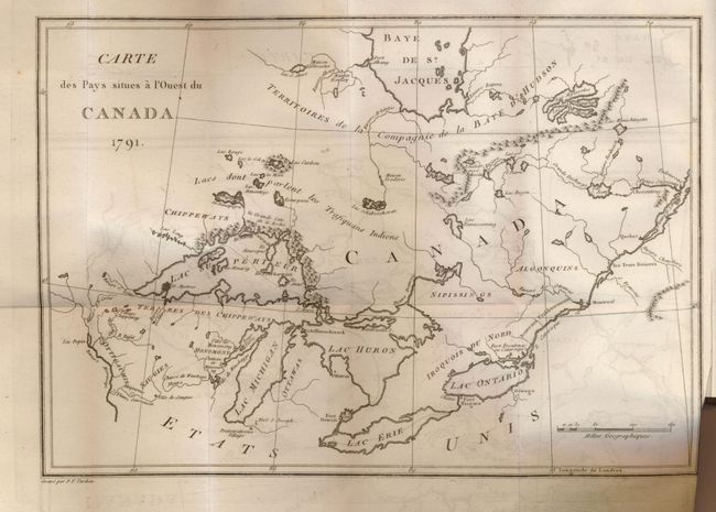
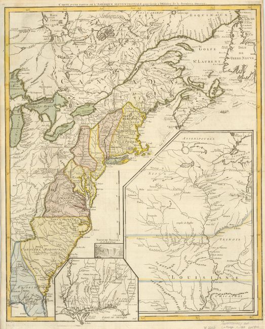
Auction 129, Lot 147
Subject: Canada & United States
Long, John
Voyages chez Differentes Nations Sauvages de l'Amerique Septentrionale [with] Carte des Pays Situes a l'Ouest du Canada 1791, 1794
Size: See Description
Estimate: $550 - $750
Sold for: $350
Closed on 9/23/2009
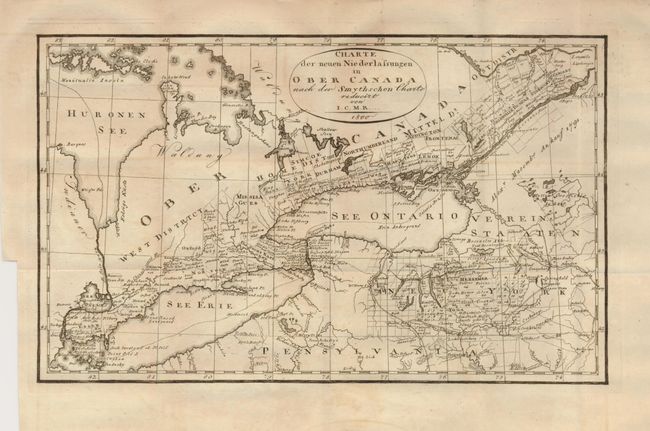
Auction 129, Lot 148
Subject: Great Lakes
I.C.M.R.
Charte der neuen Niederlassungen in Ober Canada nach der Smythschen Charte, 1800
Size: 12.3 x 7.5 inches (31.2 x 19.1 cm)
Estimate: $200 - $250
Sold for: $210
Closed on 9/23/2009
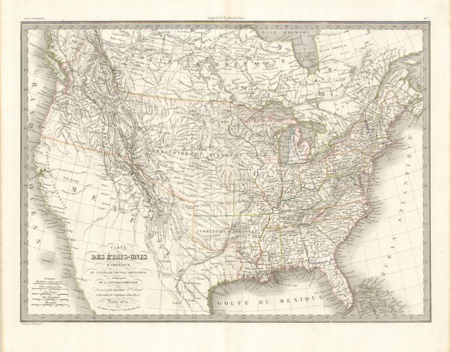
Auction 129, Lot 149
Subject: Canada & United States
Lapie, Alexander Emile & Pierre
Carte des Etats-Unis d'Amerique, du Canada, du Nouveau Brunswick et d'une partie de la Nouvelle Bretagne, 1832
Size: 21 x 15 inches (53.3 x 38.1 cm)
Estimate: $275 - $350
Sold for: $300
Closed on 9/23/2009
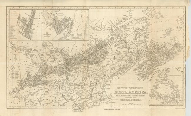
Auction 129, Lot 150
Subject: Eastern Canada & United States
Harper Bros.
British Possessions in North America with Part of the United States Compiled from Official Sources, 1843
Size: 24 x 14 inches (61 x 35.6 cm)
Estimate: $160 - $200
Sold for: $130
Closed on 9/23/2009
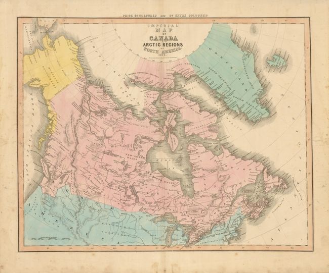
Auction 129, Lot 151
Subject: Arctic, Canada & Alaska
Caldwell, Robert
Imperial Map of Canada and Arctic Regions of North America, 1849
Size: 21.8 x 17.3 inches (55.4 x 43.9 cm)
Estimate: $140 - $180
Unsold
Closed on 9/23/2009
Auction 129, Lot 152
Subject: Western Canada and United States
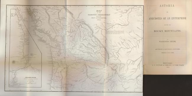
Wilkes, Charles
Map of the Oregon Territory from the Best Authorities, 1854
Size: 13 x 8 inches (33 x 20.3 cm)
Estimate: $400 - $500
Sold for: $300
Closed on 9/23/2009
Auction 129, Lot 153
Subject: Canada & New York, Niagara Falls
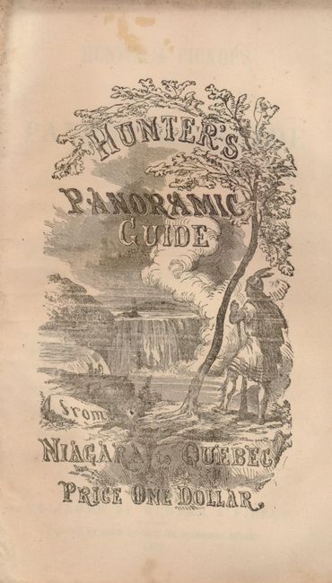
Hunter, William S.
Hunter & Pickup's Panoramic Guide from Niagara Falls to Quebec, 1866
Size: 6 x 132 inches (15.2 x 335.3 cm)
Estimate: $160 - $200
Sold for: $120
Closed on 9/23/2009
Auction 129, Lot 154
Subject: United States
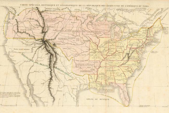
Renouard, Jules
Carte Speciale, Historique et Geographique de la Republique des Etats-Unis de l'Amerique du Nord, 1825
Size: 26 x 19 inches (66 x 48.3 cm)
Estimate: $275 - $375
Sold for: $200
Closed on 9/23/2009
Auction 129, Lot 155
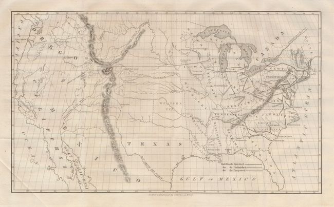
Subject: United States
[Lot of 2] [Untitled - U.S. Railroads] [and] Map of the Railroads in Whole or Part West, North, or South of the Missouri River in Which the United States Have Granted Any Loan or Credit or Subsidy in Bonds or Lands. June 30, 1883, 1846-83
Size: See Description
Estimate: $250 - $350
Sold for: $160
Closed on 9/23/2009
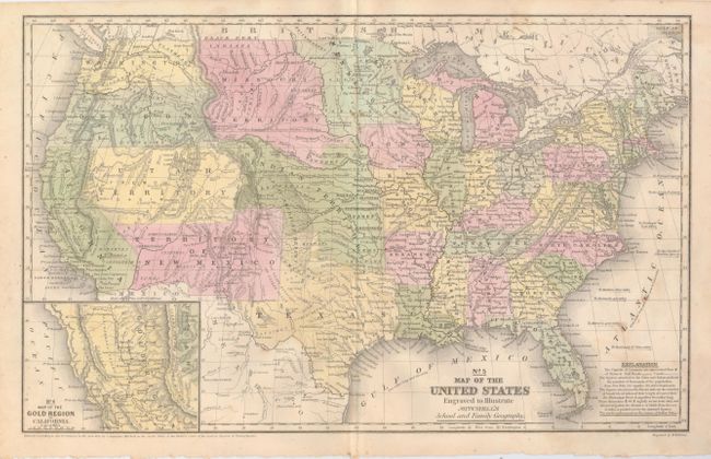
Auction 129, Lot 156
Subject: United States
Mitchell, Samuel Augustus
No. 5 Map of the United States Engraved to Illustrate Mitchell's School and Family Geography, 1852
Size: 16.7 x 10.5 inches (42.4 x 26.7 cm)
Estimate: $200 - $300
Unsold
Closed on 9/23/2009
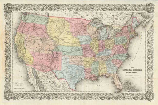
Auction 129, Lot 157
Subject: United States
Colton, Joseph Hutchins
The United States of America, 1855
Size: 26.5 x 17.5 inches (67.3 x 44.5 cm)
Estimate: $500 - $650
Sold for: $400
Closed on 9/23/2009
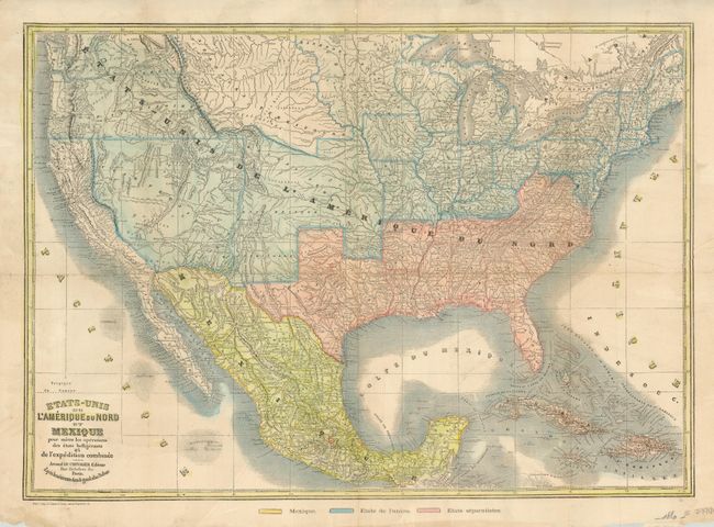
Auction 129, Lot 158
Subject: United States
Le Chevalier, Armand
Etats-Unis de l'Amerique du Nord et Mexique pour Suivre les Operations des Etats Belligerants et de l'Expedition Combinee, 1861
Size: 24 x 17 inches (61 x 43.2 cm)
Estimate: $750 - $850
Sold for: $650
Closed on 9/23/2009
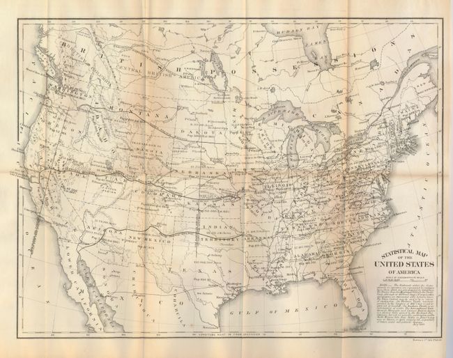
Auction 129, Lot 159
Subject: United States
U.S. Government
Statistical Map of the United States of America, 1864
Size: 19.8 x 14.8 inches (50.3 x 37.6 cm)
Estimate: $80 - $120
Sold for: $40
Closed on 9/23/2009
Auction 129, Lot 160
Subject: United States
Drioux & Leroy
[Lot of 5] Carte Physique et Politique des Etats-Unis Canada et Partie du Mexique (2) [and] Etats-Unis [and] Carte de la Partie Orientale de l'Amerique du Nord et des Antilles… [and] Etats-Unis, 1862-1898
Size: See Description
Estimate: $200 - $275
Unsold
Closed on 9/23/2009
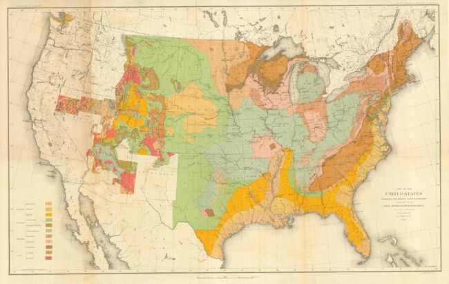
Auction 129, Lot 161
Subject: United States
U.S. Geological Survey (USGS)
Map of the United States Exhibiting the Present Status of Knowledge Relating to the Areal Distribution of Geologic Groups, 1884
Size: 28 x 17.3 inches (71.1 x 43.9 cm)
Estimate: $200 - $250
Sold for: $300
Closed on 9/23/2009
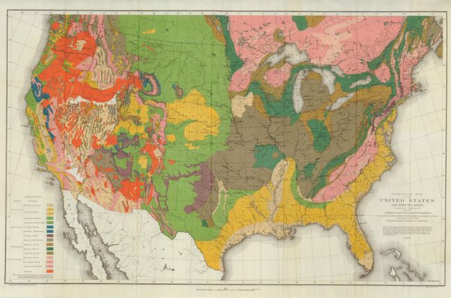
Auction 129, Lot 162
Subject: United States
Hitchcock, Charles Henry
Geological Map of the United States and Part of Canada Compiled by C.H. Hitchcock for the American Institute of Mining Engineers to Illustrate the Schemes of Coloration and Nomenclature Recommended by the International Geological Congress, 1886
Size: 27.8 x 17.3 inches (70.6 x 43.9 cm)
Estimate: $300 - $400
Sold for: $425
Closed on 9/23/2009
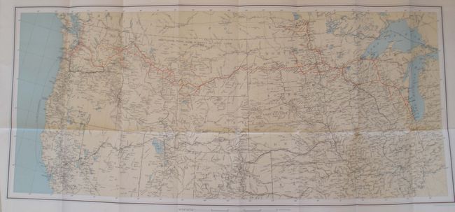
Auction 129, Lot 163
Subject: United States
Railroad Companies, (Various)
Northern Pacific Railroad. Report of the Board of Directors to the Stockholders at their Annual Meeting, October 16th, 1890. [with Untitled - Map of the Western U.S.], 1890
Size: 27.8 x 12.5 inches (70.6 x 31.8 cm)
Estimate: $90 - $120
Sold for: $50
Closed on 9/23/2009
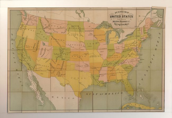
Auction 129, Lot 164
Subject: United States
[Lot of 3 U.S. Puzzles], 1890-1915
Size: See Description
Estimate: $200 - $400
Sold for: $190
Closed on 9/23/2009
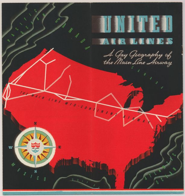
Auction 129, Lot 165
Subject: United States
United Air Lines A Gay Geography of the Main Line Artery, 1937
Size: 20 x 10.5 inches (50.8 x 26.7 cm)
Estimate: $120 - $160
Sold for: $170
Closed on 9/23/2009
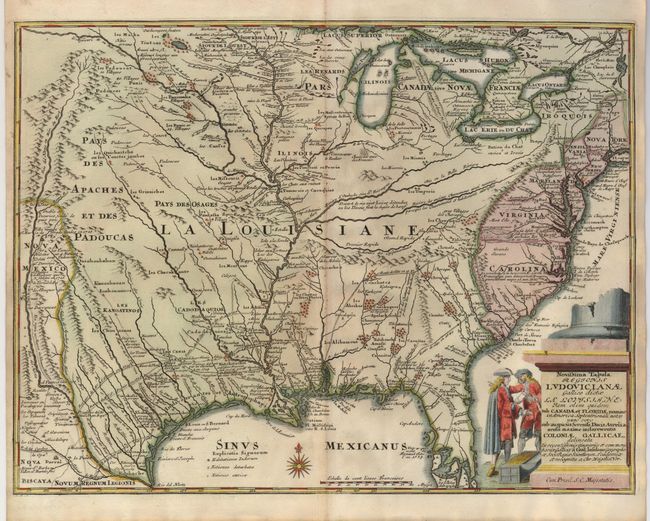
Auction 129, Lot 166
Subject: Colonial United States
Weigel, Christopher
Novissima Tabula Regionis Ludovicianae Gallice dicta la Louisiane…, 1734
Size: 16.3 x 12.5 inches (41.4 x 31.8 cm)
Estimate: $1,200 - $1,400
Sold for: $1,300
Closed on 9/23/2009
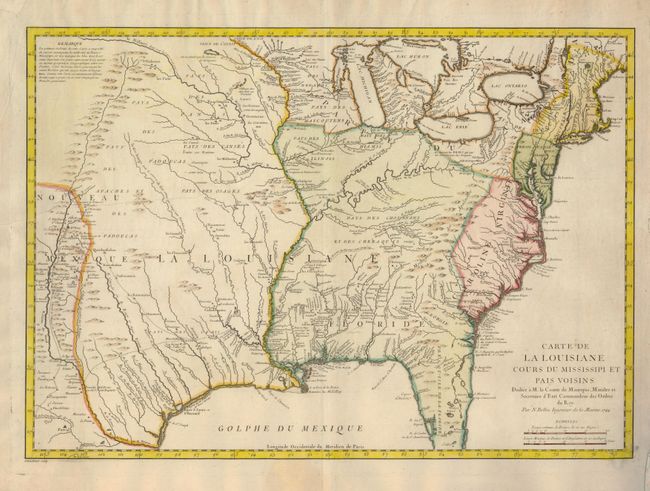
Auction 129, Lot 167
Subject: Colonial United States
Bellin, Jacques Nicolas
Carte de la Louisiane Cours du Mississipi et Pais Voisins…, 1744
Size: 22 x 15.5 inches (55.9 x 39.4 cm)
Estimate: $1,000 - $1,300
Sold for: $800
Closed on 9/23/2009
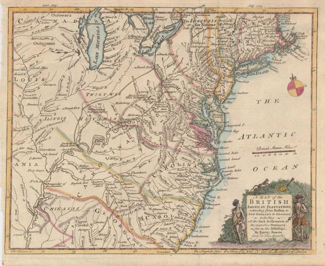
Auction 129, Lot 168
Subject: Colonial United States
Bowen, Emanuel
A Map of the British American Plantations extending from Boston in New England to Georgia; including all the back Settlements in the respective Provinces, as far as the Mississipi, 1754
Size: 10.8 x 8.6 inches (27.4 x 21.8 cm)
Estimate: $500 - $600
Sold for: $375
Closed on 9/23/2009
Auction 129, Lot 169
Subject: Colonial United States
Gibson, John
[Louisiana and British Colonies in North America], 1763
Size: 9.5 x 7 inches (24.1 x 17.8 cm)
Estimate: $250 - $300
Sold for: $180
Closed on 9/23/2009
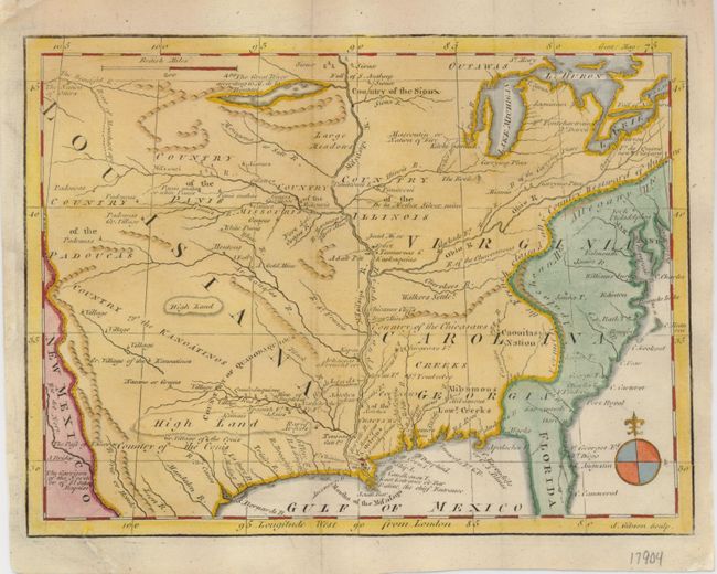
Auction 129, Lot 170
Subject: Eastern United States
Brion de la Tour, Louis
Carte des Etats-Unis d'Amerique et du Cours du Mississipi…, 1784
Size: 27.5 x 20 inches (69.9 x 50.8 cm)
Estimate: $3,000 - $3,750
Sold for: $1,800
Closed on 9/23/2009
Auction 129, Lot 171
Subject: Eastern United States
Tardieu, Pierre Francois
Carte Generale des Etats-Unis de l'Amerique Septentrionale, Renfermant Aussi quelques Provinces Angloises adjacentes…, 1787
Size: 16.5 x 10 inches (41.9 x 25.4 cm)
Estimate: $300 - $400
Sold for: $230
Closed on 9/23/2009
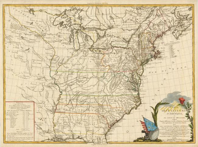
Auction 129, Lot 172
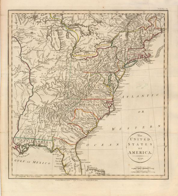
Subject: Eastern United States
Payne, John
The United States of America, 1791
Size: 13.5 x 14.5 inches (34.3 x 36.8 cm)
Estimate: $700 - $1,000
Sold for: $950
Closed on 9/23/2009
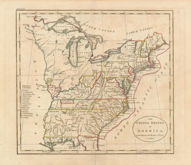
Auction 129, Lot 173
Subject: Eastern United States, Texas
[Lot of 2] The United States of America, according to the Treaty of Peace of 1784 [and] United States of America, 1795-1838
Size: See Description
Estimate: $200 - $275
Sold for: $230
Closed on 9/23/2009
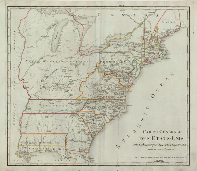
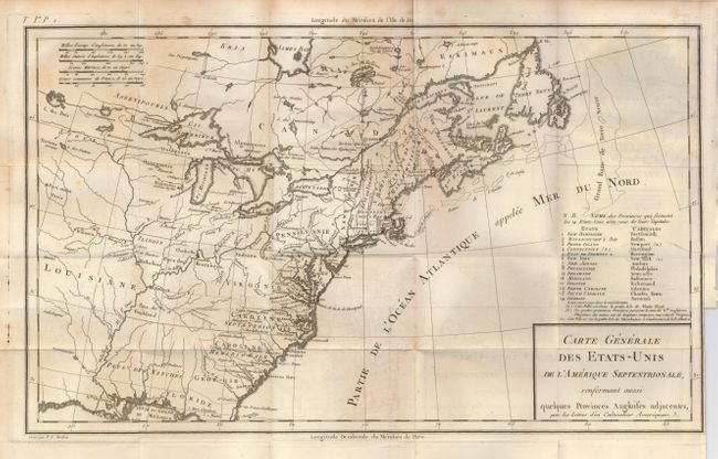
Auction 129, Lot 174
Subject: Eastern United States
Rochefoucald Liancourt, Francois Alexander
Carte Generale des Etats-Unis de l'Amerique Septentrionale Divisee en ses 17 Provinces, 1800
Size: 17.8 x 15.5 inches (45.2 x 39.4 cm)
Estimate: $400 - $500
Sold for: $425
Closed on 9/23/2009
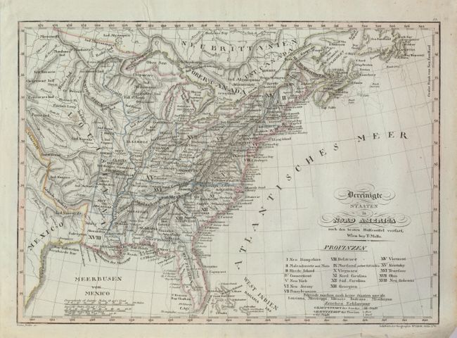
Auction 129, Lot 175
Subject: Eastern United States
Mollo, Tranquillo
Vereinigte Staaten in Nord America nach den Besten Hulfsmittel Verfast, 1800
Size: 17.5 x 12.5 inches (44.5 x 31.8 cm)
Estimate: $350 - $425
Sold for: $250
Closed on 9/23/2009
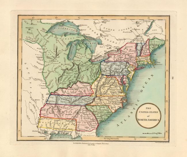
Auction 129, Lot 176
Subject: Eastern United States
Laurie & Whittle
The United States of North America, 1801
Size: 9.4 x 7.8 inches (23.9 x 19.8 cm)
Estimate: $250 - $300
Sold for: $300
Closed on 9/23/2009
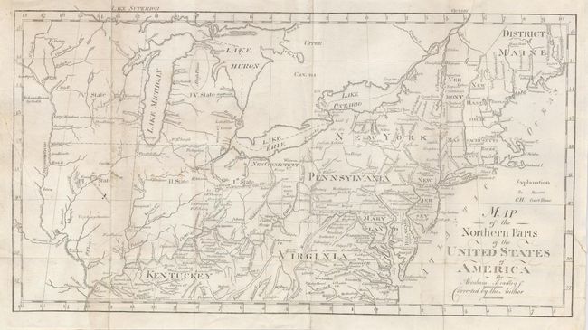
Auction 129, Lot 177
Subject: Eastern United States
Bradley, Abraham Jr.
Map of the Northern Parts of the United States of America by Abraham Bradley Jr. Corrected by the Author, 1802
Size: 15 x 8 inches (38.1 x 20.3 cm)
Estimate: $190 - $240
Sold for: $150
Closed on 9/23/2009
242 lots
Page 1 of 5