Subject: Eastern United States, Texas
Period: 1795-1838 (circa)
Publication:
Color: Hand Color
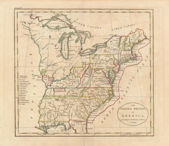
1) The United States of America, according to the Treaty of Peace of 1784, John C. Russell, London, c. 1795, (8 x 7"). A very early map that details the fledgling states and the Indian lands east of the Mississippi River. The map is particularly interesting for the depiction of the Revolutionary War Bounty Land Grants. Ohio is a small area labeled Ohio Company and Donation Lands with no sign of the other bounty grants named on Russell's larger, derivative map. Other interesting designations west of Ohio bear the labels Illinois Company, Wabash Company, Army Lands, and New Jersey Company. The area northeast of the upper Mississippi River is largely unorganized with a few rivers, forts and settlements; Detroit, the Lake of the Woods, and Upper and Lower Iowa are in this region. Army Lands are located in both Kentucky (unnamed) and in the Tennessee Government. Tennessee had recently split from western North Carolina and would soon gain statehood. Georgia is listed as the fifteenth state and appears to extend to the Mississippi River. Florida is divided into east and west regions. Under the control of Spain, Florida had been ceded by England to the Spanish in gratitude for their neutrality during the American Revolutionary War. Various Indian tribes, forts, and villages are indicated throughout. The Twenty Leagues Line is drawn in the Atlantic. Near the left margin is the "References to the States," listing only fifteen. The title misdates the Treaty of Paris to 1784, instead of 1783. There is slight toning in the Atlantic and a short centerfold split into border at bottom that is closed on verso with old tape repair (B+).
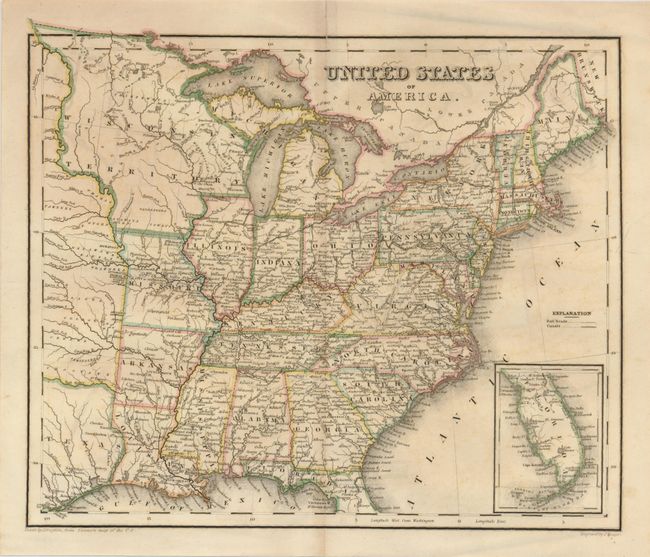
2) United States of America, John Drayton, 1838, (10.5 x 9"). This map was drawn by Drayon "from Tanner's map of the U.S." and the copper plate was engraved by J. Yeager. The map extends to include about half of the Independent Republic of Texas. The map shows a large Wisconsin Territory, Missouri, Arkansas, and Louisiana. The inset continues the lower half of Florida on the same scale. The map provides excellent detail throughout with a finely engraved line. The slight offsetting in the Atlantic is not distracting (A).
References: 1) McCorkle #795-11.
Condition:
See individual descriptions.