Subject: Eastern United States
Period: 1791 (dated)
Publication: Universal Geography
Color: Hand Color
Size:
13.5 x 14.5 inches
34.3 x 36.8 cm
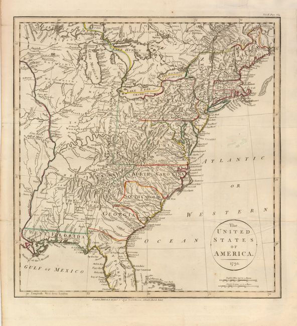
This is an apparently unrecorded map that shows Frankland, the proposed state that is also known as Franklinia. The map was published during a tumultuous political period in the United States. There were several political movements to organize new states on the western frontier, one of which was to be named in honor of Benjamin Franklin. This proposed state was to be formed in the region that eventually became eastern Tennessee. The map also shows Kentucky, A New State running along a north-south line forming a western border of Virginia and Pennsylvania. There are two other notations of A New State; one in present-day Ohio, and the other roughly in Indiana. The map is filled with Indian villages and interesting remarks, such as Country full of Mines and Mascoutens Nation of the Fire. Publisher's imprint beneath bottom neatline, London, Published August 1st 1791 by J. Johnson, St. Paul's Church Yard.
The ephemeral state of Frankland appeared on only a small number of maps from 1785 to the early part of the 19th century. Ashley Bayton-Williams wrote an article for the Map Collector (Vol. 72, 1995) listing the known maps that showed it. This map is not listed there, nor in any other reference or checklist of early maps of the United States. It also has not appeared in any dealer or auction catalog records that we can find.
References:
Condition: A
Nice impression and original outline color. Issued folding, with a few creases and a few stray spots of color in the Atlantic. The binding trim in the top margin has been replaced to better accommodate framing.