Subject: United States
Period: 1846-83 (dated)
Publication:
Color:
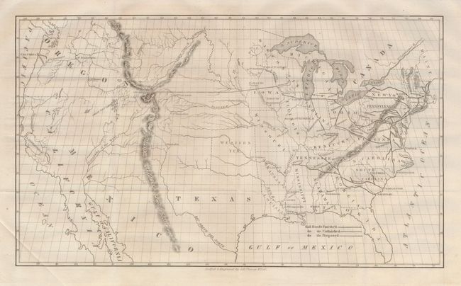
1) O.H. Throop, 1846, (16 x 9"), Senate Doc. 29th Congress, 1st Session. This map of the United States shows the existing (finished and unfinished) railroads in the eastern states with a proposed railroad shown beginning at Prairie du Chin and stretching toward the Pacific through South Pass. The map portrays the United States prior to the acquisition of California and the Southwest, with a large Oregon Territory and the new state of Texas in a very large, transitional configuration. The map, engraved by O.H. Throop, was issued in "Memorial of A. Whitney Praying a grant of public land to enable him to construct a railroad from lake Michigan to the Pacific Ocean". Asa Whitney was one of the first backers of an American Transcontinental Railway; as early as 1830 Whitney became enthralled with railroads and foresaw their future role in business and transport. Whitney's proposed route from Lake Michigan through South Pass to the Pacific was not accepted mainly because of the growing sectionalism before the Civil War. However, the map and report are an important part of the railroad history of the United States. Folding as issued with strong impression.
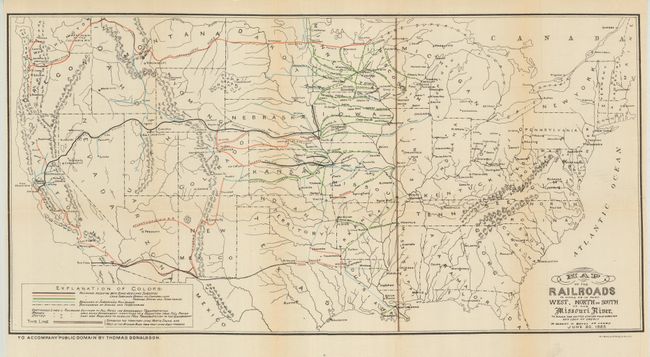
2) Map of the Railroads in Whole or Part West, North, or South of the Missouri River in Which the United States Have Granted Any Loan or Credit or Subsidy in Bonds or Lands. June 30, 1883, Thomas Donaldson, 1883, (25 x 14"), printed color. This map of the United States is one of Donaldson's controversial maps, which became a political issue in the election of 1884. Color coding identifies the railroads that are receiving subsidies (either Bond or land, or both) and branch railroads. Different line forms are used to indicate what fees the railroads may charge the government for freight hauled: full rates, reduced rates, and those that must provide free transportation for the U.S. Government. Very nice example with a short closed tear at left.
References:
Condition: A
See individual descriptions.