Subject: Eastern United States
Period: 1802 (published)
Publication: Morse's American Universal Geography
Color: Black & White
Size:
15 x 8 inches
38.1 x 20.3 cm
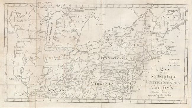
This is an interesting and significant map that shows Ohio, Indiana, Illinois, Michigan and Wisconsin referred to, respectively, as State I, II, III, IV, and V. These are the five new states as proposed in the Ordinance of 1789. The northern boundaries of Illinois, Indiana and Ohio are shown at the southern tip of Lake Michigan. The positioning of this line later resulted in a boundary dispute between Michigan and Ohio, with Ohio blocking admission of Michigan to the Union until the question was settled. Fighting was considered a real possibility in this heated dispute. The mostly blank Wisconsin bears the notation "Large Meadows extending to Lake Michigan." Wisconsin came from the term "Ouisconsin" that is believed to mean "grassy place" in the Chippewa language. The Western Reserve is inscribed "New Connecticut." Wayne County is the only county shown in Michigan. Cincinnati is here called Cincinnatus. Map locates portages, Musquito Fort, to name one of many forts, plus watershed, frontier villages, and much more deserving of study. The boundary line from Gen. Wayne's Treaty of 1795 is shown. Maine is the District of Maine. The map extends to the Mississippi River with the lands to the west "Re Lands Reserved by the US." This map appears identical to the first edition of 1797 save for the corrected statement in the title and the lack of Callender noted as the engraver. A scarce issue.
References: Wheat & Brun #158.
Condition: B
Issued folding with some weakness at folds. Some soiling at left, a short tear at bottom, another at right, both closed on verso, and a small slice near Albany also closed on verso. The map shows much better than this critical description suggests.