Filtered by Category:United States(Show All Categories)
Showing results for:Auction 127
Catalog Archive
238 lots
Page 1 of 5
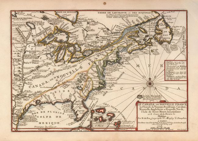
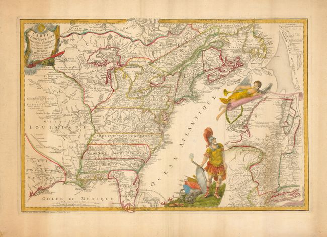
Auction 127, Lot 124
Subject: Colonial United States and Canada
Fer, Nicolas de
Le Canada, ou Nouvelle France, la Floride, la Virginie, Pensilvanie, Caroline, Nouvelle Angleterre et Nouvelle Yorck, l'Isle de Terre Neuve, la Louisiane et le cours de la Riviere de Misisipi, 1705
Size: 13.5 x 9 inches (34.3 x 22.9 cm)
Estimate: $800 - $950
Sold for: $600
Closed on 2/25/2009
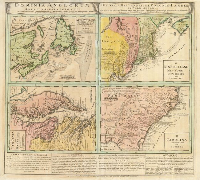
Auction 127, Lot 126
Subject: Colonial United States and Canada
Homann Heirs
Dominia Anglorum in America Septentrionali, 1740
Size: 21.8 x 19.8 inches (55.4 x 50.3 cm)
Estimate: $550 - $650
Sold for: $400
Closed on 2/25/2009
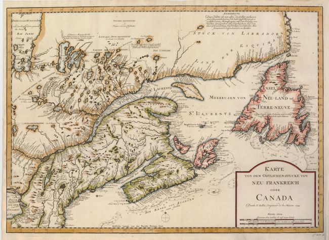
Auction 127, Lot 127
Subject: Colonial New England and Canada
Bellin, Jacques Nicolas
Karte von dem Ostlichen-Stucke von Neu Frankreich oder Canada, 1744
Size: 22 x 15.5 inches (55.9 x 39.4 cm)
Estimate: $400 - $475
Sold for: $375
Closed on 2/25/2009
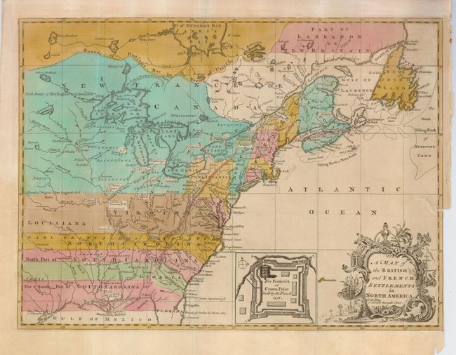
Auction 127, Lot 128
Subject: Colonial United States and Canada
Hinton, John
A Map of the British and French Settlements in North America, 1755
Size: 14.8 x 10.8 inches (37.6 x 27.4 cm)
Estimate: $550 - $650
Sold for: $600
Closed on 2/25/2009
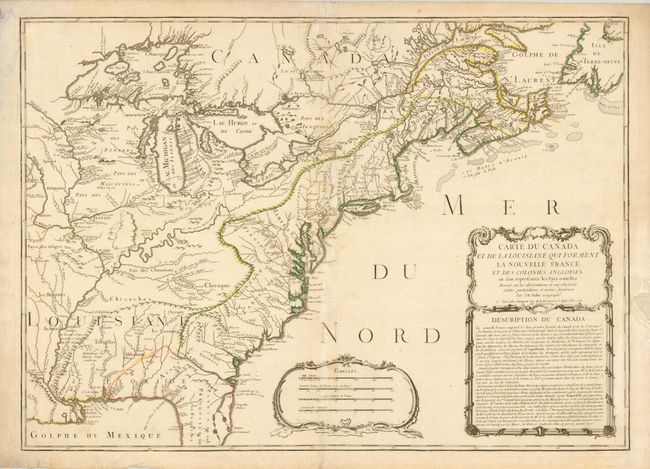
Auction 127, Lot 129
Subject: Colonial United States and Canada
Nolin, Jean Batiste
Carte du Canada et de la Louisiane qui Forment la Nouvelle France et des Colonies Angloises…, 1756
Size: 28 x 19.8 inches (71.1 x 50.3 cm)
Estimate: $2,400 - $3,000
Unsold
Closed on 2/25/2009
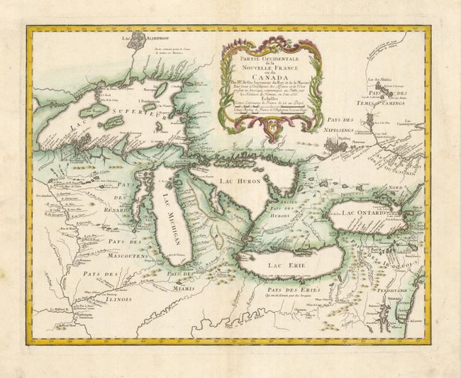
Auction 127, Lot 130
Subject: Great Lakes
Bellin/Homann Heirs
Partie Occidentale de la Nouvelle France ou du Canada, 1755
Size: 21.3 x 16.9 inches (54.1 x 42.9 cm)
Estimate: $2,100 - $2,400
Unsold
Closed on 2/25/2009
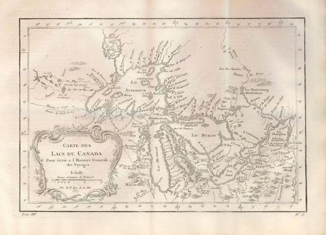
Auction 127, Lot 131
Subject: Great Lakes
Bellin, Jacques Nicolas
Carte des Lacs du Canada Pour servir a l'Histoire Generale des Voyages, 1757
Size: 11.4 x 7.6 inches (29 x 19.3 cm)
Estimate: $600 - $800
Unsold
Closed on 2/25/2009
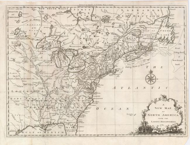
Auction 127, Lot 132
Subject: Colonial United States and Canada
Spilsbury, J.
A New Map of North America from the Latest Discoveries, 1761
Size: 14.75 x 10.9 inches (37.5 x 27.7 cm)
Estimate: $200 - $250
Sold for: $325
Closed on 2/25/2009
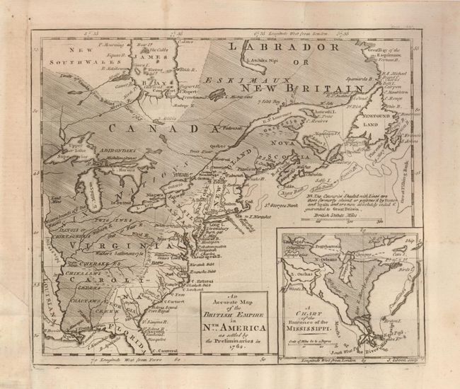
Auction 127, Lot 133
Subject: Colonial United States and Canada
Gibson, John
An Accurate Map of the British Empire in Nth. America as Settled by the Preliminaries in 1762, 1762
Size: 9.5 x 8.2 inches (24.1 x 20.8 cm)
Estimate: $350 - $400
Sold for: $400
Closed on 2/25/2009
Auction 127, Lot 134
Subject: Colonial United States and Canada
Beaurain, Jean Chev. De
Carte de l'Amerique Septle. Pour servir a l'Intelligence de la Guerre entre les Anglois et les Insurgents, 1777
Size: 24.3 x 16.3 inches (61.7 x 41.4 cm)
Estimate: $7,000 - $10,000
Sold for: $5,000
Closed on 2/25/2009
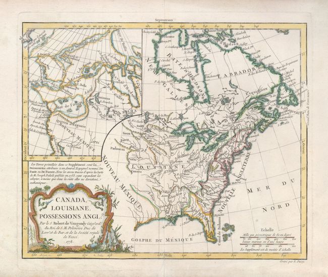
Auction 127, Lot 135
Subject: Colonial United States and Canada
Robert de Vaugondy, Didier
Canada, Louisiane, Possessions Angl?, 1778
Size: 11.4 x 9.5 inches (29 x 24.1 cm)
Estimate: $325 - $400
Unsold
Closed on 2/25/2009
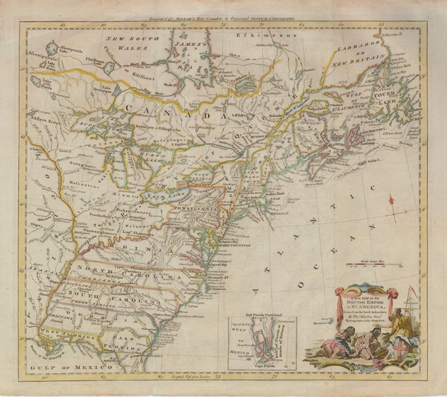
Auction 127, Lot 136
Subject: Colonial United States and Canada
Kitchin, Thomas
A New Map of the British Empire in Nth. America, Drawn from the Latest Authorities, 1782
Size: 15 x 13 inches (38.1 x 33 cm)
Estimate: $700 - $800
Sold for: $600
Closed on 2/25/2009
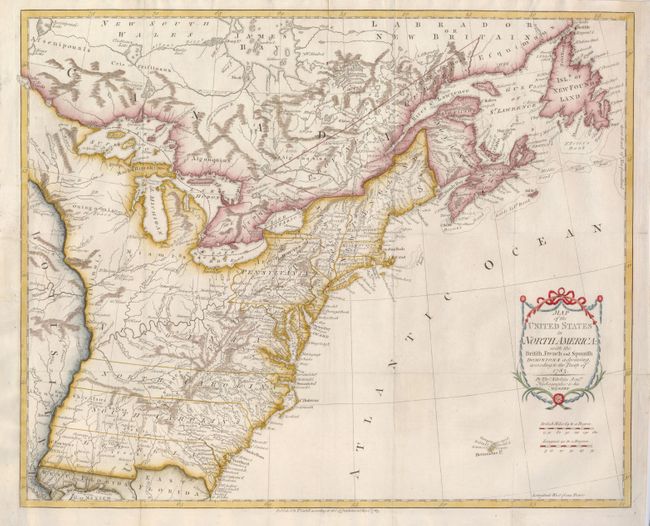
Auction 127, Lot 137
Subject: Eastern United States and Canada
Kitchin, Thomas
Map of the United States in North America: with the British, French and Spanish Dominions adjoining, according to the Treaty of 1783, 1783
Size: 20 x 16 inches (50.8 x 40.6 cm)
Estimate: $1,100 - $1,500
Sold for: $800
Closed on 2/25/2009
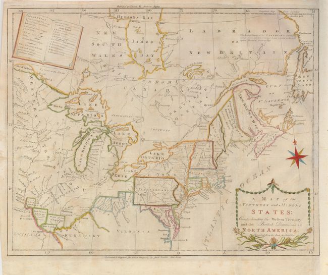
Auction 127, Lot 138
Subject: Eastern United States and Canada
Doolittle, Amos
A Map of the Northern and Middle States: Comprehending the Western Territory and the British Dominions in North America, Compiled from the Best Authorities, 1793
Size: 16 x 12.5 inches (40.6 x 31.8 cm)
Estimate: $450 - $550
Sold for: $475
Closed on 2/25/2009
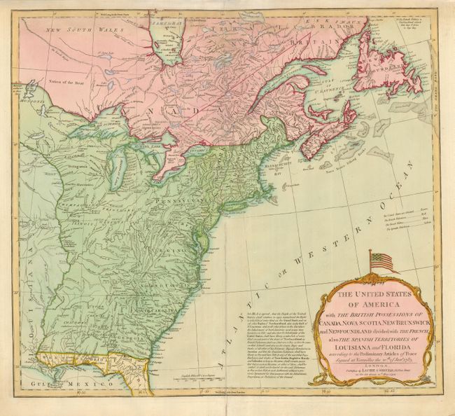
Auction 127, Lot 139
Subject: Eastern United States and Canada
Laurie & Whittle
The United States of America with the British Possessions of Canada, Nova Scotia, New Brunswick and Newfoundland divided with the French, also the Spanish Territories of Louisiana and Florida…, 1794
Size: 20 x 17.8 inches (50.8 x 45.2 cm)
Estimate: $1,200 - $1,400
Unsold
Closed on 2/25/2009
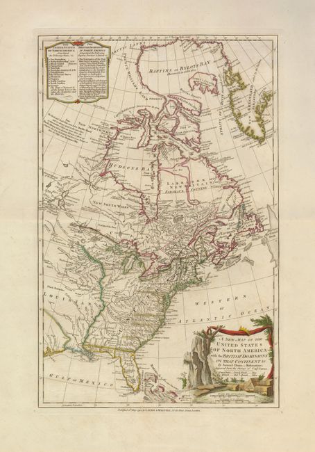
Auction 127, Lot 140
Subject: Eastern United States and Canada
Dunn, Samuel
A New Map of the United States of North America with the British Dominions on that Continent &c., 1794
Size: 12 x 18.6 inches (30.5 x 47.2 cm)
Estimate: $1,100 - $1,300
Unsold
Closed on 2/25/2009
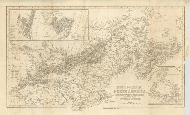
Auction 127, Lot 141
Subject: Eastern Canada & United States
Harper Bros.
British Possessions in North America with Part of the United States Compiled from Official Sources, 1843
Size: 24 x 14 inches (61 x 35.6 cm)
Estimate: $200 - $250
Unsold
Closed on 2/25/2009
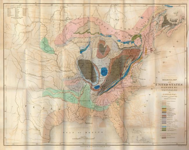
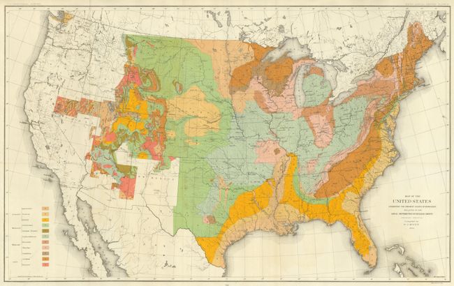
Auction 127, Lot 142
Subject: Eastern United States and Canada, Texas
Lyell, Charles
Geological Map of the United States Canada &c. Compiled from the State Surveys of the U.S. and Other Sources, 1845
Size: 19.5 x 15 inches (49.5 x 38.1 cm)
Estimate: $300 - $350
Sold for: $375
Closed on 2/25/2009
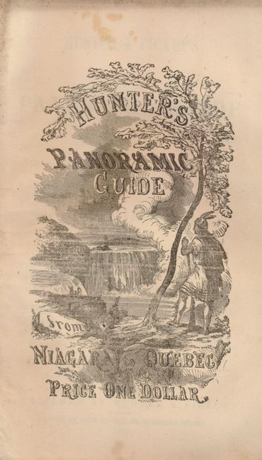
Auction 127, Lot 143
Subject: Canada & New York, Niagara Falls
Hunter, William S.
Hunter & Pickup's Panoramic Guide from Niagara Falls to Quebec, 1866
Size: 6 x 132 inches (15.2 x 335.3 cm)
Estimate: $200 - $250
Unsold
Closed on 2/25/2009
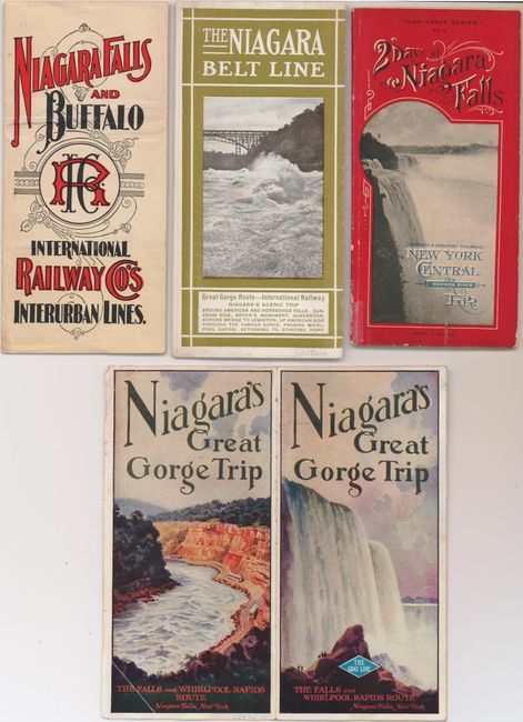
Auction 127, Lot 144
Subject: Canada & New York, Niagara Falls
Railroad Companies, (Various)
[Lot of 4 - Niagara Falls], 1896-1930
Size: 4.3 x 8.5 inches (10.9 x 21.6 cm)
Estimate: $160 - $200
Sold for: $170
Closed on 2/25/2009
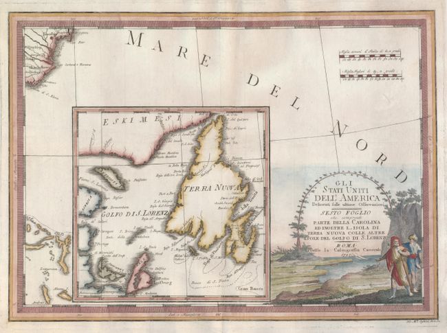
Auction 127, Lot 145
Subject: Canada and United States
Cassini, Giovanni Maria
Gli Stati Uniti dell'America Delineati sulle ultime Osservazioni - Sesto Foglio che comprende Parte Della Carolina Ed Inoltre l'Isola di Terra Nuova Colle Altre Isole del Golfo di S. Lorenzo, 1797
Size: 19 x 13.5 inches (48.3 x 34.3 cm)
Estimate: $475 - $550
Unsold
Closed on 2/25/2009
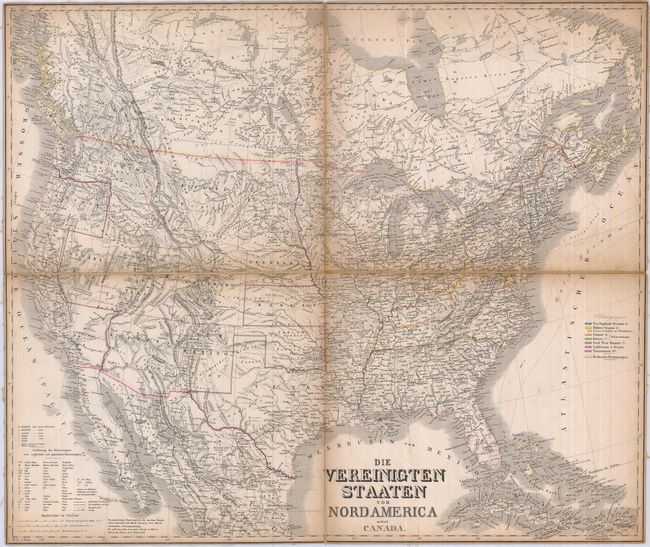
Auction 127, Lot 146
Subject: Canada & United States
Graf, C.
[Lot of 2] Die Vereinigten Staaten von Nordamerica nebst Canada [and] Die Vereinigten Staaten von Nordamerika (Ostlicher Theil), 1860
Size: See Description
Estimate: $200 - $250
Unsold
Closed on 2/25/2009
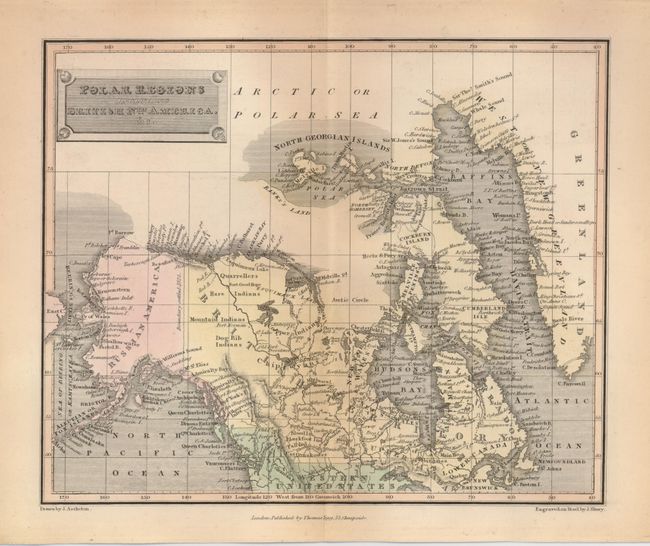
Auction 127, Lot 148
Subject: Canada and Alaska
Tegg, Thomas
Polar Regions including British Nth. America, &c., 1820
Size: 10 x 8.2 inches (25.4 x 20.8 cm)
Estimate: $80 - $100
Sold for: $60
Closed on 2/25/2009
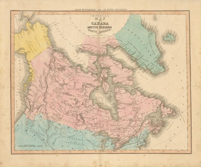
Auction 127, Lot 149
Subject: Arctic, Canada & Alaska
Caldwell, Robert
Imperial Map of Canada and Arctic Regions of North America, 1849
Size: 21.8 x 17.3 inches (55.4 x 43.9 cm)
Estimate: $150 - $190
Unsold
Closed on 2/25/2009
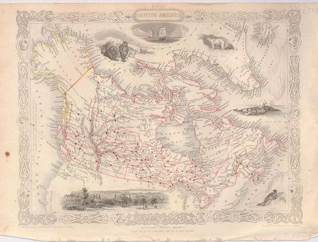
Auction 127, Lot 150
Subject: Canada and Alaska
Tallis, John
British America, 1851
Size: 12.8 x 10.3 inches (32.5 x 26.2 cm)
Estimate: $160 - $200
Sold for: $80
Closed on 2/25/2009
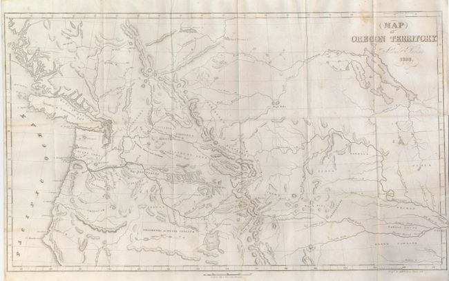
Auction 127, Lot 151
Subject: Northwestern United States and Canada
Parker, Samuel (Rev.)
Journal of an Exploring Tour Beyond the Rocky Mountains … with a Map of Oregon Territory, 1844
Size: 5 x 8 inches (12.7 x 20.3 cm)
Estimate: $500 - $700
Sold for: $550
Closed on 2/25/2009
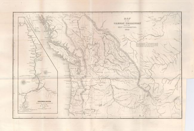
Auction 127, Lot 152
Subject: Northwestern United States and Canada
Wilkes, Charles
Map of the Oregon Territory from the Best Authorities, 1849
Size: 13 x 8 inches (33 x 20.3 cm)
Estimate: $180 - $250
Sold for: $275
Closed on 2/25/2009
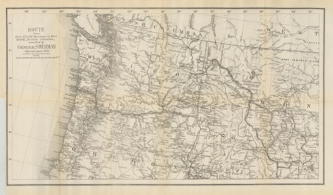
Auction 127, Lot 153
Subject: Canada & Northwestern United States
U.S. Government
Route from Fort Ellis Montana to Fort Hope, British Columbia Traveled by General Sherman July and August 1883…, 1883
Size: 27 x 15 inches (68.6 x 38.1 cm)
Estimate: $150 - $200
Sold for: $190
Closed on 2/25/2009
Auction 127, Lot 154
Subject: United States
[Lot of 17 - United States Views], 1840-1850
Size: 6 x 4 inches (15.2 x 10.2 cm)
Estimate: $250 - $350
Sold for: $150
Closed on 2/25/2009
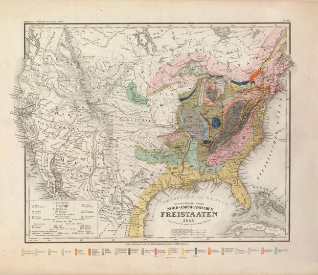
Auction 127, Lot 155
Subject: United States
Hildburghausen Biblio Institut
Geognostische Karte der Nord-Americanischen Freistaaten, 1852
Size: 14 x 11.5 inches (35.6 x 29.2 cm)
Estimate: $150 - $200
Sold for: $230
Closed on 2/25/2009
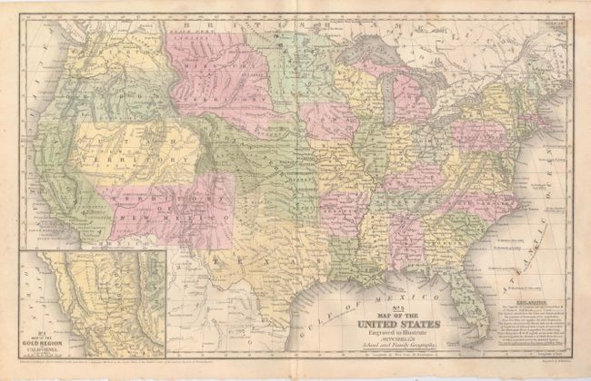
Auction 127, Lot 156
Subject: United States
Mitchell, Samuel Augustus
No. 5 Map of the United States Engraved to Illustrate Mitchell's School and Family Geography, 1852
Size: 16.7 x 10.5 inches (42.4 x 26.7 cm)
Estimate: $250 - $350
Unsold
Closed on 2/25/2009
Auction 127, Lot 157
Subject: United States
Colton, Joseph Hutchins
The United States of America, 1855
Size: 26.5 x 17.5 inches (67.3 x 44.5 cm)
Estimate: $400 - $600
Unsold
Closed on 2/25/2009

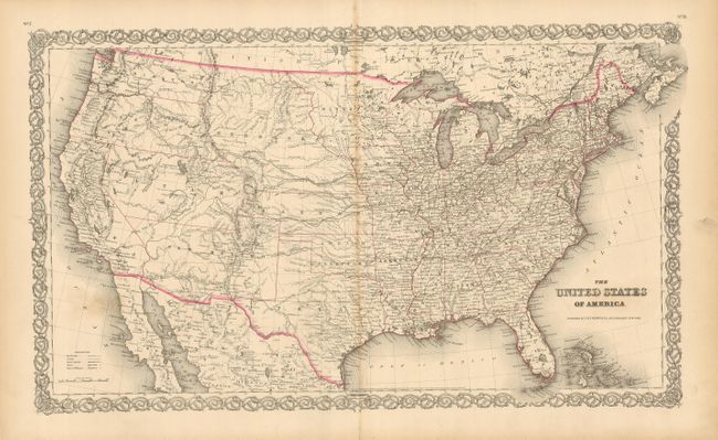
Auction 127, Lot 158
Subject: United States
Johnson & Browning
Colton's United States of America, 1859
Size: 26.5 x 15.5 inches (67.3 x 39.4 cm)
Estimate: $750 - $900
Sold for: $550
Closed on 2/25/2009
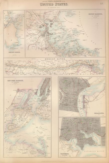
Auction 127, Lot 159
Subject: Eastern United States
Fullarton, Archibald & Co.
[Lot of 2] Northern Ports & Harbours in the United States [and] Southern Ports & Harbours in the United States, 1860
Size: 11.8 x 17 inches (30 x 43.2 cm)
Estimate: $140 - $180
Unsold
Closed on 2/25/2009
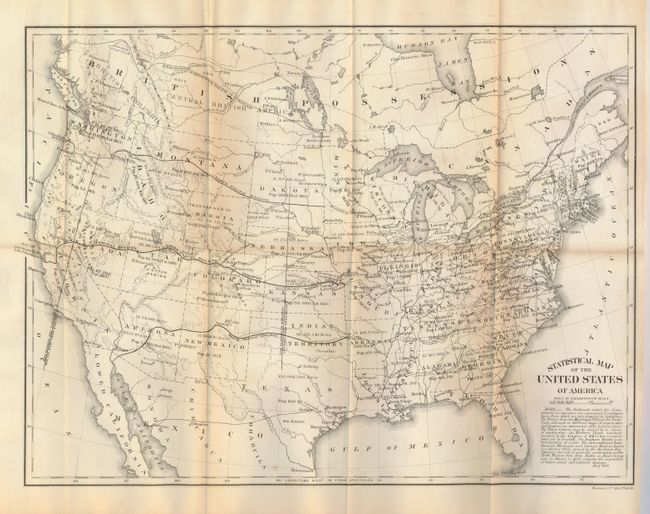
Auction 127, Lot 160
Subject: United States
U.S. Government
Statistical Map of the United States of America, 1864
Size: 19.8 x 14.8 inches (50.3 x 37.6 cm)
Estimate: $100 - $140
Unsold
Closed on 2/25/2009
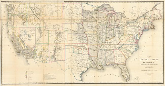
Auction 127, Lot 161
Subject: United States
General Land Office
Map of the United States and Territories Showing the extent of Public Surveys and other details constructed from the Plats and official sources of the General Land Office…, 1866
Size: 54.5 x 28 inches (138.4 x 71.1 cm)
Estimate: $350 - $450
Sold for: $250
Closed on 2/25/2009
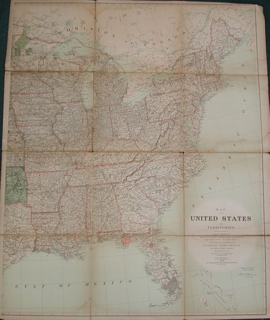
Auction 127, Lot 162
Subject: United States
General Land Office
Map of the United States and Territories Showing the Extent of Public Surveys, Indian and Military Reservations, Land Grant R.R; Rail Roads, Canals…, 1882
Size: 39 x 49 inches (99.1 x 124.5 cm)
Estimate: $150 - $200
Unsold
Closed on 2/25/2009
Auction 127, Lot 163
Subject: United States
U.S. Geological Survey (USGS)
Map of the United States Exhibiting the Present Status of Knowledge Relating to the Areal Distribution of Geologic Groups, 1884
Size: 28 x 17.3 inches (71.1 x 43.9 cm)
Estimate: $160 - $220
Sold for: $250
Closed on 2/25/2009
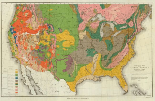
Auction 127, Lot 164
Subject: United States
Hitchcock, Charles Henry
Geological Map of the United States and Part of Canada Compiled by C.H. Hitchcock for the American Institute of Mining Engineers to Illustrate the Schemes of Coloration and Nomenclature Recommended by the International Geological Congress, 1886
Size: 27.8 x 17.3 inches (70.6 x 43.9 cm)
Estimate: $200 - $300
Sold for: $650
Closed on 2/25/2009
Auction 127, Lot 165
Subject: United States
Matthews-Northrup Co
Map of the United States, 1891
Size: 20.3 x 11.4 inches (51.6 x 29 cm)
Estimate: $80 - $120
Unsold
Closed on 2/25/2009
Auction 127, Lot 166
Subject: United States
[Lot of 5 - Indian Reservations], 1892-1919
Size: See Description
Estimate: $200 - $300
Sold for: $160
Closed on 2/25/2009
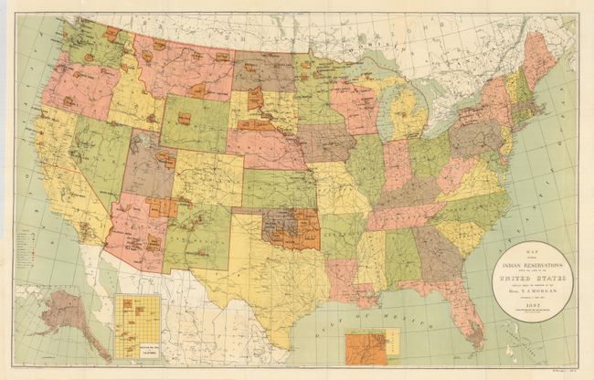
Auction 127, Lot 167
Subject: United States
U.S. Government
Map Showing Indian Reservations within the Limits of the United States Compiled under the Direction of the Hon. T.J. Morgan, 1894
Size: 33 x 21 inches (83.8 x 53.3 cm)
Estimate: $90 - $130
Sold for: $65
Closed on 2/25/2009
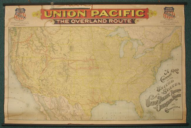
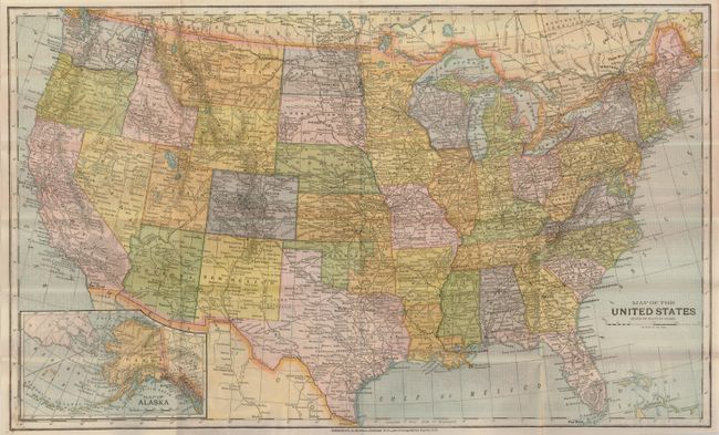
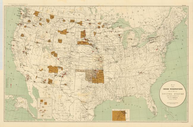
Auction 127, Lot 168
Subject: United States
Rand McNally & Co.
A Correct Map of the United States Showing the Union Pacific Railroad. The Overland Route and Connections, 1896
Size: 53.5 x 35 inches (135.9 x 88.9 cm)
Estimate: $500 - $700
Sold for: $300
Closed on 2/25/2009
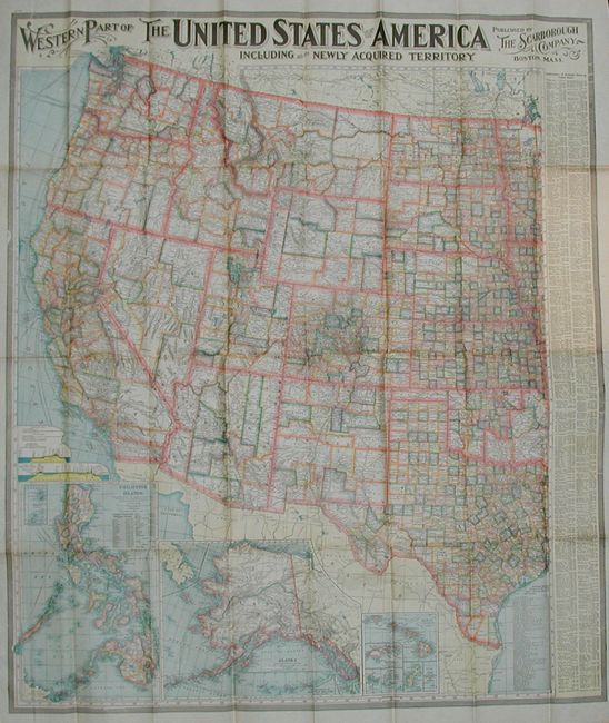
Auction 127, Lot 169
Subject: United States
Scarborough Company, The
Eastern Part of the United States of America Including All Its Newly Acquired Territories [and] Western Part…, 1903
Size: 36 x 33.5 inches (91.4 x 85.1 cm)
Estimate: $120 - $180
Sold for: $75
Closed on 2/25/2009
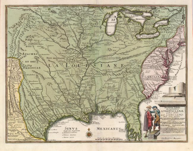
Auction 127, Lot 170
Subject: Colonial United States
Weigel, Christopher
Novissima Tabula Regionis Ludovicianae Gallice dicta la Louisiane…, 1734
Size: 16.3 x 12.5 inches (41.4 x 31.8 cm)
Estimate: $1,500 - $1,800
Sold for: $950
Closed on 2/25/2009
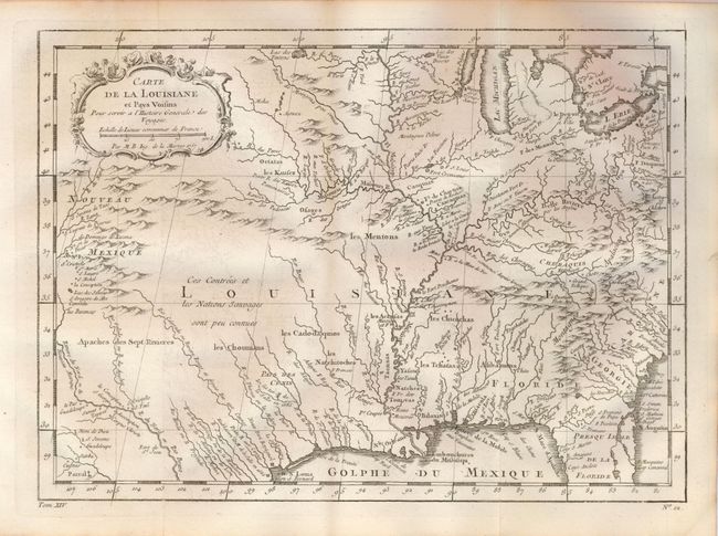
Auction 127, Lot 171
Subject: Colonial Central United States
Bellin, Jacques Nicolas
Carte de la Louisiane et Pays Voisins Pour servir a l'Histoire Generale des Voyages, 1757
Size: 12 x 8.8 inches (30.5 x 22.4 cm)
Estimate: $200 - $300
Sold for: $350
Closed on 2/25/2009
Auction 127, Lot 172
Subject: Eastern United States
Stockdale, John
Part of the United States of North America, 1798
Size: 18.5 x 16.2 inches (47 x 41.1 cm)
Estimate: $250 - $300
Sold for: $190
Closed on 2/25/2009
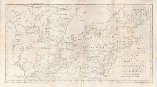
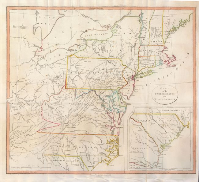
Auction 127, Lot 173
Subject: Eastern United States
Bradley, Abraham Jr.
Map of the Northern Parts of the United States of America by Abraham Bradley Jr. Corrected by the Author, 1802
Size: 15 x 8 inches (38.1 x 20.3 cm)
Estimate: $200 - $300
Sold for: $150
Closed on 2/25/2009
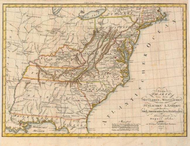
Auction 127, Lot 174
Subject: Eastern United States
Dupuis, John
Neue Charte von den Mittleren, Westlichen und Sudlichen Landern der Nord-Americanischen Freistaaten, 1805
Size: 18.5 x 13.3 inches (47 x 33.8 cm)
Estimate: $500 - $600
Unsold
Closed on 2/25/2009
Auction 127, Lot 175
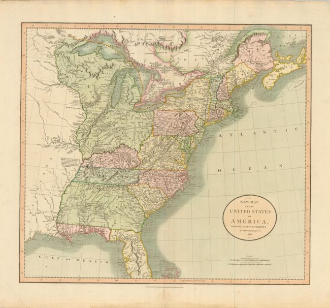
Subject: Eastern United States
Cary, John
A New Map of the United States of America, from the Latest Authorities, 1806
Size: 20 x 17.8 inches (50.8 x 45.2 cm)
Estimate: $750 - $900
Unsold
Closed on 2/25/2009
238 lots
Page 1 of 5