Subject: Eastern United States and Canada
Period: 1793 (circa)
Publication: Morse's American Universal Geography
Color: Hand Color
Size:
16 x 12.5 inches
40.6 x 31.8 cm
By the time of the Revolutionary War, the practice of awarding bounty land as an inducement for enlisting in the military had been a long-standing practice in colonial North America. Besides imperial bounty land grants, both colonial and municipal governments routinely compensated participants in and victims of military conflicts with land. Land was a commodity in generous supply, and governments seized upon its availability for accomplishing their goals.
Following this tradition, the Revolutionary governments used bounty land grants in their struggle for independence from Great Britain. They generally offered free lands in exchange for military service, provided they were victorious in their struggle. Thus, bounty lands were an effective technique for enrolling support for the war and encouraging re-enlistments. Generally the bounty lands were located on the western frontier, which provided another benefit to the government. Populating the frontier with citizens skilled in defense offered the best prospect in enticing other settlers to join them, thus eventually increasing the tax rolls.
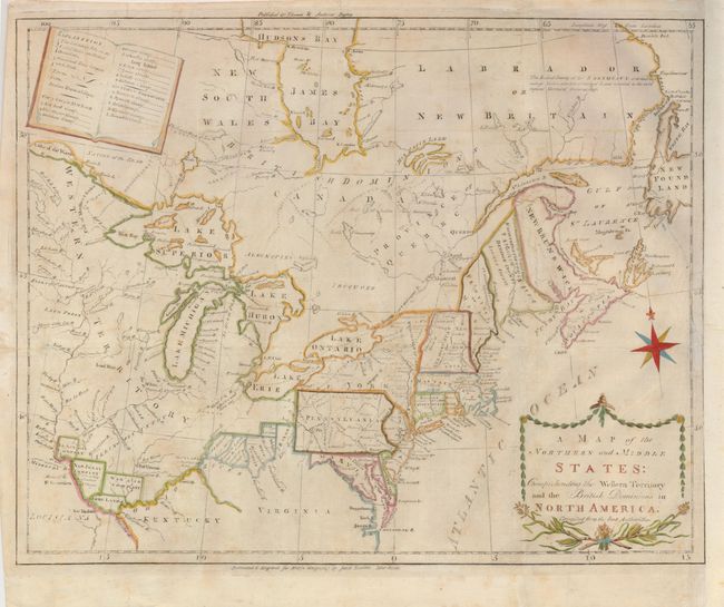
This uncommon and information-packed map describes the region from James Bay to Chesapeake Bay and the confluence of the Mississippi and Ohio Rivers, and from the Lake of the Woods to the Gulf of St. Lawrence. An explanation of the various symbols used in the map are displayed in the form of an open book in the upper left corner. Several of the districts and states are shown with distorted borders, but the most interesting feature of the map are the numerous Bounty Land Grants shown in the western frontier.
References: McCorkle #789.6; Kershaw #386; Sellers & Van Ee #194; Wheat & Brun #153.
Condition: B
Issued folding, now flattened. Uneven impression with some light toning and foxing. The map has been trimmed to the neatline (with a tiny bit of loss) and remargined at right. A 2" binding tear has been repaired with tissue on verso.