Showing Featured Lots(remove filter)
Filtered by Category:United States(Show All Categories)
Showing results for:Auction 117
Catalog Archive
17 lots
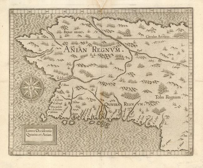
Auction 117, Lot 94
Subject: Western Canada & Alaska
Wytfliet, Cornelis
Limes Occidentis Quivira et Anian, 1607
Size: 11.5 x 9.2 inches (29.2 x 23.4 cm)
Estimate: $1,900 - $2,100
Unsold
Closed on 12/6/2006
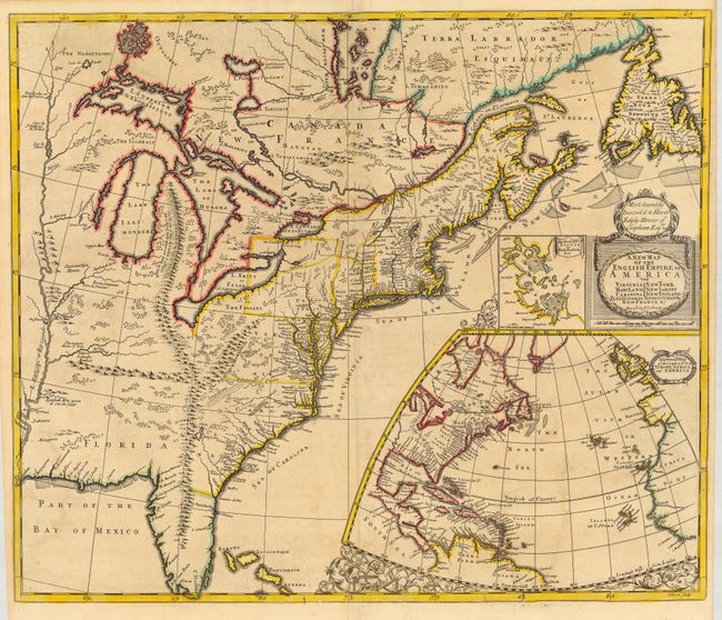
Auction 117, Lot 114
Subject: Colonial United States and Canada
Morden/Senex
A New Map of the English Empire in America viz Virginia, Maryland, Carolina, New York, New Iarsey, New England…, 1719
Size: 23.3 x 19.8 inches (59.2 x 50.3 cm)
Estimate: $2,000 - $2,500
Sold for: $2,500
Closed on 12/6/2006
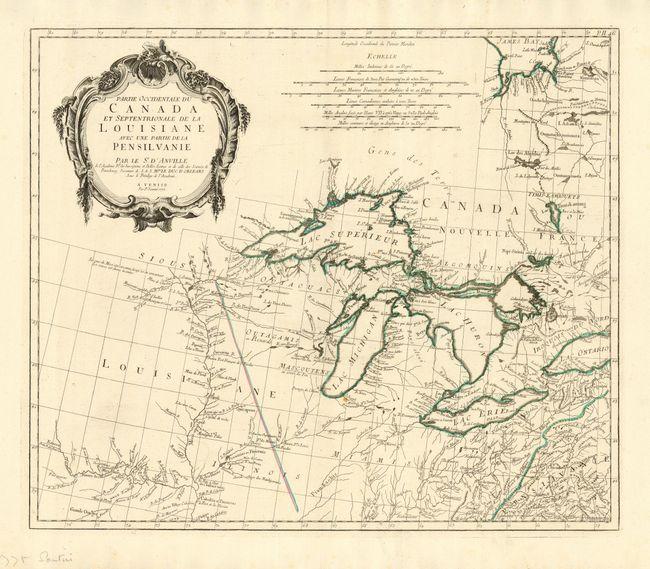
Auction 117, Lot 126
Subject: Colonial Great Lakes
D'Anville/Santini
Partie Occidentale du Canada et Septentrionale de la Louisiane avec une partie de la Pensilvanie, 1775
Size: 22.3 x 18.9 inches (56.6 x 48 cm)
Estimate: $1,100 - $1,300
Sold for: $750
Closed on 12/6/2006
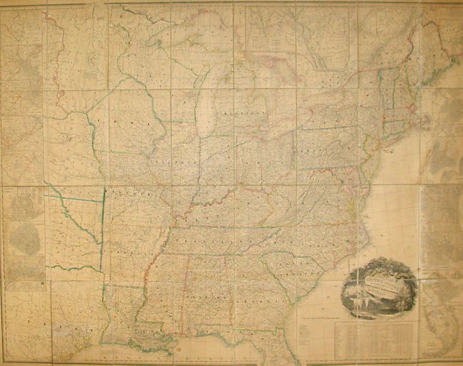
Auction 117, Lot 138
Subject: United States
Tanner, Henry Schenck
A Map of the United States Including Every County Enumerated in the Last Census & Since Formed with Population, of the several States, Railroads Canals &c., 1845
Size: 61 x 46 inches (154.9 x 116.8 cm)
Estimate: $14,000 - $18,000
Unsold
Closed on 12/6/2006
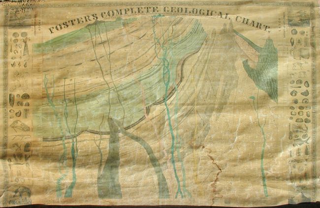
Auction 117, Lot 141
Subject: United States
Foster, J.T.
Foster's Complete Geological Chart. Exhibiting in their Successive Order of Deposition, the Various Rocks, Which Form the Crust of our Globe, Arranged According to the Best Authorities in Europe & America, 1849
Size: 67.5 x 47.5 inches (171.5 x 120.7 cm)
Estimate: $300 - $500
Sold for: $210
Closed on 12/6/2006
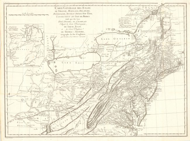
Auction 117, Lot 148
Subject: Eastern United States
Crevecoeur, Michel Guillaume De
Carte Generale des Etats de Virginie, Maryland, Delaware, Pensilvanie, Nouveau-Jersey, New-York, Connecticut et Isle de Rhodes Ainsi que des Lacs Erie, Ontario, et Champlain…, 1787
Size: 25.6 x 18.8 inches (65 x 47.8 cm)
Estimate: $1,500 - $1,800
Unsold
Closed on 12/6/2006
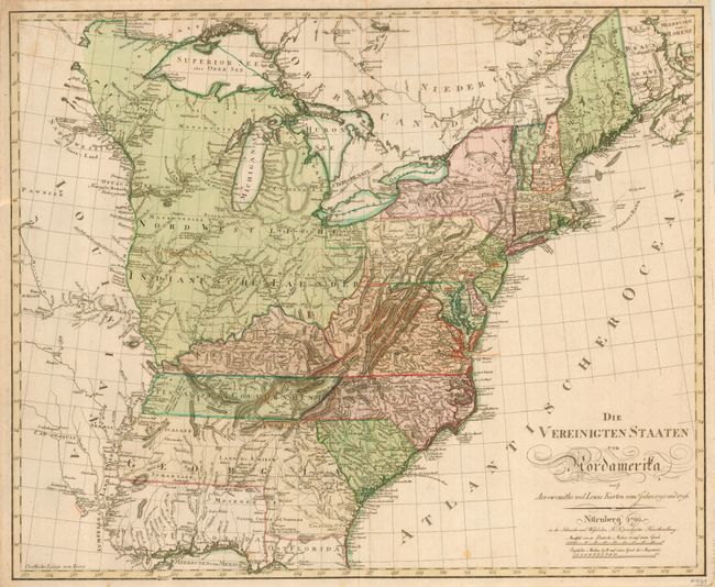
Auction 117, Lot 149
Subject: Eastern United States
Schneider and Weigel
Die Vereinigten Staaten von Nordamerika…, 1799
Size: 25.5 x 21 inches (64.8 x 53.3 cm)
Estimate: $3,000 - $3,250
Sold for: $2,400
Closed on 12/6/2006

Auction 117, Lot 152
Subject: Eastern United States
Norie, John William
Chart of North America from Boston to the Strait of Florida and Havana, 1896
Size: 105.5 x 33.75 inches (268 x 85.7 cm)
Estimate: $1,200 - $2,500
Sold for: $1,800
Closed on 12/6/2006
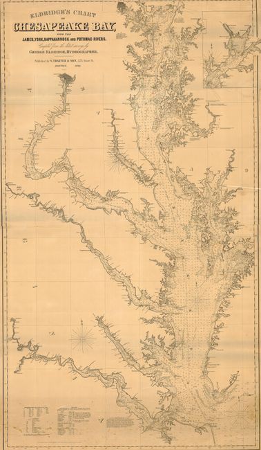
Auction 117, Lot 160
Subject: United States - Mid-Atlantic
Eldridge, George
Eldridge's Chart of Chesapeake Bay with the James, York, Rappahannock and Potomac Rivers, 1898
Size: 32.5 x 56.5 inches (82.6 x 143.5 cm)
Estimate: $1,500 - $2,000
Sold for: $950
Closed on 12/6/2006
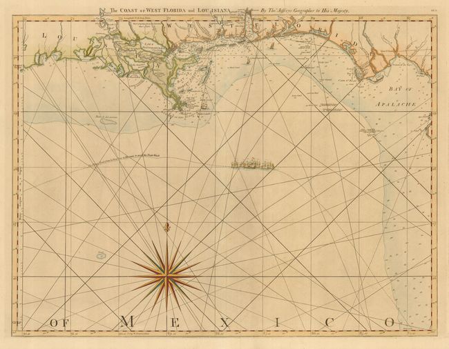
Auction 117, Lot 165
Subject: Colonial Southern United States
Jefferys, Thomas
The Coast of West Florida and Louisiana, 1775
Size: 24.5 x 18.8 inches (62.2 x 47.8 cm)
Estimate: $1,600 - $1,800
Sold for: $1,700
Closed on 12/6/2006
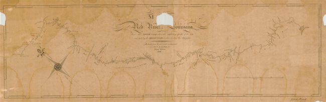
Auction 117, Lot 170
Subject: Southern United States
King, Nicholas
Map of the Red River in Louisiana from the Spanish Camp Where the Exploring Party of the U.S. was met by the Spanish Troops to where it enters the Mississippi, 1806
Size: 27.8 x 8.1 inches (70.6 x 20.6 cm)
Estimate: $15,000 - $25,000
Sold for: $31,000
Closed on 12/6/2006
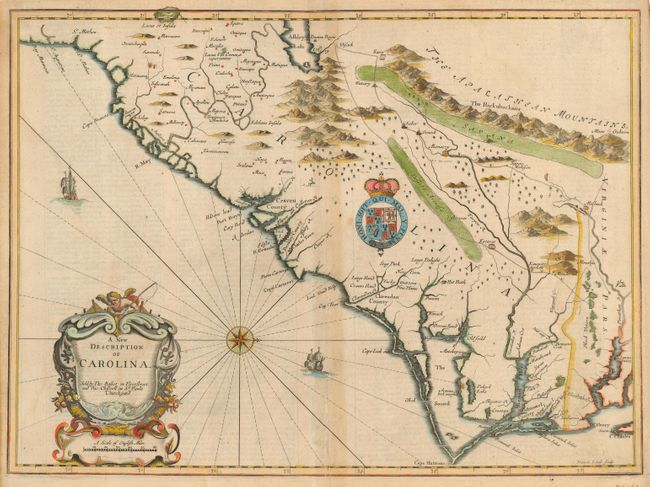
Auction 117, Lot 174
Subject: Colonial Southeast United States
Speed/Lamb
A New Description of Carolina, 1676
Size: 20 x 14.6 inches (50.8 x 37.1 cm)
Estimate: $3,500 - $5,000
Sold for: $2,500
Closed on 12/6/2006
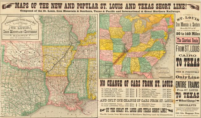
Auction 117, Lot 190
Subject: United States - Texas and Midwest
Railroad Companies, (Various)
Maps of the New and Popular St. Louis and Texas Short Line! Composed of the St. Louis, Iron Mountain & Southern, Texas & Pacific and International & Great Northern Railways, 1878
Size: 31 x 18 inches (78.7 x 45.7 cm)
Estimate: $500 - $700
Sold for: $600
Closed on 12/6/2006
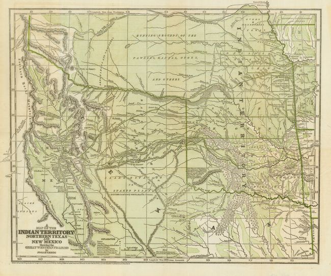
Auction 117, Lot 204
Subject: South-Central United States, Indian Territory
Gregg, Josiah
A Map of the Indian Territory Northern Texas and New Mexico Showing the Great Western Prairies, 1844
Size: 14.9 x 12.3 inches (37.8 x 31.2 cm)
Estimate: $500 - $700
Sold for: $1,000
Closed on 12/6/2006
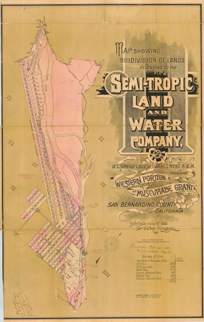
Auction 117, Lot 228
Subject: California - Rialto
[Lot of 2] Map Showing Subdivision of Lands Belonging to the Semi-Tropic Land and Water Company [together with] Map of the Town of Rialto, 1887
Size: See Description
Estimate: $350 - $500
Sold for: $400
Closed on 12/6/2006
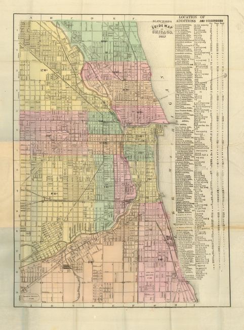
Auction 117, Lot 254
Subject: Illinois, Chicago
Blanchard & Cram
Blanchard's Guide Map of Chicago, 1867
Size: 13 x 18.3 inches (33 x 46.5 cm)
Estimate: $800 - $1,200
Sold for: $400
Closed on 12/6/2006
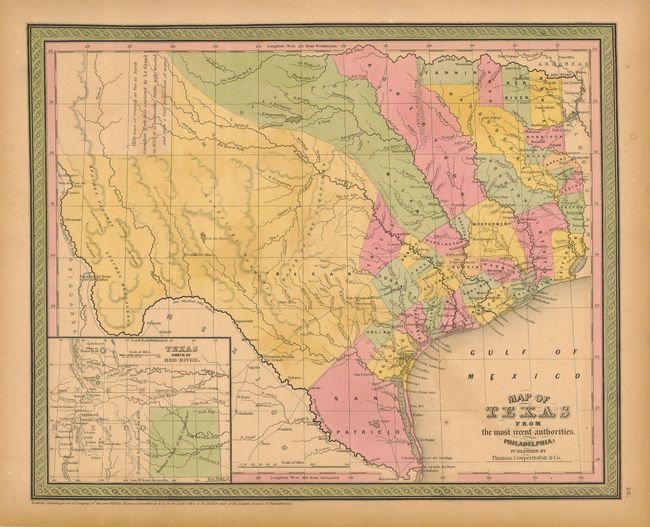
Auction 117, Lot 326
Subject: Texas
Thomas, Cowperthwait & Co.
Map of Texas from the most recent authorities, 1850
Size: 15 x 12 inches (38.1 x 30.5 cm)
Estimate: $800 - $1,200
Sold for: $750
Closed on 12/6/2006
17 lots