Filtered by Category:Canada(Show All Categories)
Showing results for:Auction 183
Catalog Archive
19 lots
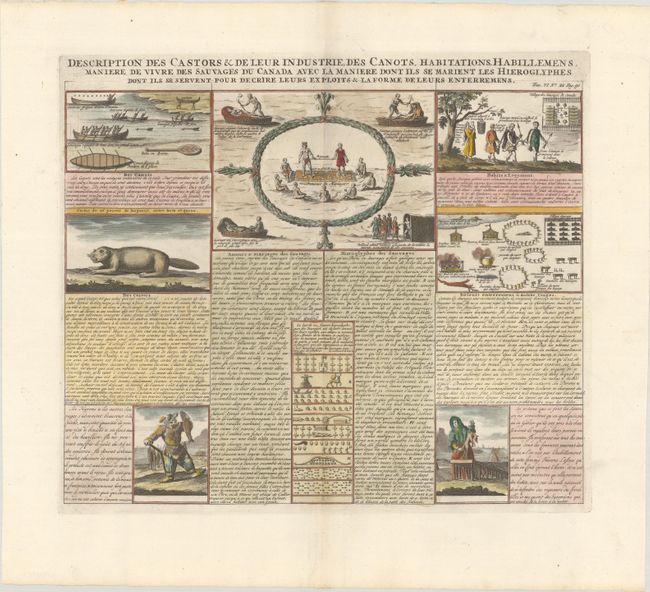
Auction 183, Lot 77
Subject: Canada
Chatelain, Henry Abraham
Description des Castors & de Leur Industrie, des Canots, Habitations, Habillemens Maniere de Vivre des Sauvages du Canada avec la Maniere dont ils se Marient les Hieroglyphes..., 1708
Size: 16.8 x 14.4 inches (42.7 x 36.6 cm)
Estimate: $240 - $300
Sold for: $190
Closed on 6/9/2021
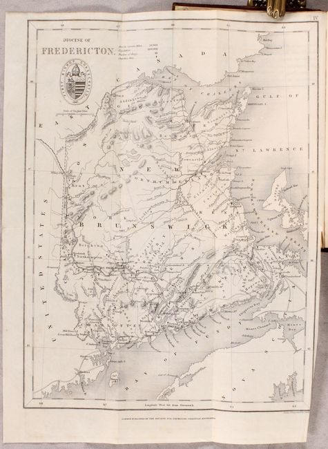
Auction 183, Lot 78
Subject: Eastern Canada
Society for Promoting Christian Knowledge (SPCK)
[Map in Book] Diocese of Fredericton [in] Annals of the Diocese of Fredericton, 1847
Size: 8.1 x 10.8 inches (20.6 x 27.4 cm)
Estimate: $200 - $250
Sold for: $100
Closed on 6/9/2021
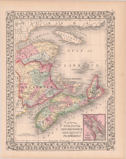
Auction 183, Lot 79
Subject: Eastern Canada
Mitchell, Samuel Augustus
County Map of Nova Scotia New Brunswick Cape Breton Id. and Pr. Edward's Id., 1867
Size: 10.7 x 13.6 inches (27.2 x 34.5 cm)
Estimate: $40 - $60
NO RESERVE
Sold for: $170
Closed on 6/9/2021
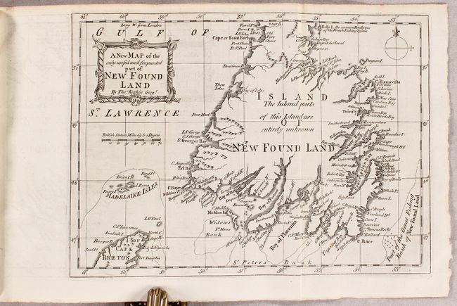
Auction 183, Lot 80
Subject: Newfoundland, Canada
Kitchin, Thomas
A New Map of the Only Useful and Frequented Part of New Found Land [and] The Lyon Entranced [bound in] The Gentleman's and London Magazine. For October, 1762, 1762
Size: 9.6 x 6.9 inches (24.4 x 17.5 cm)
Estimate: $250 - $325
Unsold
Closed on 6/9/2021
Auction 183, Lot 81
Subject: Quebec, Canada
Popple, Henry
[A Map of the British Empire in America (Sheet 2) - Lower Quebec], 1733
Size: 26.8 x 19.2 inches (68.1 x 48.8 cm)
Estimate: $1,000 - $1,300
Popple's Epic Map - Lower Quebec Sheet
Sold for: $750
Closed on 6/9/2021
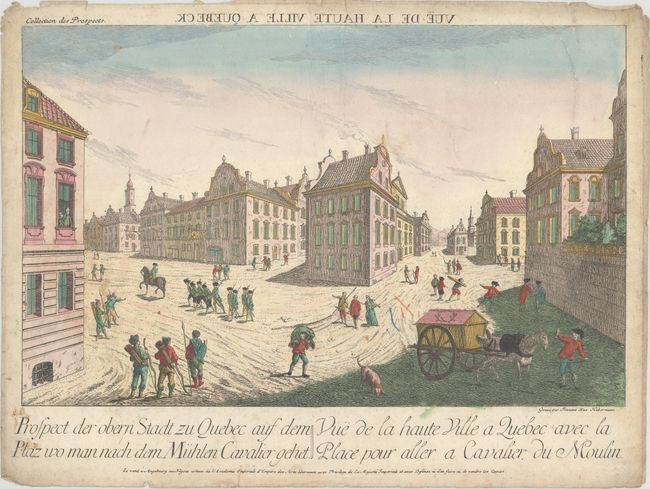
Auction 183, Lot 82
Subject: Quebec City, Canada
Haberman, F. X.
Prospect der Obern Stadt zu Quebec auf dem Plaz wo man nach dem Muhlen Cavalier Gehet / Vue de la Haute Ville a Quebec avec la Place pour Aller a Cavalier du Moulin, 1760
Size: 15.8 x 9.9 inches (40.1 x 25.1 cm)
Estimate: $140 - $170
Sold for: $80
Closed on 6/9/2021
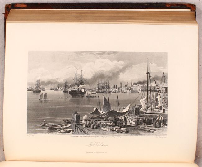
Auction 183, Lot 83
Subject: United States & Canada
Bryant, William C.
[2 Volumes] Picturesque America; or, the Land We Live In..., 1872-74
Size: 10.3 x 13 inches (26.2 x 33 cm)
Estimate: $400 - $475
Sold for: $500
Closed on 6/9/2021
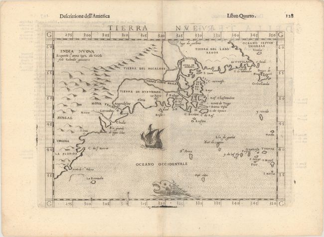
Auction 183, Lot 84
Subject: Eastern United States & Canada
Ruscelli, Girolamo
Tierra Nueva, 1598
Size: 9.6 x 7 inches (24.4 x 17.8 cm)
Estimate: $1,100 - $1,400
Ruscelli's Map of the East Coast
Sold for: $850
Closed on 6/9/2021
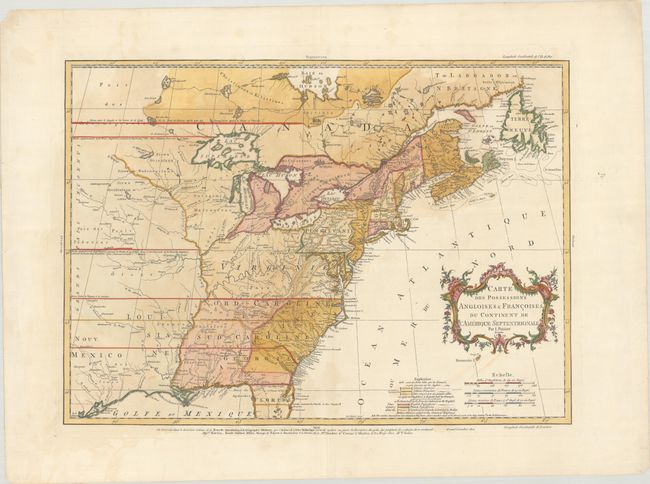
Auction 183, Lot 86
Subject: Colonial Eastern United States & Canada
Palairet, Jean
Carte des Possessions Angloises & Francoises du Continent de l'Amerique Septentrionale, 1756
Size: 22.8 x 16.3 inches (57.9 x 41.4 cm)
Estimate: $2,200 - $2,500
Important Map of French and English Territorial Claims at the Outset of the French & Indian War
Sold for: $2,000
Closed on 6/9/2021
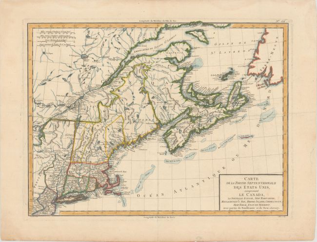
Auction 183, Lot 89
Subject: Northeastern United States & Canada
Tardieu, Pierre Francois
Carte de la Partie Septentrionale des Etats Unis, Comprenant le Canada, la Nouvelle Ecosse, New Hampshire, Massachuset's Bay, Rhode-Island, Connecticut, New-Yorck, Etat de Vermont avec Partie de Pensilvanie et de New-Jersey, 1797
Size: 16.8 x 12.6 inches (42.7 x 32 cm)
Estimate: $180 - $220
Sold for: $325
Closed on 6/9/2021
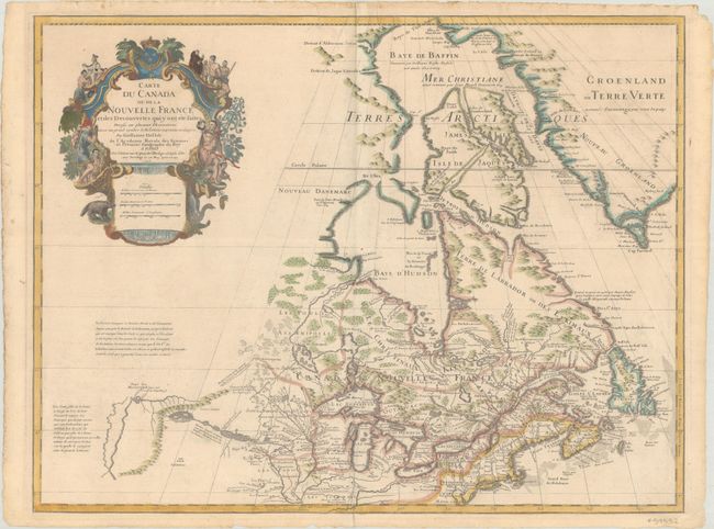
Auction 183, Lot 96
Subject: Colonial Northeastern United States & Canada, Great Lakes
Delisle, Guillaume
Carte du Canada ou de la Nouvelle France et des Decouvertes qui y ont ete Faites Dressee sur Plusieurs Observations et sur un Grand Nombre de Relations Imprimees ou Manuscrites..., 1703
Size: 25.6 x 19.6 inches (65 x 49.8 cm)
Estimate: $1,600 - $1,900
Delisle's Seminal Map of Canada and the Great Lakes
Sold for: $1,400
Closed on 6/9/2021
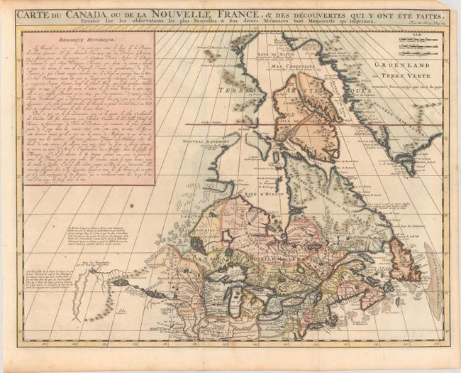
Auction 183, Lot 97
Subject: Colonial Northeastern United States & Canada
Chatelain, Henry Abraham
Carte du Canada ou de la Nouvelle France, & des Decouvertes qui y ont ete Faites, Dressee sur les Observations les Plus Nouvelles, & sur Divers Memoires tant Manuscrits qu' Imprimez, 1719
Size: 20.5 x 16.1 inches (52.1 x 40.9 cm)
Estimate: $550 - $700
Sold for: $400
Closed on 6/9/2021
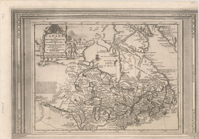
Auction 183, Lot 98
Subject: Colonial Northeastern United States & Canada
Aa, Pieter van der
Canada ou Nouvelle France, Suivant les Nouvelles Observations de Messrs. de l'Academie Royale des Sciences, Etc., 1730
Size: 14.9 x 10.4 inches (37.8 x 26.4 cm)
Estimate: $450 - $550
Unusual Picture-Frame Style Border
Sold for: $300
Closed on 6/9/2021
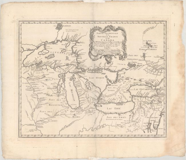
Auction 183, Lot 99
Subject: Colonial Great Lakes
Bellin/Homann Heirs
Partie Occidentale de la Nouvelle France ou du Canada, 1755
Size: 21.4 x 16.8 inches (54.4 x 42.7 cm)
Estimate: $1,400 - $1,700
Influential Map of the Great Lakes
Sold for: $1,200
Closed on 6/9/2021
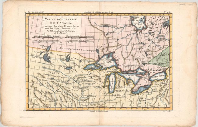
Auction 183, Lot 100
Subject: Colonial Great Lakes
Bonne, Rigobert
Partie Occidentale du Canada, Contenant les Cinq Grands Lacs, avec les Pays Circonvoisins, 1775
Size: 12.6 x 8.3 inches (32 x 21.1 cm)
Estimate: $200 - $230
Sold for: $150
Closed on 6/9/2021
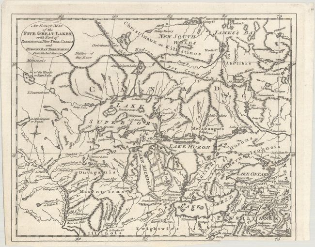
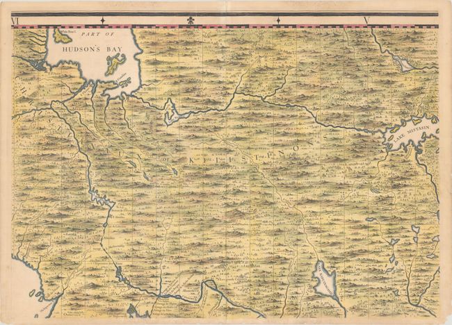
Auction 183, Lot 101
Subject: Colonial Great Lakes, Canada
Lodge, John
An Exact Map of the Five Great Lakes, with Part of Pensilvania, New York, Canada and Hudsons Bay Territories. From the Best Surveys, 1778
Size: 10.1 x 8.1 inches (25.7 x 20.6 cm)
Estimate: $300 - $375
Sold for: $220
Closed on 6/9/2021
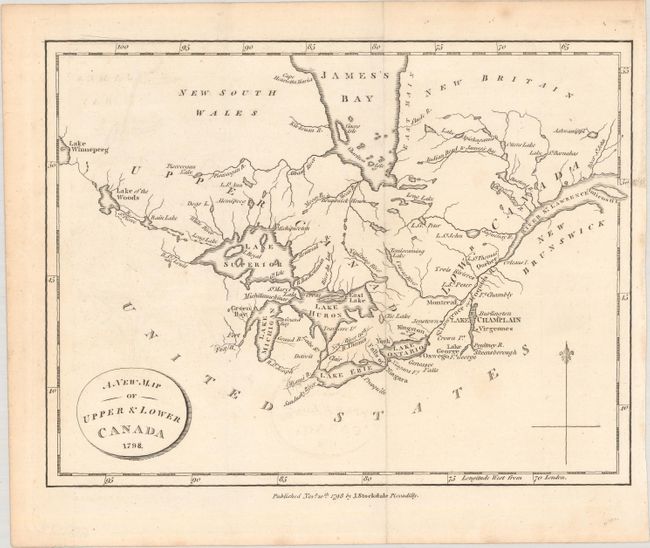
Auction 183, Lot 102
Subject: Great Lakes, Canada
Weld, Isaac
A New Map of Upper & Lower Canada, 1798
Size: 8.9 x 6.8 inches (22.6 x 17.3 cm)
Estimate: $120 - $150
Sold for: $60
Closed on 6/9/2021
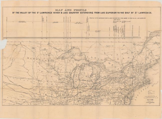
Auction 183, Lot 103
Subject: Great Lakes, St. Lawrence River
Disturnell, John
[Map with Book] Map and Profile of the Valley of the St. Lawrence River & Lake Country Extending from Lake Superior to the Gulf of St. Lawrence [with] A Trip Through the Lakes of North America..., 1857
Size: 30.4 x 19.1 inches (77.2 x 48.5 cm)
Estimate: $160 - $190
Sold for: $120
Closed on 6/9/2021
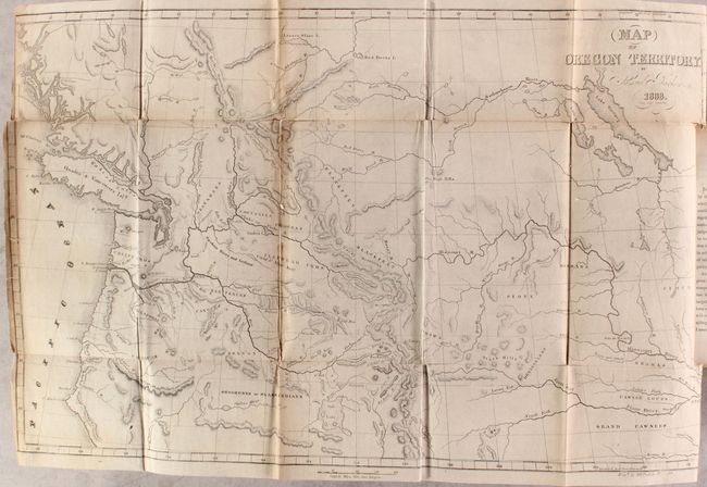
Auction 183, Lot 104
Subject: Western United States & Canada
Parker, Samuel (Rev.)
[Map in Book] Map of Oregon Territory [in] Journal of an Exploring Tour Beyond the Rocky Mountains... , 1842
Size: 22 x 14 inches (55.9 x 35.6 cm)
Estimate: $550 - $700
Sold for: $400
Closed on 6/9/2021
19 lots