Filtered by Category:North America(Show All Categories)
Showing results for:Auction 183
Catalog Archive
19 lots
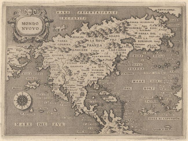
Auction 183, Lot 58
Subject: North America
Porcacchi, Tomaso
Mondo Nuovo, 1576
Size: 5.6 x 4.1 inches (14.2 x 10.4 cm)
Estimate: $800 - $950
Sold for: $850
Closed on 6/9/2021
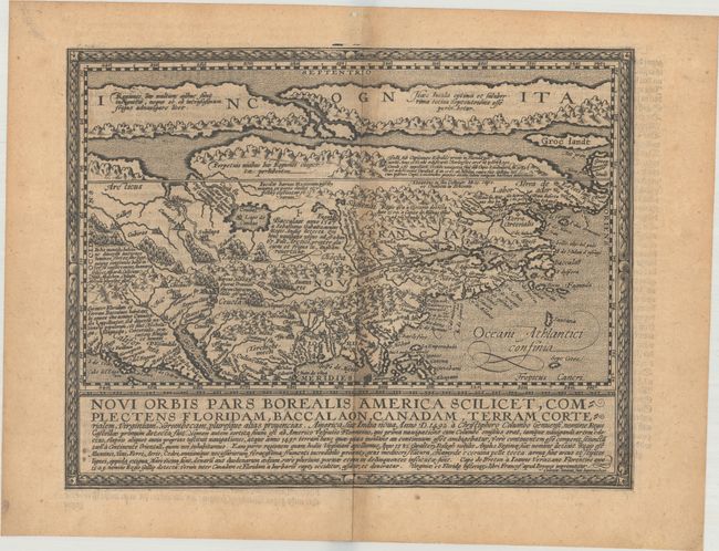
Auction 183, Lot 59
Subject: Colonial North America
Quad, Matthias von Kinckelbach
Novi Orbis Pars Borealis, America Scilicet, Complectens Floridam, Baccalaon, Canadam, Terram Corterialem, Virginiam..., 1600
Size: 11.5 x 8.9 inches (29.2 x 22.6 cm)
Estimate: $2,750 - $3,500
One of the Earliest Maps Devoted to North America
Sold for: $1,800
Closed on 6/9/2021
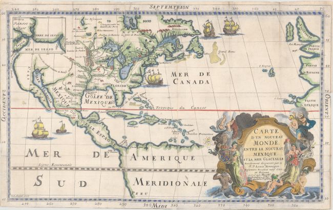
Auction 183, Lot 60
Subject: Colonial North America
Hennepin, Louis de (Fr.)
Carte d'un Nouveau Monde, Entre le Nouveau Mexique, et la Mer Glacialle, 1698
Size: 18.4 x 11.5 inches (46.7 x 29.2 cm)
Estimate: $2,500 - $3,250
Hennepin's Important, Updated Map of North America
Sold for: $3,250
Closed on 6/9/2021
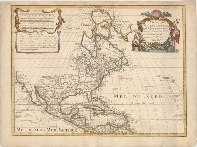
Auction 183, Lot 61
Subject: Colonial North America
Delisle, Guillaume
L'Amerique Septentrionale. Dressee sur les Observations de Mrs. de l'Academie Royale des Sciences. & Quelques Autres, & sur les Memoires les Plus Recens, 1700
Size: 23.8 x 17.9 inches (60.5 x 45.5 cm)
Estimate: $1,600 - $1,900
Delisle's Foundation Map of North America
Sold for: $1,100
Closed on 6/9/2021
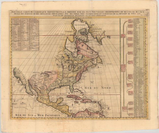
Auction 183, Lot 62
Subject: Colonial North America
Chatelain, Henry Abraham
Nouvelle Carte de l'Amerique Septentrionale Dressee sur les Plus Nouvelles Observations de Messieurs de l'Academie des Sciences et des Meilleurs Geographes..., 1708
Size: 23.4 x 18.5 inches (59.4 x 47 cm)
Estimate: $475 - $600
Sold for: $350
Closed on 6/9/2021
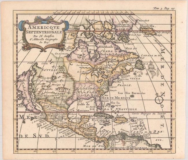
Auction 183, Lot 63
Subject: Colonial North America
Sanson, Nicolas
Americque Septentrionale par N. Sanson d'Abbeville Geographe du Roy, 1735
Size: 6.4 x 5.7 inches (16.3 x 14.5 cm)
Estimate: $350 - $425
Sold for: $500
Closed on 6/9/2021
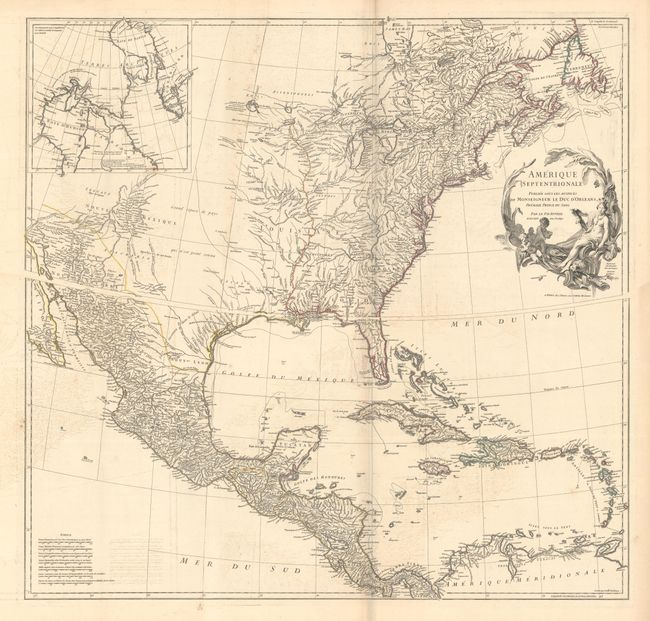
Auction 183, Lot 64
Subject: Colonial North America
Anville, Jean Baptiste Bourguignon d'
[On 2 Sheets] Amerique Septentrionale Publiee sous les Auspices de Monseigneur le Duc d'Orleans Premier Prince du Sang, 1746
Size: 34.2 x 17.9 inches (86.9 x 45.5 cm)
Estimate: $1,000 - $1,300
Sold for: $750
Closed on 6/9/2021
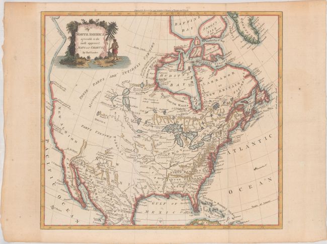
Auction 183, Lot 65
Subject: Colonial North America
Conder, Thomas
North America Agreeable to the Most Approved Maps and Charts, 1780
Size: 14.7 x 13.2 inches (37.3 x 33.5 cm)
Estimate: $400 - $475
Sold for: $325
Closed on 6/9/2021
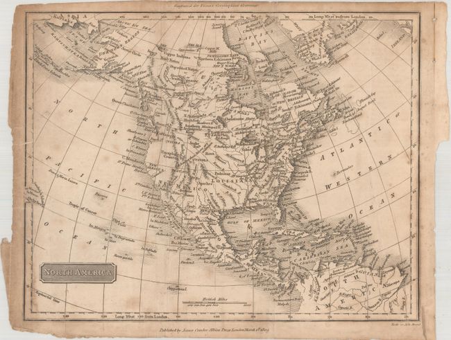
Auction 183, Lot 66
Subject: North America
North America, 1809
Size: 9.6 x 7.6 inches (24.4 x 19.3 cm)
Estimate: $60 - $80
NO RESERVE
Sold for: $110
Closed on 6/9/2021
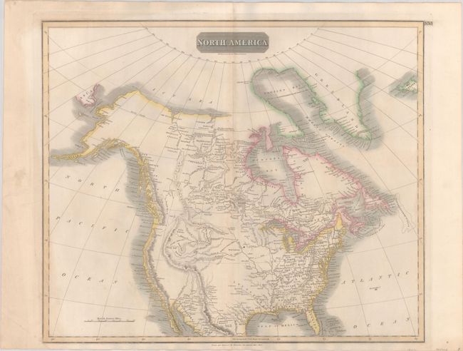
Auction 183, Lot 67
Subject: North America
Thomson, John
North America, 1814
Size: 23.4 x 19.7 inches (59.4 x 50 cm)
Estimate: $240 - $300
Sold for: $180
Closed on 6/9/2021
Auction 183, Lot 68
Subject: North America
Brue, Adrien Hubert
Carte Generale de l'Amerique Septentrionale, et des Iles qui en Dependent, 1828
Size: 20 x 14.3 inches (50.8 x 36.3 cm)
Estimate: $240 - $300
Sold for: $180
Closed on 6/9/2021
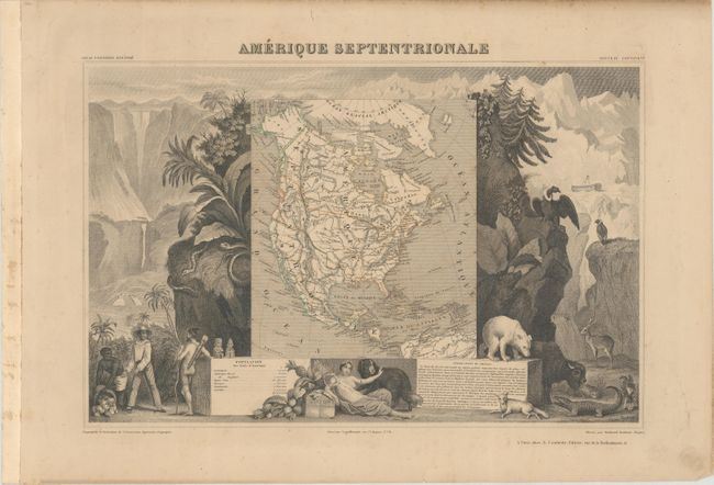
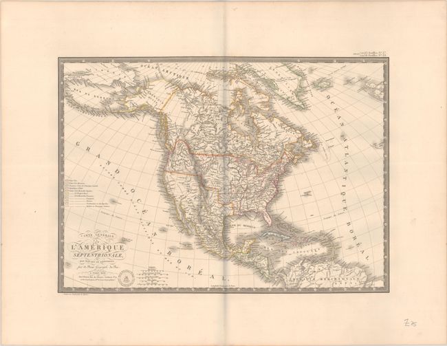
Auction 183, Lot 69
Subject: North America
Levasseur, Victor
Amerique Septentrionale, 1845
Size: 16.9 x 10.9 inches (42.9 x 27.7 cm)
Estimate: $140 - $170
Sold for: $100
Closed on 6/9/2021
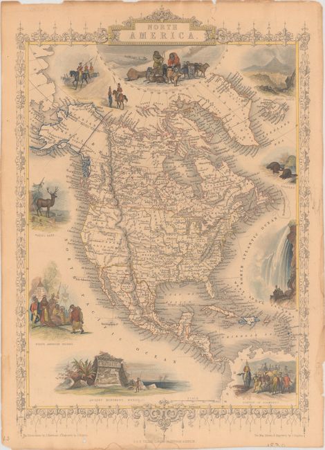
Auction 183, Lot 70
Subject: North America
Tallis, John
North America, 1850
Size: 9.6 x 14.1 inches (24.4 x 35.8 cm)
Estimate: $200 - $230
Sold for: $150
Closed on 6/9/2021
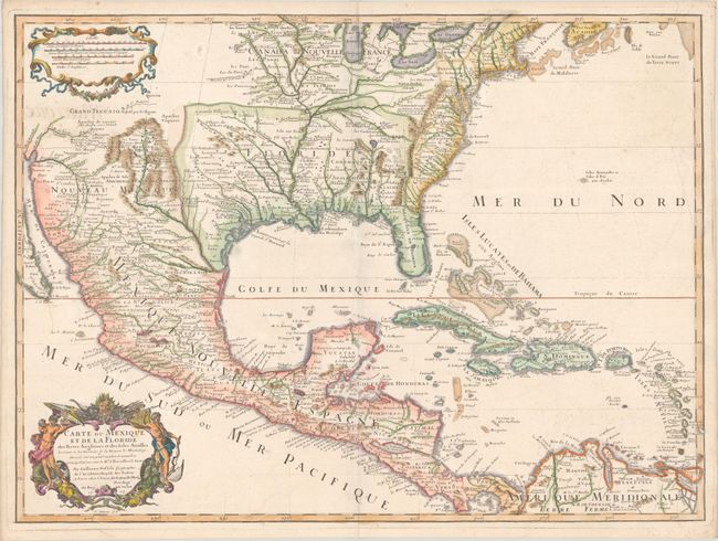
Auction 183, Lot 71
Subject: Colonial Eastern North America & West Indies
Delisle, Guillaume
Carte du Mexique et de la Floride des Terres Angloises et des Isles Antilles du Cours et des Environs de la Riviere de Mississipi..., 1703
Size: 25.3 x 18.6 inches (64.3 x 47.2 cm)
Estimate: $3,000 - $3,750
Landmark in American Cartography - First Printed Map to Accurately Depict the Mouth of the Mississippi River
Sold for: $2,200
Closed on 6/9/2021
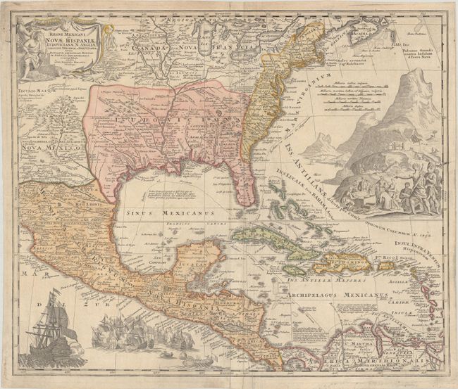
Auction 183, Lot 72
Subject: Colonial Eastern North America & West Indies
Homann, Johann Baptist
Regni Mexicani seu Novae Hispaniae Ludovicianae, N. Angliae, Carolinae, Virginiae et Pensylvaniae nec non Insularum Archipelagi Mexicani in America Septentrionali Accurata Tabula, 1720
Size: 22.1 x 18.6 inches (56.1 x 47.2 cm)
Estimate: $1,600 - $1,900
Homann's Decorative Map of Colonial America in the Era of the War of the Spanish Succession
Sold for: $1,500
Closed on 6/9/2021
Auction 183, Lot 73
Subject: Colonial Eastern North America & West Indies
Popple/Covens & Mortier
A Map of the British Empire in America with the French, Spanish and Hollandish Settlements Adjacent Thereto by Henry Popple, 1741
Size: 18.9 x 19.3 inches (48 x 49 cm)
Estimate: $3,000 - $3,750
Index Sheet of Popple's Map
Sold for: $2,200
Closed on 6/9/2021
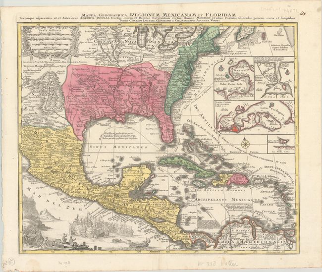
Auction 183, Lot 74
Subject: Colonial Eastern North America & West Indies
Lotter, Tobias Conrad
Mappa Geographica Regionem Mexicanam et Floridam Terrasque Adjacentes, ut et Anteriores Americae Insulas, Cursus Itidem et Reditus Navigantium Versus Flumen Missisipi..., 1760
Size: 22.4 x 18.5 inches (56.9 x 47 cm)
Estimate: $1,200 - $1,500
Lotter's Version of Delisle's Important Map
Sold for: $750
Closed on 6/9/2021
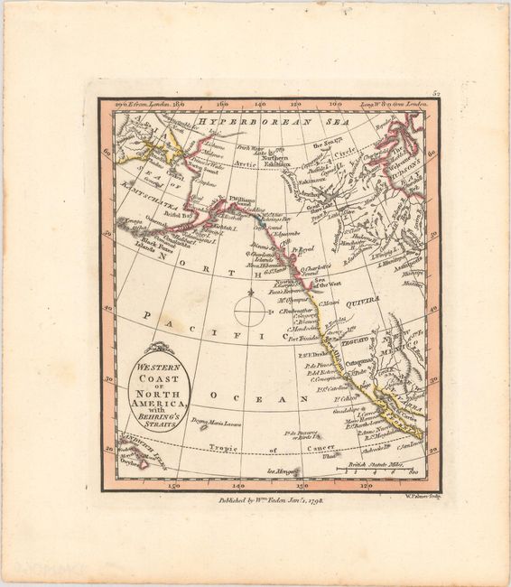
Auction 183, Lot 75
Subject: Western North America
Faden, William
Western Coast of North America, with Behring's Straits, 1798
Size: 4.1 x 4.8 inches (10.4 x 12.2 cm)
Estimate: $200 - $230
Sold for: $210
Closed on 6/9/2021
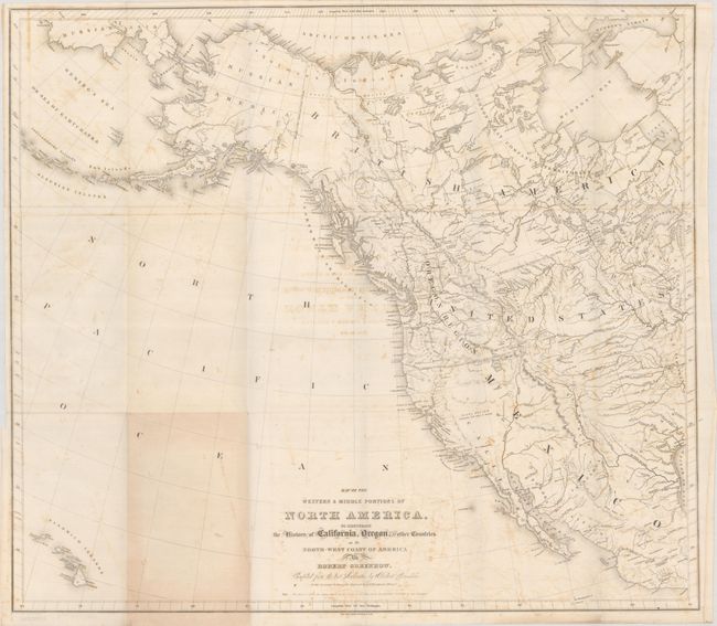
Auction 183, Lot 76
Subject: Western North America, Texas
Greenhow, Robert
Map of the Western & Middle Portions of North America, to Illustrate the History of California, Oregon, and the Other Countries on the North-west Coast of America, 1844
Size: 25.8 x 22.9 inches (65.5 x 58.2 cm)
Estimate: $275 - $350
Features the Republic of Texas with Washington as Capital
Sold for: $180
Closed on 6/9/2021
19 lots