Showing Featured Lots(remove filter)
Showing results for:Auction 182
Catalog Archive
57 lots
Page 1 of 2
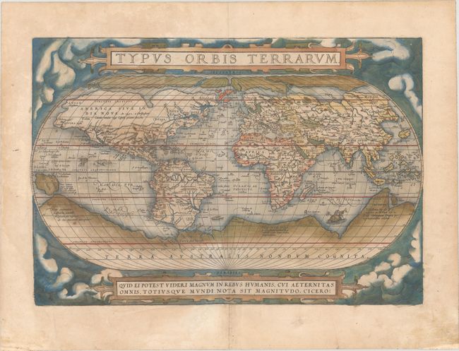
Auction 182, Lot 1
Subject: World
Ortelius, Abraham
Typus Orbis Terrarum, 1573
Size: 19.6 x 13.3 inches (49.8 x 33.8 cm)
Estimate: $5,500 - $6,500
Ortelius' Famous World Map - First Plate in Full Contemporary Color
Sold for: $4,250
Closed on 4/28/2021
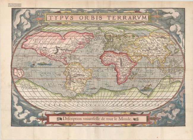
Auction 182, Lot 2
Subject: World
Belleforest, Francois
Typus Orbis Terrarum, 1575
Size: 19.5 x 13.2 inches (49.5 x 33.5 cm)
Estimate: $4,500 - $5,500
Scarce Woodcut Version of Ortelius’ World Map
Sold for: $3,250
Closed on 4/28/2021
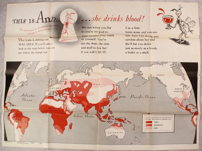
Auction 182, Lot 23
Subject: World, World War II
U.S. Gov't Printing Office
This Is Ann..... She Drinks Blood! [on verso] Newsmap Monday November 8, 1943..., 1943
Size: 45.8 x 33 inches (116.3 x 83.8 cm)
Estimate: $1,000 - $1,300
Rare Malaria Map Featuring Dr. Seuss Illustrations
Sold for: $600
Closed on 4/28/2021
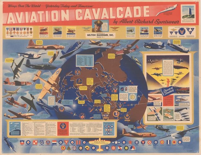
Auction 182, Lot 25
Subject: World, World War II
Wings Over the World... Yesterday, Today and Tomorrow Aviation Cavalcade by Albert Richard Sportswear, 1944
Size: 21.6 x 16.6 inches (54.9 x 42.2 cm)
Estimate: $1,200 - $1,500
Propaganda Map Promoting US Military Aviation During WWII
Unsold
Closed on 4/28/2021
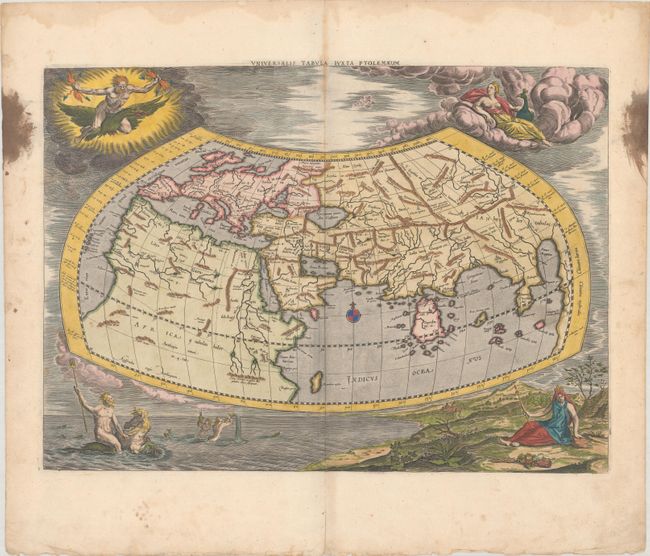
Auction 182, Lot 30
Subject: Ancient World
Ptolemy/Mercator
Universalis Tabula Iuxta Ptolemaeum, 1695
Size: 18.7 x 13.5 inches (47.5 x 34.3 cm)
Estimate: $1,800 - $2,100
Map of the Ancient World with Depictions of the Four Elements
Sold for: $1,150
Closed on 4/28/2021
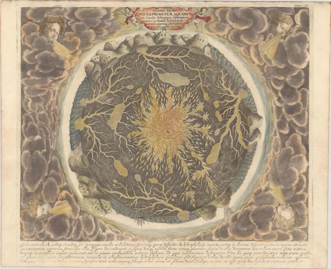
Auction 182, Lot 55
Subject: Cartographic Miscellany, Earth
Kircher, Athanasius
Systema Ideale quo Exprimitur, Aquarum per Canales Hydragogos Subterraneos ex Mari et in Montium Hydrophylacia Protrusio..., 1682
Size: 15.9 x 12.9 inches (40.4 x 32.8 cm)
Estimate: $1,600 - $1,900
Fascinating Cross-Section of the Earth
Sold for: $1,200
Closed on 4/28/2021
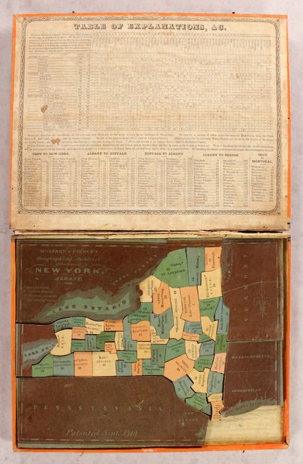
Auction 182, Lot 61
Subject: Cartographic Miscellany, Puzzle, New York
McCleary & Pierce, Samuel & John
McCleary & Pierce's Geographical Analysis of the State of New York, 1850
Size: 10.6 x 8.2 inches (26.9 x 20.8 cm)
Estimate: $400 - $500
Early Puzzle Map of New York
Sold for: $400
Closed on 4/28/2021
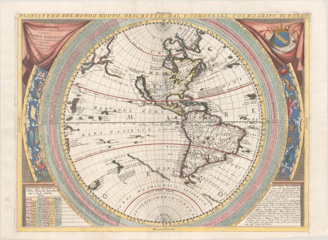
Auction 182, Lot 70
Subject: Western Hemisphere - America
Coronelli, Vincenzo Maria
Planisfero del Mondo Nuovo..., 1697
Size: 24.1 x 18.1 inches (61.2 x 46 cm)
Estimate: $2,000 - $2,300
Coronelli's Map of the New World with Interesting Cartography
Sold for: $1,700
Closed on 4/28/2021
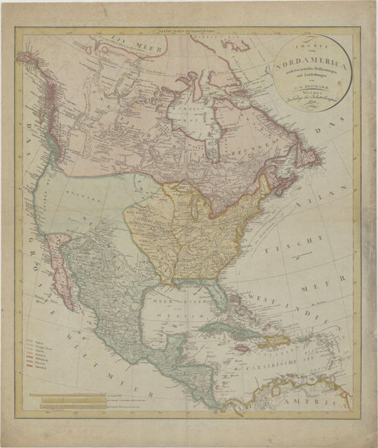
Auction 182, Lot 96
Subject: North America, Franklinia
Reichard, Christian Gottlieb Theoph
Charte von Nordamerica nach den Neuesten Bestimmungen und Entdeckungen, 1802
Size: 20.7 x 23.4 inches (52.6 x 59.4 cm)
Estimate: $1,200 - $1,500
German Map of North America Featuring the Short-Lived Franklin
Sold for: $900
Closed on 4/28/2021
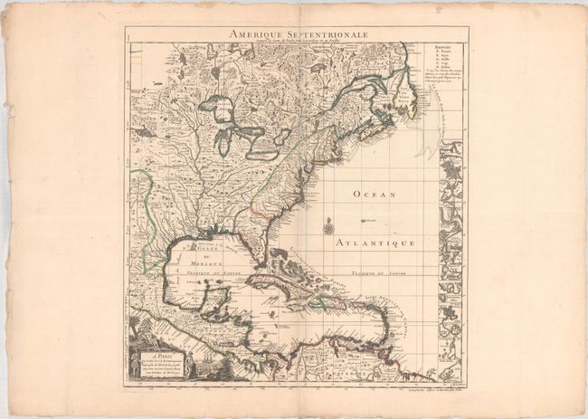
Auction 182, Lot 107
Subject: Colonial North America & West Indies
Popple/Le Rouge
Amerique Septentrionale Suivant la Carte de Pople Faite a Londres en 20 Feuilles, 1742
Size: 19.1 x 20.3 inches (48.5 x 51.6 cm)
Estimate: $2,200 - $2,500
French Edition of Popple's Index Sheet
Sold for: $1,600
Closed on 4/28/2021
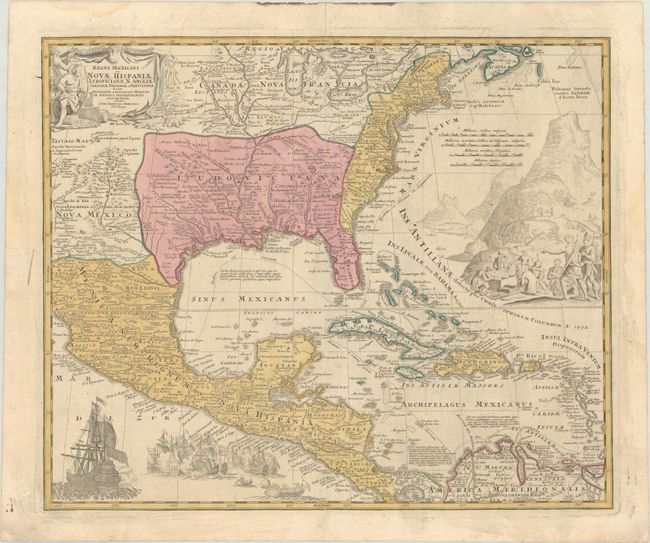
Auction 182, Lot 108
Subject: Colonial Eastern North America & West Indies
Homann, Johann Baptist
Regni Mexicani seu Novae Hispaniae Ludovicianae, N. Angliae, Carolinae, Virginiae et Pensylvaniae nec non Insularum Archipelagi Mexicani in America Septentrionali Accurata Tabula, 1720
Size: 22.5 x 18.7 inches (57.2 x 47.5 cm)
Estimate: $1,600 - $1,900
Homann's Decorative Map of Colonial America in the Era of the War of the Spanish Succession
Sold for: $1,200
Closed on 4/28/2021
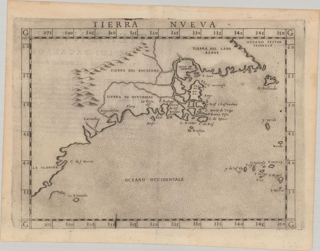
Auction 182, Lot 120
Subject: Eastern United States & Canada
Ruscelli, Girolamo
Tierra Nueva, 1574
Size: 9.6 x 7 inches (24.4 x 17.8 cm)
Estimate: $1,200 - $1,500
Ruscelli's Map of the East Coast
Sold for: $950
Closed on 4/28/2021
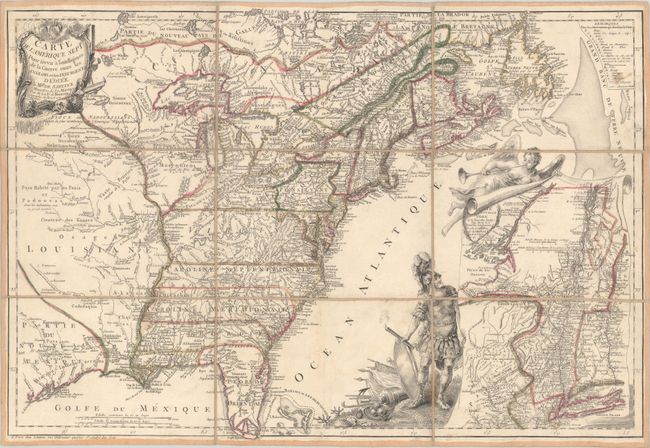
Auction 182, Lot 122
Subject: Colonial Eastern United States & Canada
Beaurain, Jean Chev. De
Carte de l'Amerique Septle. pour Servir a l'Intelligence de la Guerre Entre les Anglois et les Insurgents, 1777
Size: 24.5 x 16.8 inches (62.2 x 42.7 cm)
Estimate: $7,000 - $8,500
Important Map Published Just Prior to France's Entrance in the Revolutionary War
Sold for: $5,500
Closed on 4/28/2021
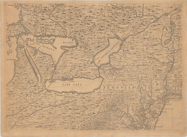
Auction 182, Lot 125
Subject: Colonial Northeastern United States & Canada, Great Lakes
Popple, Henry
[A Map of the British Empire in America (Sheet 6) - Great Lakes and Mid-Atlantic Regions], 1734
Size: 27.1 x 19.4 inches (68.8 x 49.3 cm)
Estimate: $2,000 - $2,300
Popple's Epic Map - Great Lakes & Northeast Sheet
Sold for: $2,300
Closed on 4/28/2021
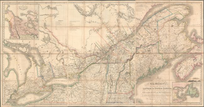
Auction 182, Lot 129
Subject: Northeastern United States & Canada
Bouchette, Joseph
[On 3 Sheets] To His Most Excellent Majesty King William IVth This Map of the Provinces of Lower & Upper Canada, Nova Scotia, New Brunswick, Newfoundland & Prince Edwards Island, with a Large Section of the United States..., 1831
Size: 24.6 x 37.9 inches (62.5 x 96.3 cm)
Estimate: $6,500 - $8,000
Rare and Important Map Promoting Canadian Immigration
Sold for: $7,000
Closed on 4/28/2021
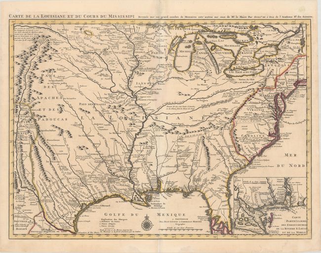
Auction 182, Lot 152
Subject: Colonial Eastern United States, Louisiana Territory
Delisle/Covens & Mortier
Carte de la Louisiane et du Cours du Mississipi Dressee sur un Grand Nombre de Memoires Entr'autres sur ceux de Mr. le Maire, 1730
Size: 23.8 x 17.3 inches (60.5 x 43.9 cm)
Estimate: $1,900 - $2,200
Delisle's Influential Map of the Louisiana Territory
Sold for: $1,600
Closed on 4/28/2021
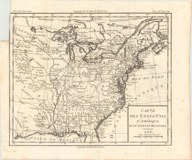
Auction 182, Lot 154
Subject: Eastern United States, Franklin
Brion de la Tour, Louis
Carte des Etats-Unis d'Amerique et du Cours du Mississipi, 1788
Size: 10.6 x 8.7 inches (26.9 x 22.1 cm)
Estimate: $900 - $1,100
One of the Earliest Maps to Feature the State of Franklin
Sold for: $650
Closed on 4/28/2021
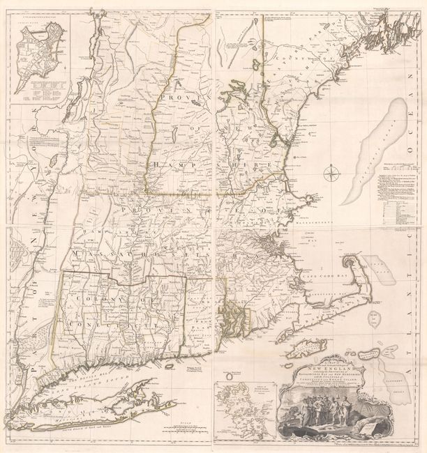
Auction 182, Lot 165
Subject: Colonial New England United States
Jefferys, Thomas
[On 4 Sheets] A Map of the Most Inhabited Part of New England, Containing the Provinces of Massachusets Bay and New Hampshire, with the Colonies of Conecticut and Rhode Island..., 1755
Size: 19.2 x 20.3 inches (48.8 x 51.6 cm)
Estimate: $8,000 - $9,500
Rare State of Jefferys' Influential Map of New England in Contemporary Color
Unsold
Closed on 4/28/2021
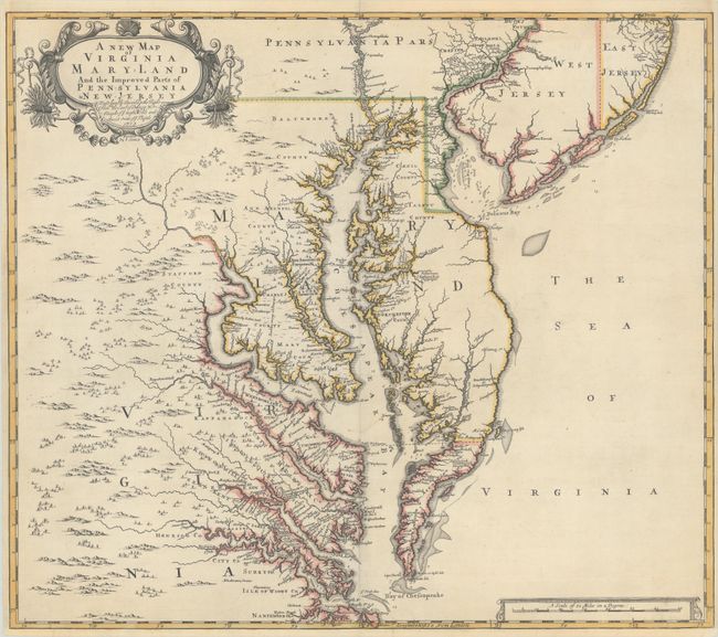
Auction 182, Lot 168
Subject: Colonial Mid-Atlantic United States
Browne/Senex
A New Map of Virginia Mary-land and the Improved Parts of Pennsylvania & New Jersey..., 1719
Size: 21.8 x 19.1 inches (55.4 x 48.5 cm)
Estimate: $3,500 - $4,500
Map of Chesapeake Bay Based on Landmark Herrman Map
Sold for: $4,500
Closed on 4/28/2021
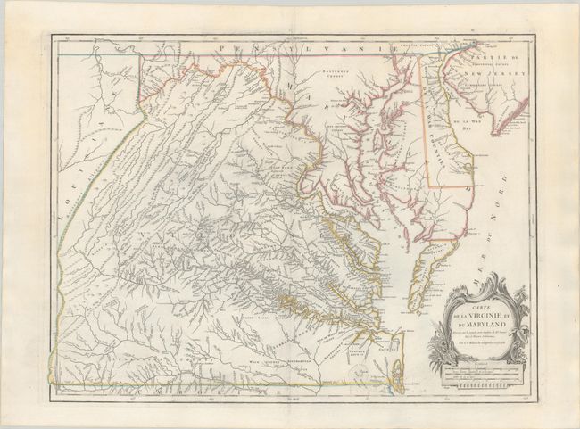
Auction 182, Lot 170
Subject: Mid-Atlantic United States
Robert de Vaugondy, Didier
Carte de la Virginie et du Maryland Dressee sur la Grande Carte Angloise de Mrs. Josue Fry et Pierre Jefferson, 1793
Size: 25.2 x 19 inches (64 x 48.3 cm)
Estimate: $1,200 - $1,500
An Essential Map of Virginia and Maryland
Sold for: $900
Closed on 4/28/2021
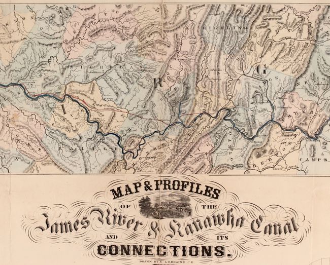
Auction 182, Lot 173
Subject: Mid-Atlantic United States, James River
Map & Profiles of the James River & Kanawha Canal and its Connections, 1857
Size: 58 x 24.5 inches (147.3 x 62.2 cm)
Estimate: $3,250 - $4,000
Map of the Proposed James River and Kanawha Canal
Unsold
Closed on 4/28/2021
Auction 182, Lot 175
Subject: Colonial Southeast United States
Popple, Henry
[A Map of the British Empire in America (Sheet 10) - Southeast Region], 1734
Size: 26.7 x 19.3 inches (67.8 x 49 cm)
Estimate: $2,000 - $2,300
Popple's Epic Map - Southeastern Sheet
Sold for: $1,500
Closed on 4/28/2021
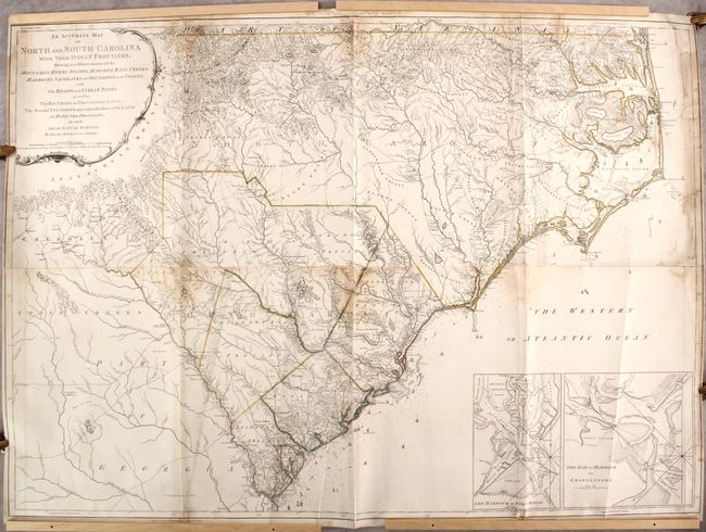
Auction 182, Lot 177
Subject: Colonial Southeast United States
Mouzon, Henry, Jr.
An Accurate Map of North and South Carolina with Their Indian Frontiers, Shewing in a Distinct Manner All the Mountains, Rivers, Swamps, Marshes, Bays, Creeks, Harbours, Sandbanks and Soundings on the Coasts..., 1775
Size: 55.8 x 39.6 inches (141.7 x 100.6 cm)
Estimate: $10,000 - $13,000
Mouzon's Foundation Map of the Carolinas - Second State
Sold for: $5,000
Closed on 4/28/2021
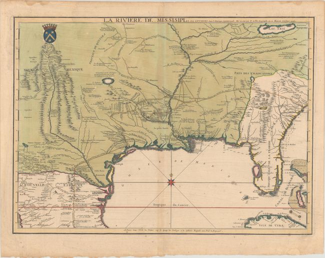
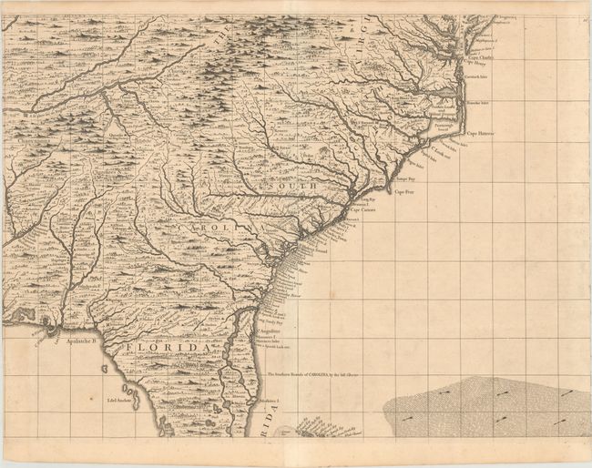
Auction 182, Lot 183
Subject: Colonial Southern United States
Fer, Nicolas de
La Riviere de Missisipi, et ses Environs, dans l'Amerique Septentrionale..., 1715
Size: 25.3 x 18.3 inches (64.3 x 46.5 cm)
Estimate: $20,000 - $25,000
Very Rare First State of De Fer's Important Map of the Lower Mississippi Valley
Sold for: $30,500
Closed on 4/28/2021
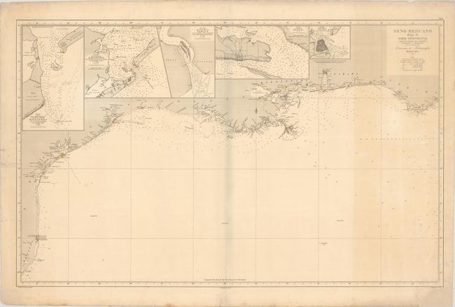
Auction 182, Lot 187
Subject: Southern United States, Gulf Coast
Direccion de Hidrografia
Seno Mejicano Hoja II. Parte Setentrional Segun los Trabajos Mas Modernos Nacionales y Estrangeros, 1867
Size: 38.2 x 23.9 inches (97 x 60.7 cm)
Estimate: $1,400 - $1,700
Uncommon Spanish Chart of the Gulf Coast
Sold for: $700
Closed on 4/28/2021
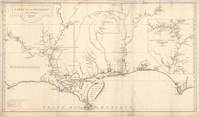
Auction 182, Lot 188
Subject: Colonial Gulf Coast
Anville, Jean Baptiste Bourguignon d'
Carte de la Louisiane par Le Sr. D'Anville Dressee en Mai 1732. Publiee en 1752., 1752
Size: 36.3 x 20.4 inches (92.2 x 51.8 cm)
Estimate: $1,500 - $1,800
An Early, Detailed Depiction of the Gulf Coast
Sold for: $1,100
Closed on 4/28/2021
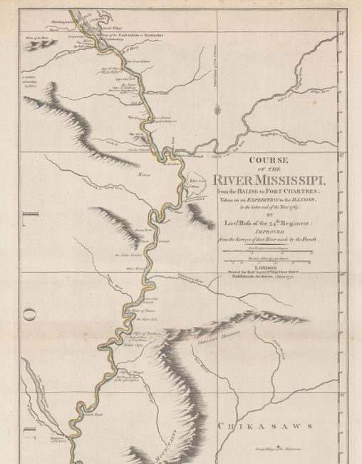
Auction 182, Lot 194
Subject: Colonial Central United States, Mississippi River
Ross, John (Lt.)
Course of the River Mississipi, from the Balise to Fort Chartres; Taken on an Expedition to the Illinois, in the Latter End of the Year 1765, 1775
Size: 13.8 x 44.4 inches (35.1 x 112.8 cm)
Estimate: $3,250 - $4,000
First English Map of the Lower Mississippi River
Sold for: $3,250
Closed on 4/28/2021
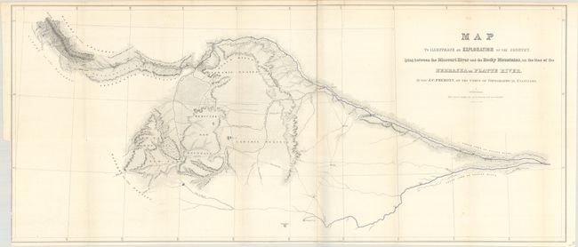
Auction 182, Lot 200
Subject: Western United States
Fremont/Preuss
Map to Illustrate an Exploration of the Country, Lying Between the Missouri River and the Rocky Mountains... [with report] Report from the Secretary of War, Communicating ... Lieut. Fremont's Report of His Exploring Expedition to the Rocky Mountains, 1843
Size: 32.7 x 13.9 inches (83.1 x 35.3 cm)
Estimate: $900 - $1,100
First Printing of Fremont's First Expedition to the Rockies
Sold for: $700
Closed on 4/28/2021
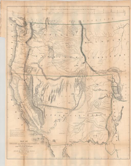
Auction 182, Lot 202
Subject: Western United States
Fremont/Preuss
Map of Oregon and Upper California from the Surveys of John Charles Fremont and Other Authorities, 1848
Size: 26.6 x 33 inches (67.6 x 83.8 cm)
Estimate: $1,200 - $1,500
Fremont's Map of the American West
Sold for: $950
Closed on 4/28/2021
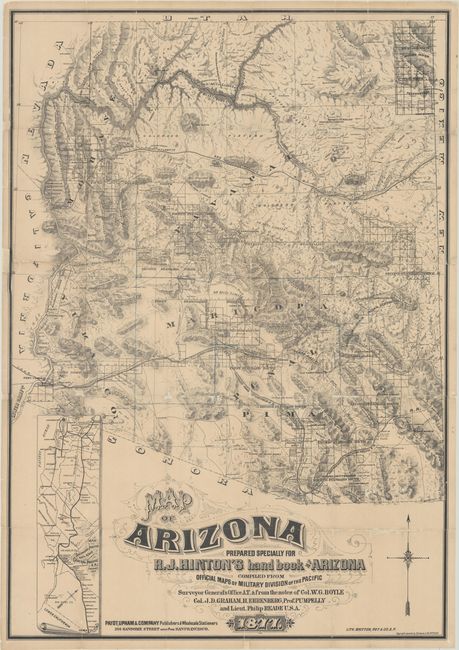
Auction 182, Lot 226
Subject: Arizona
Hinton, Richard J.
Map of Arizona Prepared Specially for R.J. Hinton's Hand Book of Arizona Compiled from Official Maps of Military Division of the Pacific… [with] The Hand-book to Arizona: Its Resources, History, Towns, Mines, Ruins and Scenery..., 1877
Size: 24.1 x 34.6 inches (61.2 x 87.9 cm)
Estimate: $5,500 - $7,000
One of the Earliest Large-Scale Maps of Arizona Territory
Unsold
Closed on 4/28/2021
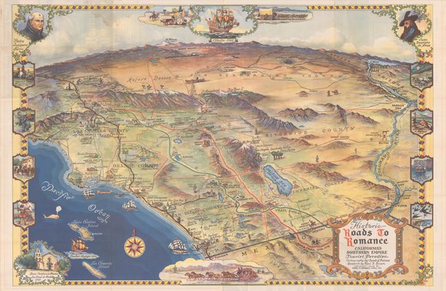
Auction 182, Lot 245
Subject: Southern California
Historic Roads to Romance California's Southern Empire, 1946
Size: 32.9 x 22 inches (83.6 x 55.9 cm)
Estimate: $275 - $350
First Edition
Sold for: $200
Closed on 4/28/2021
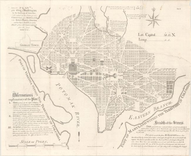
Auction 182, Lot 253
Subject: Washington, D.C.
Ellicott, Andrew
Plan of the City of Washington in the Territory of Columbia Ceded by the States of Virginia and Maryland to the United States of America and By Them Established as the Seat of Their Government After the Year MDCCC, 1796
Size: 19.4 x 15.5 inches (49.3 x 39.4 cm)
Estimate: $2,400 - $3,000
Scarce Scottish Edition Based on Ellicott's Plan of Washington, D.C.
Sold for: $1,500
Closed on 4/28/2021
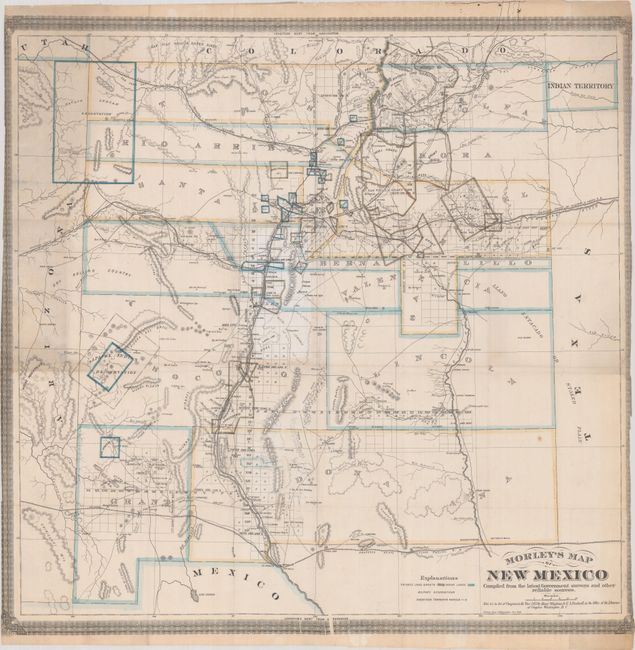
Auction 182, Lot 293
Subject: New Mexico
Morley's Map of New Mexico Compiled from the Latest Government Surveys and Other Reliable Sources, 1873
Size: 24.8 x 24.2 inches (63 x 61.5 cm)
Estimate: $10,000 - $13,000
One of the Earliest Maps Dedicated to New Mexico Territory
Unsold
Closed on 4/28/2021
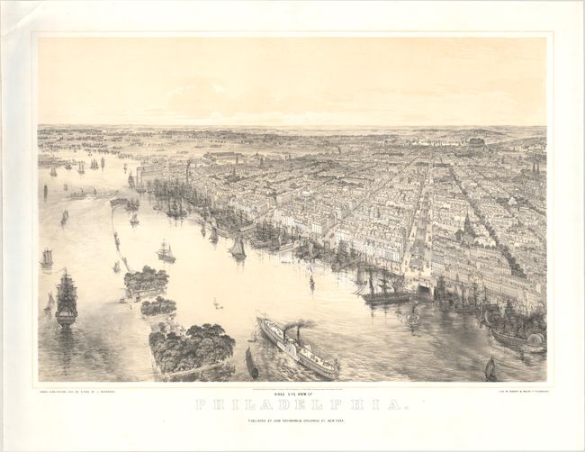
Auction 182, Lot 313
Subject: Philadelphia, Pennsylvania
Bachmann, John
Birds Eye View of Philadelphia, 1850
Size: 27.3 x 18.5 inches (69.3 x 47 cm)
Estimate: $3,250 - $4,250
Stunning View of Philadelphia by John Bachmann
Sold for: $2,400
Closed on 4/28/2021
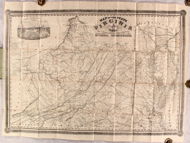
Auction 182, Lot 338
Subject: Virginia, Civil War
West & Johnston
Map of the State of Virginia Containing the Counties, Principal Towns, Railroads, Rivers, Canals & all Other Internal Improvements, 1862
Size: 37 x 25.5 inches (94 x 64.8 cm)
Estimate: $9,500 - $12,000
Rare Civil War Map Based on Bucholtz Map of Virginia
Sold for: $5,000
Closed on 4/28/2021
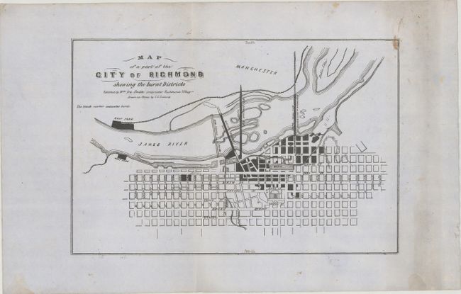
Auction 182, Lot 340
Subject: Richmond, Virginia
Map of a Part of the City of Richmond Showing the Burnt Districts, 1865
Size: 12.5 x 8.2 inches (31.8 x 20.8 cm)
Estimate: $2,400 - $3,000
Rare Map of Richmond after Confederate Burning of the City
Sold for: $1,800
Closed on 4/28/2021
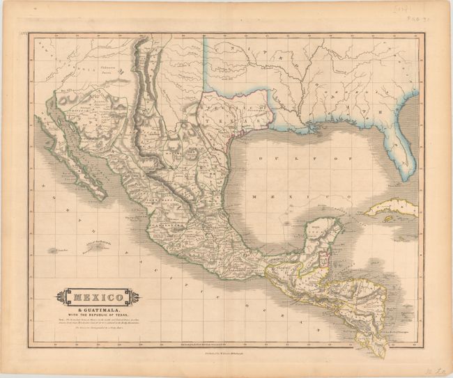
Auction 182, Lot 351
Subject: Southern United States, Mexico & Central America, Texas
Lizars, William Home
Mexico & Guatimala, with the Republic of Texas, 1838
Size: 19.7 x 16.4 inches (50 x 41.7 cm)
Estimate: $1,000 - $1,300
One of the Few Maps to Include "Republic" in the Title
Sold for: $950
Closed on 4/28/2021
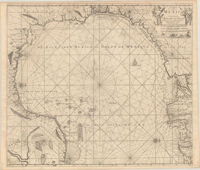
Auction 182, Lot 385
Subject: Gulf of Mexico
Keulen, Gerard van
Pas Kaart van de Golff van Mexico, 1734
Size: 23.1 x 20.3 inches (58.7 x 51.6 cm)
Estimate: $1,400 - $1,700
The First Sea Chart of the Western Portion of the Gulf of Mexico
Sold for: $900
Closed on 4/28/2021
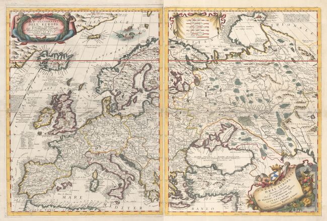
Auction 182, Lot 452
Subject: Europe
Coronelli, Vincenzo Maria
[Lot of 2] Parte Occidentale dell' Europa... [and] Parte Orientale dell' Europa..., 1697
Size: 18.1 x 24.4 inches (46 x 62 cm)
Estimate: $2,300 - $2,750
Decorative Two-Sheet Map of Europe
Sold for: $1,700
Closed on 4/28/2021
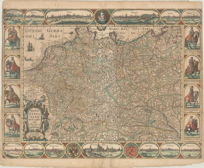
Auction 182, Lot 521
Subject: Central Europe, Germany
Hondius/Jansson
Nova Germaniae Descriptio, 1632
Size: 21.8 x 16.3 inches (55.4 x 41.4 cm)
Estimate: $1,800 - $2,300
Jansson's Rare Carte-a-Figures Map of the German Empire in Contemporary Color
Sold for: $1,100
Closed on 4/28/2021
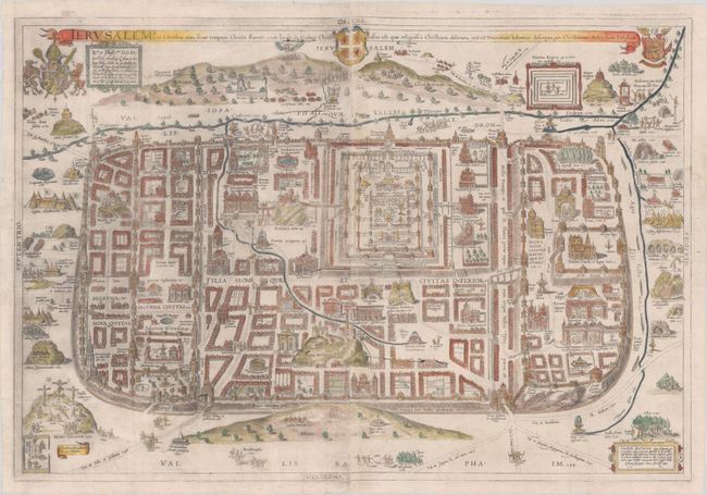
Auction 182, Lot 650
Subject: Jerusalem, Holy Land
Adrichom, Christian van
Ierusalem I., et Suburbia eius, Sicut Tempore Christi Floruit, cum Locis, in Quibus Christus Passus est…, 1584
Size: 29.1 x 19.7 inches (73.9 x 50 cm)
Estimate: $2,000 - $2,400
First Edition of Adrichom's Influential Bird's-Eye Plan of Jerusalem
Sold for: $1,500
Closed on 4/28/2021
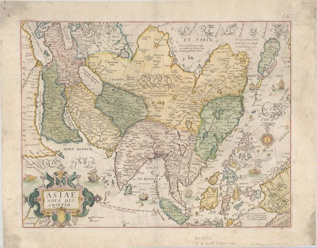
Auction 182, Lot 667
Subject: Asia
Mazza, Giovanni Battista
Asiae Nova Descriptio, 1590
Size: 18.4 x 14.2 inches (46.7 x 36.1 cm)
Estimate: $6,000 - $7,500
First Map to Accurately Show Luzon in Philippines
Sold for: $6,000
Closed on 4/28/2021
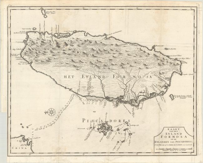
Auction 182, Lot 681
Subject: Taiwan
Valentyn, Francois
Kaart van het Eyland Formosa en de Eylanden van Piscadores, 1726
Size: 18.1 x 11.9 inches (46 x 30.2 cm)
Estimate: $3,750 - $4,500
Rare and Desirable Early Map of Taiwan
Sold for: $2,750
Closed on 4/28/2021
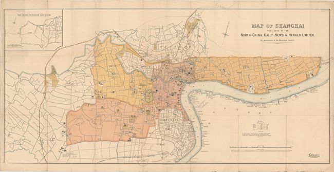
Auction 182, Lot 682
Subject: Shanghai, China
Map of Shanghai Published by the North-China Daily News & Herald, Limited..., 1918
Size: 58.3 x 28 inches (148.1 x 71.1 cm)
Estimate: $7,000 - $9,000
Rare Map of Shanghai International Settlement
Unsold
Closed on 4/28/2021
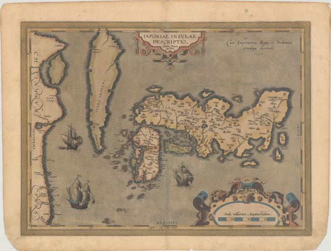
Auction 182, Lot 685
Subject: Japan & Korea
Ortelius, Abraham
Iaponiae Insulae Descriptio. Ludoico Teisera Auctore, 1595
Size: 19 x 14 inches (48.3 x 35.6 cm)
Estimate: $2,000 - $2,300
Ortelius' Influential Map of Japan
Sold for: $1,500
Closed on 4/28/2021
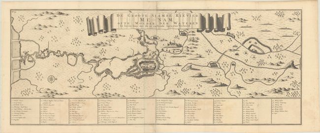
Auction 182, Lot 691
Subject: Chao Phraya River, Thailand
Valentyn, Francois
De Groote Siamse Rievier Me-Nam ofte Moeder der Wateren in Haren Loop met de in Vallende Spruyten Verbeeld, 1726
Size: 29.3 x 11.6 inches (74.4 x 29.5 cm)
Estimate: $800 - $950
Rare Map of Thailand Featuring Bangkok
Sold for: $2,750
Closed on 4/28/2021
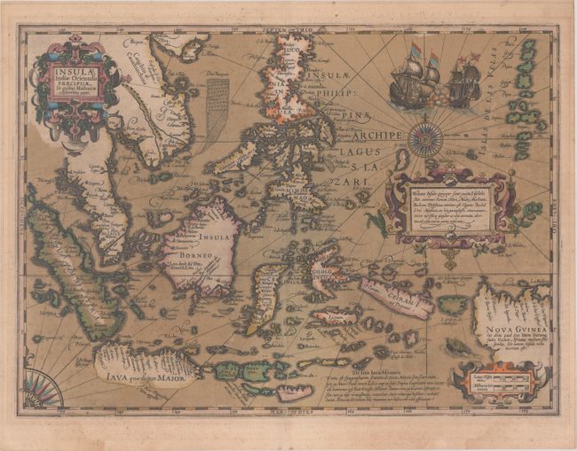
Auction 182, Lot 693
Subject: East Indies - Indonesia
Mercator/Hondius
Insulae Indiae Orientalis Praecipuae, in Quibus Moluccae Celeberrimae Sunt, 1613
Size: 18.8 x 13.5 inches (47.8 x 34.3 cm)
Estimate: $2,200 - $2,500
Hondius' Decorative Map of the Spice Islands in Full Contemporary Color
Unsold
Closed on 4/28/2021
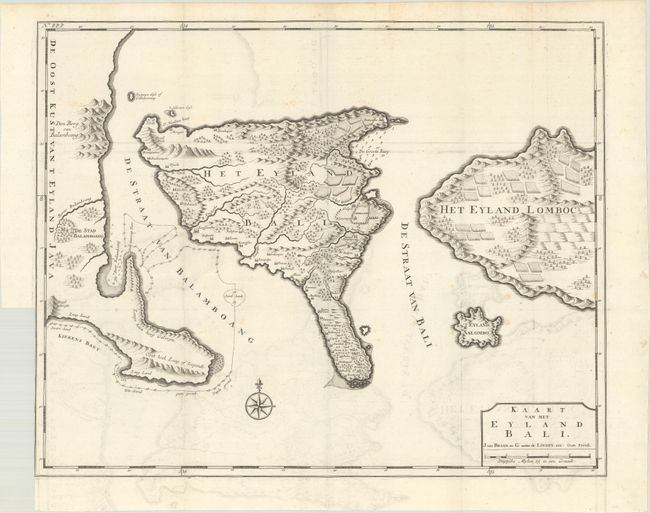
Auction 182, Lot 695
Subject: Bali, Indonesia
Valentyn, Francois
Kaart van het Eyland Bali, 1726
Size: 22.1 x 17.7 inches (56.1 x 45 cm)
Estimate: $1,100 - $1,400
Striking Early Map of Bali
Sold for: $800
Closed on 4/28/2021
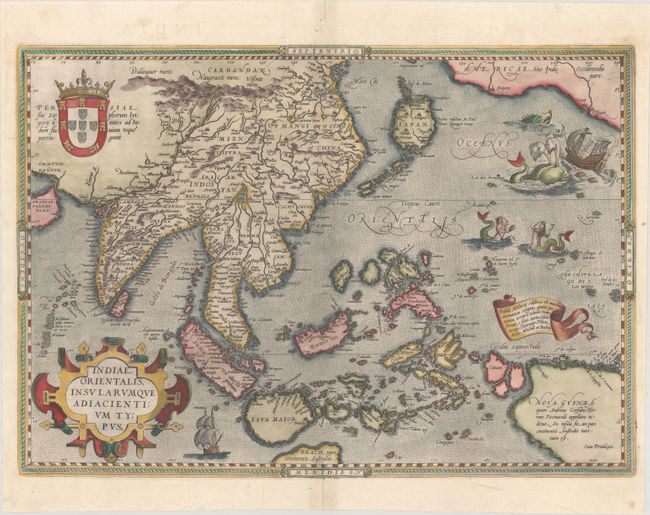
Auction 182, Lot 701
Subject: Southern & Southeast Asia
Ortelius, Abraham
Indiae Orientalis, Insularumque Adiacientium Typus, 1592
Size: 19.6 x 13.7 inches (49.8 x 34.8 cm)
Estimate: $2,750 - $3,500
Ortelius' Important Map of Southeast Asia
Sold for: $2,000
Closed on 4/28/2021
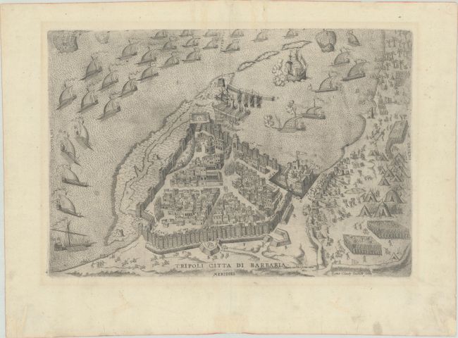
Auction 182, Lot 720
Subject: Tripoli, Libya
Lafreri, Antonio
Tripoli Citta di Barbaria, 1602
Size: 16.6 x 11.5 inches (42.2 x 29.2 cm)
Estimate: $1,000 - $1,400
Rare Lafreri View of Tripoli
Sold for: $500
Closed on 4/28/2021
57 lots
Page 1 of 2