Showing Featured Lots(remove filter)
Showing results for:Auction 179
Catalog Archive
62 lots
Page 1 of 2
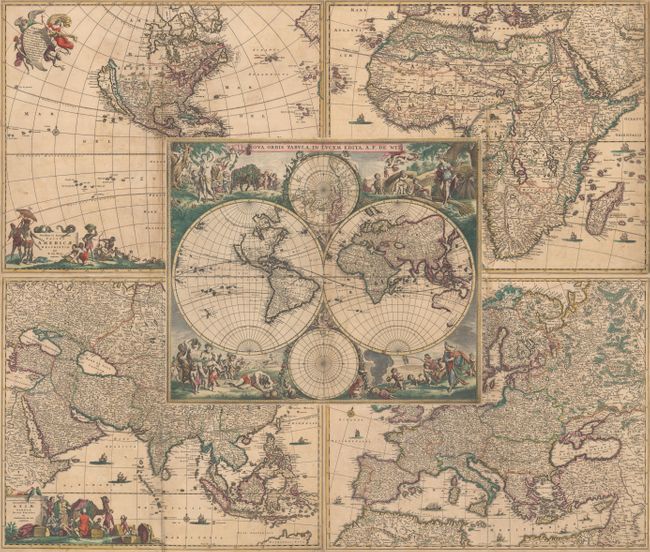
Auction 179, Lot 1
Subject: World & Continents
Wit, Frederick de
[Lot of 5] Nova Orbis Tabula, in Lucem Edita [and] Novissima et Accuratissima Totius Americae Descriptio [and] Totius Africae Accuratissima Tabula [and] Accuratissima Totius Asiae Tabula... [and] Nova et Accurata Totius Europae Descriptio, 1680
Size: 22.7 x 19.2 inches (57.7 x 48.8 cm)
Estimate: $8,000 - $9,500
Attractive Matched Set from the Golden Age of Dutch Cartography
Sold for: $6,000
Closed on 9/16/2020
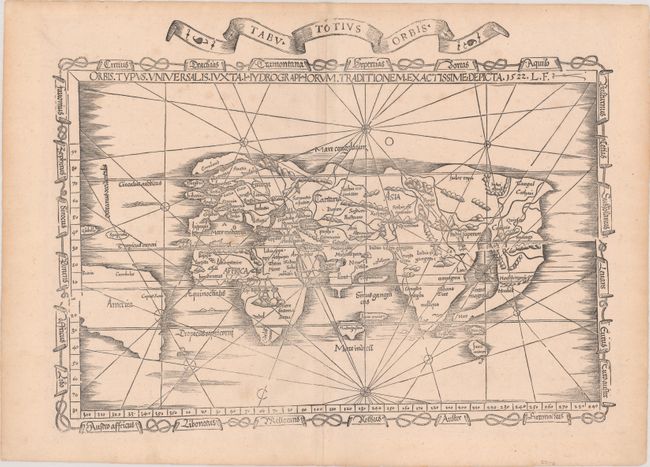
Auction 179, Lot 2
Subject: World
Ptolemy/Fries
Orbis Typus Universalis Iuxta Hydrographorum Traditionem Exactissime Depicta, 1522
Size: 19 x 13.9 inches (48.3 x 35.3 cm)
Estimate: $6,000 - $7,500
One of the First Ptolemaic Maps to Name America
Sold for: $4,500
Closed on 9/16/2020
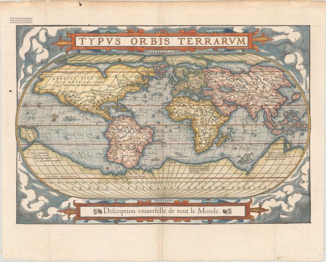
Auction 179, Lot 4
Subject: World
Belleforest, Francois
Typus Orbis Terrarum, 1575
Size: 19.5 x 13.2 inches (49.5 x 33.5 cm)
Estimate: $4,500 - $5,500
Scarce Woodcut Version of Ortelius’ World Map
Unsold
Closed on 9/16/2020
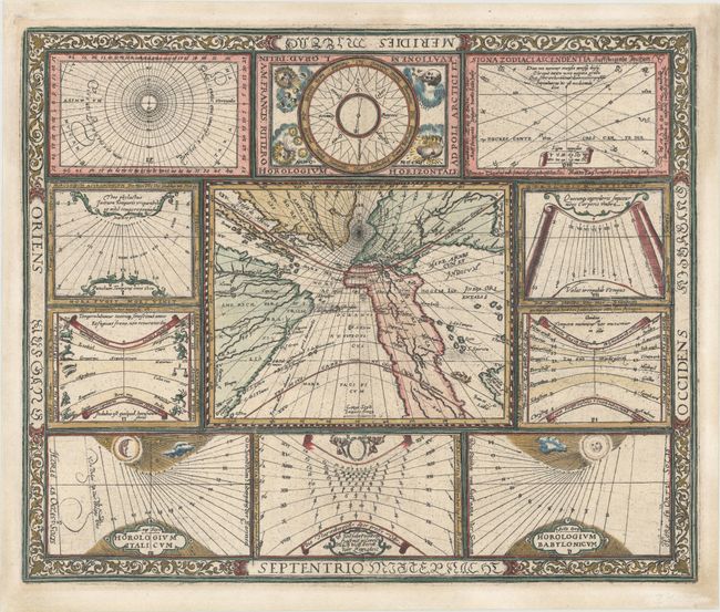
Auction 179, Lot 6
Subject: World
Ritter, Franz
[Untitled - World and Horological Diagrams], 1607
Size: 13.6 x 11.2 inches (34.5 x 28.4 cm)
Estimate: $3,250 - $4,000
Ritter's Unusual Sun-Dial World Map - First State
Unsold
Closed on 9/16/2020
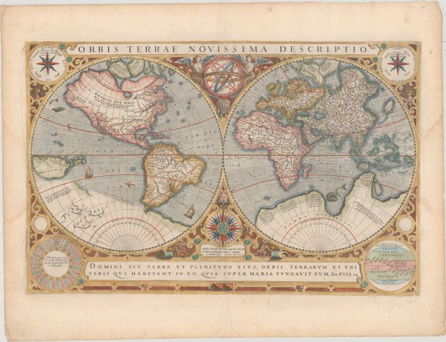
Auction 179, Lot 8
Subject: World
Hondius/Le Clerc
Orbis Terrae Novissima Descriptio, 1633
Size: 19.9 x 12.9 inches (50.5 x 32.8 cm)
Estimate: $4,750 - $6,000
Le Clerc's Decorative World Map Engraved by Hondius
Sold for: $3,400
Closed on 9/16/2020
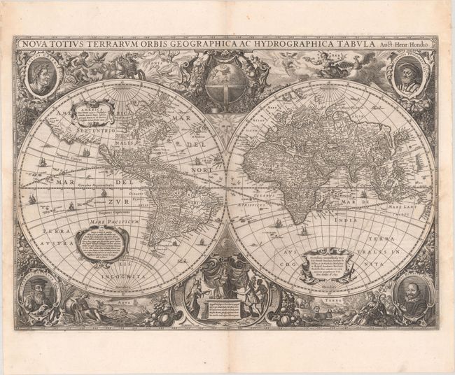
Auction 179, Lot 9
Subject: World
Hondius/Jansson
Nova Totius Terrarum Orbis Geographica ac Hydrographica Tabula, 1639
Size: 21.4 x 14.9 inches (54.4 x 37.8 cm)
Estimate: $8,000 - $9,500
Henricus Hondius' Baroque-Style World Map
Sold for: $6,000
Closed on 9/16/2020
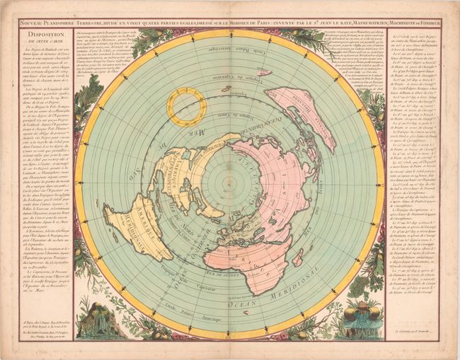
Auction 179, Lot 20
Subject: World
Le Raye, Jean
Nouveau Planisphere Terrestre, Divise en Vingt Quatre Parties Egales, Dresse sur le Meridien de Paris, 1762
Size: 25.6 x 19.8 inches (65 x 50.3 cm)
Estimate: $2,400 - $3,000
Rare World Map on North Polar Projection with Large Sea of the West
Sold for: $2,100
Closed on 9/16/2020
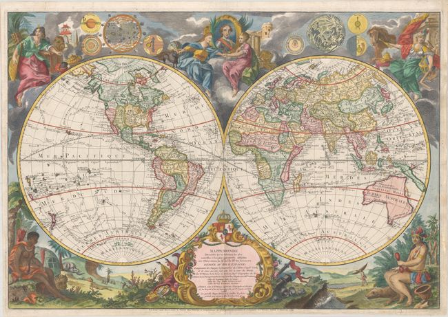
Auction 179, Lot 25
Subject: World
Brion de la Tour/Desnos
Mappemonde Dressee sur les Relations les Plus Nouvelles et les Plus Approuvees Assujeties aux Observations de Mrs. de l'Ac. Rle. des Sciences..., 1786
Size: 30.1 x 20.8 inches (76.5 x 52.8 cm)
Estimate: $2,750 - $3,500
Scarce Map Featuring Interesting Cartography in the Northwest
Sold for: $5,000
Closed on 9/16/2020
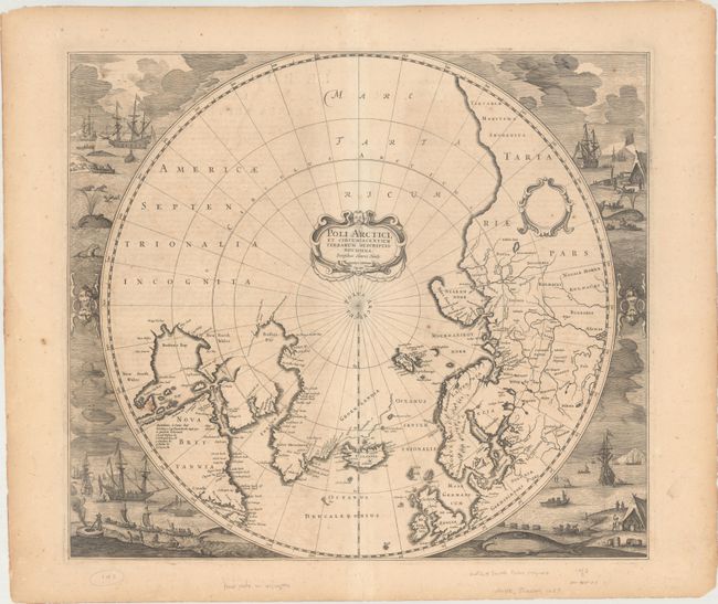
Auction 179, Lot 38
Subject: Polar
Hondius, Henricus
[Lot of 2] Poli Arctici, et Circumiacentium Terrarum Descriptio Novissima [and] Polus Antarcticus, 1639
Size: 19.4 x 17 inches (49.3 x 43.2 cm)
Estimate: $2,400 - $3,000
Magnificent Polar Maps Surrounded by Engraved Scenes
Sold for: $1,800
Closed on 9/16/2020
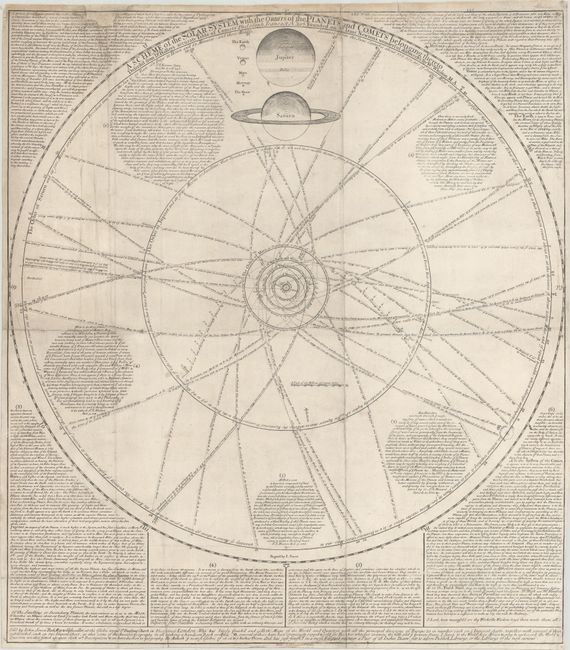
Auction 179, Lot 48
Subject: Solar System
Senex, John
A Scheme of the Solar System with the Orbits of the Planets and Comets Belonging Thereto, Describ'd from Dr. Halley's Accurate Table of Comets..., 1724
Size: 23.8 x 27 inches (60.5 x 68.6 cm)
Estimate: $1,800 - $2,100
Impressive Chart Popularizing Isaac Newton's Ideas
Unsold
Closed on 9/16/2020
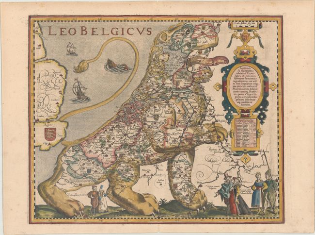
Auction 179, Lot 52
Subject: Cartographic Miscellany, Low Countries
Keere, Pieter Van Den
Leo Belgicus, 1617
Size: 17.9 x 14.6 inches (45.5 x 37.1 cm)
Estimate: $15,000 - $18,000
Most Popular of the "Lions of Belgium"
Sold for: $10,000
Closed on 9/16/2020
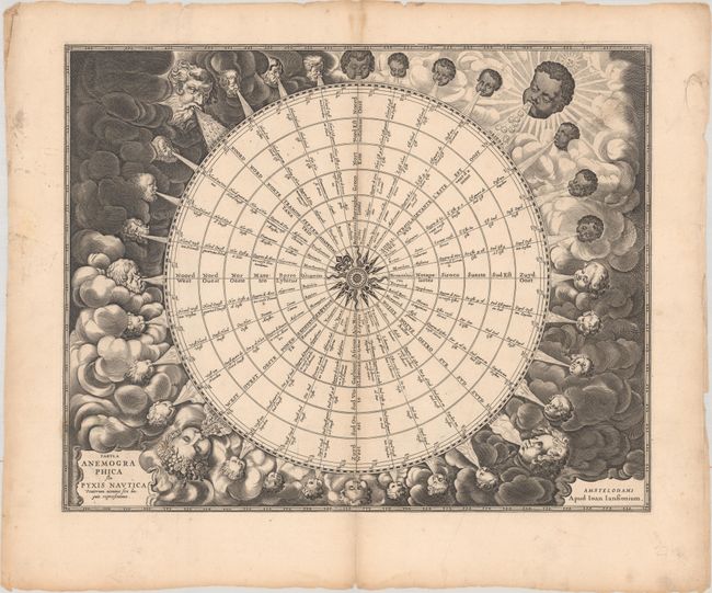
Auction 179, Lot 58
Subject: Cartographic Miscellany, Wind Rose
Jansson, Jan
Tabula Anemographica seu Pyxis Nautica Ventorum Nomina Sex Linguis Repraesentans, 1680
Size: 21.5 x 17.1 inches (54.6 x 43.4 cm)
Estimate: $1,400 - $1,700
Dramatic 32-Point Wind Rose
Sold for: $700
Closed on 9/16/2020
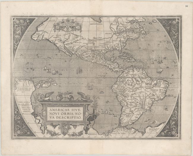
Auction 179, Lot 67
Subject: Western Hemisphere - America
Ortelius, Abraham
Americae sive Novi Orbis, Nova Descriptio, 1587
Size: 18.9 x 13.8 inches (48 x 35.1 cm)
Estimate: $4,000 - $5,000
Ortelius' Influential Map of the New World
Sold for: $3,000
Closed on 9/16/2020
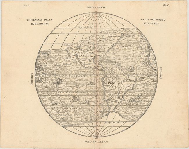
Auction 179, Lot 68
Subject: Western Hemisphere - America
Gastaldi/Ramusio
Universale della Parte del Mondo Nuovamente Ritrovata, 1606
Size: 10.4 x 10.5 inches (26.4 x 26.7 cm)
Estimate: $3,000 - $3,750
First Printed Map to Reflect Coronado's Explorations in the Southwest
Unsold
Closed on 9/16/2020
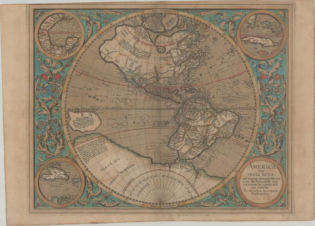
Auction 179, Lot 69
Subject: Western Hemisphere - America
Mercator, Michael
America sive India Nova, ad Magnae Gerardi Mercatoris aui Universalis Imitationem in Compendium Redacta, 1606
Size: 18.1 x 14.4 inches (46 x 36.6 cm)
Estimate: $2,400 - $3,000
Mercator's Foundation Map for the Americas - in Full Contemporary Color
Sold for: $1,800
Closed on 9/16/2020
Auction 179, Lot 71
Subject: Western Hemisphere - America
Blaeu, Willem
Americae Nova Tabula, 1660
Size: 21.4 x 16 inches (54.4 x 40.6 cm)
Estimate: $4,750 - $6,000
Rare Example of Blaeu's Stunning Carte-a-Figures Map of the Americas with Blank Verso
Sold for: $3,500
Closed on 9/16/2020
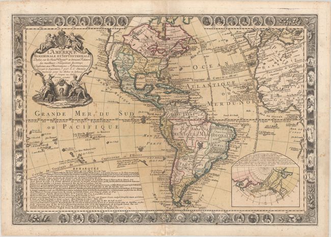
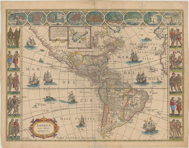
Auction 179, Lot 78
Subject: Western Hemisphere - America
Desnos, Louis Charles
L'Amerique Meridionale et Septentrionale Dressee sur les Nouvles Decouvtes et Dernieres Relations des Meilleurs Navigateurs..., 1760
Size: 27.3 x 18.9 inches (69.3 x 48 cm)
Estimate: $1,400 - $1,700
Highly Decorative Map of the Americas with Large Sea of the West
Sold for: $1,300
Closed on 9/16/2020
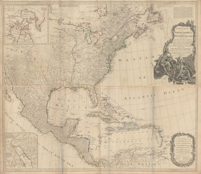
Auction 179, Lot 93
Subject: North America
Laurie & Whittle
[On 4 Sheets] A New Map of North America; with the West India Islands. Divided According to the Preliminary Articles of Peace, Signed at Versailles, 20, Jan. 1783..., 1794
Size: 45.6 x 19.9 inches (115.8 x 50.5 cm)
Estimate: $2,200 - $2,500
Important Large Map of North America Featuring the Young United States
Sold for: $1,600
Closed on 9/16/2020
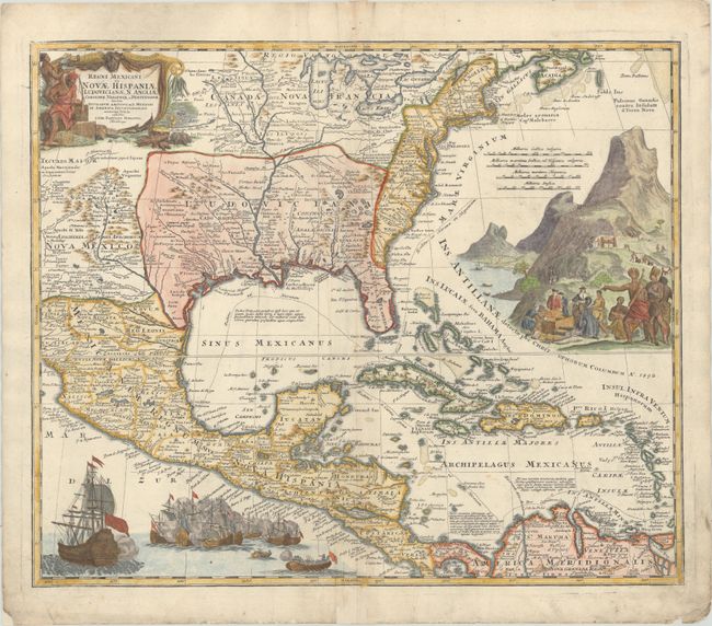
Auction 179, Lot 108
Subject: Colonial Eastern North America & West Indies
Homann, Johann Baptist
Regni Mexicani seu Novae Hispaniae Ludovicianae, N. Angliae, Carolinae, Virginiae et Pensylvaniae nec non Insularum Archipelagi Mexicani in America Septentrionali Accurata Tabula, 1720
Size: 22.3 x 18.7 inches (56.6 x 47.5 cm)
Estimate: $1,400 - $1,700
Homann's Decorative Map of Colonial America in the Era of the War of the Spanish Succession
Sold for: $1,700
Closed on 9/16/2020
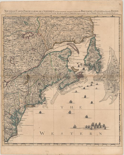
Auction 179, Lot 129
Subject: Colonial Northeastern United States & Canada
Popple/Covens & Mortier
Nouvelle Carte Particuliere de l'Amerique ou sont Exactement Marquees la Nouvelle Bretagne, le Canada ou Nouvelle France, la Nouvelle Ecosse, la Nouvelle Angleterre, la Nouvelle York, la Pensilvanie..., 1741
Size: 20.6 x 22.5 inches (52.3 x 57.2 cm)
Estimate: $2,000 - $2,300
Northeastern Sheet of the Reduced-Size Edition of Popple's Map
Sold for: $1,500
Closed on 9/16/2020
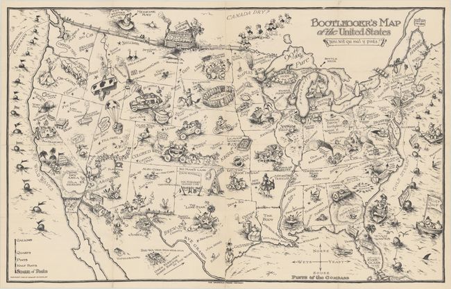
Auction 179, Lot 146
Subject: United States
Bootlegger's Map of the United States, 1926
Size: 33.8 x 21.3 inches (85.9 x 54.1 cm)
Estimate: $1,400 - $1,700
McCandlish's Humorous Prohibition Map
Sold for: $1,000
Closed on 9/16/2020
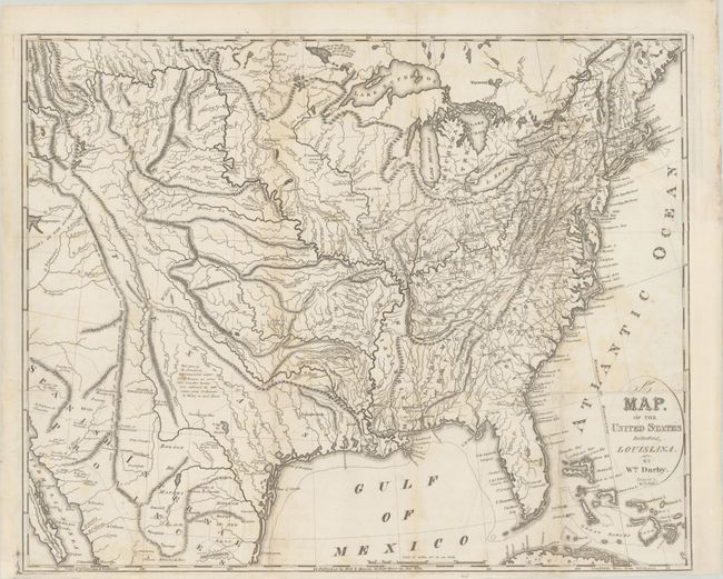
Auction 179, Lot 162
Subject: Eastern United States
Darby, William
A Map of the United States Including Louisiana, 1817
Size: 22.5 x 18.2 inches (57.2 x 46.2 cm)
Estimate: $2,000 - $2,300
Unrecorded State Prior to the Addition of Louisiana
Sold for: $1,200
Closed on 9/16/2020
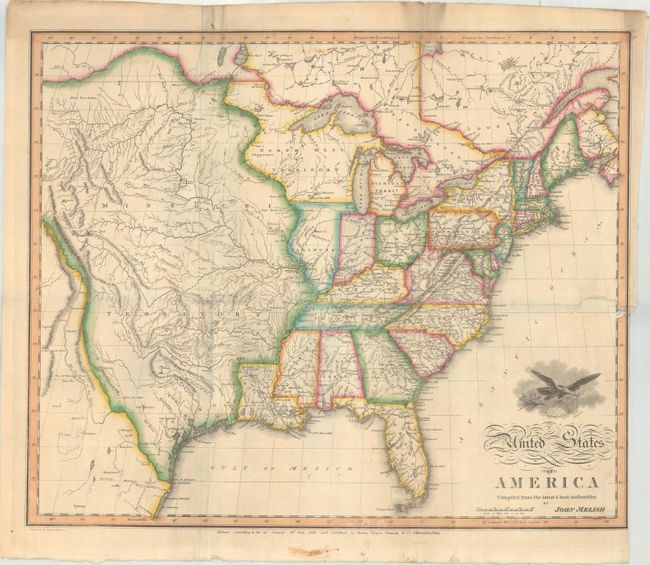
Auction 179, Lot 164
Subject: Eastern United States
Melish, John
United States of America Compiled from the Latest & Best Authorities, 1818
Size: 19.5 x 16.1 inches (49.5 x 40.9 cm)
Estimate: $1,800 - $2,300
Early & Separately Issued Version of Melish's Important Map
Sold for: $3,000
Closed on 9/16/2020
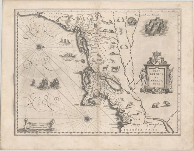
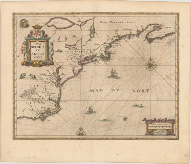
Auction 179, Lot 171
Subject: Colonial New England & Mid-Atlantic United States
Blaeu, Willem
Nova Belgica et Anglia Nova, 1634
Size: 19.9 x 15.3 inches (50.5 x 38.9 cm)
Estimate: $2,000 - $2,300
Important Map of Colonial New England and the Mid-Atlantic - First Edition
Sold for: $1,100
Closed on 9/16/2020
Auction 179, Lot 172
Subject: Colonial New England & Mid-Atlantic United States
Jansson, Jan
Nova Belgica et Anglia Nova, 1646
Size: 19.9 x 15.3 inches (50.5 x 38.9 cm)
Estimate: $1,600 - $1,900
Jansson's Influential Map of the East Coast - in Contemporary Color
Sold for: $1,000
Closed on 9/16/2020
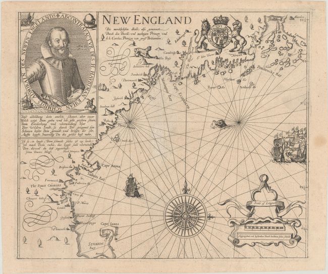
Auction 179, Lot 174
Subject: Colonial New England United States
Smith, John (Capt.)
New England die Mercklichsten Dheile..., 1617
Size: 13.6 x 11.5 inches (34.5 x 29.2 cm)
Estimate: $8,000 - $9,500
German Edition of Capt. John Smith's Foundation Map of New England
Unsold
Closed on 9/16/2020
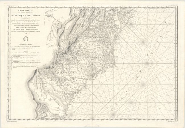
Auction 179, Lot 177
Subject: Colonial Mid-Atlantic & Southeast United States
Sartine
Carte Reduite des Cotes Orientales de l'Amerique Septentrionale Contenant Partie du Nouveau Jersey, la Pen-sylvanie, le Mary-land, la Virginie, la Caroline Septentrionale, la Caroline Meridionale et la Georgie..., 1778
Size: 34.3 x 23.1 inches (87.1 x 58.7 cm)
Estimate: $1,500 - $1,800
Important Revolutionary War-Era Sea Chart of the Colonial Mid-Atlantic and Southeast
Sold for: $1,100
Closed on 9/16/2020
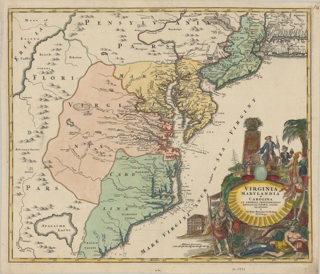
Auction 179, Lot 179
Subject: Colonial Mid-Atlantic United States
Homann, Johann Baptist
Virginia Marylandia et Carolina in America Septentrionali Britannorum Industria Excultae Repraesentatae, 1730
Size: 22.8 x 19.2 inches (57.9 x 48.8 cm)
Estimate: $1,800 - $2,100
Map Created to Promote German Immigration to the New World
Unsold
Closed on 9/16/2020
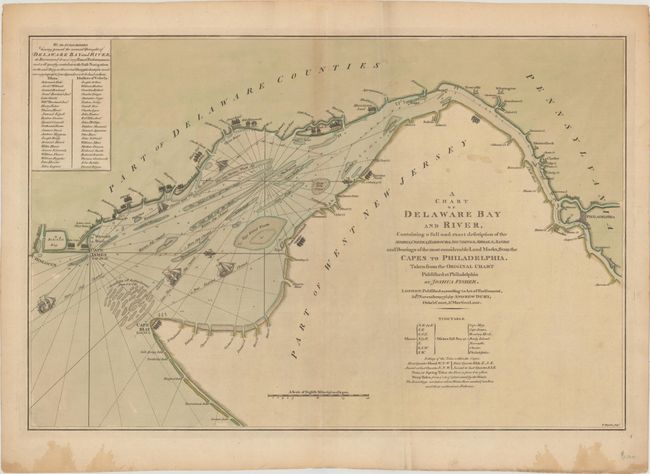
Auction 179, Lot 181
Subject: Colonial Delaware Bay
Dury, Andrew
A Chart of Delaware Bay and River, Containing a Full and Exact Description of the Shores, Creeks, Harbours, Soundings, Shoals, Sands and Bearings of the Most Considerable Land Marks..., 1776
Size: 27.3 x 18 inches (69.3 x 45.7 cm)
Estimate: $2,500 - $3,250
Early Revolutionary War Chart of the Delaware Bay
Sold for: $1,500
Closed on 9/16/2020
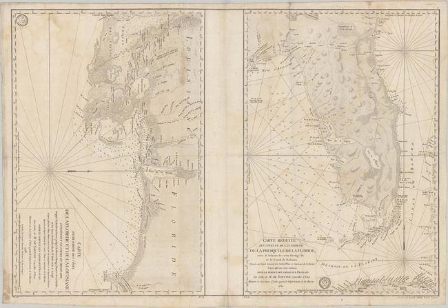
Auction 179, Lot 188
Subject: Colonial Southern United States
Depot de la Marine
Carte d'une Partie des Cotes de la Floride et de la Louisiane... [on sheet with] Carte Reduite des Cotes et de l'Interieur de la Presqu'ile de la Floride, avec le Detroit de Cette Presqu'ile et le Canal de Bahama, 1778-80
Size: 34.3 x 23 inches (87.1 x 58.4 cm)
Estimate: $2,400 - $3,000
Two Important Revolutionary War Charts
Sold for: $1,800
Closed on 9/16/2020
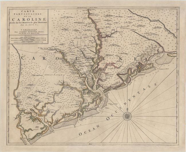
Auction 179, Lot 290
Subject: Colonial South Carolina, Charleston
Sanson/Mortier
Carte Particuliere de la Caroline Dresse sur les Memoires le Plus Nouveaux, 1700
Size: 23.5 x 18.9 inches (59.7 x 48 cm)
Estimate: $3,250 - $4,000
Foundation Map of South Carolina - First State
Sold for: $2,000
Closed on 9/16/2020
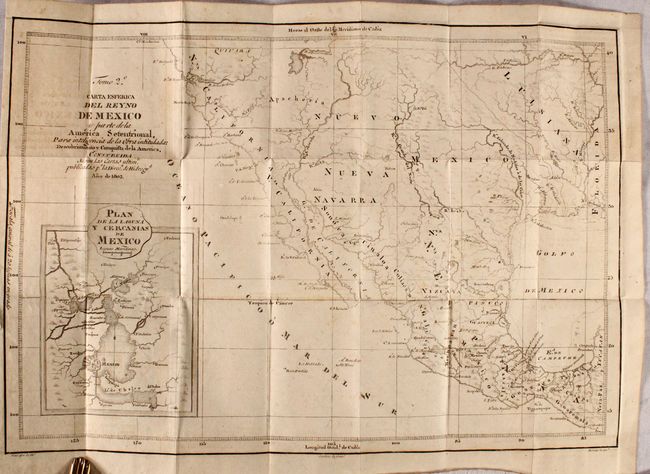
Auction 179, Lot 334
Subject: Southwestern United States & Mexico
Carta Esferica del Reyno de Mexico y Parte de la America Setentrional... [in] Descubrimiento y Conquista de la America, o Compendio de la Historia General del Nuevo Mundo...(Vol 2), 1817
Size: 17.8 x 12.4 inches (45.2 x 31.5 cm)
Estimate: $2,200 - $2,500
A Scarce Spanish Map of the Southwest
Sold for: $1,200
Closed on 9/16/2020
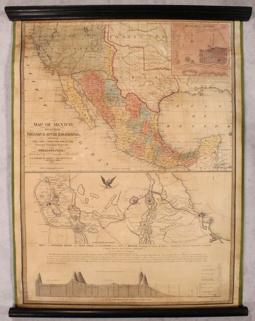
Auction 179, Lot 336
Subject: Southwestern United States & Mexico
Mitchell, Samuel Augustus
Map of Mexico, Including Yucatan & Upper California, Exhibiting the Chief Cities and Towns, the Principal Travelling Routes &c., 1847
Size: 23.6 x 32 inches (59.9 x 81.3 cm)
Estimate: $3,500 - $4,250
Mitchell's Mexican-American War Map
Sold for: $2,500
Closed on 9/16/2020
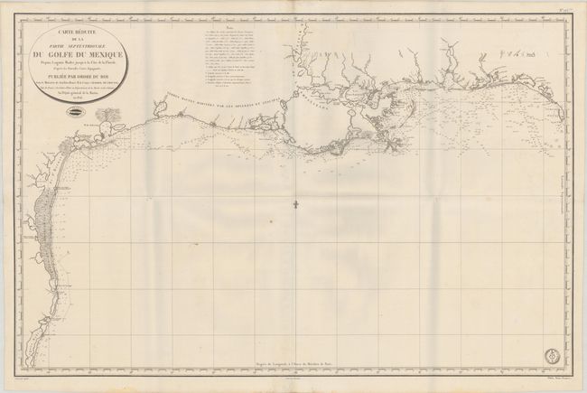
Auction 179, Lot 373
Subject: Gulf of Mexico
Depot de la Marine
[Lot of 2] Carte Reduite de la Partie Septentrionale du Golfe du Mexique Depuis Laguna Madre Jusqu'a la Cote de la Floride... [and] Carte Reduite de la Partie Meridionale du Golfe du Mexique Depuis le Cap Catoche Jusqu'a Laguna Madre..., 1826
Size: 35.2 x 22.8 inches (89.4 x 57.9 cm)
Estimate: $2,000 - $2,500
Rare Two-Sheet Map of Gulf of Mexico Based on Spanish Sources
Sold for: $1,000
Closed on 9/16/2020
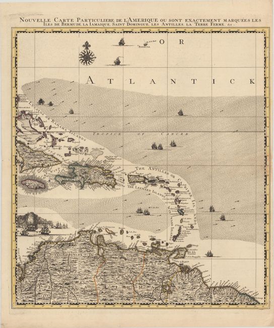
Auction 179, Lot 374
Subject: Caribbean & Northern South America
Popple/Covens & Mortier
Nouvelle Carte Particuliere de l'Amerique ou sont Exactement Marquees les Iles de Bermude la Iamaique, Saint Domingue, les Antilles, la Terre Ferme, &c., 1741
Size: 20.7 x 22.5 inches (52.6 x 57.2 cm)
Estimate: $1,400 - $1,700
Southeastern Sheet of the Reduced-Size Edition of Popple's Map
Sold for: $1,200
Closed on 9/16/2020
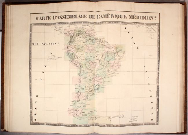
Auction 179, Lot 409
Subject: South America, Atlases
Vandermaelen, Philippe Marie Guillaume
Atlas Universel de Geographie Physique, Politique, Statistique et Mineralogique ... Cinquieme Partie. - Amer. Merid., 1827
Size: 15 x 21.6 inches (38.1 x 54.9 cm)
Estimate: $5,000 - $6,500
Vandermaelen's Remarkable Atlas of South America
Sold for: $2,500
Closed on 9/16/2020
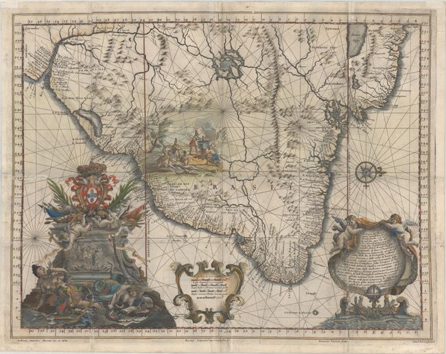
Auction 179, Lot 420
Subject: Brazil
Santa Teresa, J. J. de
Il Regno del Brasile Parte Nobilissima del Mondo Nuovo..., 1698
Size: 22.8 x 17.7 inches (57.9 x 45 cm)
Estimate: $1,600 - $2,000
A Rare Map of Brazil from the Santa Teresa
Unsold
Closed on 9/16/2020
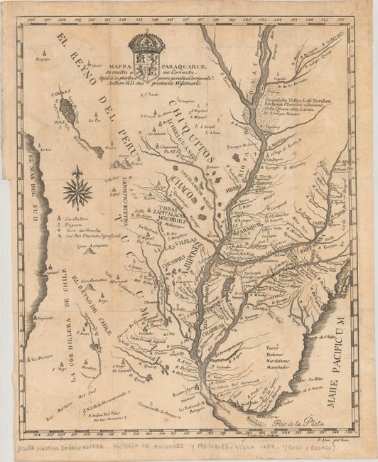
Auction 179, Lot 425
Subject: Central South America
Mappa Paraquariae in Multis a me Correcta..., 1784
Size: 13.7 x 16.9 inches (34.8 x 42.9 cm)
Estimate: $1,200 - $1,500
Rare Jesuit Map Published after Suppression of Society of Jesus
Sold for: $900
Closed on 9/16/2020
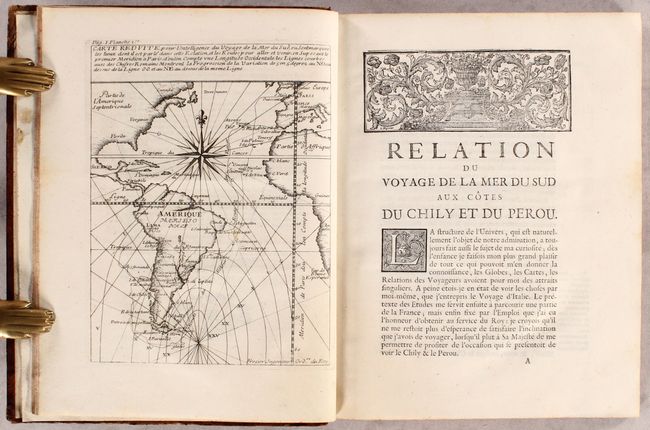
Auction 179, Lot 435
Subject: Western South America
Frezier, Amedee Francois
Relation du Voyage de la Mer du Sud aux Cotes du Chily et du Perou..., 1716
Size: 7.7 x 9.9 inches (19.6 x 25.1 cm)
Estimate: $2,750 - $3,500
First Edition of Frezier's Work on South America with 24 Maps
Unsold
Closed on 9/16/2020
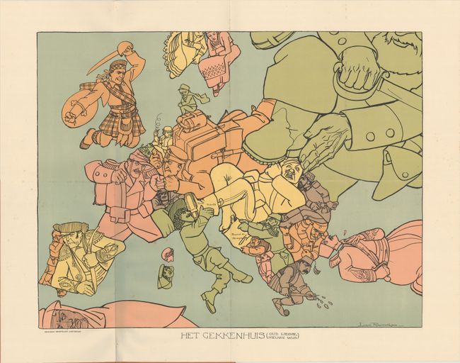
Auction 179, Lot 458
Subject: Europe, World War I
Het Gekkenhuis (Oud Liedje, Nieuwe Wijs), 1914
Size: 20.4 x 15.8 inches (51.8 x 40.1 cm)
Estimate: $1,100 - $1,400
Rare Dutch Satirical Map of World War I
Sold for: $550
Closed on 9/16/2020
Auction 179, Lot 464
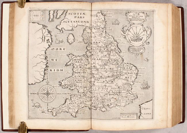
Subject: Britain, Atlas
Camden, William
Britain, or a Chorographicall Description of the Most Flourishing Kingdomes, England, Scotland, and Ireland..., 1610
Size: 9 x 13.3 inches (22.9 x 33.8 cm)
Estimate: $5,000 - $6,500
1610 Edition of Camden's Britannia with 57 Maps by Kip and Hole
Sold for: $3,750
Closed on 9/16/2020
Auction 179, Lot 478
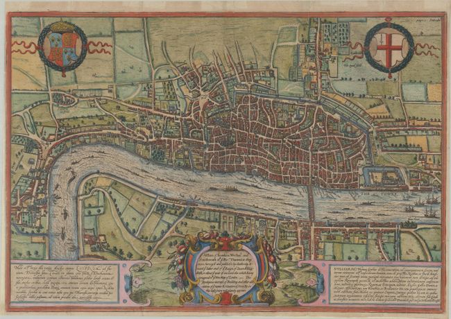
Subject: London, England
Braun & Hogenberg
A Plan of London Westmr. and Southwark wth ye Rivr Thames as They Were Survey'd and Publish't by Authority..., 1708
Size: 19.1 x 13.1 inches (48.5 x 33.3 cm)
Estimate: $2,750 - $3,500
Fourth State of Braun & Hogenberg's Plan of London
Unsold
Closed on 9/16/2020
Auction 179, Lot 483
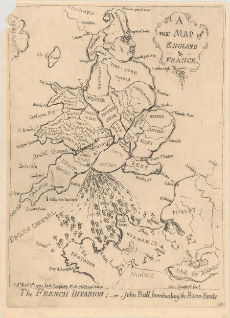
Subject: England, Wales, & France
A New Map of England & France / The French Invasion; - or - John Bull, Bombarding the Bum-Boats, 1851
Size: 9.8 x 12.9 inches (24.9 x 32.8 cm)
Estimate: $800 - $950
Caricature Map Spoofing British/French Relations
Sold for: $450
Closed on 9/16/2020
Auction 179, Lot 600
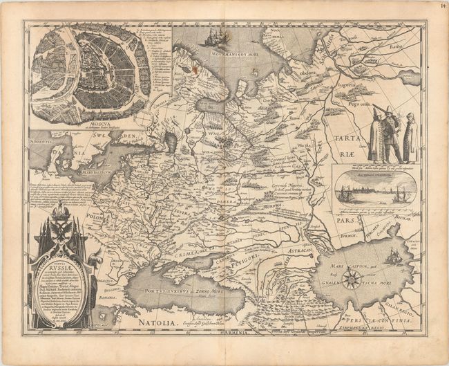
Subject: Russia in Europe
Blaeu, Willem
Tabula Russiae ex Autographo, quod Delineandum Curavit Foedor Filius Tzaris Boris Desumpta ... M.DC.XIIII, 1634
Size: 21.6 x 16.8 inches (54.9 x 42.7 cm)
Estimate: $2,000 - $2,300
Blaeu's Decorative Map of Russia
Unsold
Closed on 9/16/2020
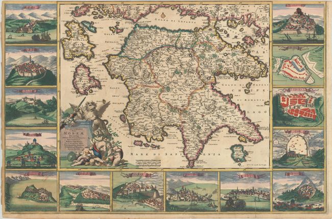
Auction 179, Lot 621
Subject: Southern Greece
Wit, Frederick de
Peloponnesus Hodie Moreae Regnum, Distincte Divisum, in Omnes suas Provincias..., 1690
Size: 29.9 x 19.7 inches (75.9 x 50 cm)
Estimate: $2,500 - $3,250
A Spectacular Map of Peloponessos
Sold for: $1,800
Closed on 9/16/2020
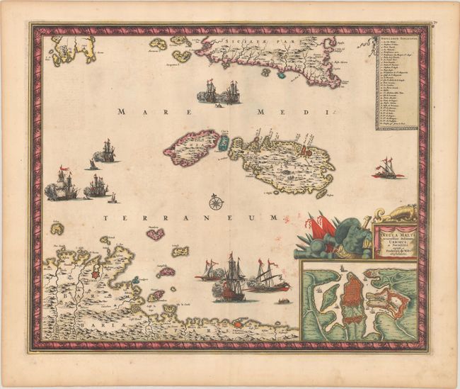
Auction 179, Lot 654
Subject: Malta
Wit, Frederick de
Insula Malta Accuratissime Delineata, Urbibus, et Fortalitiis, 1680
Size: 21.1 x 17.4 inches (53.6 x 44.2 cm)
Estimate: $1,200 - $1,500
One of the Most Decorative 18th Century Maps of Malta
Unsold
Closed on 9/16/2020
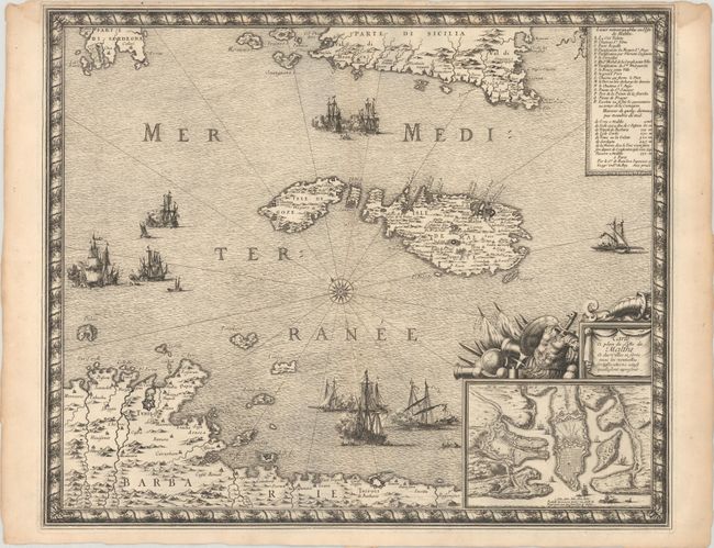
Auction 179, Lot 655
Subject: Malta
Beaulieu, Sebastian de Pontault
Carte et Plan de l'Isle de Malthe et des Villes et Forts avec les Nouvelles Fortiffications Ainsy quelle sont Apresent, 1680
Size: 21.2 x 17.5 inches (53.8 x 44.5 cm)
Estimate: $1,400 - $1,700
Rare and Decorative Map of Malta
Sold for: $700
Closed on 9/16/2020
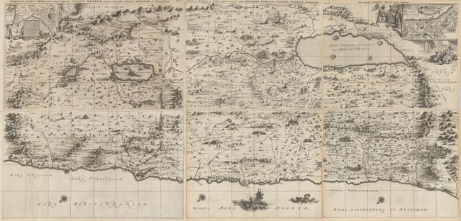
Auction 179, Lot 691
Subject: Holy Land
Dapper, Olivier
[On 6 sheets] Dimida Tribus Manasse ... [and] Tribus Ruben, et Gad ... [and] Pars Maxima Tribus Iuda ... [and] Tribus Aser ... [and] Tribuum Ephraim ... [and] Tribus Simeon …, 1677
Size: See Description
Estimate: $1,400 - $1,700
Impressive 6-Sheet Wall Map of the Holy Land
Unsold
Closed on 9/16/2020
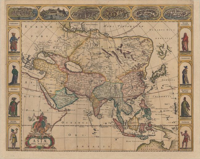
Auction 179, Lot 725
Subject: Asia
Wit, Frederick de
Asiae Nova Descriptio, 1660
Size: 22.1 x 17.4 inches (56.1 x 44.2 cm)
Estimate: $2,000 - $2,400
De Wit's Carte-a-Figures Map of Asia
Sold for: $1,200
Closed on 9/16/2020
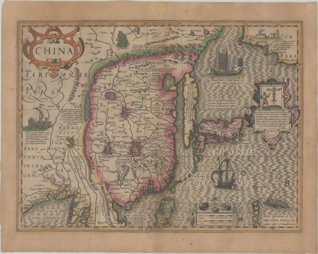
Auction 179, Lot 739
Subject: China, Korea & Japan
Mercator/Hondius
China, 1613
Size: 18.1 x 13.4 inches (46 x 34 cm)
Estimate: $1,900 - $2,200
Hondius' Map of China, Korea, and Japan in Full Contemporary Color
Sold for: $1,600
Closed on 9/16/2020
62 lots
Page 1 of 2