Subject: Gulf of Mexico
Period: 1826 (dated)
Publication:
Color: Black & White
Size:
35.2 x 22.8 inches
89.4 x 57.9 cm
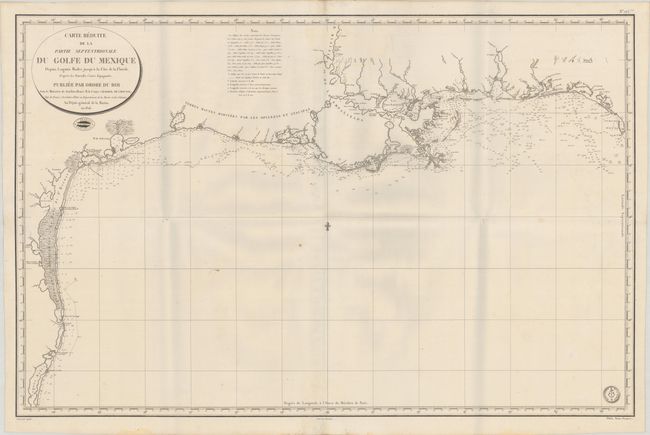
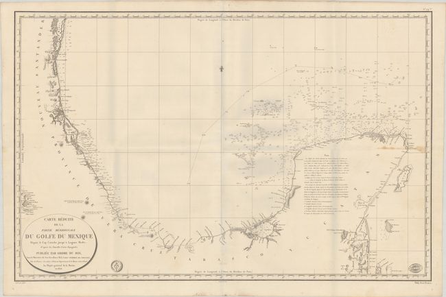
This is a rare, two-sheet edition of the Depot de la Marine's chart of the Gulf of Mexico based on the Direccion de Hidrografia's important charts of the region. In 1783, Jose Antonio de Evia was commissioned by the interim governor of Spanish Louisiana, Bernardo de Gálvez, to explore the Gulf Coast from West Florida to Tampico. The exploration was conducted by Evia in 1785-86 and included the coasts of Florida, Alabama, Mississippi, Louisiana, Texas and Mexico. Evia's survey is considered the best work on the Gulf Coast of the 18th century and served as the source material for numerous charts issued by the Direccion de Hidrografia, including the 1799 Carta Esferica que Comprehende las Costas del Seno Mexicano and the more detailed 1807 Carta Particular de las Costas Septentrionales del Seno Mexicano. The northern sheet in this lot is based on the latter map, and includes a southern sheet that extends the coastline from St. Joseph Bay, Florida to the Yucatan Peninsula. One of the key features is the depiction of six of the seven important rivers in Texas, with the Brazos River oddly missing. The map depicts the lower courses of the Sabine, Trinity, Colorado, Guadalupe (San Marcos), Nueces, and Rio Grande (R. Bravo du N.). The charts are filled with soundings and navigational information. Notes on each sheet sheet explain that the soundings are given in French fathoms, and include a lettered guide to the composition of the Gulf floor as indicated on the map. This French edition retains most of the Spanish nomenclature. Engraved by Caplin with lettering by Besancon. Each sheet includes the engraved seal of the Depot de la Marine and the price ("Prix Trois Francs"). The northern sheet also has the blind stamp of geographer Dezauche
It is very rare to find both sheets together and in good condition.
References:
Condition: B+
Crisp impressions on bright sheets, with the southern sheet on paper with a "Depot de la Marine" watermark, now folded with very minor soiling. The northern sheet has a couple of short separations along the folds, and the southern sheet has a damp stain along the horizontal fold at far right. Both sheets include the stamp of J. Trabaud in Marseille. There are grayish shadows along the folds that are caused by our scanner and do not appear on the maps themselves. The first image is a composite image - the map is in two separate sheets.