Subject: World
Period: 1786 (dated)
Publication: Nouvel Atlas Historique et Geographique...
Color: Hand Color
Size:
30.1 x 20.8 inches
76.5 x 52.8 cm
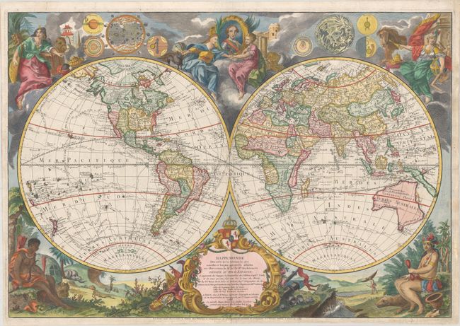
This scarce map is filled with both geographical information and decorative elements, and carries forward the myth of a Northwest Passage. First published in 1761, the map is known in at least 7 states, with notable differences to the cartography of northwest North America. All states include the mythical M. de l'Ouest, Lac Velasco, and Lac de Fonte, the latter of which is nearly connected to Hudson Bay by the Detroit de Ronquillo. However the passage between the Mer de l'Ouest and other lakes and rivers differs in various states. In this example, which McGuirk notes as the 5th state, the Mer de l'Ouest connects to Lac de Fonte, a change from earlier states in which it connects to the Hudson Bay. L. Bourbon (likely Lake Winnipeg) has been added in between the Mer de l'Ouest and Hudson Bay. A river flowing southwest from L. Bourbon nearly connects to the R. Bravo (Rio Grande), which itself extends way too far north. Only a few cities are noted, including Santa Fe, which is placed approximately in present-day Wyoming. Also of interest in the northwest is the depiction of Alaska, which features oversized inlets. Numerous Native Indian tribes are noted throughout North America. True to French ambitions, the British are shown occupying the eastern seaboard while France controls Canada, Louisiana, and Florida. The new United States is erroneously missing, despite the map being dated 1789.
Also of note are the routes of various explorers traced throughout the oceans, which were added in the fourth state, including Captain Cook, Charles Clarke and John Gore, and Captain Furneaux. Australia and New Guinea are updated from previous states based on Cook's voyages, with New Guinea shown separate from Australia, and Australia fully outlined (albeit rudimentary) and connected to Tasmania.
Surrounding the hemispheres are elaborate vignettes in each corner featuring female figures representing the four continents. At top center is a portrait of Charles III, who is flanked by Copernicus' model of the solar system and depictions of the sun, moon, and planets based on the work of Cassini and Kircher.
This decorative map serves as an excellent summary near the conclusion of the age of discovery.
References: McGuirk #134, state 5.
Condition: A
A crisp impression on a bright sheet with the watermark of a Masonic cross encircled in rosary beads. There is marginal soiling and professional repairs to several short tears along the edges of the sheet.