Showing Featured Lots(remove filter)
Showing results for:Auction 175
Catalog Archive
54 lots
Page 1 of 2
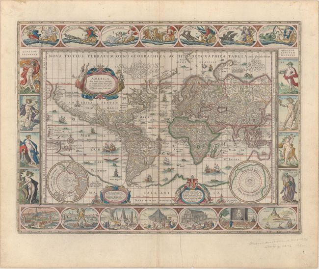
Auction 175, Lot 2
Subject: World
Blaeu, Willem
Nova Totius Terrarum Orbis Geographica ac Hydrographica Tabula, 1643
Size: 21.4 x 16 inches (54.4 x 40.6 cm)
Estimate: $12,000 - $15,000
Blaeu's Magnificent Carte-a-Figures World Map
Sold for: $8,500
Closed on 11/13/2019
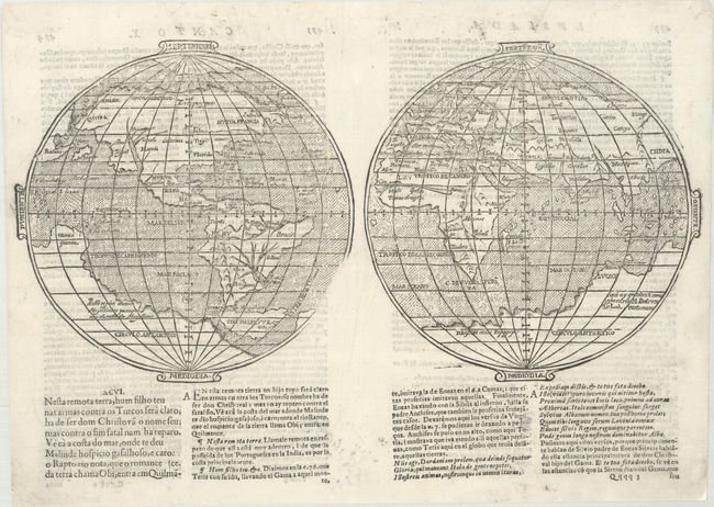
Auction 175, Lot 3
Subject: World
Camoens, Luis de
[Untitled - World], 1639
Size: 15.6 x 7.8 inches (39.6 x 19.8 cm)
Estimate: $4,000 - $5,000
A Scarce Spanish World Map
Sold for: $3,000
Closed on 11/13/2019
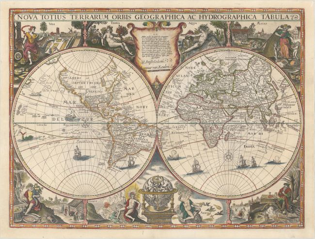
Auction 175, Lot 4
Subject: World
Keulen, Johannes van
Nova Totius Terrarum Orbis Geographica ac Hydrographica Tabula, 1680
Size: 21.6 x 16.2 inches (54.9 x 41.1 cm)
Estimate: $7,500 - $9,000
First Printed World Map to Depict Western Australia
Sold for: $21,000
Closed on 11/13/2019
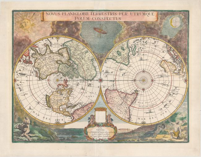
Auction 175, Lot 5
Subject: World
Blaeu/Valck
Novus Planiglobii Terrestris per Utrumque Polum Conspectus, 1695
Size: 21.3 x 16 inches (54.1 x 40.6 cm)
Estimate: $5,500 - $7,000
Superb World Map on a Polar Projection
Sold for: $4,000
Closed on 11/13/2019
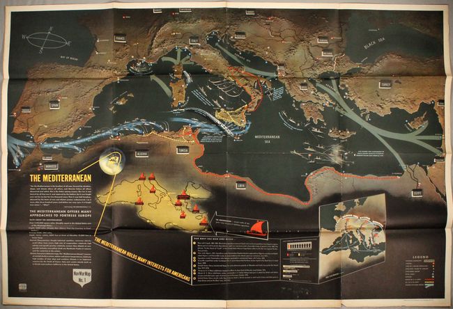
Auction 175, Lot 19
Subject: World, World War II
U.S. Navy Dept.
[Complete Set of 6 Nav War Maps - On 3 Sheets], 1944
Size: 57.2 x 38.1 inches (145.3 x 96.8 cm)
Estimate: $1,500 - $2,000
Complete Set of Nav War Maps
Sold for: $1,100
Closed on 11/13/2019
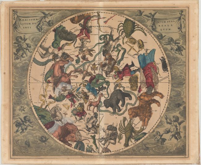
Auction 175, Lot 31
Subject: Celestial
Cellarius/Schenk & Valck
Haemisphaerium Stellatum Boreale Antiquum, 1708
Size: 20.1 x 17 inches (51.1 x 43.2 cm)
Estimate: $2,500 - $3,250
One of the Finest Celestial Charts Ever Produced in Full Contemporary Color
Unsold
Closed on 11/13/2019
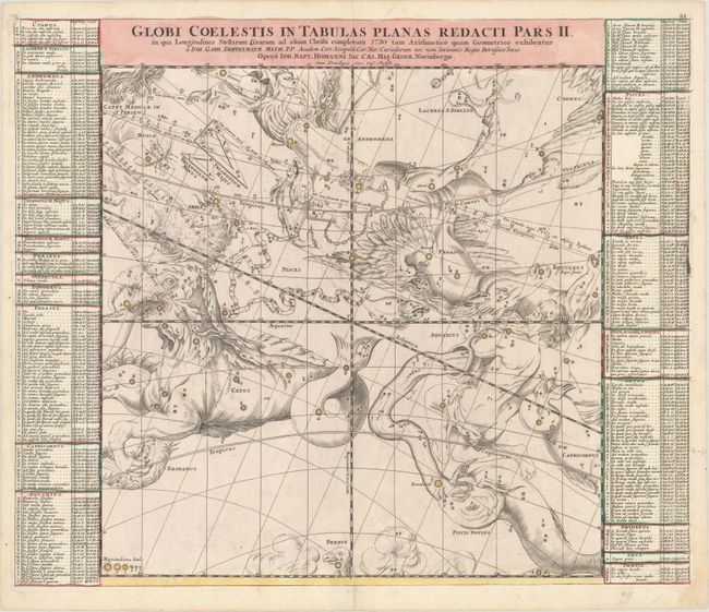
Auction 175, Lot 32
Subject: Celestial
Doppelmayr/Homann
[Lot of 5] Globi Coelestis in Tabulas Planas Redacti Pars II, III, IV, V, VI, 1730
Size: 22.9 x 19.2 inches (58.2 x 48.8 cm)
Estimate: $3,250 - $4,000
Lot of 5 of Doppelmayr's Magnificent Celestial Charts on a Gnomonic Projection
Unsold
Closed on 11/13/2019

Auction 175, Lot 35
Subject: Armillary Sphere
Delamarche, Charles Francois
[Armillary Sphere], 1805
Size: 13 x 18 inches (33 x 45.7 cm)
Estimate: $4,000 - $5,000
Stunning French Armillary Sphere
Sold for: $6,000
Closed on 11/13/2019
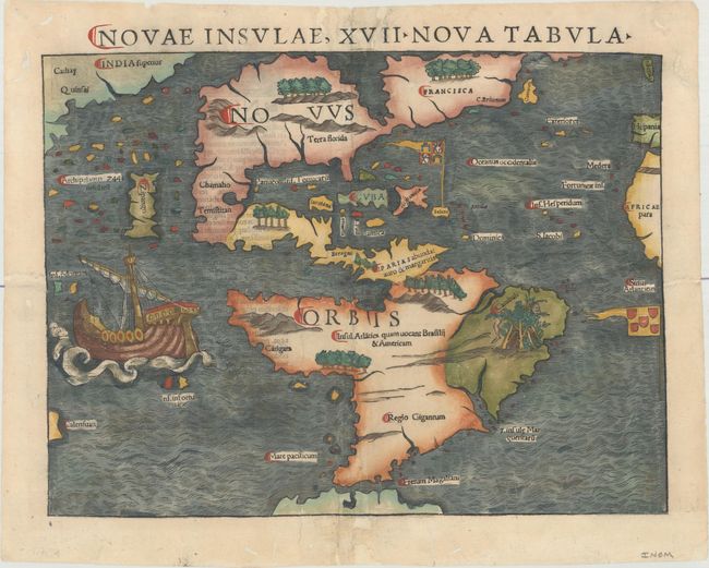
Auction 175, Lot 45
Subject: Western Hemisphere - America
Munster, Sebastian
Novae Insulae, XVII Nova Tabula, 1540
Size: 13.4 x 10 inches (34 x 25.4 cm)
Estimate: $5,500 - $7,000
First State, First Issue of One of the Most Important 16th Century Maps of the New World
Sold for: $5,500
Closed on 11/13/2019
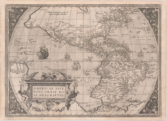
Auction 175, Lot 46
Subject: Western Hemisphere - America
Ortelius, Abraham
Americae sive Novi Orbis Nova Descriptio, 1571
Size: 20 x 14.4 inches (50.8 x 36.6 cm)
Estimate: $5,500 - $6,500
Rare First Plate of Ortelius' Influential Map of the New World
Sold for: $5,500
Closed on 11/13/2019
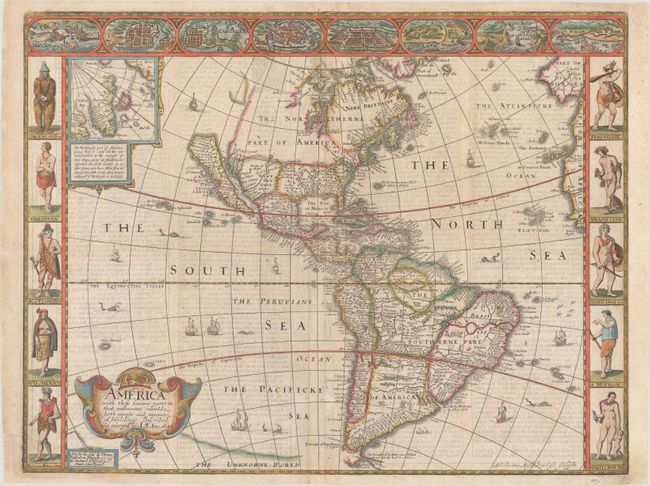
Auction 175, Lot 47
Subject: Western Hemisphere - America
Speed, John
America with Those Known Parts in That Unknowne Worlde Both People and Manner of Buildings Discribed and Inlarged, 1626
Size: 20.3 x 15.6 inches (51.6 x 39.6 cm)
Estimate: $4,750 - $6,000
Speed's Popular Carte-a-Figures Map of the Americas
Sold for: $4,500
Closed on 11/13/2019
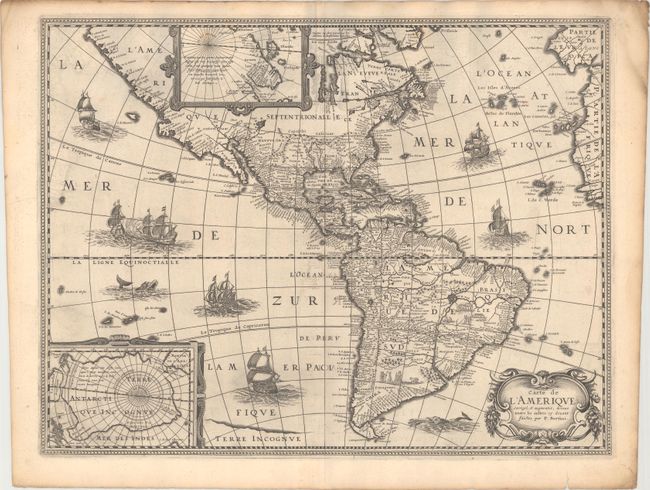
Auction 175, Lot 48
Subject: Western Hemisphere - America
Bertius/Tavernier
Carte de l'Amerique Corrigee, et Augmentee, Dessus Toutes les Aultres cy Devant, 1627
Size: 19.8 x 15 inches (50.3 x 38.1 cm)
Estimate: $1,500 - $1,800
Richly Embellished Map of the Americas
Sold for: $750
Closed on 11/13/2019
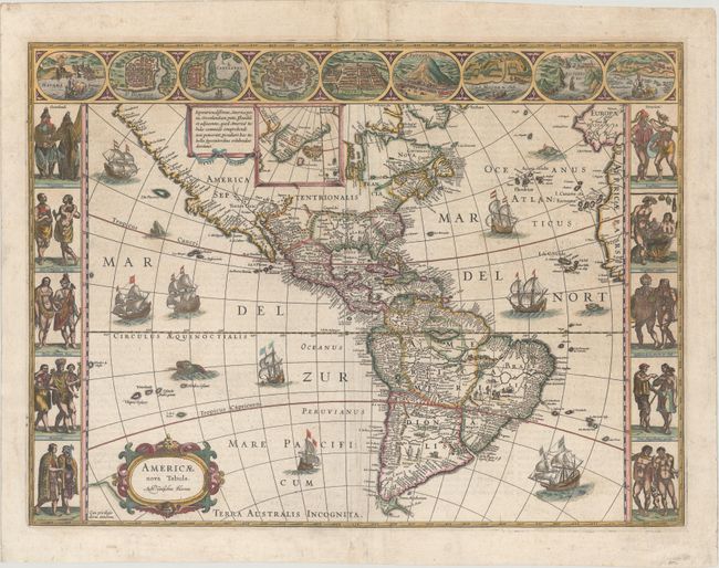
Auction 175, Lot 51
Subject: Western Hemisphere - America
Blaeu, Willem
Americae Nova Tabula, 1638
Size: 21.8 x 16.2 inches (55.4 x 41.1 cm)
Estimate: $6,000 - $7,500
Blaeu's Stunning Carte-a-Figures Map of the Americas
Sold for: $4,250
Closed on 11/13/2019
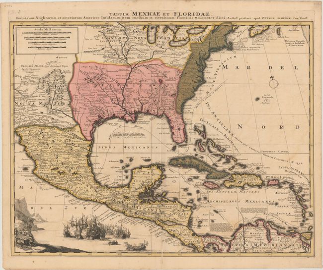
Auction 175, Lot 77
Subject: Colonial Eastern North America & West Indies
Schenk, Pieter
Tabula Mexicae et Floridae, Terrarum Anglicarum, et Anteriorum Americae Insularum; Item Cursuum et Circuituum Fluminis Mississipi..., 1722
Size: 23.9 x 18.5 inches (60.7 x 47 cm)
Estimate: $2,000 - $2,300
Schenk's Derivative of Delisle's Influential 1703 Map
Sold for: $1,500
Closed on 11/13/2019
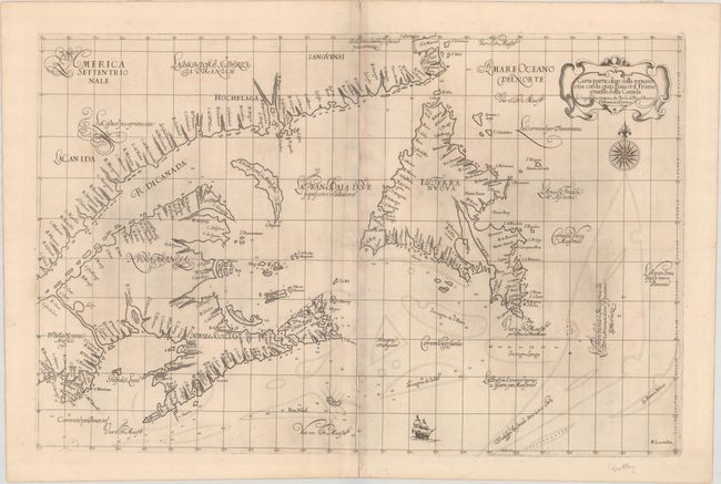
Auction 175, Lot 81
Subject: Eastern Canada
Dudley, Robert (Sir)
Carta Particolare della Terra Nuova con la Gran Baia et il Fiume Grande della Canida ... D'America Car.a Prima, 1647
Size: 29.3 x 19.1 inches (74.4 x 48.5 cm)
Estimate: $3,500 - $4,500
First Printed Sea Chart of the Gulf of St. Lawrence
Sold for: $2,500
Closed on 11/13/2019
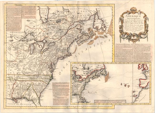
Auction 175, Lot 91
Subject: Colonial Eastern United States & Canada
Anon.
Amerique Septentrionale, Suivant les Nouvelles Decouvertes, Augmente des Collonies qui sont Derriere la Virginie et du Cour de l'Ohio..., 1757
Size: 27.1 x 19.1 inches (68.8 x 48.5 cm)
Estimate: $2,750 - $3,500
A Rare French Map Countering Jefferys' French & Indian War Map
Sold for: $2,500
Closed on 11/13/2019
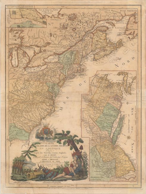
Auction 175, Lot 95
Subject: Colonial Eastern United States & Canada
Denis, Louis
Carte du Theatre de la Guerre Presente en Amerique Dressee d'Apres les Nouvelles Cartes Anglaises, 1782
Size: 19.6 x 26.3 inches (49.8 x 66.8 cm)
Estimate: $3,000 - $3,750
Scarce American Revolutionary War Map
Sold for: $1,800
Closed on 11/13/2019
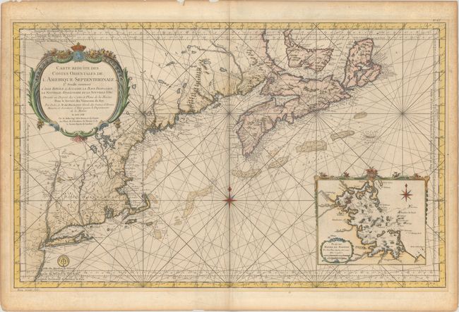
Auction 175, Lot 100
Subject: Colonial Northeastern United States & Canada
Bellin, Jacques Nicolas
Carte Reduite des Costes Orientales de l'Amerique Septentrionale 1re Feuille Contenant l'Isle Royale, l'Accadie, la Baye Francoise, la Nouvelle Angleterre et la Nouvelle Yorc..., 1757
Size: 34.9 x 21.5 inches (88.6 x 54.6 cm)
Estimate: $1,900 - $2,200
Scarce Large-Scale Chart of the Coast of New England
Unsold
Closed on 11/13/2019
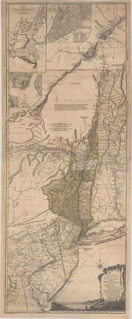
Auction 175, Lot 101
Subject: Colonial Northeast United States & Quebec
Holland/Pownal
The Provinces of New York, and New Jersey; with Part of Pensilvania, and the Province of Quebec..., 1777
Size: 20.3 x 52 inches (51.6 x 132.1 cm)
Estimate: $3,500 - $4,500
Rare German Edition of an Important Revolutionary War Period Map
Sold for: $2,300
Closed on 11/13/2019
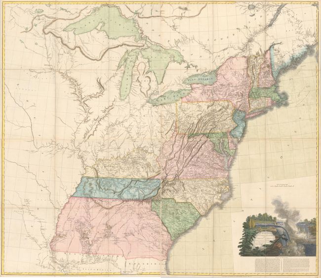
Auction 175, Lot 115
Subject: Eastern United States
Arrowsmith, Aaron, Sr.
[On 4 Sheets] A Map of the United States of North America Drawn from a Number of Critical Researches, 1802
Size: 27.8 x 24.3 inches (70.6 x 61.7 cm)
Estimate: $8,000 - $10,000
Arrowsmith's Large-Format Map Used by Lewis & Clark
Sold for: $5,500
Closed on 11/13/2019
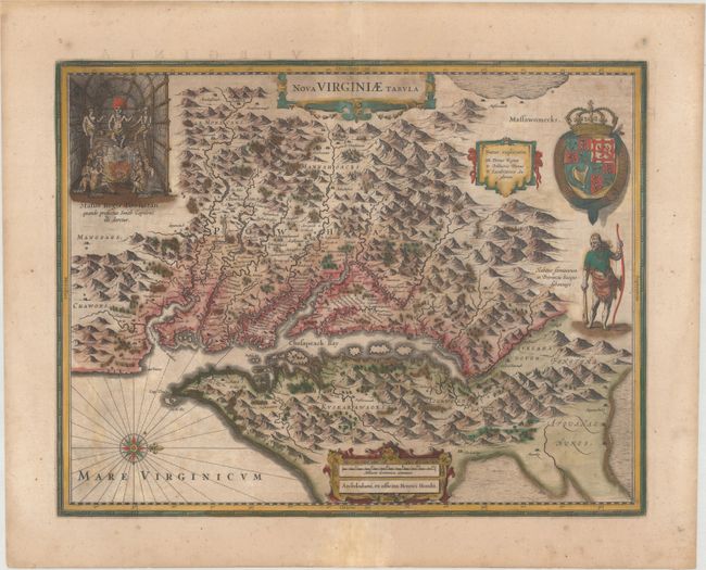
Auction 175, Lot 126
Subject: Colonial Mid-Atlantic United States
Hondius, Henricus
Nova Virginiae Tabula, 1647
Size: 19.4 x 15 inches (49.3 x 38.1 cm)
Estimate: $1,400 - $1,700
One of the Most Important 17th Century Maps of the Chesapeake Bay in Full Contemporary Color
Sold for: $900
Closed on 11/13/2019
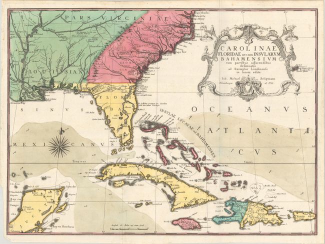
Auction 175, Lot 134
Subject: Colonial Southeast United States, Bahamas & Greater Antilles
Seligmann, Johann Michael
Carolinae Floridae nec non Insularum Bahamensium cum Partibus Adjacendibus Delineatio ad Exemplar Londinense in Lucem Edita, 1755
Size: 23.1 x 16.8 inches (58.7 x 42.7 cm)
Estimate: $4,000 - $5,000
German Edition of Catesby's Scarce and Important Map of the Southeastern United States
Sold for: $2,600
Closed on 11/13/2019
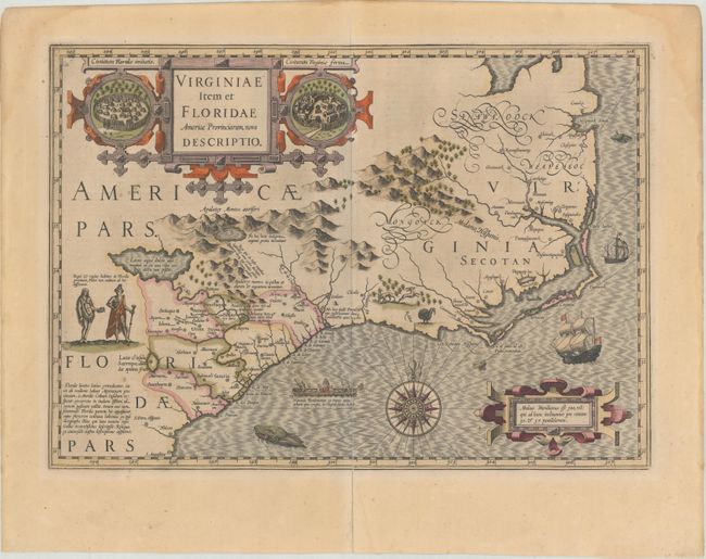
Auction 175, Lot 135
Subject: Colonial Southeast United States
Hondius, Jodocus
Virginiae Item et Floridae Americae Provinciarum, Nova Descriptio, 1623
Size: 19 x 13.4 inches (48.3 x 34 cm)
Estimate: $1,700 - $2,000
A Seminal Map of the Southeast and Early American Cartography
Sold for: $1,200
Closed on 11/13/2019
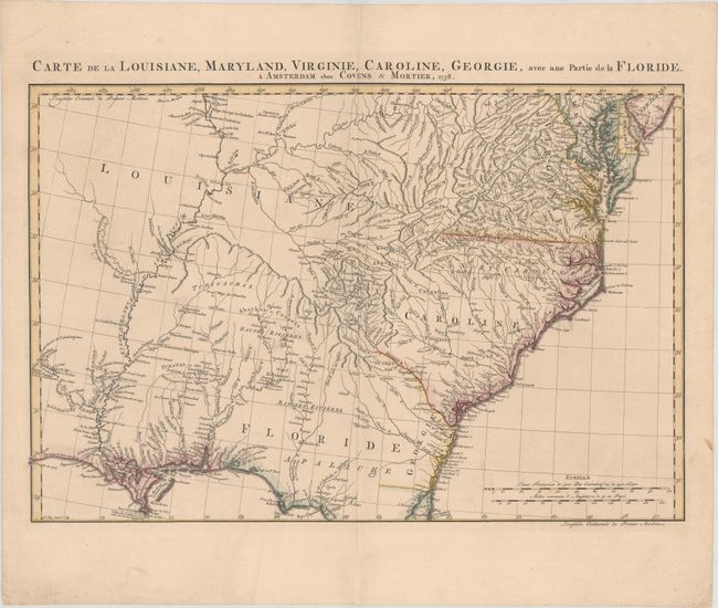
Auction 175, Lot 139
Subject: Colonial Southeast United States
Covens & Mortier
Carte de la Louisiane, Maryland, Virginie, Caroline, Georgie, avec une Partie de la Floride, 1758
Size: 23.1 x 15.4 inches (58.7 x 39.1 cm)
Estimate: $1,200 - $1,500
Covens & Mortier's Map of the Southeast Issued During the French and Indian War
Unsold
Closed on 11/13/2019
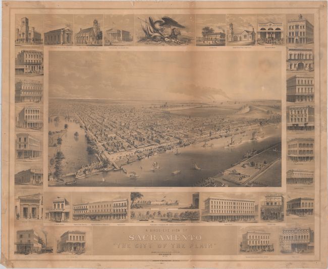
Auction 175, Lot 173
Subject: Sacramento, California
Britton & Rey
A Birds-Eye of Sacramento "The City of the Plain", 1857
Size: 35 x 28.5 inches (88.9 x 72.4 cm)
Estimate: $1,400 - $2,000
Rare View of Sacramento Just After Gold Rush
Sold for: $1,300
Closed on 11/13/2019
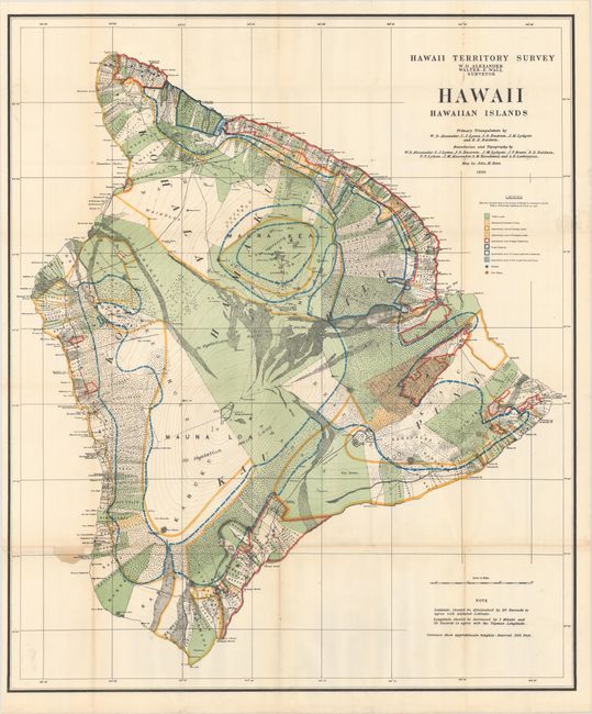
Auction 175, Lot 195
Subject: Hawaii
Hawaii Territorial Surveys
[Lot of 9 - Hawaii Territorial Surveys Maps], 1897-1906
Size: See Description
Estimate: $1,200 - $1,500
Complete Set of Hawaii Territory Maps
Sold for: $1,600
Closed on 11/13/2019
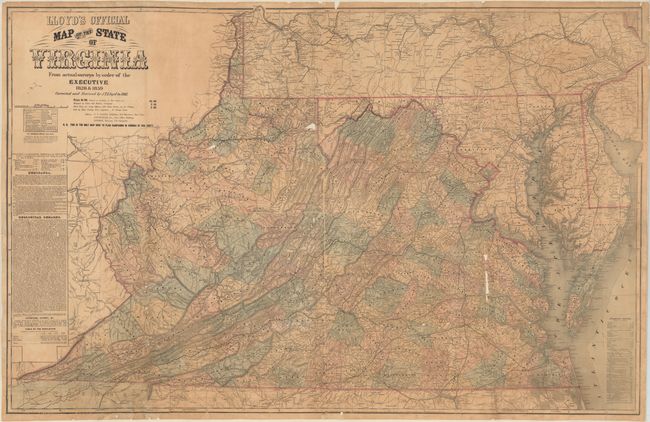
Auction 175, Lot 250
Subject: Virginia & West Virginia, Civil War
Lloyd, James T.
Lloyd's Official Map of the State of Virginia from Original Surveys by Order of the Executive 1828 & 1859..., 1861
Size: 47.3 x 30.3 inches (120.1 x 77 cm)
Estimate: $3,500 - $4,250
First Edition of Lloyd's Civil War Map of Virginia
Unsold
Closed on 11/13/2019

Auction 175, Lot 274
Subject: Roatan, Honduras
Toms, William Henry
A Draught of the Island Rattan, in the Bay of Honduras..., 1744
Size: 27.3 x 19.6 inches (69.3 x 49.8 cm)
Estimate: $2,000 - $3,000
The First Map of Roatan in Full Contemporary Color
Sold for: $1,200
Closed on 11/13/2019
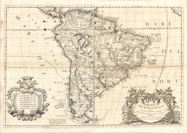
Auction 175, Lot 305
Subject: South America
Coronelli, Vincenzo Maria
[On 2 Sheets] America Meridionale, 1691
Size: 17.8 x 23.8 inches (45.2 x 60.5 cm)
Estimate: $1,600 - $1,900
Coronelli's Influential and Decorative Map of South America
Sold for: $1,000
Closed on 11/13/2019
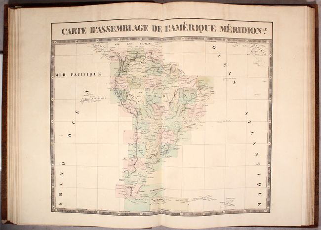
Auction 175, Lot 306
Subject: South America, Atlases
Vandermaelen, Philippe Marie Guillaume
Atlas Universel de Geographie Physique, Politique, Statistique et Mineralogique ... Cinquieme Partie. - Amer. Merid., 1827
Size: 15 x 21.6 inches (38.1 x 54.9 cm)
Estimate: $5,000 - $6,500
Vandermaelen's Remarkable Atlas of South America
Unsold
Closed on 11/13/2019
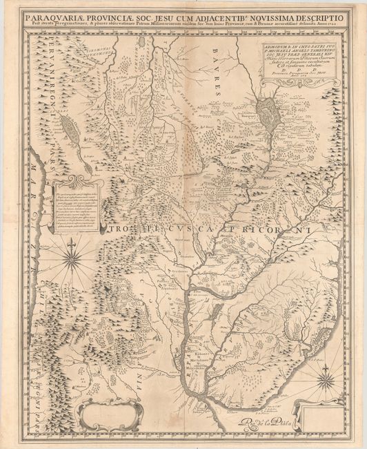
Auction 175, Lot 323
Subject: Central South America, Paraguay
Paraquariae Provinciae Soc. Jesu cum Adjacentib. Novissima Descriptio..., 1722
Size: 21.9 x 28.4 inches (55.6 x 72.1 cm)
Estimate: $4,750 - $6,000
Pre-Publication Proof of Extremely Rare Jesuit Map of Paraguay
Unsold
Closed on 11/13/2019
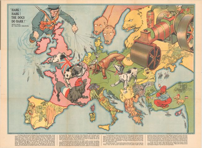
Auction 175, Lot 356
Subject: Europe, World War I
Bacon, G. W. & Company
Hark! Hark! The Dogs Do Bark!, 1914
Size: 27.6 x 19 inches (70.1 x 48.3 cm)
Estimate: $1,600 - $2,000
Rare Political Caricature Pocket Map Depicting European Countries as Dogs
Sold for: $1,100
Closed on 11/13/2019
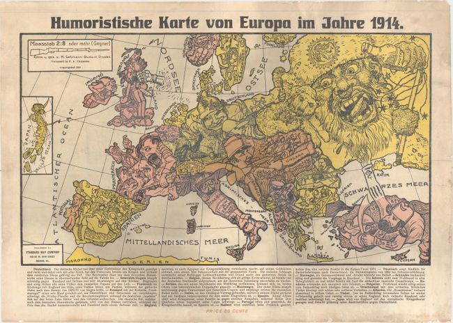
Auction 175, Lot 357
Subject: Europe, World War I
Humoristische Karte von Europa im Jahre 1914, 1914
Size: 18.9 x 10.8 inches (48 x 27.4 cm)
Estimate: $1,100 - $1,500
Rare Pro-German Propaganda Targeting German Immigrants within the United States
Unsold
Closed on 11/13/2019
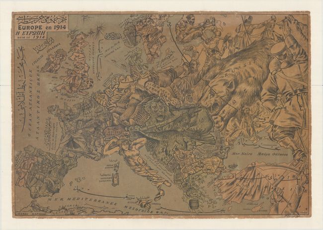
Auction 175, Lot 358
Subject: Europe, World War I
Europe en 1914, 1914
Size: 26.1 x 17.9 inches (66.3 x 45.5 cm)
Estimate: $1,200 - $1,500
Scarce Tri-Lingual Propaganda Map from WWI in Support of Central Powers
Sold for: $900
Closed on 11/13/2019
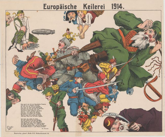
Auction 175, Lot 359
Subject: Europe, World War I
Europaische Keilerei 1914, 1914
Size: 17.1 x 13.3 inches (43.4 x 33.8 cm)
Estimate: $1,400 - $1,700
German Propaganda Map Depicting a "European Brawl"
Sold for: $1,500
Closed on 11/13/2019
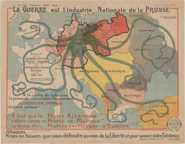
Auction 175, Lot 360
Subject: Europe, World War I
La Guerre est l'Industrie Nationale de la Prusse, 1917
Size: 11.5 x 8.4 inches (29.2 x 21.3 cm)
Estimate: $750 - $900
Rare French Propaganda Map Showing Prussian Octopus
Sold for: $550
Closed on 11/13/2019
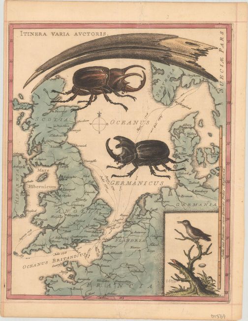
Auction 175, Lot 380
Subject: Northern Europe
Itinera Varia Auctoris, 1746
Size: 8.2 x 10.1 inches (20.8 x 25.7 cm)
Estimate: $240 - $300
The "Beetle" Map
Sold for: $200
Closed on 11/13/2019
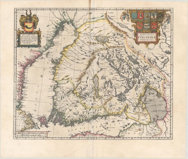
Auction 175, Lot 386
Subject: Finland
Blaeu, Johannes
Magnus Ducatus Finlandiae Auct. Andrea Buraeo Sueco, 1659
Size: 20.6 x 17 inches (52.3 x 43.2 cm)
Estimate: $1,400 - $1,700
The First Separately Published Map of Finland
Unsold
Closed on 11/13/2019
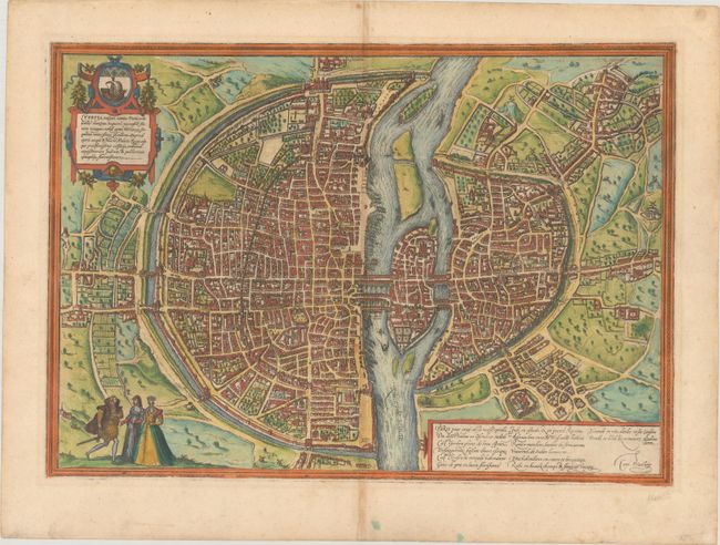
Auction 175, Lot 419
Subject: Paris, France
Braun & Hogenberg
Lutetia vulgari Nomine Paris, Urbs Galliae Maxima, Sequana Navigabili Flumine Irrigatur…, 1575
Size: 19 x 13.3 inches (48.3 x 33.8 cm)
Estimate: $2,750 - $3,500
Braun & Hogenberg's Plan of Paris
Sold for: $2,000
Closed on 11/13/2019
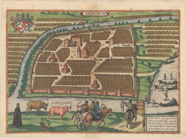
Auction 175, Lot 476
Subject: Moscow, Russia
Braun & Hogenberg
Moscauw, 1575
Size: 19.4 x 13.8 inches (49.3 x 35.1 cm)
Estimate: $2,400 - $3,000
Braun & Hogenberg's First Plan of Moscow
Sold for: $1,500
Closed on 11/13/2019
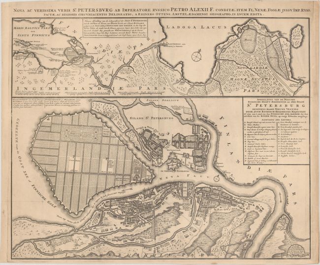
Auction 175, Lot 477
Subject: St. Petersburg, Russia
Ottens, Reiner and Joshua
Nova ac Verissima Urbis St. Petersburg ab Imperatore Russico Petro Alexii F. Conditae, Item Fl. Nevae, Fossae Jussu Imp. Russ..., 1720
Size: 23.3 x 18.8 inches (59.2 x 47.8 cm)
Estimate: $1,600 - $1,900
Great Map Illustrating Peter the Great's Plans for St. Petersburg
Unsold
Closed on 11/13/2019
Auction 175, Lot 554
Subject: Holy Land
Mortier, Pierre
[2 Volumes] Historie des Ouden en Nieuwen Testaments, Verrykt met meer dan Vierhonderd Printverbeeldingen in Koper Gesneeden..., 1700
Size: 11.8 x 18 inches (30 x 45.7 cm)
Estimate: $1,800 - $2,100
Mortier's Dutch History of the Old and New Testaments with Five Maps
Sold for: $1,000
Closed on 11/13/2019
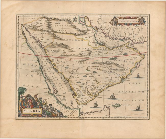
Auction 175, Lot 560
Subject: Arabia
Blaeu, Johannes
Arabia, 1663
Size: 20.9 x 16.4 inches (53.1 x 41.7 cm)
Estimate: $2,000 - $2,300
Blaeu's Uncommon Map of the Arabian Peninsula
Sold for: $1,350
Closed on 11/13/2019
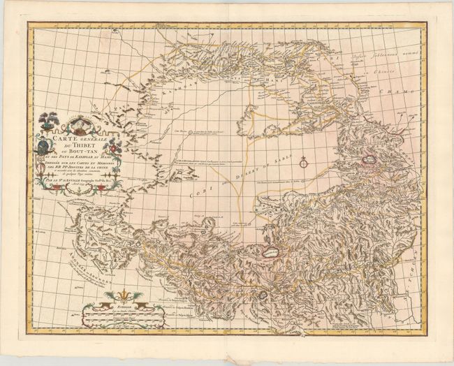
Auction 175, Lot 569
Subject: Central Asia, Tibet
Anville, Jean Baptiste Bourguignon d'
Carte Generale du Thibet ou Bout-Tan et des Pays de Kashgar et Hami Dressee sur les Cartes et Memoires des RR PP Jesuites de la Chine..., 1733
Size: 23 x 18.1 inches (58.4 x 46 cm)
Estimate: $1,200 - $1,500
First European Map of Tibet
Sold for: $750
Closed on 11/13/2019
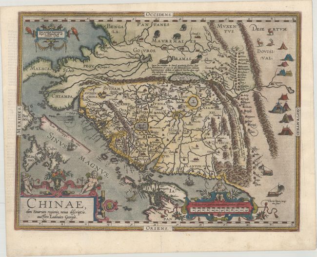
Auction 175, Lot 582
Subject: China
Ortelius, Abraham
Chinae, olim Sinarum Regionis, Nova Descriptio. Auctore Ludovico Georgio, 1584
Size: 18.8 x 14.5 inches (47.8 x 36.8 cm)
Estimate: $5,500 - $6,500
The First European-Printed Map of China
Sold for: $4,000
Closed on 11/13/2019
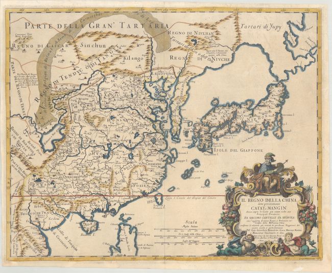
Auction 175, Lot 589
Subject: China, Korea & Japan
Cantelli da Vignola/de Rossi
Il Regno della China detto Presentemente Catay, e Mangin. Diviso Sopra le Carte piu Esatte nelle sue Principali Provincie..., 1682
Size: 21.6 x 17.2 inches (54.9 x 43.7 cm)
Estimate: $1,800 - $2,100
Scarce Italian Map of the Chinese Empire
Unsold
Closed on 11/13/2019
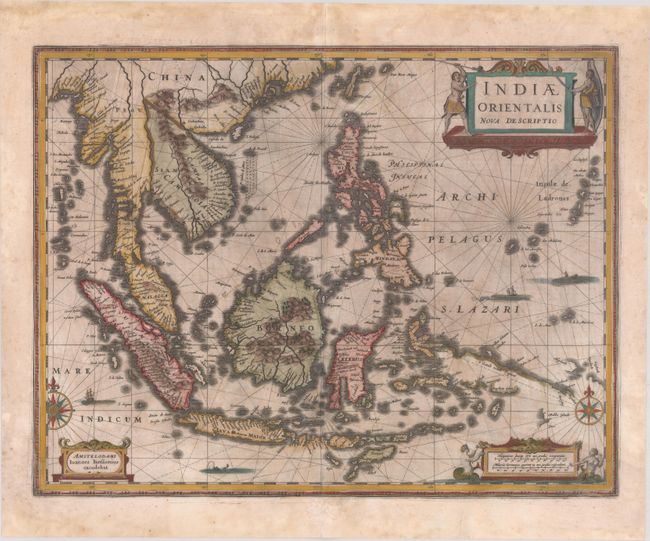
Auction 175, Lot 591
Subject: Southeast Asia
Jansson, Jan
Indiae Orientalis Nova Descriptio, 1647
Size: 19.9 x 15.4 inches (50.5 x 39.1 cm)
Estimate: $1,200 - $1,500
Includes Discoveries Made by the Dutch "Duyfken" Exploration
Sold for: $1,100
Closed on 11/13/2019
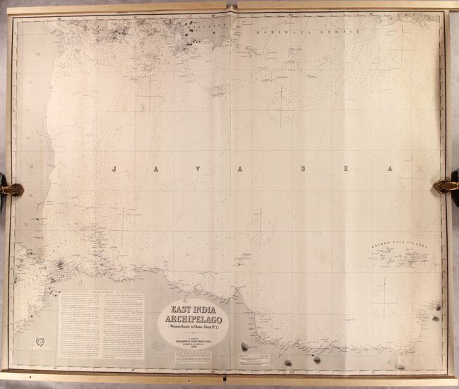
Auction 175, Lot 592
Subject: Southeast Asia
Imray, James
[Lot of 6] East India Archipelago [Western Route to China, Chart No. 1, 2, 3, 4, 5, & 6], 1879-84
Size: See Description
Estimate: $1,400 - $1,700
Complete Set of Blueback Charts of the South China Sea
Sold for: $1,000
Closed on 11/13/2019
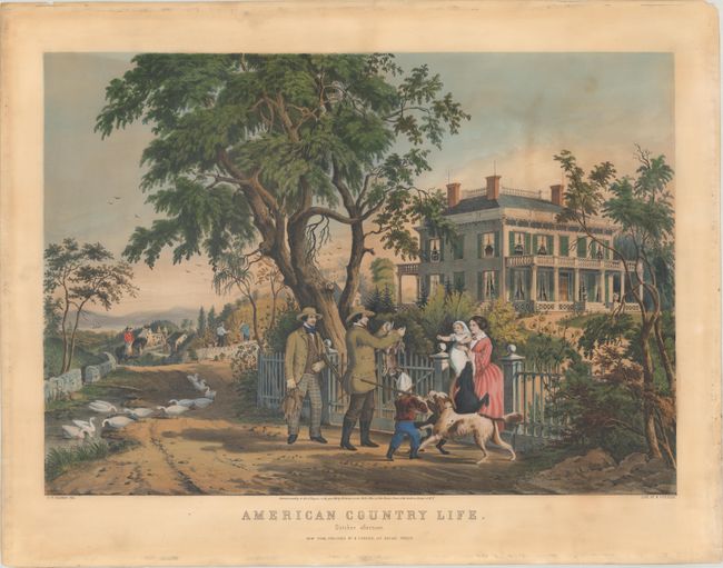
Auction 175, Lot 653
Subject: Prints - American Life
Currier & Ives
American Country Life. October Afternoon, 1855
Size: 23.8 x 16.7 inches (60.5 x 42.4 cm)
Estimate: $2,500 - $3,250
Splendid View of Country Life in Autumn
Unsold
Closed on 11/13/2019
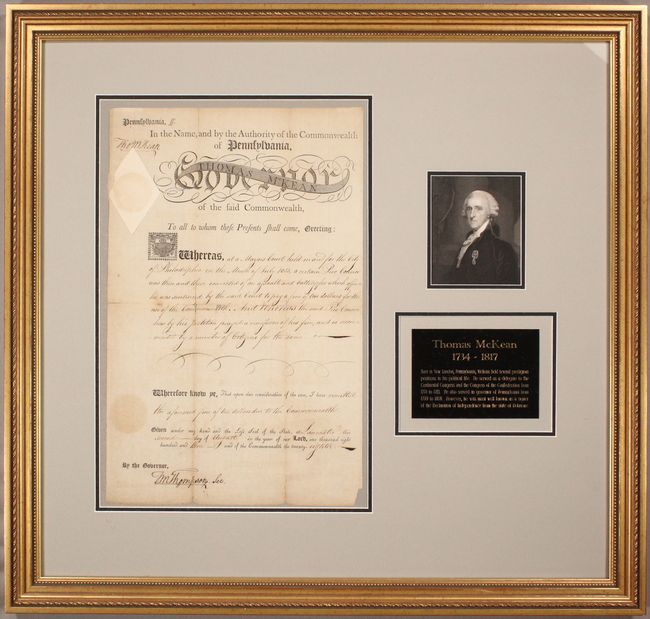
Auction 175, Lot 661
Subject: Document - Thomas McKean
[Governor Thomas McKean Document], 1803
Size: 10 x 15.5 inches (25.4 x 39.4 cm)
Estimate: $350 - $450
Document Signed by Thomas McKean, Signer of Declaration of Independence
Sold for: $300
Closed on 11/13/2019
54 lots
Page 1 of 2