Subject: Europe, World War I
Period: 1914 (dated)
Publication:
Color: Hand Color
Size:
26.1 x 17.9 inches
66.3 x 45.5 cm
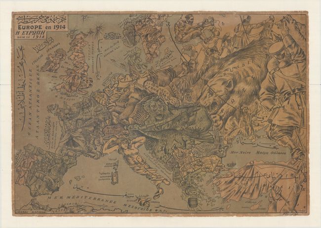
This fascinating and scarce satirical map of World War I was created by P. Petric. This unusual tri-lingual map has the title and all place names translated into Greek and Arabic in addition to French. Petric closely modeled his map after Wilhelm Kaspar's Momentaufnahme von Europa und Halbasien published by Graht & Kaspar. The key countries involved in the war are represented by human or animal caricatures with various props that help illustrate the situation.
At the center of the conflict are Germany, Austria and Russia. Germany is represented by both an eagle, attempting to bite the hand of the French soldier, and a Deutsche Michel (an ordinary or average German), who is doing the splits to hold back the French soldiers with one foot while the other foot kicks a Russian soldier and his right hand clenches Belgium. Austria is depicted as two ferocious animals: a lion holding a gun and shooting a bullet at the Russian bear, and a double-headed eagle pecking at the Balkans. The Russian bear, surrounded by Russian soldiers and scenes of civil strife, attacks the Austrian lion from behind. The French soldiers simply flee the German onslaught. A frightened-looking British soldier sits astride a bulldog while a venomous snake strikes from behind. Turkey flies a Turkish flag while holding a scimitar and shooting a bullet into the foot of a Russian soldier. Other countries are depicted as passive, including Italy as a Roman goddess statue, Sweden and Norway as a woman trying to protect her material resources, a Swiss sheep, and a drunk Spaniard sitting in an orchard.
Although the human personification of continents and countries can be seen as early as the 14th century (on maps by Opicinus de Canestris), human and animal metaphors on maps reached a new level in Europe between 1845 and 1945 with political cartoon maps. The rise of these satirical maps reflected the momentous political and cultural changes that occurred during the time. Political leaders were caricaturized and European nations were given symbolic identities that lent humor and accessibility to the geographical map. Based on popular stereotypes, these visual representations even found their way into the classroom to help bring geography and politics to life. Original serio-comic maps are very scarce due to their ephemeral nature.
This map appears to be particularly scarce, as we were not able to find any listings with dealers or in institutions.
References:
Condition: B
Toned with light soiling and a few abrasions. Backed in heavy tissue to provide support and repair separations along the folds, a few tears in the image, and some tiny chips and tears along the edges of the sheet, with the tissue backing extending beyond the original sheet to create margins for framing.