Subject: Europe, World War I
Period: 1914 (dated)
Publication:
Color: Printed Color
Size:
17.1 x 13.3 inches
43.4 x 33.8 cm
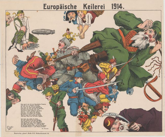
This German propaganda map was published at the beginning of WWI to convince Germans of the power and early successes of the Central Powers' military. As the title suggests, the imagery shows a European brawl, with a jumble of soldiers and civilians forming a rough outline of the continent. The Central Powers are all depicted as soldiers, armed with bayonets, swords and spears and appear to be successfully attacking the Entente Powers, who cower in fear rather than fight back. Neutral countries are depicted as peaceful civilians rather than soldiers. A large zeppelin is shown in the North Sea headed toward England, indicating that this map was likely published in 1915 after the German raid on England in January 1915. A short poem by Dr. Storch explains that although there were formerly many concerts in Europe and everything was in "harmony," the Serbs destroyed the peace, and Ivan (Russia), John Bull (England) and Marianne (France) joined in supporting the Serbs. However Michel (Germany) will give the four "parasites" what they deserve, and soon concerts will be able to resume, with Michel holding the conductor's baton. And the first concert piece will be "The Guard on the Rhine." Published by Kunstverlag "Junos" in Berlin.
Although the human personification of continents and countries can be seen as early as the 14th century (on maps by Opicinus de Canestris), human and animal metaphors on maps reached a new level in Europe between 1845 and 1945 with political cartoon maps. The rise of these satirical maps reflected the momentous political and cultural changes that occurred during the time. Political leaders were caricaturized and European nations were given symbolic identities that lent humor and accessibility to the geographical map. Based on popular stereotypes, these visual representations even found their way into the classroom to help bring geography and politics to life. Original serio-comic maps are very scarce due to their ephemeral nature.
References:
Condition: A
Excellent impression and color on a bright sheet with a couple of small spots at top left. A short tear at bottom center was previously repaired with cello tape, which has since been removed and professionally repaired, although with a very faint stain remaining.