Showing Featured Lots(remove filter)
Showing results for:Auction 154
Catalog Archive
70 lots
Page 1 of 2
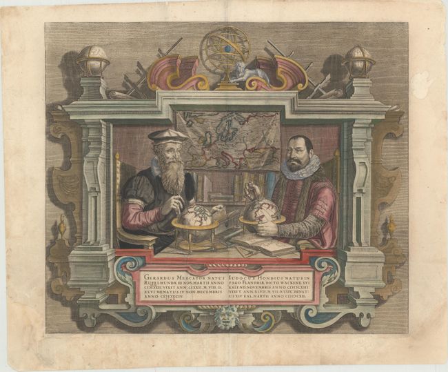
Auction 154, Lot 7
Subject: Title Pages - Portraits
Hondius
Gerardus Mercator … Iudocus Hondius …, 1623
Size: 17.8 x 15.3 inches (45.2 x 38.9 cm)
Estimate: $1,800 - $2,100
Famous Portraits of Mercator and Jodocus Hondius
Unsold
Closed on 9/16/2015
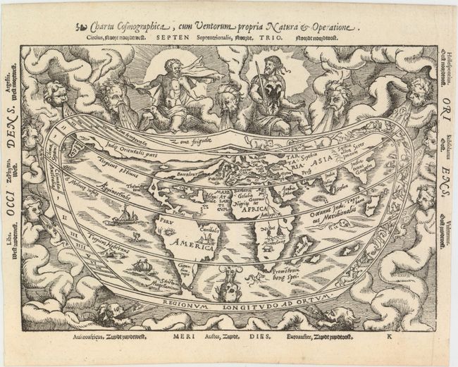
Auction 154, Lot 10
Subject: World
Apianus, Peter Bienewitz
Charta Cosmographica, cum Ventorum Propria Natura & Operatione, 1564
Size: 10.9 x 7.6 inches (27.7 x 19.3 cm)
Estimate: $4,000 - $4,750
Apianus' Popular Cordiform World Map
Sold for: $3,250
Closed on 9/16/2015
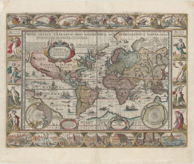
Auction 154, Lot 13
Subject: World
Kaerius/Jansson
Nova Totius Terrarum Orbis Geographica ac Hydrographica Tabula, 1637
Size: 21.1 x 15.7 inches (53.6 x 39.9 cm)
Estimate: $12,000 - $14,000
Jansson's Magnificent Carte-a-Figures World Map
Sold for: $7,500
Closed on 9/16/2015
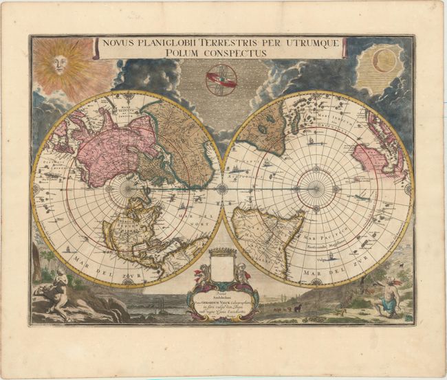
Auction 154, Lot 17
Subject: World
Blaeu/Valck
Novus Planiglobii Terrestris per Utrumque Polum Conspectus, 1695
Size: 21.3 x 16.1 inches (54.1 x 40.9 cm)
Estimate: $5,500 - $7,000
Superb World Map on a Polar Projection
Sold for: $3,750
Closed on 9/16/2015
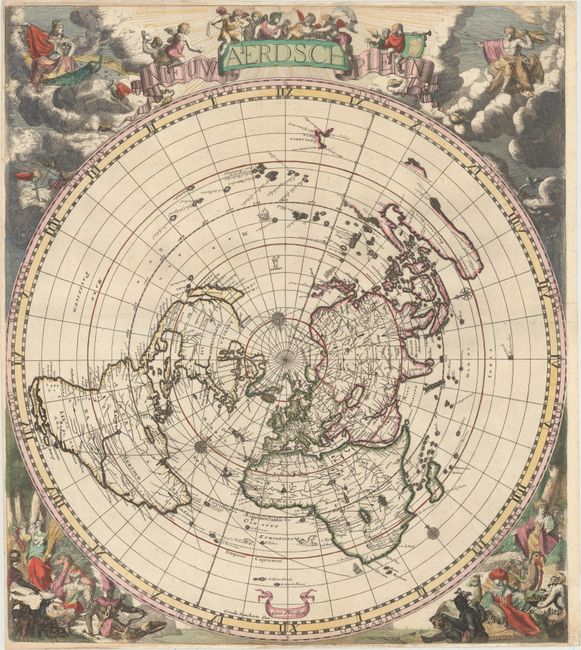
Auction 154, Lot 18
Subject: World
Robijn (Robyn), Jacobus
Nieuw Aerdsch Pleyn, 1700
Size: 20.9 x 23.7 inches (53.1 x 60.2 cm)
Estimate: $6,000 - $7,500
Rare World Map on a Singular Polar Projection
Sold for: $4,000
Closed on 9/16/2015
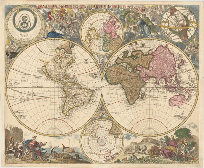
Auction 154, Lot 20
Subject: World
Schenk, Pieter
Haemisphaeriorum Tabula Carthesiana, 1700
Size: 23.4 x 19.3 inches (59.4 x 49 cm)
Estimate: $5,000 - $6,500
Rare Decorative World Map with Geographical Misconceptions
Sold for: $4,000
Closed on 9/16/2015
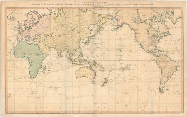
Auction 154, Lot 28
Subject: World
Faden, William
A General Chart Exhibiting the Discoveries Made by Captn. James Cook in This and His Two Preceding Voyages; with the Tracks of the Ships Under His Command, by Lieutt. Robers of His Majesty's Royal Navy, 1784
Size: 35.4 x 21.2 inches (89.9 x 53.8 cm)
Estimate: $1,400 - $1,700
Scarce Faden Edition of Roberts' Map Depicting Cook's Voyages
Sold for: $700
Closed on 9/16/2015
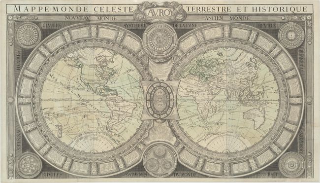
Auction 154, Lot 29
Subject: World
Brion de la Tour/Desnos
Mappe-Monde Celeste Terrestre et Historique Augmentee des Vouages et Decouvertes du Celebre Capitaine Cook..., 1786
Size: 37 x 21.3 inches (94 x 54.1 cm)
Estimate: $4,000 - $5,000
Brion de la Tour/Desnos Reissue of Jaugeon's Ornate and Informative Double-Hemisphere World Map
Sold for: $2,400
Closed on 9/16/2015
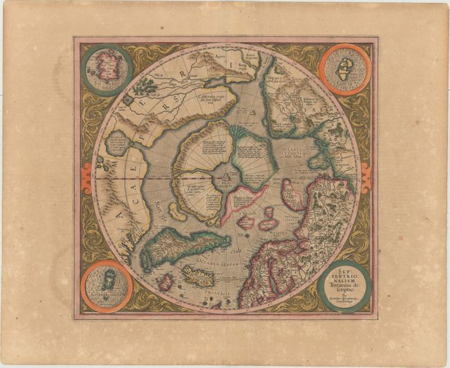
Auction 154, Lot 36
Subject: North Pole
Mercator/Hondius
Septentrionalium Terrarum Descriptio, 1619
Size: 15.5 x 14.5 inches (39.4 x 36.8 cm)
Estimate: $2,000 - $2,300
The First Printed Map Devoted to the Arctic in Full Original Color
Sold for: $1,800
Closed on 9/16/2015
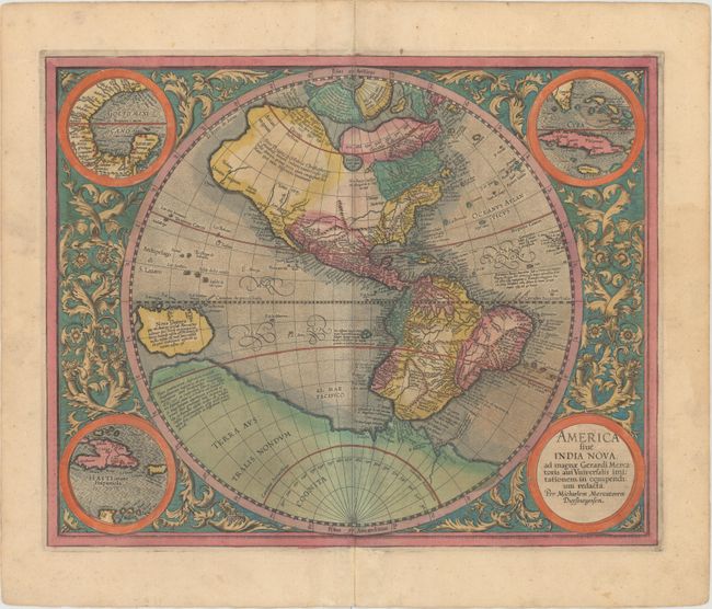
Auction 154, Lot 48
Subject: Western Hemisphere - America
Mercator, Michael
America sive India Nova, ad Magnae Gerardi Mercatoris aui Universalis Imitationem in Compendium Redacta, 1609
Size: 18.1 x 14.4 inches (46 x 36.6 cm)
Estimate: $4,500 - $5,500
Mercator's Foundation Map for the Americas
Sold for: $3,000
Closed on 9/16/2015
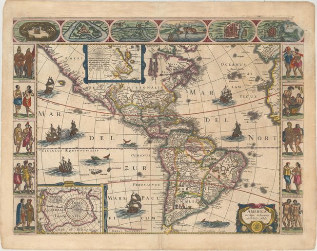
Auction 154, Lot 50
Subject: Western Hemisphere - America
Hondius/Jansson
America Noviter Delineata, 1632
Size: 21.8 x 16.3 inches (55.4 x 41.4 cm)
Estimate: $9,500 - $12,000
Jansson's Rare Carte-a-Figures Map of the Americas
Unsold
Closed on 9/16/2015
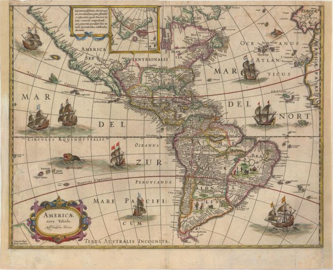
Auction 154, Lot 51
Subject: Western Hemisphere - America
Blaeu, Willem
Americae Nova Tabula, 1633
Size: 18.3 x 14.2 inches (46.5 x 36.1 cm)
Estimate: $2,200 - $2,500
Rare Edition of Blaeu's Map of the Americas
Unsold
Closed on 9/16/2015
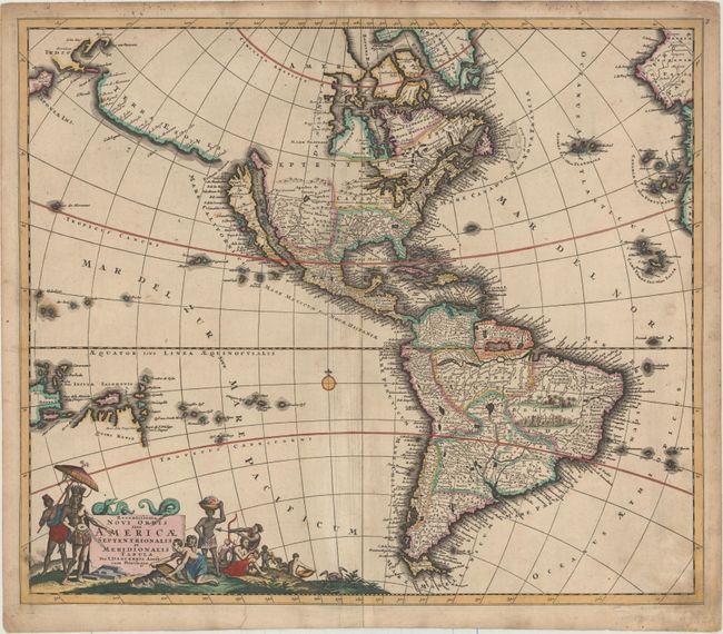
Auction 154, Lot 53
Subject: Western Hemisphere - America
Danckerts, Justus
Recentissima Novi Orbis sive Americae Septentrionalis et Meridionalis Tabula, 1696
Size: 22.6 x 19.4 inches (57.4 x 49.3 cm)
Estimate: $1,400 - $1,600
Danckerts' Fascinating and Decorative Map of the Western Hemisphere
Sold for: $850
Closed on 9/16/2015
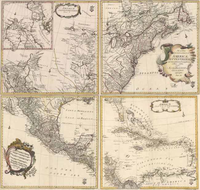
Auction 154, Lot 65
Subject: North America
Von Euler, Leonhard
[On 4 Sheets] Mappa Geographica Americae Septentrionalis ad Emendatiora Exemplaria..., 1760
Size: 14.4 x 13.8 inches (36.6 x 35.1 cm)
Estimate: $1,400 - $1,700
Euler's Scarce 4-Sheet Map of North America
Sold for: $900
Closed on 9/16/2015
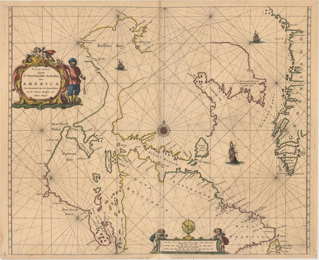
Auction 154, Lot 83
Subject: Eastern Canada and Greenland
Goos, Pieter
Paskaert Zynde de Noordelijckste Zeekusten van America van Groenland door de Straet Davis en de Straet Hudson tot Terra Neuf, 1666
Size: 21.4 x 17.5 inches (54.4 x 44.5 cm)
Estimate: $1,200 - $1,500
Goos' Uncommon Sea Chart Centered on Hudson Strait
Unsold
Closed on 9/16/2015
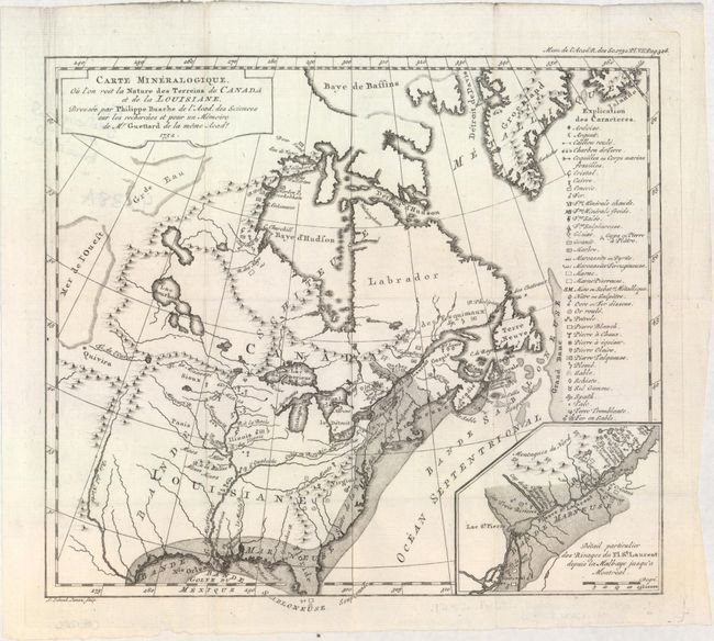
Auction 154, Lot 97
Subject: Colonial Eastern United States & Canada
Guettard, Jean Etienne
Carte Mineralogique, ou l'on voit la Nature des Terreins du Canada et de la Louisiane..., 1752
Size: 12.1 x 10.9 inches (30.7 x 27.7 cm)
Estimate: $1,200 - $1,500
First Geological Map of North America
Sold for: $900
Closed on 9/16/2015
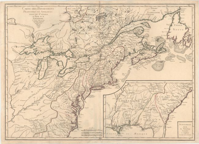
Auction 154, Lot 98
Subject: Colonial Eastern United States & Canada
Longchamp, S. G. (Sieur)
Carte des Possessions Francoises et Angloises dans le Canada, et Partie de la Louisiane, 1756
Size: 30 x 21.6 inches (76.2 x 54.9 cm)
Estimate: $1,600 - $1,900
First State of Longchamp's Map of the Theater of the French and Indian War
Sold for: $1,400
Closed on 9/16/2015
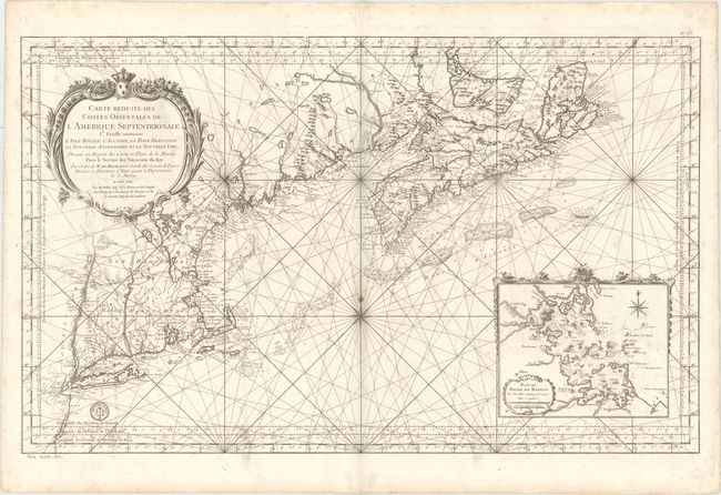
Auction 154, Lot 107
Subject: Colonial Northeastern United States & Canada
Bellin, Jacques Nicolas
Carte Reduite des Costes Orientales de l'Amerique Septentrionale 1re. Feuille Contenant l'Isle Royale, l'Accadie, la Bay Francoise, la Nouvelle Angleterre et la Nouvelle Yorc..., 1757
Size: 34.9 x 21.6 inches (88.6 x 54.9 cm)
Estimate: $2,400 - $3,000
Scarce Large-Scale Chart of the Coast of New England
Unsold
Closed on 9/16/2015
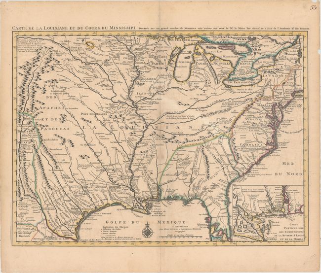
Auction 154, Lot 122
Subject: Colonial Eastern United States, Louisiana Territory
Delisle/Covens & Mortier
Carte de la Louisiane et du Cours du Mississipi Dressee sur un Grand Nombre de Memoires Entr' Autres sur Ceux de Mr. le Maire..., 1730
Size: 23.6 x 17.3 inches (59.9 x 43.9 cm)
Estimate: $2,750 - $3,500
Delisle's Influential Map of the Louisiana Territory
Unsold
Closed on 9/16/2015
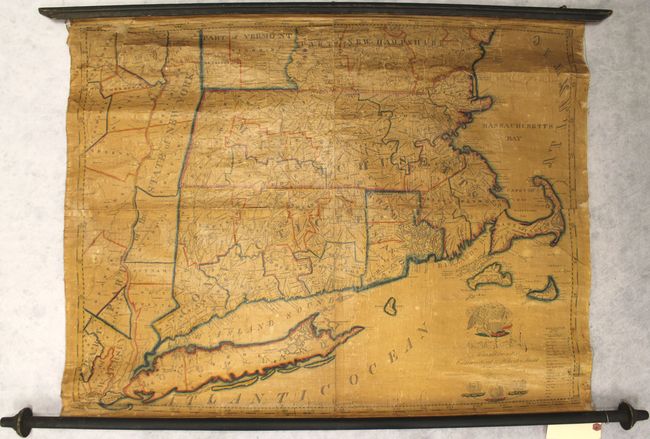
Auction 154, Lot 136
Subject: New England - United States
Ruggles, Edward
A Map of Massachusetts Connecticut and Rhodeisland..., 1824
Size: 36.3 x 28.7 inches (92.2 x 72.9 cm)
Estimate: $1,500 - $2,000
Ruggles' Rare Map of Southern New England
Sold for: $750
Closed on 9/16/2015
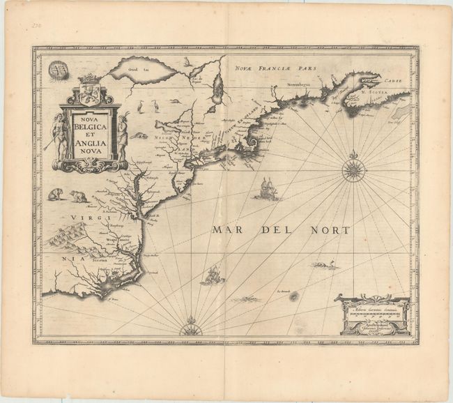
Auction 154, Lot 137
Subject: Colonial New England & Mid-Atlantic United States
Jansson, Jan
Nova Belgica et Anglia Nova, 1652
Size: 19.8 x 15.3 inches (50.3 x 38.9 cm)
Estimate: $1,600 - $1,900
Jansson's Influential Map of the East Coast
Sold for: $950
Closed on 9/16/2015
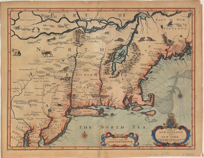
Auction 154, Lot 139
Subject: Colonial New England & Mid-Atlantic United States
Speed/Lamb
A Map of New England and New York, 1676
Size: 19.7 x 15 inches (50 x 38.1 cm)
Estimate: $4,500 - $5,500
"Speed" Map of New England
Sold for: $2,500
Closed on 9/16/2015
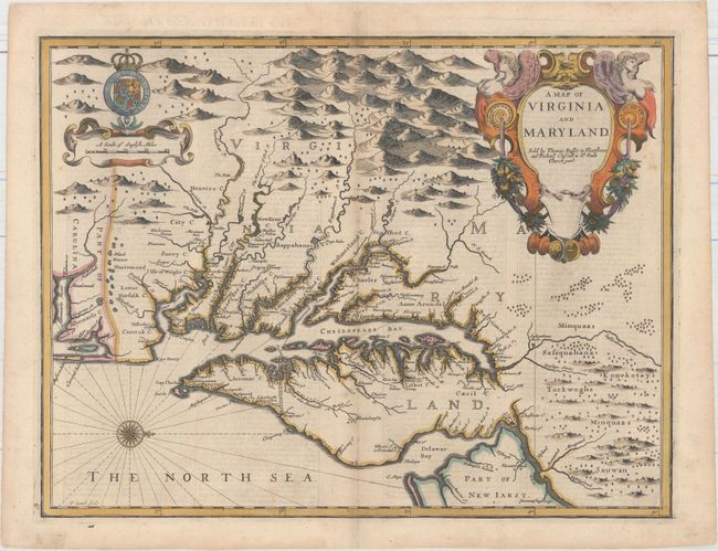
Auction 154, Lot 142
Subject: Colonial Mid-Atlantic United States
Speed/Lamb
A Map of Virginia and Maryland, 1676
Size: 19.4 x 14.9 inches (49.3 x 37.8 cm)
Estimate: $5,000 - $6,000
The First Printed Map to Draw Upon the Legendary Herrman Map of the Chesapeake Bay
Unsold
Closed on 9/16/2015
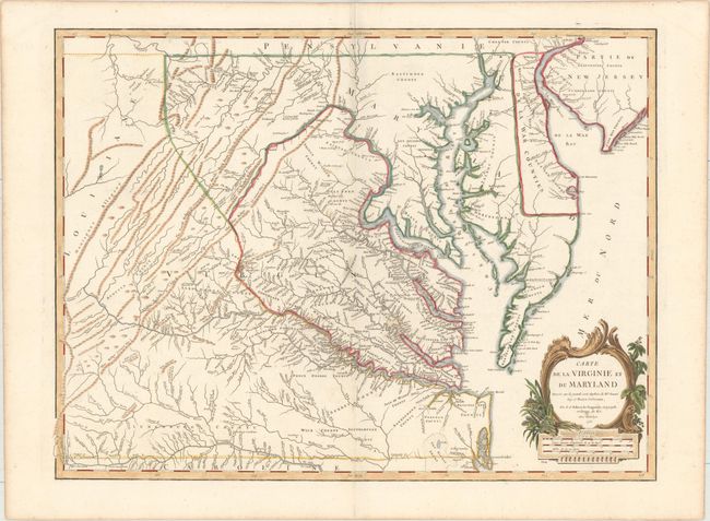
Auction 154, Lot 144
Subject: Colonial Mid-Atlantic United States
Robert de Vaugondy, Didier
Carte de la Virginie et du Maryland Dressee sur la Grande Carte Angloise de Mrs. Josue Fry et Pierre Jefferson..., 1755
Size: 25.5 x 19.1 inches (64.8 x 48.5 cm)
Estimate: $2,750 - $3,500
An Essential Map of Virginia and Maryland
Sold for: $1,700
Closed on 9/16/2015
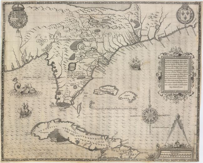
Auction 154, Lot 154
Subject: Colonial Southeast, Florida and Cuba
Bry, Theodore de
Floridae Americae Provinciae Recens & Exactissima Descriptio Auctore Iacobo le Moyne..., 1591
Size: 17.9 x 14.5 inches (45.5 x 36.8 cm)
Estimate: $9,500 - $12,000
De Bry's Influential Map of Colonial North America
Sold for: $5,000
Closed on 9/16/2015
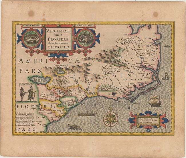
Auction 154, Lot 155
Subject: Colonial Southeast United States
Hondius, Jodocus
Virginiae Item et Floridae Americae Provinciarum, Nova Descriptio, 1628
Size: 19.3 x 13.6 inches (49 x 34.5 cm)
Estimate: $2,200 - $3,000
A Seminal Map of the Southeast and Early American Cartography
Unsold
Closed on 9/16/2015
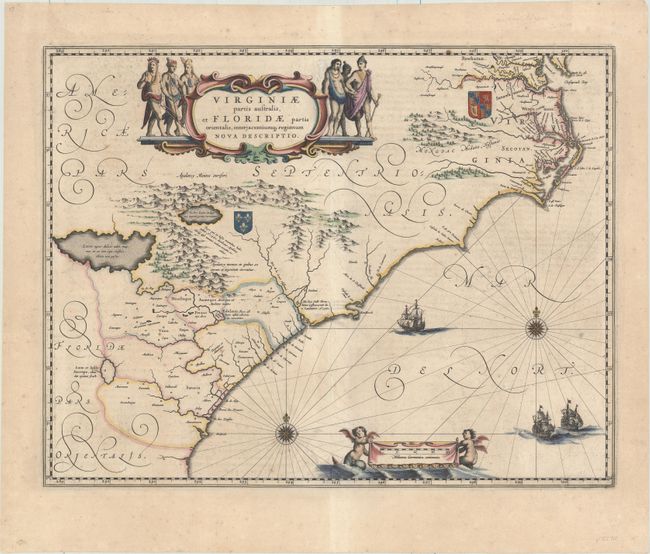
Auction 154, Lot 156
Subject: Colonial Southeast United States
Blaeu, Willem
Virginiae Partis Australis, et Floridae Partis Orientalis, Interjacentiumq Regionum Nova Descriptio, 1640
Size: 19.7 x 15.2 inches (50 x 38.6 cm)
Estimate: $1,600 - $2,000
Blaeu's Decorative Map of the Southeast
Sold for: $850
Closed on 9/16/2015
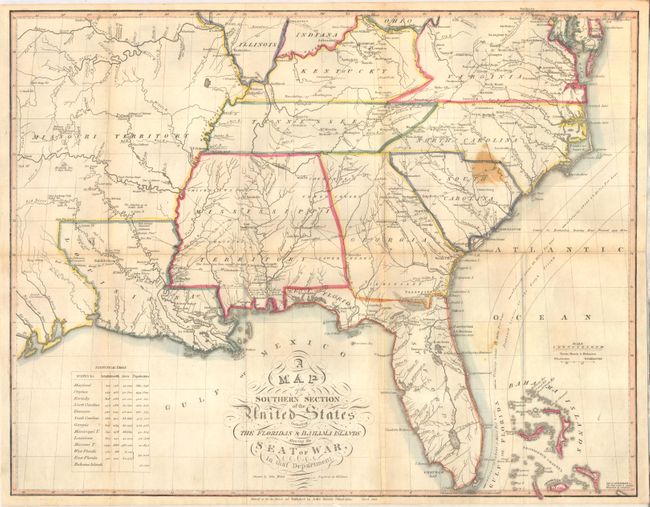
Auction 154, Lot 165
Subject: Southern United States
Melish, John
A Map of the Southern Section of the United States Including the Floridas & Bahama Islands Shewing the Seat of War, in That Department, 1813
Size: 20.9 x 16.4 inches (53.1 x 41.7 cm)
Estimate: $1,600 - $2,000
Melish's Rare Map of the Southern United States
Sold for: $1,200
Closed on 9/16/2015
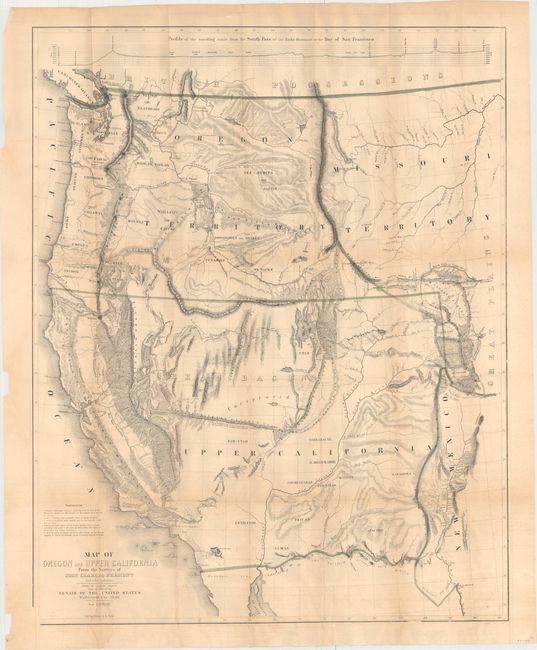
Auction 154, Lot 178
Subject: Western United States
Fremont/Preuss
Map of Oregon and Upper California from the Surveys of John Charles Fremont and Other Authorities, 1848
Size: 26.5 x 33 inches (67.3 x 83.8 cm)
Estimate: $1,500 - $1,800
Fremont's Large Map of the American West
Sold for: $1,700
Closed on 9/16/2015
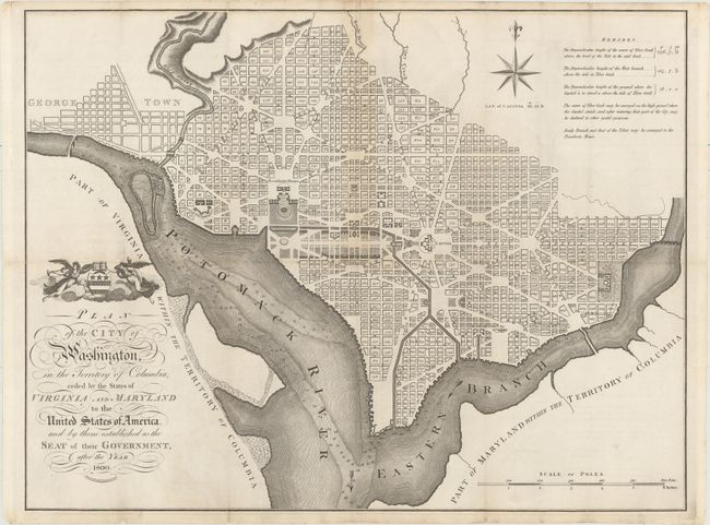
Auction 154, Lot 196
Subject: Washington, D.C.
Russell, John C.
Plan of the City of Washington, in the Territory of Columbia, Ceded by the States of Virginia and Maryland to the United States of America, and by Them Established as the Seat of Their Government, After the Year 1800, 1795
Size: 20.9 x 15.9 inches (53.1 x 40.4 cm)
Estimate: $2,400 - $3,000
Rare, Early Large Format Map of Washington D.C.
Sold for: $1,800
Closed on 9/16/2015
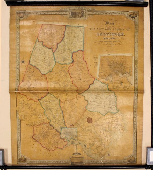
Auction 154, Lot 223
Subject: Baltimore, Maryland
[Lot of 2] Map of the City and County of Baltimore, Maryland, from Original Surveys [and] Plan of Baltimore & Vicinity Showing the Proposed Routes for Bringing Water from the Jone's and Gwynn's Falls & the Patapsco River..., 1851-53
Size: See Description
Estimate: $1,500 - $1,800
Scarce Wall Maps of Baltimore, Maryland
Sold for: $1,000
Closed on 9/16/2015
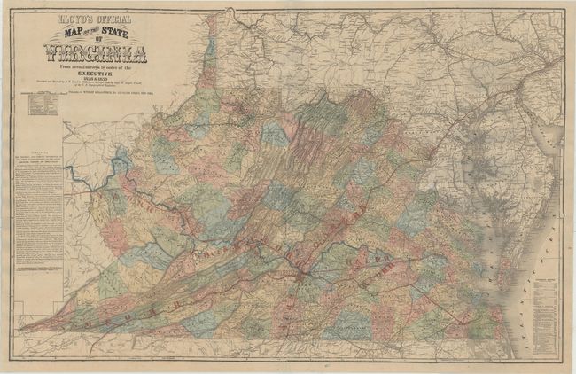
Auction 154, Lot 280
Subject: Virginia
Lloyd, James T.
Lloyd's Official Map of the State of Virginia From Actual Surveys by Order of the Executive 1828 & 1859..., 1862
Size: 47.3 x 30.4 inches (120.1 x 77.2 cm)
Estimate: $3,000 - $4,000
Extremely Rare Promotional Map with Railroad Overprint
Unsold
Closed on 9/16/2015
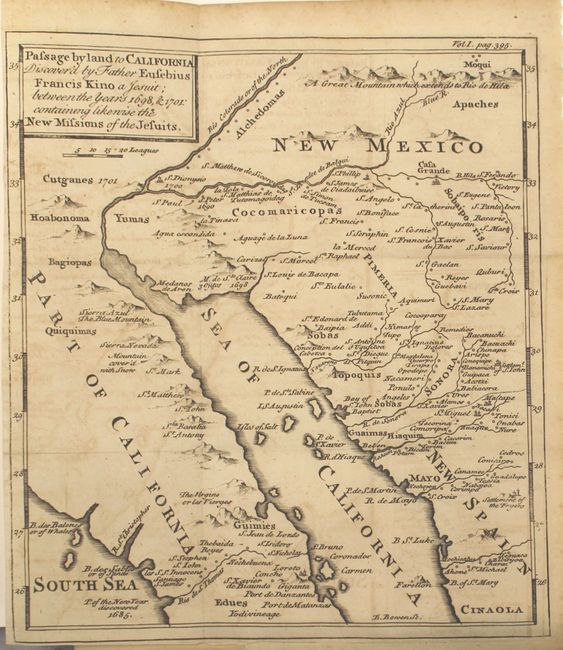
Auction 154, Lot 294
Subject: Southwestern United States & Mexico
Kino, Eusebio Francisco, SJ
Passage by Land to California Discovered by Father Eusebius Francis Kino a Jesuit; Between the Years 1698, & 1701: Containing Likewise the New Missions of the Jesuits [Bound in] Travels of the Jesuits, 1743
Size: 8 x 9.2 inches (20.3 x 23.4 cm)
Estimate: $1,000 - $1,300
Father Kino's Important Map of California
Sold for: $850
Closed on 9/16/2015
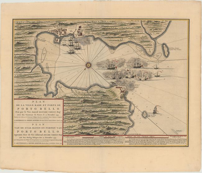
Auction 154, Lot 315
Subject: Portobelo, Panama
Mortier, Pierre
Plan de la Ville Rade et Forts de Porto Bello... / Plan van de Stad Haven en Forten van Porto Bello..., 1740
Size: 22.4 x 16.3 inches (56.9 x 41.4 cm)
Estimate: $2,000 - $2,300
Rare Chart of the Battle of Portobello
Sold for: $1,400
Closed on 9/16/2015
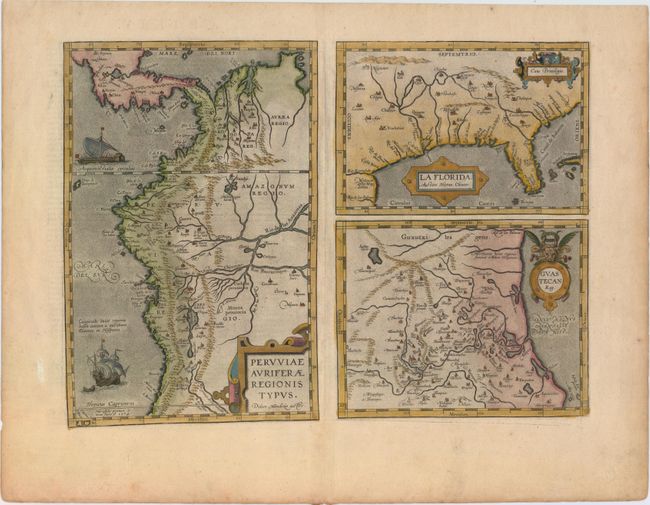
Auction 154, Lot 318
Subject: Gulf of Mexico, Florida & Peru
Ortelius, Abraham
Peruviae Auriferae Regionis Typus [on sheet with] La Florida [and] Guastecan, 1598
Size: 18.1 x 13.1 inches (46 x 33.3 cm)
Estimate: $1,600 - $1,900
The First Printed Map of the Southern United States
Sold for: $950
Closed on 9/16/2015
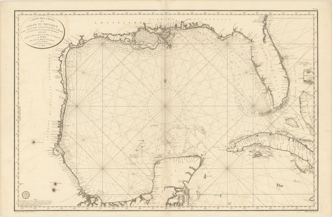
Auction 154, Lot 319
Subject: Gulf of Mexico and Cuba
Depot de la Marine
Carte des Cotes du Golfe du Mexique Compris Entre la Pointe Sud de la Presqu'Ile de la Floride et la Pointe Nord de la Presqu' Ile d'Yucatan..., 1800
Size: 35.6 x 23.6 inches (90.4 x 59.9 cm)
Estimate: $800 - $1,000
Important Map for the Texas Collector
Sold for: $600
Closed on 9/16/2015
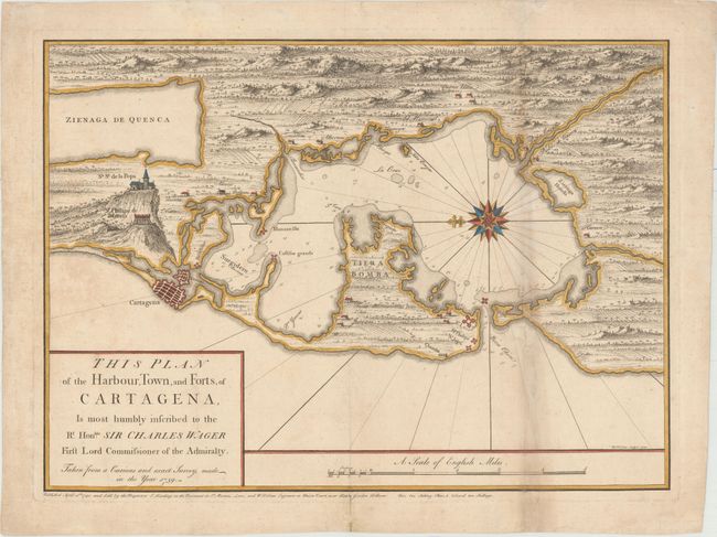
Auction 154, Lot 356
Subject: Cartagena, Colombia
Toms, William Henry
This Plan of the Harbour, Town, and Forts, of Cartagena, Is Most Humbly Inscribed to the Rt. Honble. Sir Charles Wager First Lord Commissioner of the Admiralty..., 1740
Size: 22.8 x 16.6 inches (57.9 x 42.2 cm)
Estimate: $600 - $750
Rare Chart Issued Prior to the Battle of Cartagena
Sold for: $950
Closed on 9/16/2015
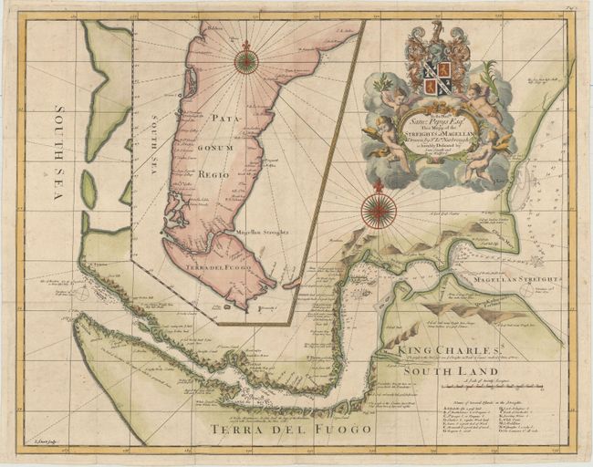
Auction 154, Lot 382
Subject: Strait of Magellan
Narbrough, John
To the Honble. Sam: Pepys Esqr. This Mapp of the Streights of Magellan Drawn by Sr Ion. Narbrough..., 1694
Size: 20.6 x 16.4 inches (52.3 x 41.7 cm)
Estimate: $1,800 - $2,200
First Edition of Narborough's Scarce Map of the Strait of Magellan
Sold for: $1,200
Closed on 9/16/2015
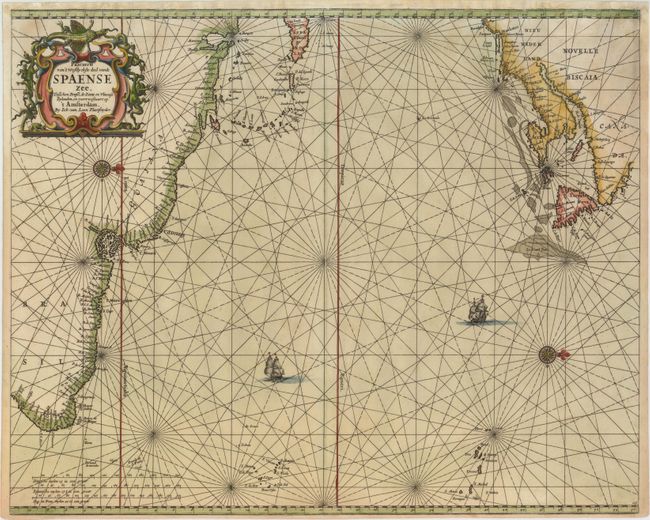
Auction 154, Lot 385
Subject: Atlantic Ocean
Loon, Jan van
Pascaerte van 't Westlyckste deel vande Spaense Zee, Tusschen Brasil, de Zoute en Vlaemse Eylanden, en Voortwestwart Op, 1661
Size: 21.2 x 17.1 inches (53.8 x 43.4 cm)
Estimate: $1,800 - $2,200
Scarce Chart of the North Atlantic Depicting the New England Coastline
Unsold
Closed on 9/16/2015
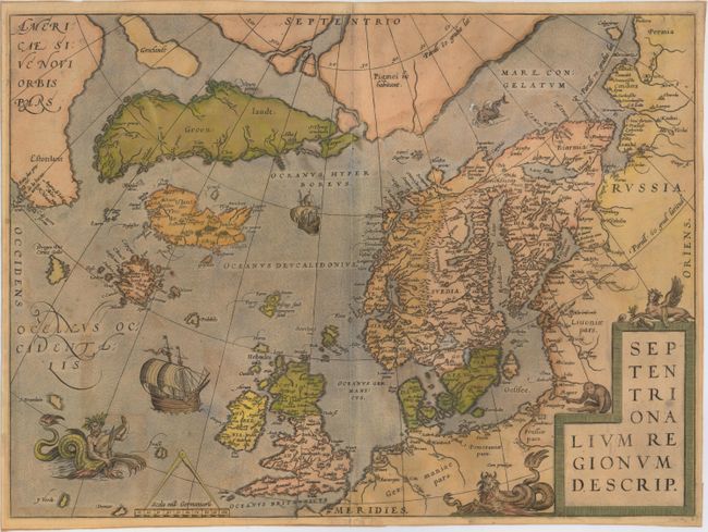
Auction 154, Lot 398
Subject: Arctic & Scandinavia
Ortelius, Abraham
Septentrionalium Regionum Descrip., 1584
Size: 19.3 x 14.2 inches (49 x 36.1 cm)
Estimate: $1,500 - $1,800
Ortelius' Map of the Arctic with Mythical Islands
Sold for: $1,100
Closed on 9/16/2015
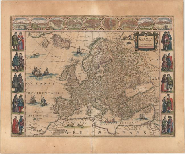
Auction 154, Lot 401
Subject: Europe
Blaeu, Willem
Europa Recens Descripta, 1644
Size: 21.9 x 16.2 inches (55.6 x 41.1 cm)
Estimate: $2,300 - $2,750
Blaeu's Carte-a-Figures Map of Europe
Sold for: $1,400
Closed on 9/16/2015
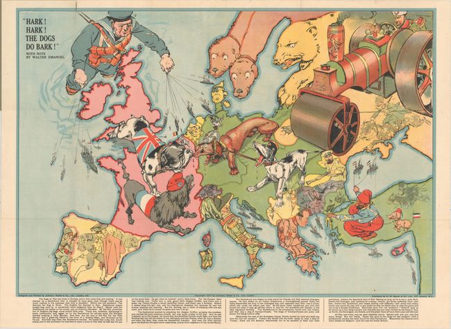
Auction 154, Lot 403
Subject: Europe
Bacon, G. W. & Company
Hark! Hark! The Dogs Do Bark!, 1914
Size: 27.6 x 19 inches (70.1 x 48.3 cm)
Estimate: $3,000 - $3,750
Rare Political Caricature Pocket Map of Europe
Sold for: $2,200
Closed on 9/16/2015
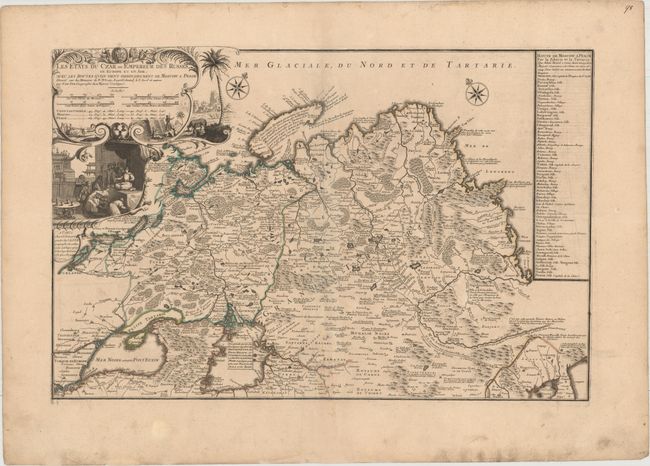
Auction 154, Lot 544
Subject: Russia
Fer, Nicolas de
Les Etats du Czar ou Empereur des Russes en Europe et en Asie, avec les Routes q'uon Tient Ordinairement de Moscow a Pekim..., 1722
Size: 25.4 x 16.7 inches (64.5 x 42.4 cm)
Estimate: $1,600 - $1,900
Rare Map of Russia Depicting An Overland Route from Moscow to Beijing
Sold for: $1,200
Closed on 9/16/2015
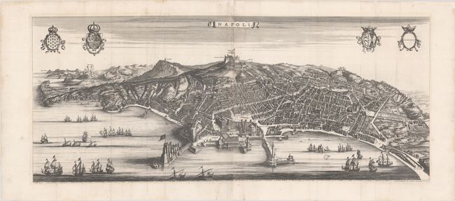
Auction 154, Lot 589
Subject: Naples, Italy
Blaeu/Mortier
Napoli, 1704
Size: 40.1 x 16.5 inches (101.9 x 41.9 cm)
Estimate: $2,000 - $2,400
A Rare and Stunning Panoramic View of Naples
Unsold
Closed on 9/16/2015
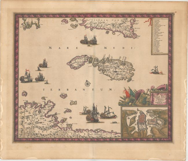
Auction 154, Lot 595
Subject: Malta
Wit, Frederick de
Insula Malta Accuratissime Delineata, Urbibus, et Fortalitiis, 1680
Size: 21.3 x 17.4 inches (54.1 x 44.2 cm)
Estimate: $1,600 - $2,000
One of the Most Decorative 17th Century Maps of Malta
Sold for: $1,200
Closed on 9/16/2015
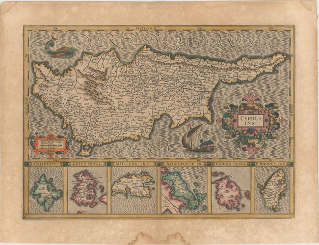
Auction 154, Lot 596
Subject: Cyprus
Hondius, Jodocus
Cyprus Ins. , 1619
Size: 19.4 x 13.9 inches (49.3 x 35.3 cm)
Estimate: $1,100 - $1,400
Hondius' Elegant Map of Cyprus
Sold for: $800
Closed on 9/16/2015
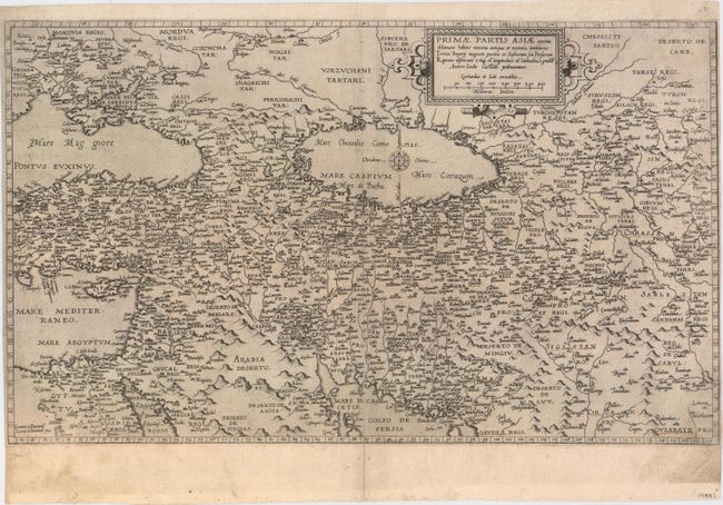
Auction 154, Lot 601
Subject: Middle East
Jode, Gerard de
Primae Partis Asiae Acurata Delineatio Habens Nomina Antiqua et Recentia Continens..., 1578
Size: 19.9 x 11.8 inches (50.5 x 30 cm)
Estimate: $2,750 - $3,500
De Jode's Rare Map of the Middle East
Sold for: $1,400
Closed on 9/16/2015
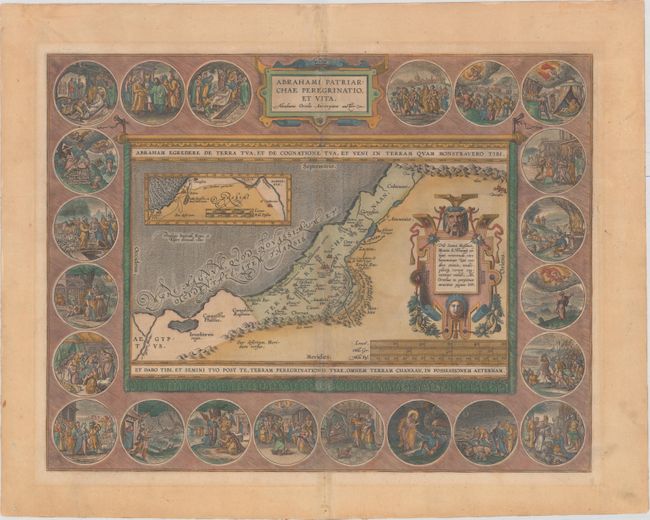
Auction 154, Lot 612
Subject: Holy Land
Ortelius, Abraham
Abrahami Patriarchae Peregrinatio, et Vita, 1586
Size: 18.2 x 14.1 inches (46.2 x 35.8 cm)
Estimate: $2,400 - $3,000
Elaborate Map of the Holy Land, Illustrating the Life of Abraham
Sold for: $1,200
Closed on 9/16/2015
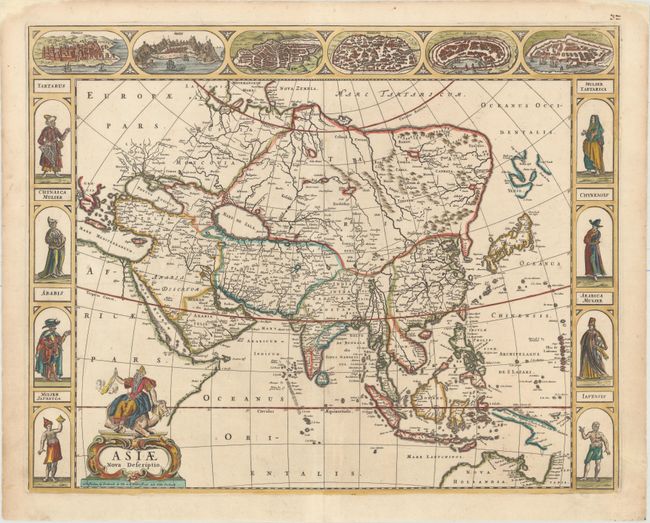
Auction 154, Lot 633
Subject: Asia
Wit, Frederick de
Asiae Nova Descriptio, 1660
Size: 22.1 x 17.6 inches (56.1 x 44.7 cm)
Estimate: $3,000 - $3,750
De Wit's Carte-a-Figures Map of Asia
Unsold
Closed on 9/16/2015
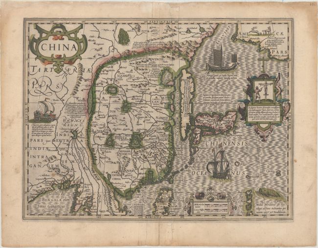
Auction 154, Lot 652
Subject: China, Korea & Japan
Mercator/Hondius
China, 1606
Size: 18.1 x 13.5 inches (46 x 34.3 cm)
Estimate: $1,900 - $2,200
Hondius' Map of China, Korea, and Japan
Sold for: $1,000
Closed on 9/16/2015
70 lots
Page 1 of 2