Subject: World
Period: 1786 (dated)
Publication:
Color: Hand Color
Size:
37 x 21.3 inches
94 x 54.1 cm
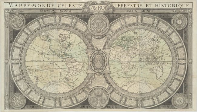
This rare, richly detailed double-hemisphere world map is a reissue of N. Jaugeon's map of 1688. The map has been updated to reflect the discoveries of Captain Cook. Tasmania is attached to Australia, and Nouvelle Guinee Terre des Papous is depicted with an incomplete coastline. In Asia, Japan is connected to Terre d Yeco, and a vague Terre de la Compagnie is shown.
The map is most notable for its informative and elaborate decorative elements. Surrounding each hemisphere are 29 windheads and 12 panels of text that explain various geographical and astonomical terms. In between the hemispheres are diagrams of the phases of the moon (top), the precession of the seasons with zodiac signs (middle), and the astronomical systems of Ptolemy, Tycho Brahe, and Copernicus (bottom). More information about the solar system appears in each of the maps' corners and is embedded into the architectural borders. The dedication cartouche at top has been updated to commemorate Louis XV (the original map was dedicated to Louis XIV). Three sheets, joined.
References: cf. Shirley #538.
Condition: B
A nice impression on watermarked paper with original color. Issued folding, now pressed with professional repairs to a long fold separation at bottom right, several adjacent tears from 1"-4" in length, and a couple of short (1"-2") tears in the South Pacific Ocean.