Subject: World
Period: 1784 (circa)
Publication:
Color: Hand Color
Size:
35.4 x 21.2 inches
89.9 x 53.8 cm
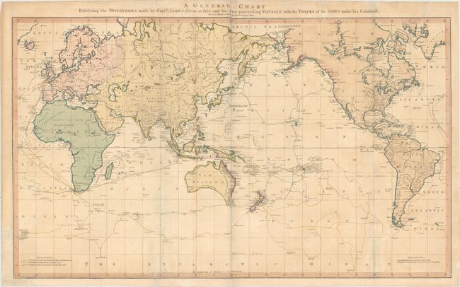
Captain James Cook (1728-1779) is best known for his three voyages to the Pacific (1768-71; 1772-75; and 1776-79). His discoveries radically changed the western understanding of the world in the late 18th century. He was the first to circumnavigate and chart New Zealand and provided the earliest European accounts of exploration along the eastern coast of Australia and the Hawaiian Islands. On February 14th, 1779, he was killed on Hawaii after attempting to kidnap the chief of the island.
Many contemporary accounts of Cook’s voyages, including charts and engravings, appeared in the late 18th century. The first official account of Cook’s first voyage was published in 1773 by John Hawkesworth in Volumes II and III of An Account of the Voyages Undertaken by the Order of His Present Majesty for Making Discoveries in the Southern Hemisphere... William Strahan and Thomas Cadell published the first official accounts of the second and third voyages in 1777 and 1784. Accounts of his exploration were subsequently translated into French, German, and Dutch.
This scarce, large map on Mercator's projection was compiled by Lieut. Henry Roberts from Cook's surveys after the third expedition. The map is centered on Australasia with the routes of the Endeavour (1768-71) and Resolution (1772-75 and 1776-80) illustrated with occasional notes along the tracks. Roberts began his compilation under Cook's supervision and completed it after Cook's death. An almost identical version of this map was first used in the official account of the third voyage, A Voyage to the Pacific Ocean in 1784 in an uncolored format. Soon thereafter, Faden published his own colored version including additional information. Faden uses color to distinguish the different tracks of Cook's voyages with a legend at bottom left. Color is also used along the coastlines surrounding the Pacific Ocean to identify areas discovered by the British (in red, although appearing pink in this example) and the Russians (in blue). Inland detail is confined to river systems and a few place names, although Robert Hearns' expedition through Canada is will depicted.
The colorful Faden edition is not only more attractive than the "official" Roberts edition, it is also much more scarce on the market.
References: Perry & Prescott 1800.04; cf. Wagner (NW) #699.
Condition: B
Full original color with a couple of extraneous creases and light toning and soiling. Issued folding with archival repairs to several short fold separations, a tear that enters 6" into map southwest of Australia, and a number of short tears along the edges of the sheet (4 of which enter the map image less than 1" at bottom). Remargined at bottom with a small portion of neatline replaced in facsimile.