Subject: Middle East
Period: 1578 (circa)
Publication: Speculum Orbis Terarrum
Color: Black & White
Size:
19.9 x 11.8 inches
50.5 x 30 cm
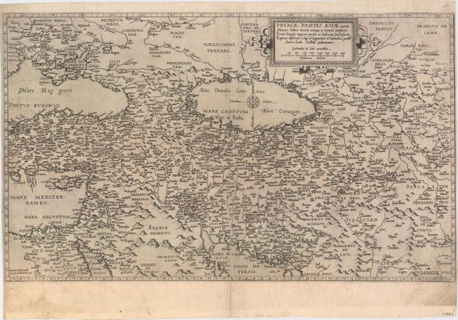
This handsome map of the Middle East is based on the work of Giacomo Gastaldi , and extends from the Black Sea and the eastern Mediterranean in the west, to Afghanistan and Pakistan in the east. Cyprus is prominently depicted in the Mediterranean, and the Caspian Sea is shown extending from east to west with a compass rose at center. The map was engraved by Lucas & Jan van Doeticum circa 1566 and was first published in 1578 in De Jode's Speculum Orbis Terrarum, with only one subsequent edition published in 1593 by his son Cornelis. Blank verso suggests this was an early printing.
Gerard de Jode published several important maps including Ortelius' famous 8-sheet map of the world in 1564. His major atlas, Speculum Orbis Terrarum was a commercial failure because his rival, Abraham Ortelius, was able to obtain a monopoly for eight years at the same time De Jode was preparing the publication. After Gerard's death, his widow and son enlarged the atlas and re-issued it in 1593. On the death of Cornelis, the copper plates were sold to J. B. Vrients, who acquired them merely to stop their re-issue, as he had also acquired the Ortelius plates. De Jode maps are rarely offered on the market.
References: Shirley (BL Atlases) T.JOD-1c; Van der Krogt (Vol. III) #8200:32.
Condition: B+
A dark impression on watermarked paper with archival repairs to a centerfold separation at bottom that extends 2" into the image and a short edge tear at left. Several towns are underlined in faint manuscript and there is minor soiling mostly in the blank margins.