Subject: Strait of Magellan
Period: 1694 (published)
Publication: An Account of Several Late Voyages
Color: Hand Color
Size:
20.6 x 16.4 inches
52.3 x 41.7 cm
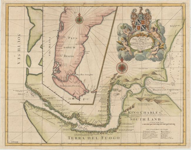
In 1670, John Narborough was the first Englishman to sail through the Strait of Magellan in both directions; thus demonstrating the falsity of the accepted wisdom that the wind and currents would prevent any eastward passage of the strait. He had been commissioned by James, Duke of York (later James II), to sail to South America to investigate potential trade possibilities. Narborough's expedition proved that a profitable trade with South America was possible, and this set the course of Britain's foreign policy for the next half century. Narborough first published his journal of the voyage in An Account of Several Late Voyages… in 1694, edited by Tancred Robinson and printed by Sam Smith and Benjamin Walford. The book included this map of the Strait of Magellan as well as a map of the region around the North Pole. Narborough's map provides a detailed view of the tortuous course of the strait with soundings and safe anchorages carefully noted. There are several notations along the coasts describing the countryside, and a lettered key at bottom right identifies numerous islands found within the strait. A large inset map shows Patagonia and Tierra del Fuego. The map is handsomely adorned with two large compass roses and a title cartouche held aloft by putti and supporting a dedication to Sam Pepys Esquire. Narborough's book was again republished in 1711, with the dedication cartouche on this map changed to Robert Earle of Oxford. Narborough's description of the Strait of Magellan provided the basis for British charts of the strait until the time of Captain Cook.
Both the original Narborough map and the Thornton re-issues are extremely scarce. We have only found one record of the first state of Narborough's map being on the market in the past 25 years.
References: Sabin #72185.
Condition: B+
Issued folding on watermarked paper, now pressed with minor creasing and attractive color. There is very minor soiling and archival repairs to a few short fold separations.