Showing Featured Lots(remove filter)
Filtered by Category:United States(Show All Categories)
Showing results for:Auction 143
Catalog Archive
20 lots
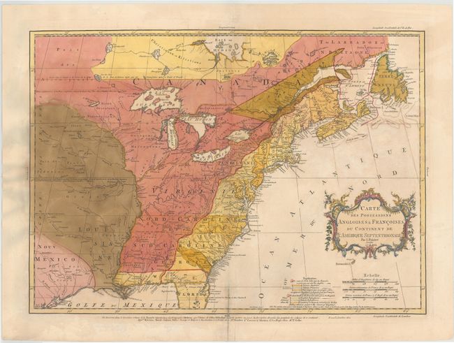
Auction 143, Lot 154
Subject: Colonial United States & Canada
Palairet, Jean
Carte des Possessions Angloises & Francoises du Continent de l'Amerique Septentrionale, 1756
Size: 22.5 x 16.7 inches (57.2 x 42.4 cm)
Estimate: $2,000 - $2,400
Sold for: $1,400
Closed on 2/13/2013
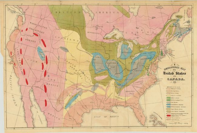
Auction 143, Lot 163
Subject: Canada & United States
Hitchcock, Edward
[Lot of 2] A Geological Map of the United States and Canada [and] Outline of the Geology of the Globe, 1853
Size: See Description
Estimate: $1,000 - $1,300
Sold for: $950
Closed on 2/13/2013
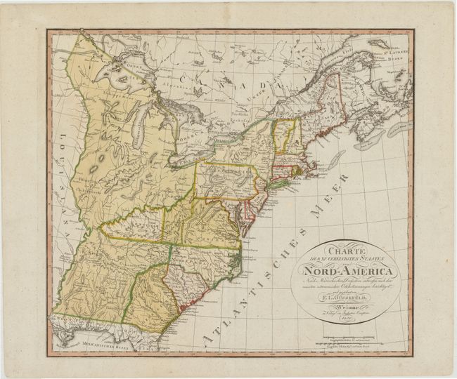
Auction 143, Lot 181
Subject: Eastern United States, Franklinia
Gussefeld, Franz Ludwig
Charte der XV Vereinigten Staaten von Nord-America…, 1800
Size: 20.5 x 18.3 inches (52.1 x 46.5 cm)
Estimate: $1,400 - $1,600
Map Depicting the Proposed State of Franklin
Sold for: $2,500
Closed on 2/13/2013
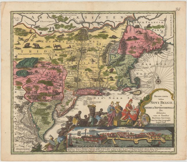
Auction 143, Lot 185
Subject: Colonial New England & Mid-Atlantic
Seutter, Matthias
Recens Edita totius Novi Belgii, in America Septentrionali siti, delineatio cura et Sumtibus, 1730
Size: 22.5 x 19.5 inches (57.2 x 49.5 cm)
Estimate: $4,000 - $4,750
Sold for: $3,250
Closed on 2/13/2013
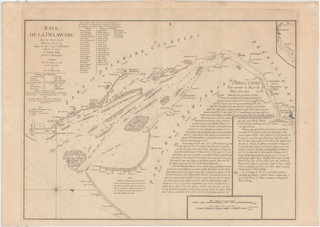
Auction 143, Lot 194
Subject: Colonial Mid-Atlantic, Delaware Bay
Le Rouge, George Louis
Baye de la Delaware avec les Ports, Sondes, Dangers, Bancs &c. depuis les Caps Jusqu'a Philadelphie…, 1777
Size: 25.8 x 19 inches (65.5 x 48.3 cm)
Estimate: $2,000 - $2,400
The Most Accurate Chart of Delaware Bay in the 18th Century
Unsold
Closed on 2/13/2013
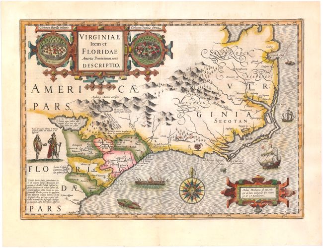
Auction 143, Lot 196
Subject: Colonial Southeast
Hondius, Jodocus
Virginiae Item et Floridae Americae Provinciarum, Nova Descriptio, 1628
Size: 19.1 x 13.5 inches (48.5 x 34.3 cm)
Estimate: $2,400 - $3,000
A Seminal Map of the Southeast and Early American Cartography
Sold for: $2,000
Closed on 2/13/2013
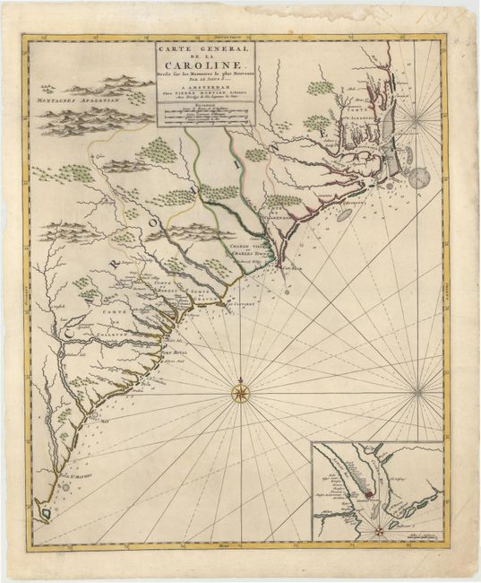
Auction 143, Lot 197
Subject: Colonial Southeast, North Carolina, South Carolina
Mortier, Pierre
Carte General de la Caroline Dresse sur les Memoires le Plus Nouveaux..., 1700
Size: 18.3 x 22.2 inches (46.5 x 56.4 cm)
Estimate: $3,250 - $4,000
Sold for: $2,100
Closed on 2/13/2013
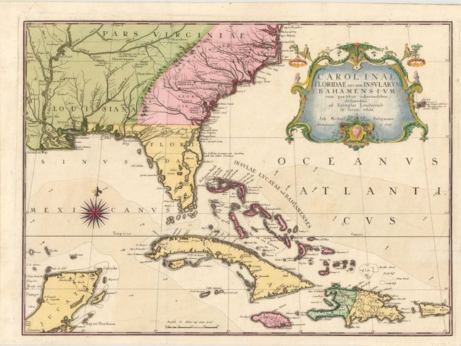
Auction 143, Lot 199
Subject: Colonial Southeast & Bahamas
Seligmann, Johann Michael
Carolinae Floridae nec non Insularum Bahamensium…, 1755
Size: 23 x 16.8 inches (58.4 x 42.7 cm)
Estimate: $5,500 - $6,500
Very Scarce and Important Map of the Southeastern United States
Sold for: $3,750
Closed on 2/13/2013
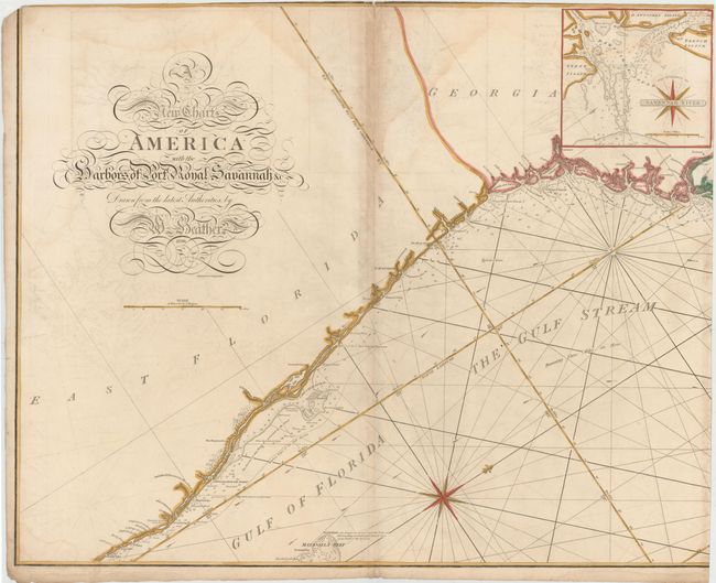
Auction 143, Lot 201
Subject: Southeast United States
Heather, William
[On 2 Sheets] A New Chart of America with the Harbors of Port Royal, Savannah &c, 1799
Size: 30.5 x 24.7 inches (77.5 x 62.7 cm)
Estimate: $4,000 - $6,000
A Remarkable Sea Chart of the Southeastern Coast
Sold for: $3,000
Closed on 2/13/2013
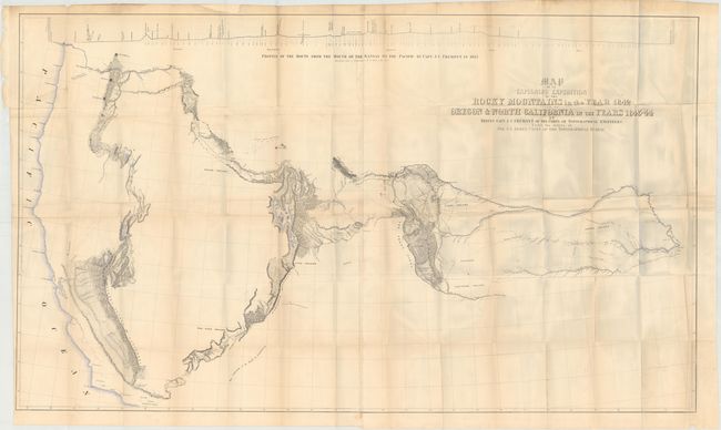
Auction 143, Lot 216
Subject: Western United States
Fremont/Preuss
[Lot of 2] Map of an Exploring Expedition to the Rocky Mountains in the Year 1842 and to Oregon & North California in the Years 1843-44 [and] Report of The Exploring Expedition to the Rocky Mountains…, 1845
Size: 51 x 30.5 inches (129.5 x 77.5 cm)
Estimate: $2,300 - $2,750
Sold for: $1,300
Closed on 2/13/2013
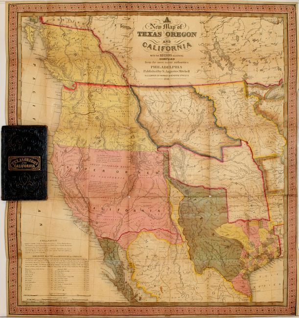
Auction 143, Lot 218
Subject: Western United States
Mitchell, Samuel Augustus
A New Map of Texas Oregon and California, 1846
Size: 19 x 21 inches (48.3 x 53.3 cm)
Estimate: $9,000 - $11,000
Mitchell's Famous Map Showing the New State of Texas
Sold for: $6,500
Closed on 2/13/2013
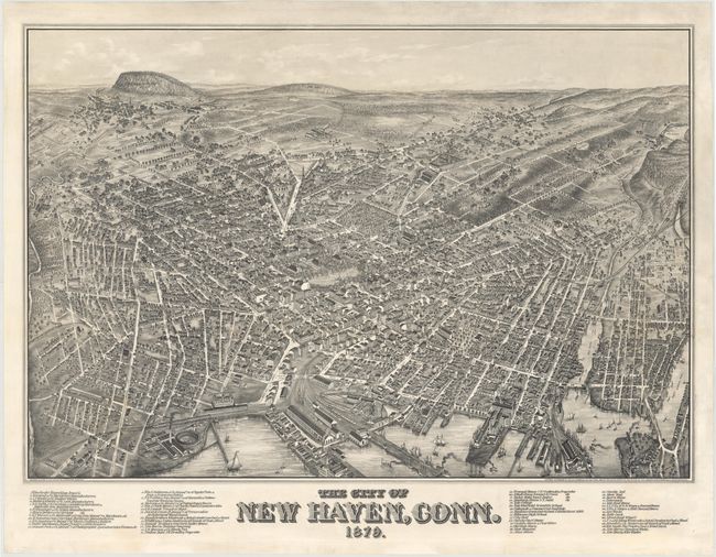
Auction 143, Lot 231
Subject: New Haven, Connecticut
Bailey, O. H. & Co.
The City of New Haven, Conn. 1879., 1879
Size: 37.4 x 25.7 inches (95 x 65.3 cm)
Estimate: $8,000 - $9,000
Extremely Rare View of New Haven and Yale College
Unsold
Closed on 2/13/2013
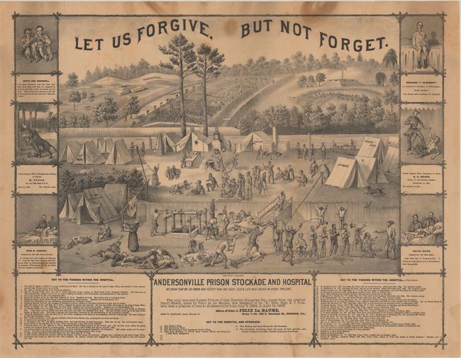
Auction 143, Lot 239
Subject: Georgia, Civil War
Andersonville Prison Stockade and Hospital, 1870
Size: 25.5 x 19.5 inches (64.8 x 49.5 cm)
Estimate: $300 - $400
Fascinating Civil War Scene
Sold for: $250
Closed on 2/13/2013
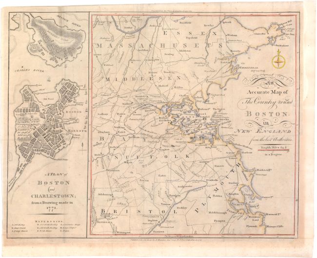
Auction 143, Lot 260
Subject: Boston, Massachusetts
Anon.
An Accurate Map of The Country round Boston in New England from the best Authorities [on sheet with] A Plan of Boston and Charlestown; from a Drawing made on 1771, 1776
Size: 16.3 x 12.3 inches (41.4 x 31.2 cm)
Estimate: $1,100 - $1,400
Uncommon Revolutionary War Map
Sold for: $550
Closed on 2/13/2013
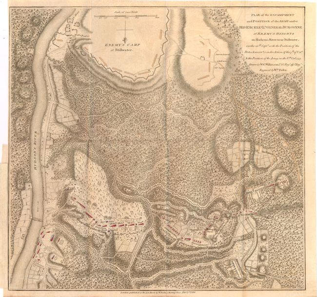
Auction 143, Lot 270
Subject: Colonial New York, Revolutionary War
Faden, William
Plan of the Encampment and Position of the Army under his Excelly. Lt. General Burgoyne at Braemus Heights on Hudson's River near Stillwater..., 1780
Size: 13.9 x 13.3 inches (35.3 x 33.8 cm)
Estimate: $1,400 - $1,700
Important Revolutionary War Map
Sold for: $700
Closed on 2/13/2013
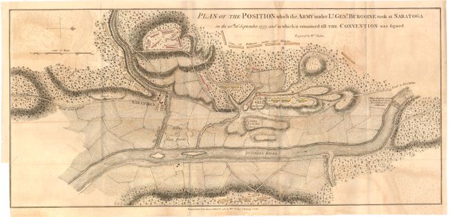
Auction 143, Lot 271
Subject: Colonial New York, Revolutionary War
Faden, William
Plan of the Position which the Army under Lt. Genl. Burgoine Took at Saratoga on the 10th of September 1777..., 1780
Size: 18.8 x 8.5 inches (47.8 x 21.6 cm)
Estimate: $1,500 - $1,800
Important Revolutionary War Map
Sold for: $1,100
Closed on 2/13/2013
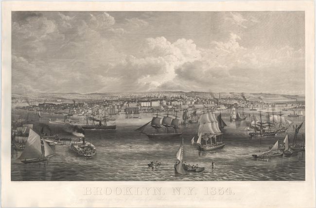
Auction 143, Lot 278
Subject: Brooklyn, New York
Brooklyn. N.Y. 1854, 1854
Size: 41 x 23.8 inches (104.1 x 60.5 cm)
Estimate: $6,000 - $7,000
Rare, Early View of Brooklyn
Sold for: $3,250
Closed on 2/13/2013
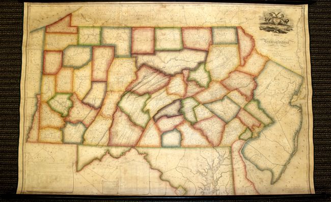
Auction 143, Lot 285
Subject: Pennsylvania
Melish, John
Map of Pennsylvania, Constructed from the County Surveys Authorized by the State; and other Original Documents...Corrected & Improved to 1826, 1826
Size: 73.5 x 42.5 inches (186.7 x 108 cm)
Estimate: $13,500 - $15,000
Melish's Greatest Published Work
Unsold
Closed on 2/13/2013
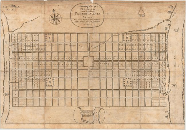
Auction 143, Lot 287
Subject: Philadelphia, Pennsylvania
Holme, Thomas
A Portraiture of the City of Philadelphia in the Province of Pennsylvania in America [with] Ordinances of the Corporation of the City of Philadelphia…, 1812
Size: 5.6 x 9 inches (14.2 x 22.9 cm)
Estimate: $4,000 - $5,000
One of the Most Important Plans of a Colonial North American City
Sold for: $2,100
Closed on 2/13/2013
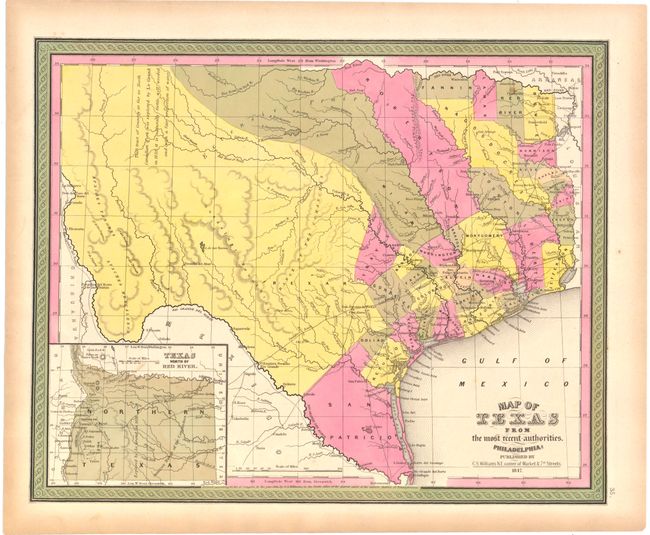
Auction 143, Lot 291
Subject: Texas
Williams, C. S.
Map of Texas from the Most Recent Authorities, 1847
Size: 14.5 x 12 inches (36.8 x 30.5 cm)
Estimate: $1,000 - $1,300
Sold for: $750
Closed on 2/13/2013
20 lots