Subject: Southeast United States
Period: 1799 (dated)
Publication: The Marine Atlas Or Seaman's Complete Pilot
Color: Hand Color
Size:
30.5 x 24.7 inches
77.5 x 62.7 cm
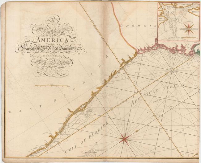
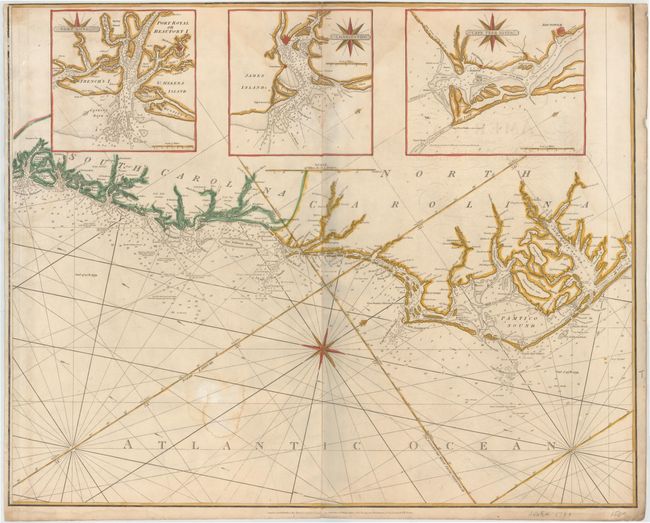
This is a scarce, large-scale chart of the coast from just north of Palm Beach, Florida to the Albemarle Sound and Outer Banks in North Carolina. There is excellent detail of coastal islands, river inlets, soundings, anchorages, and shoals, and numerous place names are given along the coast. The direction of the Gulf Stream is marked, along with the note: Running Three Miles an Hour. Four large insets fill the blank inland area with detailed, enlarged charts of important sounds and river inlets: Savannah River, Port Royal Sound, Charleston Harbor, and Cape Fear River. There are numerous short notes throughout the chart regarding the sand, shells, and navigational hazards in the coastal waters. Engraved by J. Stephenson. Size is for each sheet; if joined, the map would measure 60.7 x 24.7".
At the end of the 18th century Britain played a leading role in chart making and William Heather was among the most prominent cartographers of the period. He succeeded Mount and Page in 1765 and then established a Naval Academy and the Naval Warehouse, which provided nautical instruments, charts and instructional texts on navigation. Heather later changed the name of his publishing company to "Heather & Williams" (as seen in the imprint on this chart). This name remained until John William Norie, who began his career working for Heather, took over the company after Heather's retirement and renamed it the J.W. Norie and Company in 1813.
References: Phillips (Atlases) #2850 [47].
Condition: B
There is some soiling, light offsetting, and several large but light damp stains. There are a few tiny tears confined to blank margins, and a 1" centerfold separation at top of southern sheet that has been closed on verso with archival tape. Both sheets with no top margins, as issued, and some loss of neatline. The southern sheet has been trimmed at right to prepare the maps for joining.