Subject: Boston, Massachusetts
Period: 1776 (dated)
Publication: Town & Country Magazine,
Color: Hand Color
Size:
16.3 x 12.3 inches
41.4 x 31.2 cm
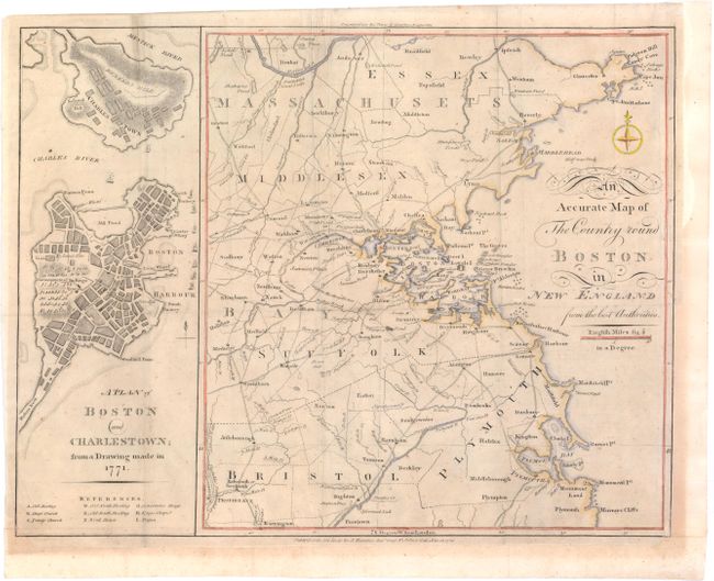
Made for the January 16th, 1776 edition of Town & Country Magazine, with two maps shown on a single sheet. The map on the left was based on a 1771 drawing of the city just after the Boston Massacre of 1770, and it shows Boston and Charlestown with the major streets and buildings named, including Faneuil Hall. An encampment of Redcoats are shown right next to a small depiction of the Liberty Tree. The Liberty Tree was an elm tree located at about Washington and Essex streets and used as a meeting place by the Sons of Liberty, who formed after the Stamp Act of 1765. The tree was attacked by British Loyalists in 1775 and burned, but remained a popular symbol, encouraging other colonialists to erect Liberty poles, hung with flags depicting the Liberty Tree. The second map shows the surrounding countryside from Ipswich, Gloucester and Cape Ann down to Plymouth, and as far west as Providence and Groton. A fascinating map from the birth of the United States.
References: Jolly TOWN-2; Sellers & Van Ee #894; Nebenzahl (Biblio) #14 & 14a.
Condition: B
Issued folding and now pressed, the lower margin and right margin have been extended with old paper to better accommodate framing, also repairing a chip in bottom left corner with neatline replaced in facsimile. There is light toning and one small wormhole at upper left.