Filtered by Category:Canada(Show All Categories)
Showing results for:Auction 169
Catalog Archive
34 lots
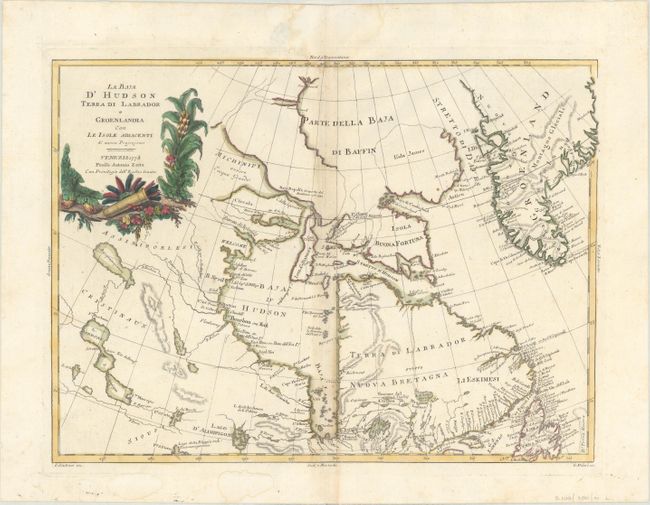
Auction 169, Lot 115
Subject: Canada & Greenland
Zatta, Antonio
La Baja d'Hudson Terra di Labrador e Groenlandia con le Isole Adiacenti di Nuova Projezione, 1778
Size: 16.2 x 11.9 inches (41.1 x 30.2 cm)
Estimate: $200 - $230
Sold for: $120
Closed on 9/12/2018
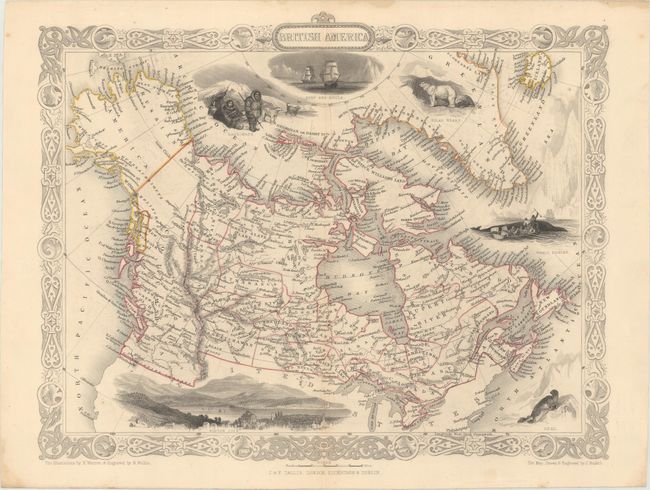
Auction 169, Lot 116
Subject: Canada
Tallis, John
British America, 1851
Size: 12.9 x 10.1 inches (32.8 x 25.7 cm)
Estimate: $130 - $160
Sold for: $80
Closed on 9/12/2018
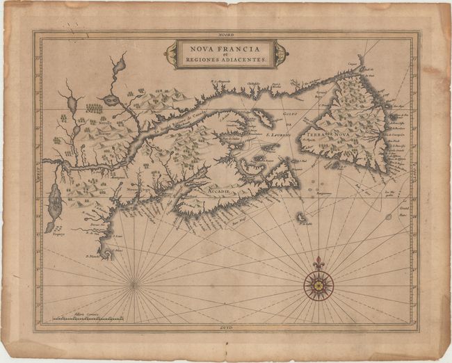
Auction 169, Lot 117
Subject: Eastern Canada
de Laet, Joannes
Nova Francia et Regiones Adiacentes, 1630
Size: 14 x 11.1 inches (35.6 x 28.2 cm)
Estimate: $600 - $750
Sold for: $1,300
Closed on 9/12/2018
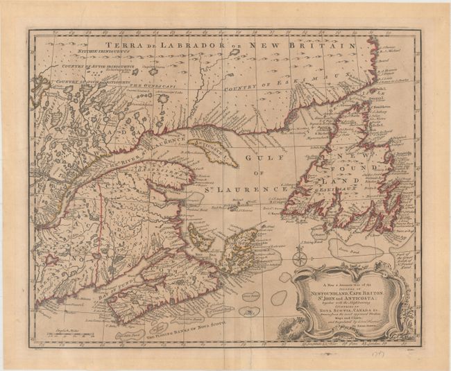
Auction 169, Lot 118
Subject: Eastern Canada
Bowen, Emanuel
A New & Accurate Map of the Islands of Newfoundland, Cape Briton, St. John and Anticosta; Together with the Neighbouring Countries of Nova Scotia, Canada &c..., 1747
Size: 16.8 x 13.7 inches (42.7 x 34.8 cm)
Estimate: $240 - $300
Sold for: $190
Closed on 9/12/2018
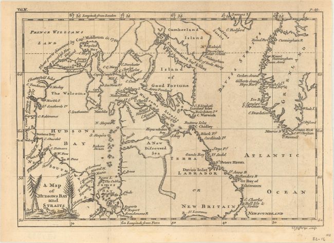
Auction 169, Lot 119
Subject: Eastern Canada, Greenland
Jefferys, Thomas
A Map of Hudsons Bay and Straits, 1756
Size: 8.3 x 5.8 inches (21.1 x 14.7 cm)
Estimate: $120 - $150
Sold for: $90
Closed on 9/12/2018
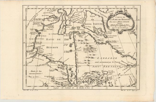
Auction 169, Lot 120
Subject: Eastern Canada
Bellin, Jacques Nicolas
[Lot of 3] Carte de la Baye de Hudson, pour Servir a l'Histoire General des Voyages [and] Carte de l'Acadie, Isle Royale, et Pais Voisins... [and] Carte du Golphe de St. Laurent et Pays Voisins..., 1757
Size: See Description
Estimate: $220 - $250
Sold for: $90
Closed on 9/12/2018
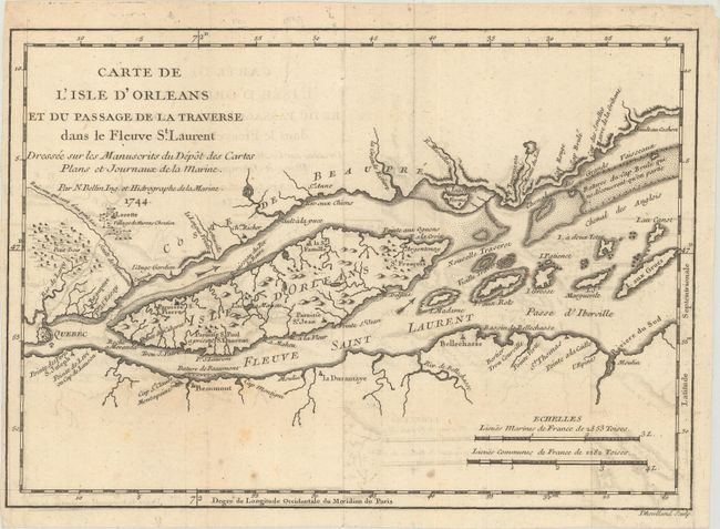
Auction 169, Lot 121
Subject: St. Lawrence River, Canada
Bellin, Jacques Nicolas
Carte de l'Isle d'Orleans et du Passage de la Traverse dans le Fleuve St. Laurent Dressee sur les Manuscrits du Depot des Cartes Plans et Journaux de la Marine, 1744
Size: 10.8 x 7.6 inches (27.4 x 19.3 cm)
Estimate: $110 - $140
NO RESERVE
Sold for: $55
Closed on 9/12/2018
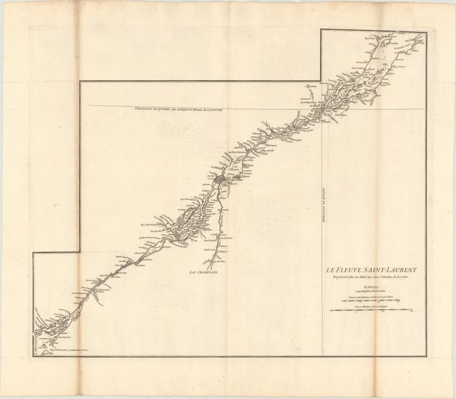
Auction 169, Lot 122
Subject: St. Lawrence River, Canada
[Lot of 2] Le Fleuve Saint-Laurent Represente Plus en Detail que dans l'Etendue de la Carte [and] The River St. Lawrence, Accurately Drawn from D'Anville's Map Publish'd Under the Patronage of the Duke of Orleans, 1755-84
Size: See Description
Estimate: $350 - $425
Unsold
Closed on 9/12/2018
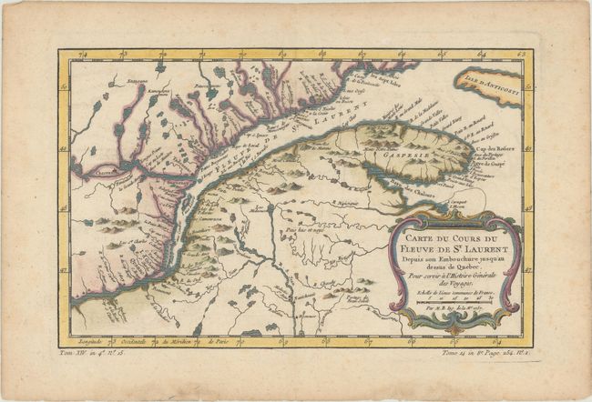
Auction 169, Lot 123
Subject: St. Lawrence River, Canada
Bellin, Jacques Nicolas
Carte du Cours du Fleuve de St. Laurent Depuis son Embouchure Jusqu'au Dessus de Quebec. Pour Servir a l'Histoire Generale des Voyages, 1757
Size: 11.8 x 7.5 inches (30 x 19.1 cm)
Estimate: $110 - $140
Sold for: $80
Closed on 9/12/2018
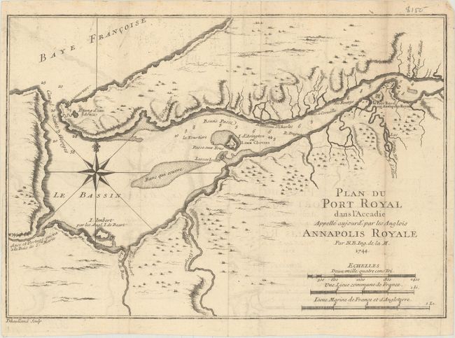
Auction 169, Lot 124
Subject: Nova Scotia, Canada
Bellin, Jacques Nicolas
Plan du Port Royal dans l'Accadie Appelle Aujourd' par les Anglois Annapolis Royale, 1744
Size: 11.1 x 7.6 inches (28.2 x 19.3 cm)
Estimate: $90 - $120
NO RESERVE
Sold for: $120
Closed on 9/12/2018
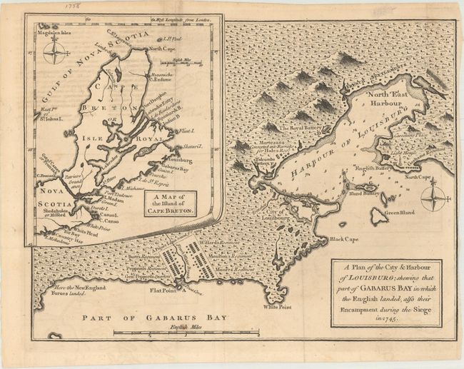
Auction 169, Lot 125
Subject: Nova Scotia, Canada
Anon.
A Plan of the City & Harbour of Louisburg; Shewing That Part of Gabarus Bay in Which the English Landed, Also Their Encampment During the Siege in 1745, 1758
Size: 10.1 x 7.6 inches (25.7 x 19.3 cm)
Estimate: $110 - $140
NO RESERVE
Sold for: $110
Closed on 9/12/2018
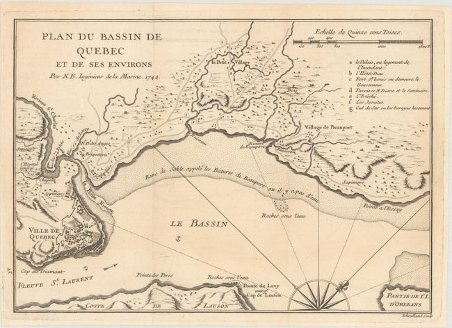
Auction 169, Lot 126
Subject: Quebec City, Canada
Bellin, Jacques Nicolas
Plan du Bassin de Quebec et de Ses Environs, 1744
Size: 11 x 7.8 inches (27.9 x 19.8 cm)
Estimate: $120 - $150
Sold for: $90
Closed on 9/12/2018
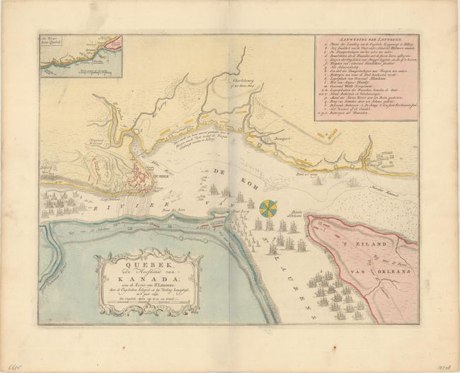
Auction 169, Lot 127
Subject: Quebec City, Canada
Tirion, Isaac
Quebek, de Hoofdstad van Kanada; aan de Rivier van St. Laurens: door de Engelschen Belegerd en by Verdrag Bemagtigd, in 't Jaar 1759, 1759
Size: 16.8 x 12.8 inches (42.7 x 32.5 cm)
Estimate: $275 - $350
Sold for: $200
Closed on 9/12/2018
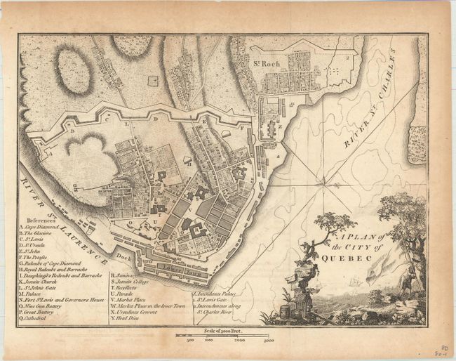
Auction 169, Lot 128
Subject: Quebec City, Canada
Weld, Isaac
A Plan of the City of Quebec, 1798
Size: 9.4 x 6.8 inches (23.9 x 17.3 cm)
Estimate: $160 - $190
Sold for: $65
Closed on 9/12/2018
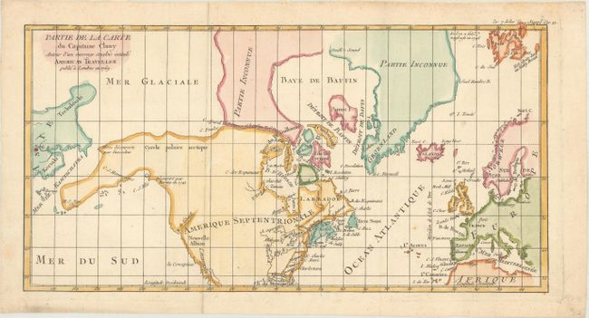
Auction 169, Lot 129
Subject: Colonial United States, Canada & Arctic
Robert de Vaugondy, Didier
Partie de la Carte du Capitaine Cluny Auteur d'un Ouvrage Anglois Intitule American Traveller Publie a Londres en 1769, 1772
Size: 16.3 x 8.4 inches (41.4 x 21.3 cm)
Estimate: $140 - $170
Sold for: $100
Closed on 9/12/2018
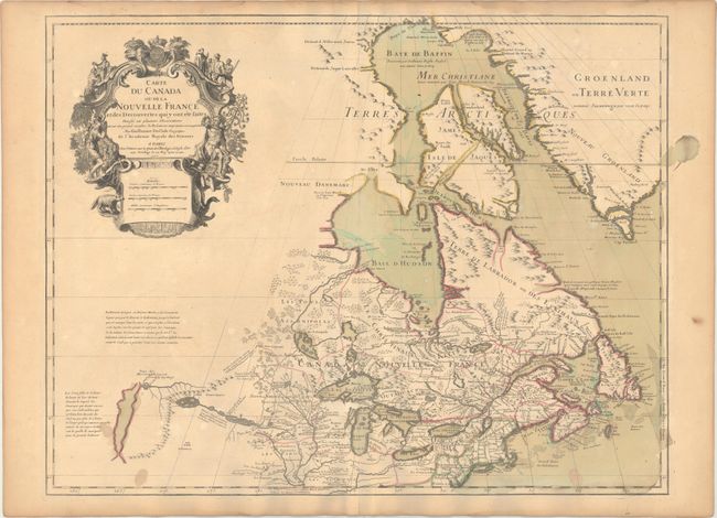
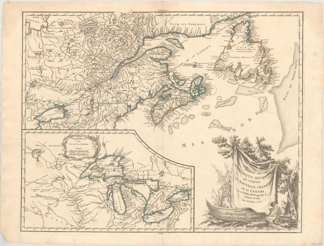
Auction 169, Lot 130
Subject: Colonial Northeastern United States & Canada, Great Lakes
Delisle, Guillaume
Carte du Canada ou de la Nouvelle France et des Decouvertes qui y ont ete Faites..., 1703
Size: 25.6 x 19.6 inches (65 x 49.8 cm)
Estimate: $2,200 - $2,500
Delisle's Seminal Map of Canada and the Great Lakes
Sold for: $1,600
Closed on 9/12/2018
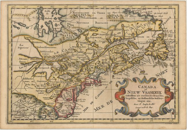
Auction 169, Lot 131
Subject: Colonial Northeastern United States & Canada, Great Lakes
Sanson, Nicolas
Canada of Niew Vrankryk Getrokken uit Verscheide Fransche, Engelsche, en Hollandsche Beschryvingen Enz., 1705
Size: 11.9 x 8.2 inches (30.2 x 20.8 cm)
Estimate: $600 - $750
Small Version of a Keystone Map for Great Lakes Collections
Sold for: $425
Closed on 9/12/2018
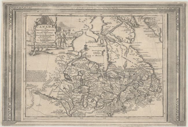
Auction 169, Lot 132
Subject: Colonial Northeastern United States & Canada
Aa, Pieter van der
Canada ou Nouvelle France, Suivant les Nouvelles Observations de Messrs. de l'Academie Royale des Sciences, Etc. Augmentees de Nouveau, 1730
Size: 15.1 x 10.3 inches (38.4 x 26.2 cm)
Estimate: $450 - $550
Picture-Frame Style Border
Sold for: $325
Closed on 9/12/2018
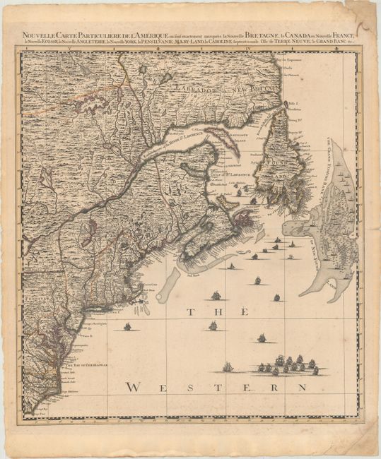
Auction 169, Lot 133
Subject: Colonial Northeastern United States & Canada
Popple/Covens & Mortier
Nouvelle Carte Particuliere de l'Amerique ou sont Exactement Marquees la Nouvelle Bretagne, le Canada ou Nouvelle France, la Nouvelle Ecosse, la Nouvelle Angleterre, la Nouvelle York..., 1741
Size: 20.5 x 22.4 inches (52.1 x 56.9 cm)
Estimate: $2,400 - $3,000
The Northeastern Sheet of the Reduced-Size Edition of Popple's Map
Unsold
Closed on 9/12/2018
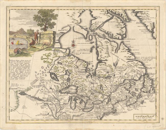
Auction 169, Lot 134
Subject: Colonial Northeastern United States & Canada, Great Lakes
Albrizzi, Girolamo
Carta Geografica del Canada nell' America Settentrionale, 1742
Size: 17 x 13 inches (43.2 x 33 cm)
Estimate: $800 - $950
Sold for: $650
Closed on 9/12/2018
Auction 169, Lot 135
Subject: Colonial Northeastern United States & Canada, Great Lakes
Robert de Vaugondy, Didier
Partie de l'Amerique Septent? qui Comprend la Nouvelle France ou le Canada, 1755
Size: 23.9 x 19 inches (60.7 x 48.3 cm)
Estimate: $600 - $750
Sold for: $450
Closed on 9/12/2018
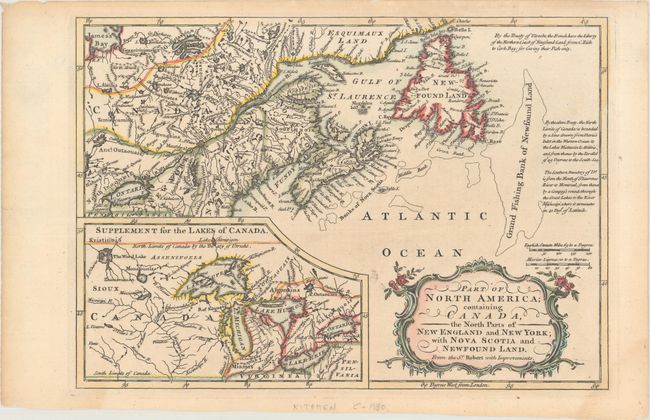
Auction 169, Lot 136
Subject: Colonial Northeastern United States & Canada, Great Lakes
Barrow, John (Sir)
Part of North America; Containing Canada, the North Parts of New England and New York; with Nova Scotia and Newfound Land..., 1759
Size: 11.6 x 8.1 inches (29.5 x 20.6 cm)
Estimate: $160 - $190
Sold for: $120
Closed on 9/12/2018
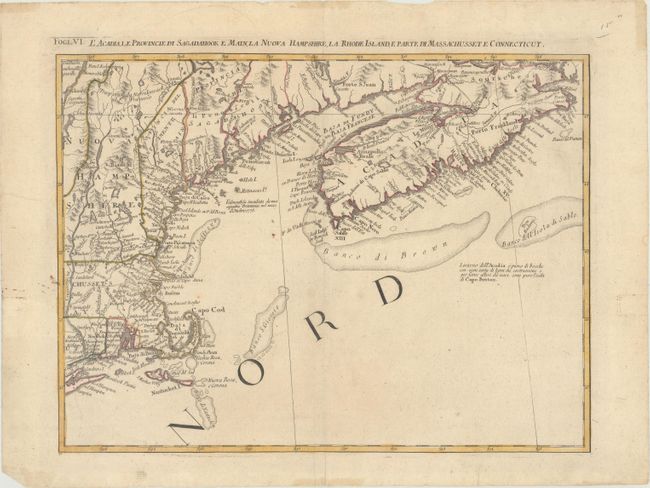
Auction 169, Lot 137
Subject: Colonial Northeastern United States & Canada
Zatta, Antonio
L'Acadia, le Provincie di Sagadahook e Main, la Nuova Hampshire, la Rhode Island, e Parte di Massachusset e Connecticut, 1778
Size: 16.6 x 12.5 inches (42.2 x 31.8 cm)
Estimate: $240 - $300
Sold for: $180
Closed on 9/12/2018
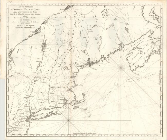
Auction 169, Lot 138
Subject: Northeastern United States & Canada
Carte Reduite du Nord des Etats-Unis avec l'Interieur du Pays. Pour Servir a Intelligence de Cette Histoire..., 1830
Size: 22.9 x 19.6 inches (58.2 x 49.8 cm)
Estimate: $375 - $450
Unsold
Closed on 9/12/2018
Auction 169, Lot 139
Subject: Colonial Eastern United States & Canada
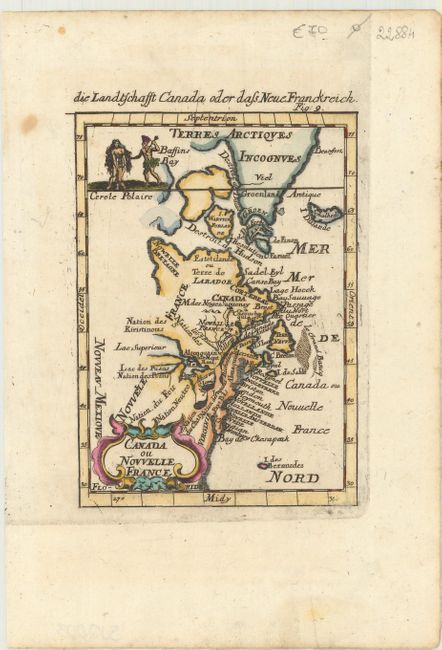
Mallet, Alain Manesson
Canada ou Nouvelle France, 1684
Size: 3.9 x 5.5 inches (9.9 x 14 cm)
Estimate: $200 - $230
Sold for: $200
Closed on 9/12/2018
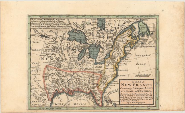
Auction 169, Lot 140
Subject: Colonial Eastern United States & Canada
Moll, Herman
A Map of New France Containing Canada, Louisiana &c. in Nth. America. According to the Patent Granted by the King of France to Monsieur Crozat..., 1717
Size: 10.1 x 7.3 inches (25.7 x 18.5 cm)
Estimate: $475 - $600
Sold for: $400
Closed on 9/12/2018
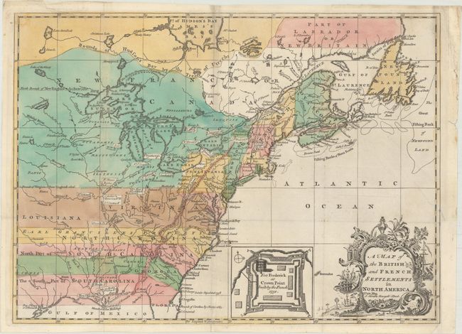
Auction 169, Lot 141
Subject: Colonial Eastern United States & Canada
Hinton, John
A Map of the British and French Settlements in North America, 1755
Size: 14.9 x 10.9 inches (37.8 x 27.7 cm)
Estimate: $800 - $950
Sold for: $750
Closed on 9/12/2018
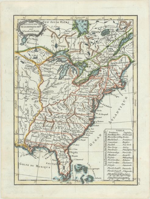
Auction 169, Lot 142
Subject: Eastern United States & Canada
Lattre, Jean
Etats-Unis de l'Amerique Seple. avec le Canada et la Floride, 1790
Size: 7.2 x 9.8 inches (18.3 x 24.9 cm)
Estimate: $200 - $230
Sold for: $180
Closed on 9/12/2018
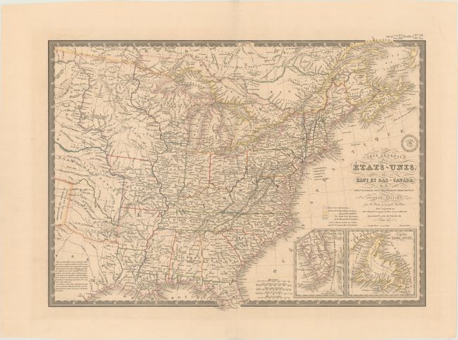
Auction 169, Lot 143
Subject: Eastern United States & Canada, Texas
Brue, Adrien Hubert
Carte Generale des Etats-Unis, des Haut et Bas-Canada, de la Nouvle. Ecosse, du Nouvau. Brunswick, de Terre-Neuve, &a. Seconde Edition, 1843
Size: 20.3 x 14.5 inches (51.6 x 36.8 cm)
Estimate: $180 - $220
Sold for: $110
Closed on 9/12/2018
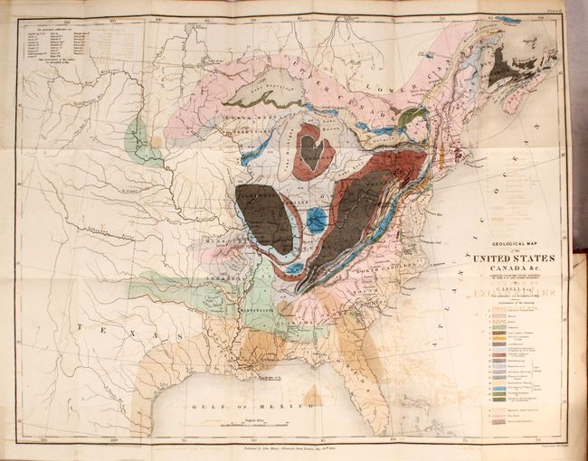
Auction 169, Lot 144
Subject: Eastern United States & Canada
Lyell, Charles
Geological Map of the United States Canada &c. [bound in] Travels in North America; with Geological Observations on the United States, Canada, and Nova Scotia, 1845
Size: 4.9 x 7.9 inches (12.4 x 20.1 cm)
Estimate: $650 - $800
London Edition of Lyell's Important Account & Geological Map
Sold for: $450
Closed on 9/12/2018
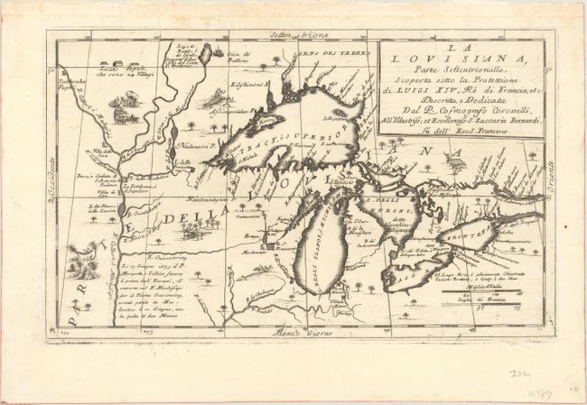
Auction 169, Lot 145
Subject: Colonial Central United States & Canada, Great Lakes
Coronelli, Vincenzo Maria
La Louisiana, Parte Settentrionalle, Scoperta Sotto la Protettione di Luigi XIV, Re di Francia, Etc., 1695
Size: 16.6 x 10.1 inches (42.2 x 25.7 cm)
Estimate: $3,500 - $4,250
Coronelli's Important Map of the Great Lakes & Upper Mississippi River Valley
Sold for: $4,000
Closed on 9/12/2018
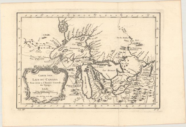
Auction 169, Lot 146
Subject: Colonial Central United States & Canada, Great Lakes
Bellin, Jacques Nicolas
Carte des Lacs du Canada pour Servir a l'Histoire Generale des Voyages, 1757
Size: 11.5 x 7.7 inches (29.2 x 19.6 cm)
Estimate: $400 - $475
Sold for: $325
Closed on 9/12/2018
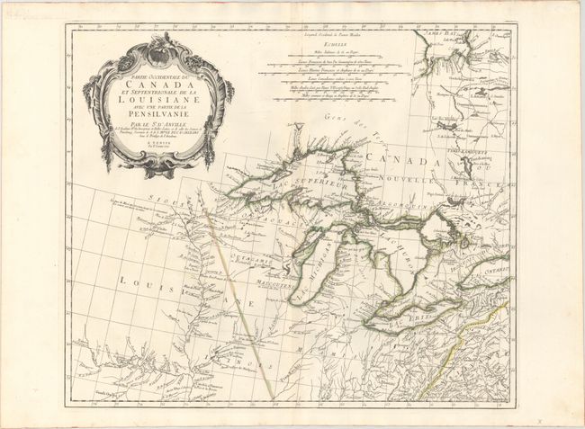
Auction 169, Lot 147
Subject: Colonial Central United States & Canada, Great Lakes
D'Anville/Santini
Partie Occidentale du Canada et Septentrionale de la Louisiane avec une Partie de la Pensilvanie, 1775
Size: 22.3 x 18.9 inches (56.6 x 48 cm)
Estimate: $800 - $950
Sold for: $650
Closed on 9/12/2018
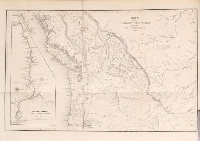
Auction 169, Lot 148
Subject: Northwestern United States & Canada
Wilkes, Charles
Map of the Oregon Territory from the Best Authorities [bound in] Astoria or, Anecdotes of an Enterprise Beyond the Rocky Mountains, 1851
Size: 13.1 x 8.3 inches (33.3 x 21.1 cm)
Estimate: $160 - $190
Sold for: $120
Closed on 9/12/2018
34 lots