Subject: Colonial Northeastern United States & Canada
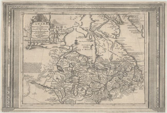
Period: 1730 (circa)
Publication: Le Nouveau Theatre du Monde ou la Geographie Royale
Color: Black & White
Size:
15.1 x 10.3 inches
38.4 x 26.2 cm
Beautifully engraved map of northeastern North American and the Great Lakes region based on Delisle's important map of 1703. The Great Lakes are reasonably well delineated, but Hudson Bay and the upper Mississippi River basin are distorted. Lahontan's mythical Riviere Longue is shown linking a large western lake with the Mississippi River. It is thought that the lake's origin is derived from Indian stories concerning the Great Salt Lake. The map is filled with place names, Indian tribes and interesting notations. The large title cartouche is surrounded by scenes of natives and indigenous animals. This is the much more decorative, and uncommon, third state with the map enclosed in a superb picture frame-style border with incredible 3-dimensional quality. The plate in this edition was issued with a map of Florida on the same sheet.
References: Kershaw #329.
Condition: B
A dark, but somewhat uneven impression in the top half of the image. There is a professionally infilled 1.5" worm track to the left of the title cartouche, and the bottom decorative border has been slightly trimmed as the sheet had two maps on it and then it was cut by the binder for inclusion in the atlas.