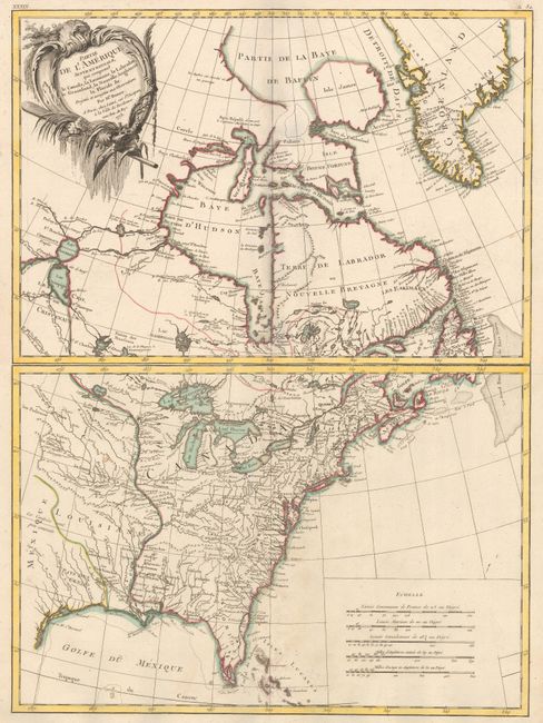
Filtered by Category:Canada(Show All Categories)
Showing results for:Auction 156
Catalog Archive
36 lots
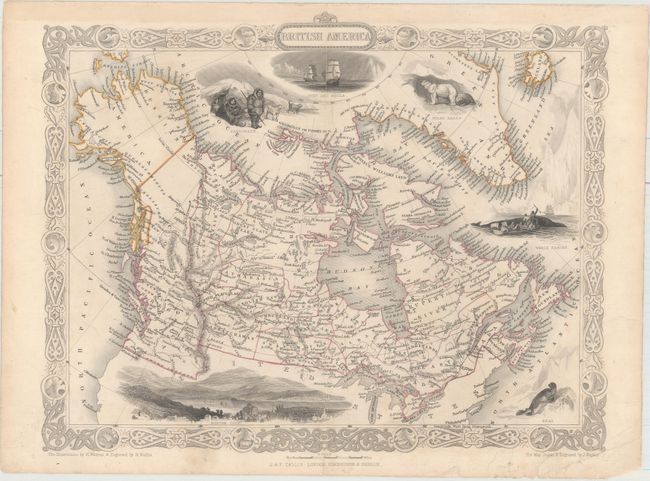
Auction 156, Lot 106
Subject: Canada, Alaska
Tallis, John
British America, 1850
Size: 12.9 x 10.1 inches (32.8 x 25.7 cm)
Estimate: $200 - $250
Sold for: $95
Closed on 2/17/2016
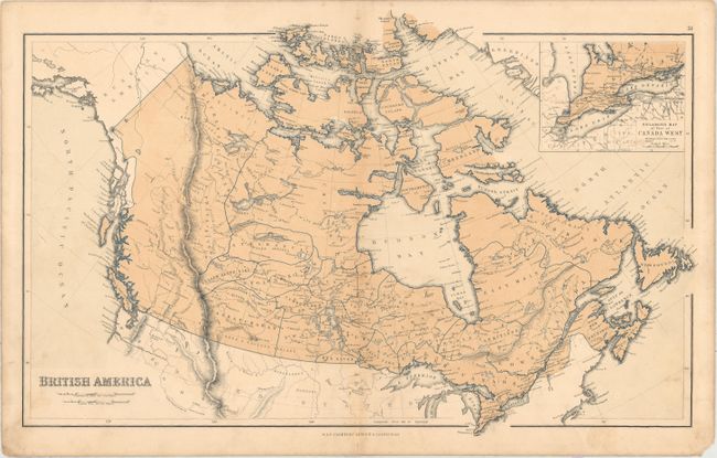
Auction 156, Lot 107
Subject: Canada
Chambers, William & Robert
British America, 1855
Size: 18.3 x 11.7 inches (46.5 x 29.7 cm)
Estimate: $40 - $55
NO RESERVE
Sold for: $85
Closed on 2/17/2016
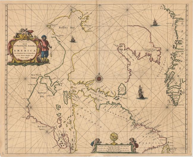
Auction 156, Lot 108
Subject: Eastern Canada and Greenland
Goos, Pieter
Paskaert Zynde de Noordelijckste Zeekusten van America van Groenland door de Straet Davis en de Straet Hudson tot Terra Neuf, 1666
Size: 21.4 x 17.5 inches (54.4 x 44.5 cm)
Estimate: $950 - $1,200
Goos' Uncommon Sea Chart Centered on Hudson Strait
Unsold
Closed on 2/17/2016

Auction 156, Lot 109
Subject: Eastern Canada, Newfoundland
Mallet, Alain Manesson
Isle de Terre Neuve, 1683
Size: 4.2 x 5.8 inches (10.7 x 14.7 cm)
Estimate: $180 - $210
Sold for: $130
Closed on 2/17/2016
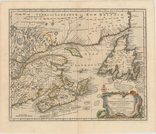
Auction 156, Lot 110
Subject: Eastern Canada
Bowen, Emanuel
A New & Accurate Map of the Islands of Newfoundland, Cape Briton, St. John and Anticosta; Together with the Neighbouring Countries of Nova Scotia, Canada &c..., 1752
Size: 16.7 x 13.6 inches (42.4 x 34.5 cm)
Estimate: $375 - $450
Sold for: $275
Closed on 2/17/2016
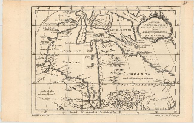
Auction 156, Lot 111
Subject: Eastern Canada, Hudson Bay
Bellin, Jacques Nicolas
Carte de la Baye de Hudson, pour Servir a l'Histoire Generale des Voyages, 1757
Size: 12 x 8.8 inches (30.5 x 22.4 cm)
Estimate: $100 - $130
Sold for: $75
Closed on 2/17/2016
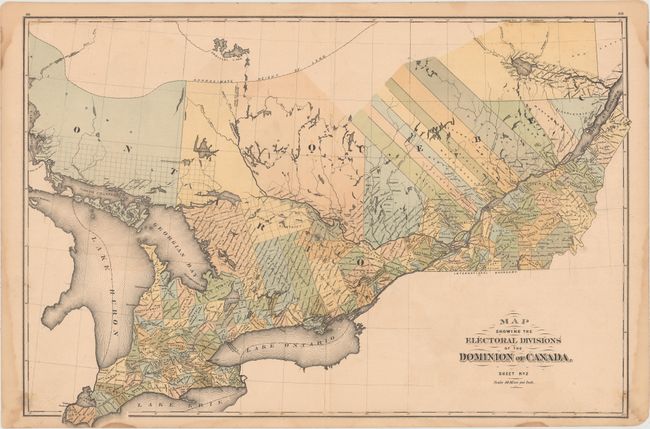
Auction 156, Lot 112
Subject: Eastern Canada
Map Showing the Electoral Divisions of the Dominion of Canada. Sheet No. 2, 1881
Size: 24.9 x 16.9 inches (63.2 x 42.9 cm)
Estimate: $50 - $65
NO RESERVE
Sold for: $34
Closed on 2/17/2016
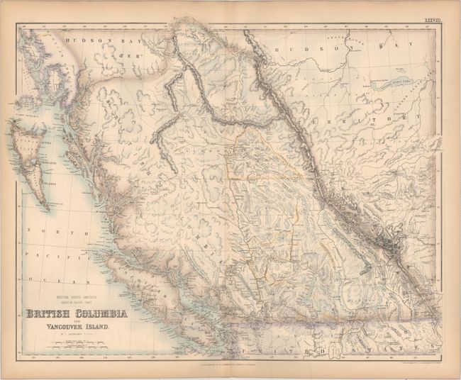
Auction 156, Lot 113
Subject: Western Canada
Fullarton, Archibald & Co.
British North America Sheet III. Pacific Coast. British Columbia and Vancouver Island, 1872
Size: 21.8 x 17.1 inches (55.4 x 43.4 cm)
Estimate: $100 - $130
Sold for: $75
Closed on 2/17/2016
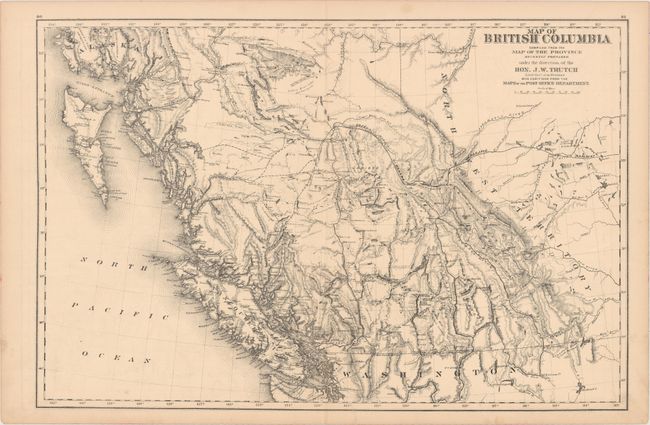
Auction 156, Lot 114
Subject: Western Canada
Map of British Columbia Compiled from the Map of the Province Recently Prepared Under the Direction of the Hon. J.W. Trutch..., 1878
Size: 24.2 x 16.1 inches (61.5 x 40.9 cm)
Estimate: $275 - $350
NO RESERVE
Unsold
Closed on 2/17/2016
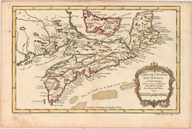
Auction 156, Lot 115
Subject: Nova Scotia, Canada
Bellin, Jacques Nicolas
Carte de l'Acadie, Isle Royale, et Pais Voisins. Pour Servir a l'Histoire Generale des Voyages, 1757
Size: 13 x 8.3 inches (33 x 21.1 cm)
Estimate: $160 - $190
Sold for: $170
Closed on 2/17/2016
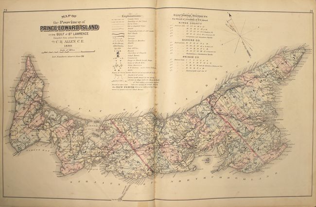
Auction 156, Lot 116
Subject: Prince Edward Island, Atlases
Illustrated Historical Atlas of the Province of Prince Edward Island..., 1880
Size: 14.7 x 17.8 inches (37.3 x 45.2 cm)
Estimate: $2,000 - $2,500
Highly Detailed Atlas of Prince Edward Island
Unsold
Closed on 2/17/2016
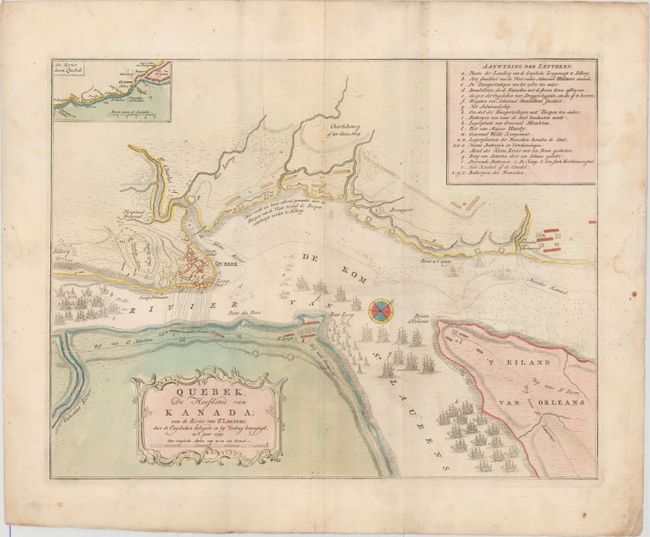
Auction 156, Lot 117
Subject: Quebec City, Canada
Tirion, Isaac
Quebek, de Hoofdstad van Kanada; aan de Rivier van St. Laurens: door Engelschen Belegerd en by Verdrag Bemagtigd, in 't Jaar 1759, 1759
Size: 17.1 x 13.1 inches (43.4 x 33.3 cm)
Estimate: $300 - $375
Sold for: $150
Closed on 2/17/2016
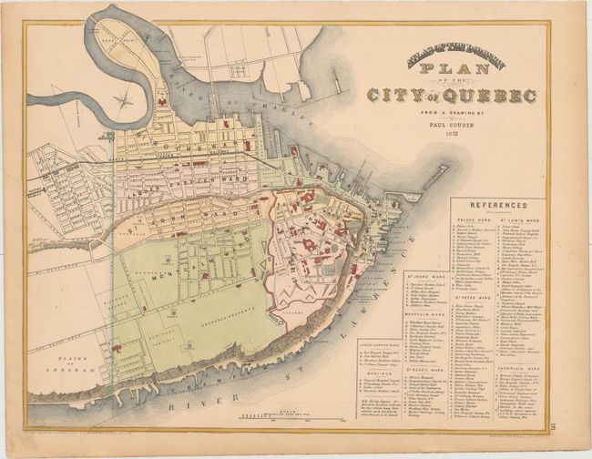
Auction 156, Lot 118
Subject: Quebec City, Canada
Atlas of the Dominion - Plan of the City of Quebec, 1875
Size: 15.4 x 12.5 inches (39.1 x 31.8 cm)
Estimate: $75 - $100
NO RESERVE
Sold for: $110
Closed on 2/17/2016
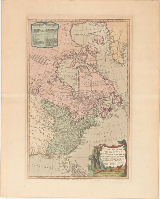
Auction 156, Lot 119
Subject: United States & Canada
Dunn, Samuel
A New Map of the United States of North America with the British Dominions on that Continent &c., 1786
Size: 12 x 18.5 inches (30.5 x 47 cm)
Estimate: $800 - $1,000
Unsold
Closed on 2/17/2016
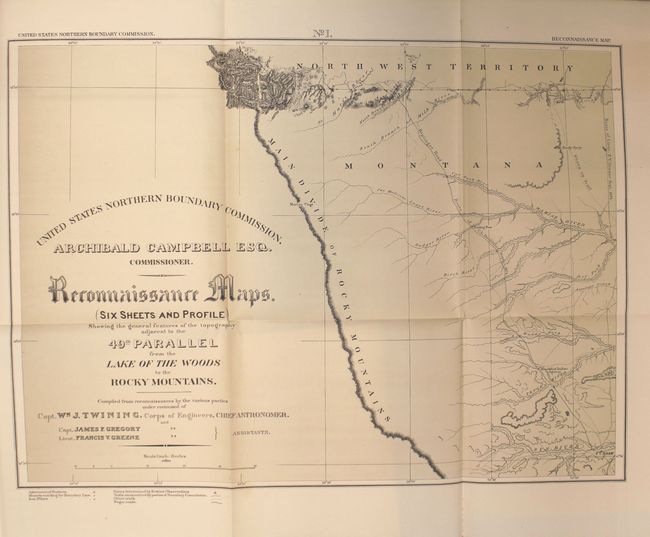
Auction 156, Lot 120
Subject: Canada & United States, Boundary Surveys
Twining, William J. (Capt.)
Reports upon the Survey of the Boundary Between the Territory of the United States and the Possessions of Great Britain from the Lake of the Woods to the Summit of the Rocky Mountains..., 1878
Size: 9.8 x 12.1 inches (24.9 x 30.7 cm)
Estimate: $400 - $500
Sold for: $200
Closed on 2/17/2016
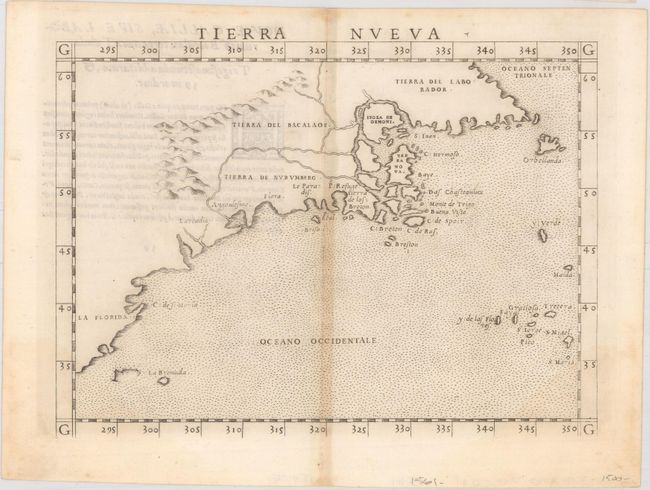
Auction 156, Lot 121
Subject: Eastern United States & Canada
Ruscelli, Girolamo
Tierra Nueva, 1562
Size: 9.6 x 7.1 inches (24.4 x 18 cm)
Estimate: $1,200 - $1,500
First State of Ruscelli's Map of the East Coast
Unsold
Closed on 2/17/2016
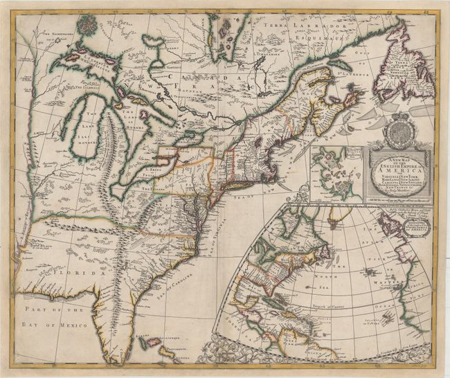
Auction 156, Lot 122
Subject: Colonial Eastern United States & Canada
Morden, Robert
A New Map of the English Empire in America viz Virginia Maryland Carolina Pennsylvania New York New Iarsey New England Newfoundland New France &c., 1695
Size: 23.4 x 19.8 inches (59.4 x 50.3 cm)
Estimate: $14,000 - $16,000
First State of Morden's Rare Map of the American Colonies
Unsold
Closed on 2/17/2016
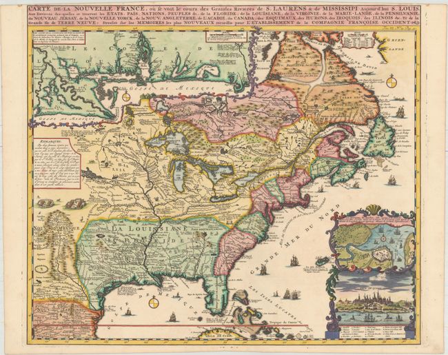
Auction 156, Lot 123
Subject: Colonial Eastern United States & Canada
Chatelain, Henry Abraham
Carte de la Nouvelle France, ou se voit le Cours des Grandes Rivieres de S. Laurens & de Mississipi Aujour d'hui S. Louis, aux Environs des-quelles se Trouvent les Etats, Pais, Nations, Peuples &c..., 1719
Size: 19.1 x 16.6 inches (48.5 x 42.2 cm)
Estimate: $2,200 - $2,500
One of the Most Informative 18th Century Maps of the French Possessions in North America
Sold for: $2,500
Closed on 2/17/2016
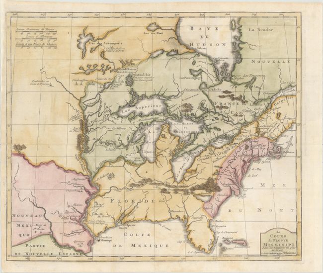
Auction 156, Lot 124
Subject: Colonial Eastern United States & Canada, Great Lakes
Bernard, Jean Frederic
Le Cours du Fleuve Missisipi Selon les Relations les Plus Modernes, 1737
Size: 17.3 x 14.7 inches (43.9 x 37.3 cm)
Estimate: $1,600 - $1,900
Scarce and Desirable Early Hennepin Variant
Sold for: $1,400
Closed on 2/17/2016
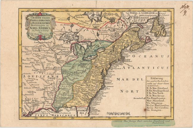
Auction 156, Lot 125
Subject: Colonial Eastern United States & Canada
Schreiber, Johann Georg
Charte von dem Engellaendischen u. Franzoesischen Besitzungen in Nord America, 1753
Size: 9.6 x 6.9 inches (24.4 x 17.5 cm)
Estimate: $400 - $500
Sold for: $200
Closed on 2/17/2016
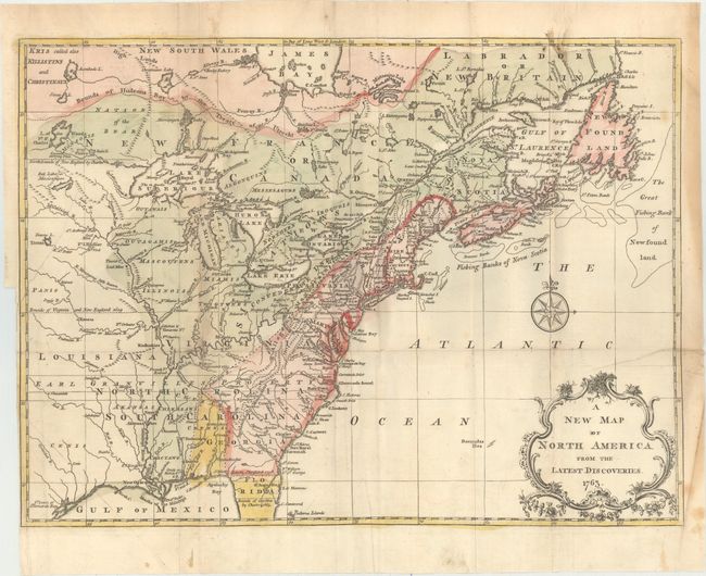
Auction 156, Lot 126
Subject: Colonial Eastern United States & Canada
Spilsbury, J.
A New Map of North America from the Latest Discoveries, 1763
Size: 14.9 x 10.9 inches (37.8 x 27.7 cm)
Estimate: $200 - $250
Sold for: $190
Closed on 2/17/2016
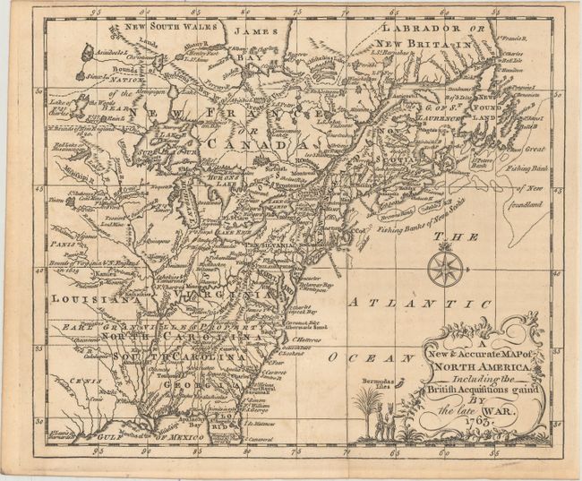
Auction 156, Lot 127
Subject: Colonial Eastern United States & Canada
Entick, John
A New & Accurate Map of North America, Including the British Acquisitions Gain'd by the Late War, 1763
Size: 9 x 7.6 inches (22.9 x 19.3 cm)
Estimate: $350 - $425
Sold for: $150
Closed on 2/17/2016
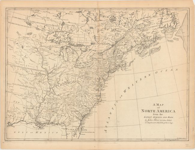
Auction 156, Lot 128
Subject: Colonial Eastern United States & Canada
Blair, Rev. John
A Map of North America from the Latest Surveys and Maps, 1768
Size: 22.8 x 16.7 inches (57.9 x 42.4 cm)
Estimate: $700 - $850
Sold for: $350
Closed on 2/17/2016
Auction 156, Lot 129
Subject: Colonial Eastern United States & Canada
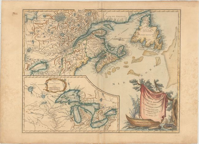
Bonne/Lattre
[On 2 Sheets] Partie de l'Amerique Septentrionale, qui Comprend le Canada, la Louisiane, le Labrador, le Groenland, la Nouvelle Angleterre, la Floride &c. Projettee et Assujettie aux Observations, 1773
Size: 17.1 x 11.8 inches (43.4 x 30 cm)
Estimate: $550 - $700
Sold for: $400
Closed on 2/17/2016
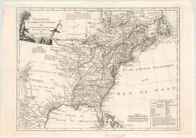
Auction 156, Lot 130
Subject: Eastern United States & Canada
Delamarche, Charles Francois
Etats-Unis de l'Amerique Septentrionale avec les Isles Royale, de Terre Neuve, de St. Jean, l'Acadie &c., 1785
Size: 24.6 x 18.7 inches (62.5 x 47.5 cm)
Estimate: $1,100 - $1,300
First Reference to Michigan as a Land Division of the United States
Sold for: $800
Closed on 2/17/2016
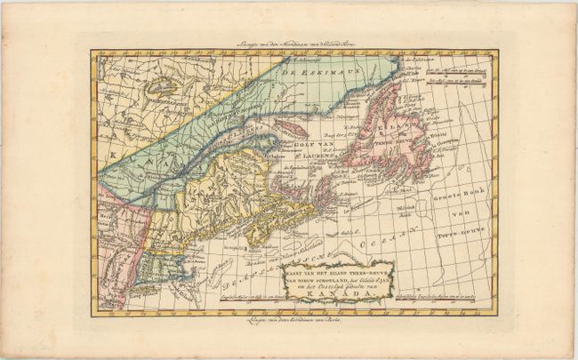
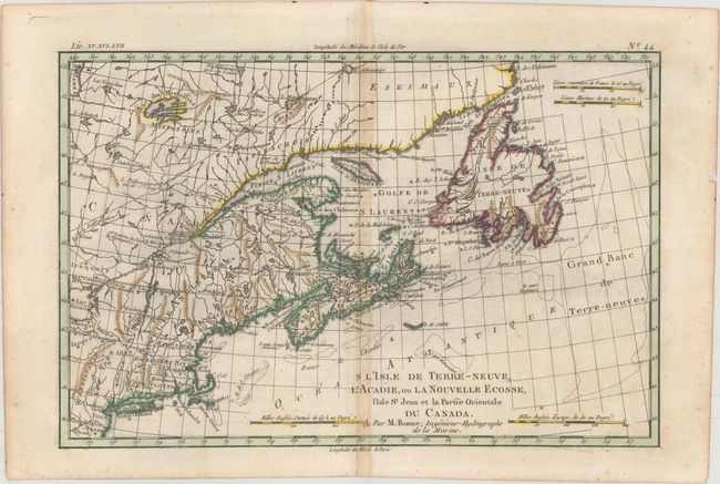
Auction 156, Lot 131
Subject: Eastern United States & Canada
Bachiene, Willem Albert
Kaart van het Eiland Terre-Neuve, van Nieuw Schotland, het Eiland St. Jan en het Oostelyk Gedeelte van Kanada, 1785
Size: 12.5 x 8.3 inches (31.8 x 21.1 cm)
Estimate: $300 - $375
Unsold
Closed on 2/17/2016
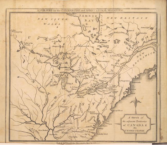
Auction 156, Lot 132
Subject: Eastern United States & Canada, Great Lakes
A Sketch of the Adjacent Territories of Canada & the United States [in] The Commercial and Agricultural Magazine..., 1799
Size: 5.1 x 8.4 inches (13 x 21.3 cm)
Estimate: $200 - $250
Sold for: $150
Closed on 2/17/2016
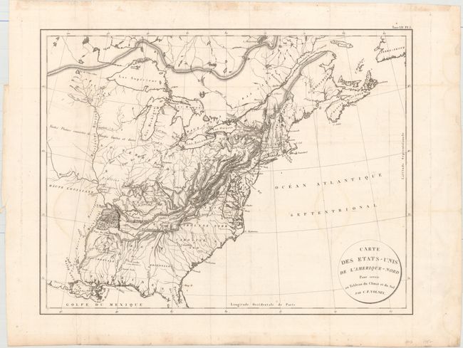
Auction 156, Lot 133
Subject: Eastern United States & Canada
Volney, C. F.
Carte des Etats-Unis de l'Amerique-Nord pour Servir au Tableau du Climat et du Sol , 1803
Size: 21.4 x 16.5 inches (54.4 x 41.9 cm)
Estimate: $240 - $300
Sold for: $140
Closed on 2/17/2016
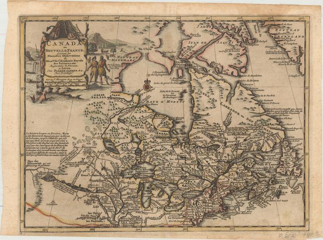
Auction 156, Lot 134
Subject: Colonial Northeastern United States & Canada
Aa, Pieter van der
Canada ou Nouvelle France, Suivant les Nouvelles Observations de Messrs. de l'Academie Royale des Sciences, etc. Augmentees de Nouveau, 1714
Size: 11.8 x 8.8 inches (30 x 22.4 cm)
Estimate: $400 - $475
Sold for: $350
Closed on 2/17/2016
Auction 156, Lot 135
Subject: Colonial Northeastern United States & Canada, Great Lakes
Robert de Vaugondy, Didier
Partie de l'Amerique Septent? qui Comprend la Nouvelle France ou le Canada, 1755
Size: 23.9 x 18.8 inches (60.7 x 47.8 cm)
Estimate: $600 - $750
Unsold
Closed on 2/17/2016
Auction 156, Lot 136
Subject: Colonial Northeastern United States & Canada
[Lot of 2] L'Isle de Terre-Neuve, l'Acadie, ou la Nouvelle Ecosse, l'Isle St Jean et la Partie Orientale du Canada [and] British North America Sheet 1, East. Newfoundland, New Brunswick, Nova Scotia, Prince Edward Island &c., 1775-1872
Size: See Description
Estimate: $200 - $230
NO RESERVE
Unsold
Closed on 2/17/2016
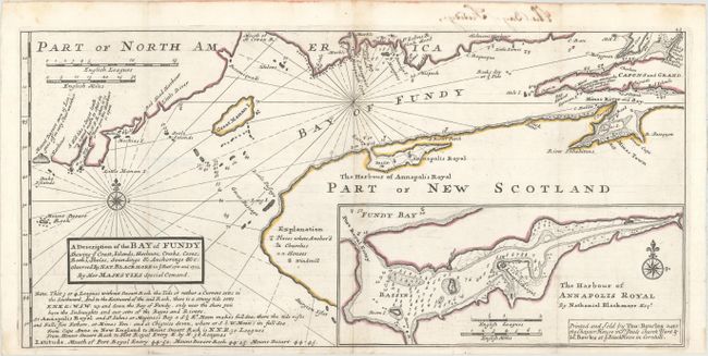
Auction 156, Lot 137
Subject: Bay of Fundy
Moll, Herman
A Description of the Bay of Fundy Shewing ye Coast, Islands, Harbours, Creeks, Coves, Rocks, Sholes, Soundings & Anchorings &c. Observed by Nat. Blackmore in ye Years 1711 and 1712, 1745
Size: 17.1 x 8.2 inches (43.4 x 20.8 cm)
Estimate: $250 - $325
Sold for: $220
Closed on 2/17/2016
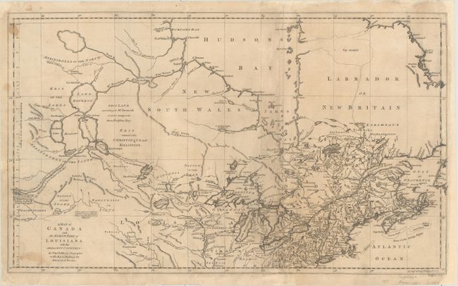
Auction 156, Lot 138
Subject: Colonial Northern United States & Canada, Great Lakes
Jefferys, Thomas
A Map of Canada and the North Part of Louisiana with the Adjacent Countrys, 1761
Size: 21.1 x 12.4 inches (53.6 x 31.5 cm)
Estimate: $1,000 - $1,300
Unsold
Closed on 2/17/2016
Auction 156, Lot 139
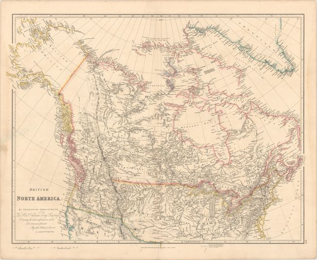
Subject: Canada, Northern United States & Alaska
Arrowsmith, John
British North America, 1834
Size: 24.5 x 19.6 inches (62.2 x 49.8 cm)
Estimate: $200 - $230
Sold for: $160
Closed on 2/17/2016
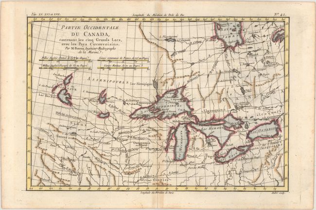
Auction 156, Lot 140
Subject: Great Lakes
Bonne, Rigobert
Partie Occidentale du Canada, Contenant les Cinq Grands Lacs, avec les Pays Circonvoisins, 1775
Size: 12.6 x 8.4 inches (32 x 21.3 cm)
Estimate: $240 - $300
Sold for: $180
Closed on 2/17/2016
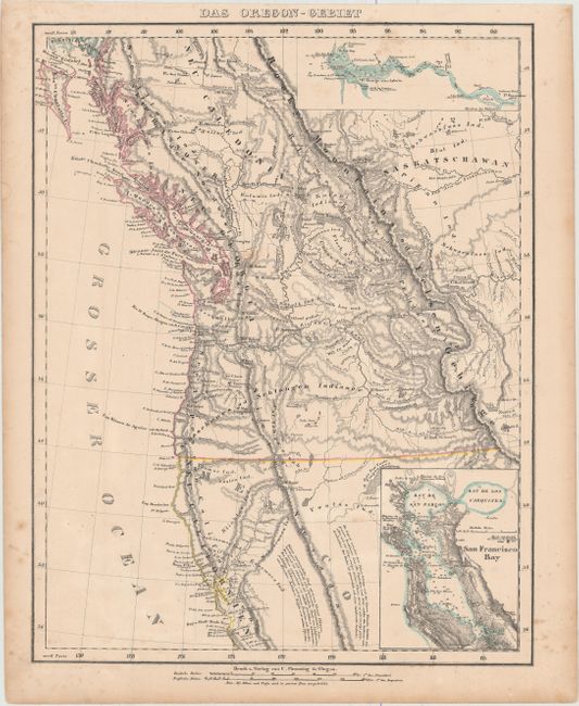
Auction 156, Lot 141
Subject: Western United States & Canada
Flemming, Carl
Das Oregon-Gebiet, 1848
Size: 12.6 x 16.4 inches (32 x 41.7 cm)
Estimate: $200 - $250
Sold for: $150
Closed on 2/17/2016
36 lots