Filtered by Category:Atlantic & Arctic(Show All Categories)
Showing results for:Auction 156
Catalog Archive
16 lots
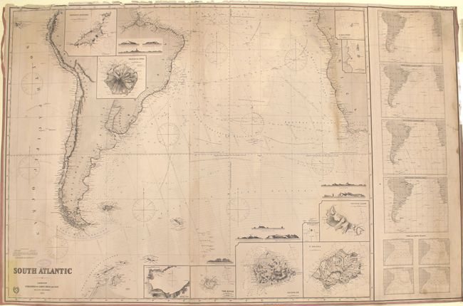
Auction 156, Lot 406
Subject: South Atlantic
Imray, James
South Atlantic, 1891
Size: 61.7 x 39.9 inches (156.7 x 101.3 cm)
Estimate: $350 - $425
Sold for: $125
Closed on 2/17/2016
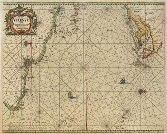
Auction 156, Lot 407
Subject: Atlantic Ocean
Loon, Jan van
Pascaerte van 't Westlyckste deel vande Spaense Zee, Tusschen Brasil, de Zoute en Vlaemse Eylanden, en Voortwestwart Op, 1661
Size: 21.2 x 17.1 inches (53.8 x 43.4 cm)
Estimate: $1,600 - $1,900
Scarce Chart of the North Atlantic Depicting the New England Coastline
Unsold
Closed on 2/17/2016
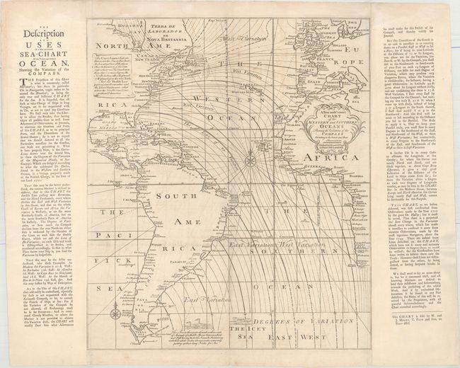
Auction 156, Lot 408
Subject: Atlantic Ocean
Mount & Page
A New and Correct Chart of the Western and Southern Oceans Shewing the Variations of the Compass According to the Latest and Best Observations, 1749
Size: 19.7 x 23.1 inches (50 x 58.7 cm)
Estimate: $1,600 - $1,900
Rare Halley Chart Showing Magnetic Variation
Unsold
Closed on 2/17/2016
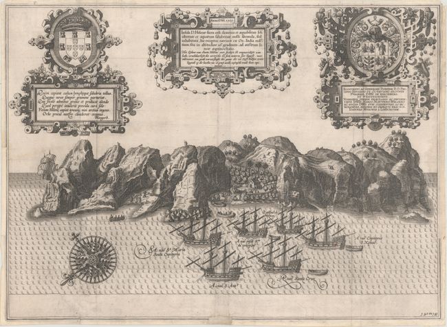
Auction 156, Lot 409
Subject: St. Helena
Linschoten, Jan Juygen van
Insula D. Helenae Sacra Coeli Clementia et Aequabilitate..., 1589
Size: 20 x 14.6 inches (50.8 x 37.1 cm)
Estimate: $600 - $750
Sold for: $600
Closed on 2/17/2016
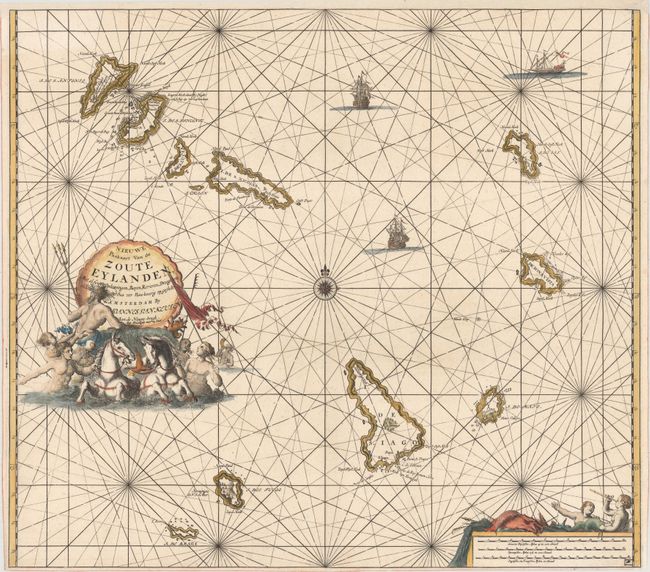
Auction 156, Lot 410
Subject: Cape Verde Islands
Keulen, Johannes van
Nieuwe Paskaart van de Zoute Eylanden..., 1697
Size: 22.9 x 20.4 inches (58.2 x 51.8 cm)
Estimate: $475 - $600
Sold for: $350
Closed on 2/17/2016
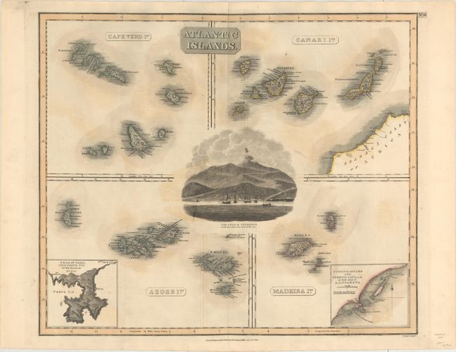
Auction 156, Lot 411
Subject: Cape Verde Islands, Canary Islands, Azores
Thomson, John
Atlantic Islands, 1814
Size: 23.2 x 19.6 inches (58.9 x 49.8 cm)
Estimate: $110 - $140
Sold for: $55
Closed on 2/17/2016
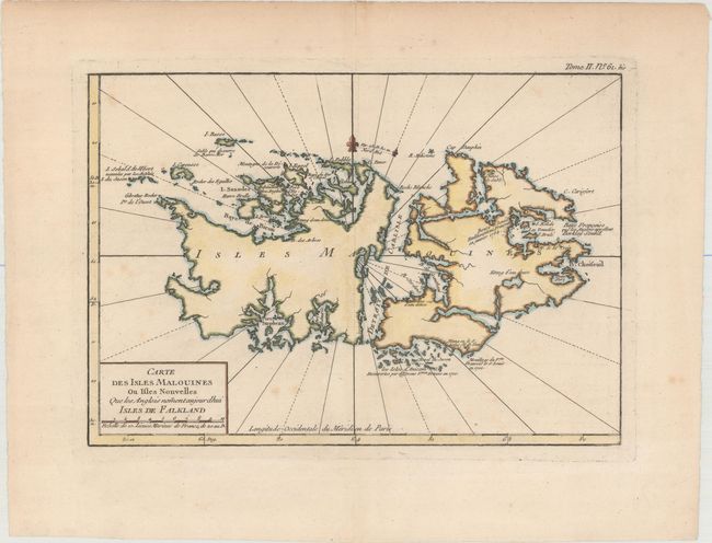
Auction 156, Lot 412
Subject: Falkland Islands
Bellin, Jacques Nicolas
Carte des Isles Malouines ou Isles Nouvelles que les Anglois Noment Aujourdhui Isles de Falkland, 1764
Size: 11.9 x 8.3 inches (30.2 x 21.1 cm)
Estimate: $180 - $220
Sold for: $130
Closed on 2/17/2016
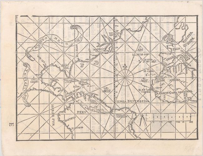
Auction 156, Lot 413
Subject: North Atlantic
De Medina, Pedro
Mundo Novo, 1554
Size: 6.9 x 4.7 inches (17.5 x 11.9 cm)
Estimate: $7,000 - $9,000
Extremely Rare Italian Edition of Medina's Map in Excellent Condition
Sold for: $4,750
Closed on 2/17/2016
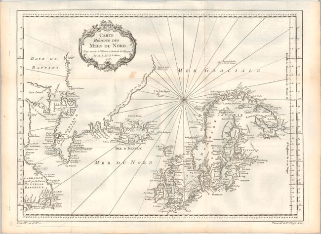
Auction 156, Lot 414
Subject: North Atlantic
[Lot of 2] Carte Reduite des Mers du Nord, pour Servir a l'Histoire Generale des Voyages [and] Carte du Groenland, 1758-70
Size: See Description
Estimate: $160 - $190
Sold for: $60
Closed on 2/17/2016
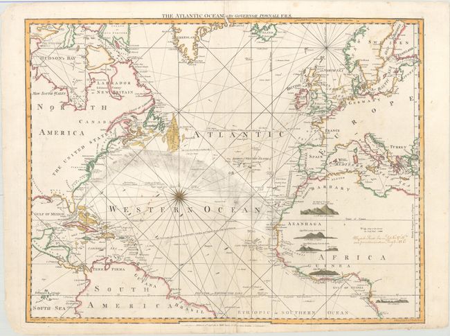
Auction 156, Lot 415
Subject: North Atlantic
Jefferys/Sayer & Bennett
The Atlantic Ocean by Governor Pownall F.R.S., 1787
Size: 25.1 x 19.7 inches (63.8 x 50 cm)
Estimate: $1,400 - $1,700
Scarce Sea Chart with References to African Slave Trade
Sold for: $1,000
Closed on 2/17/2016
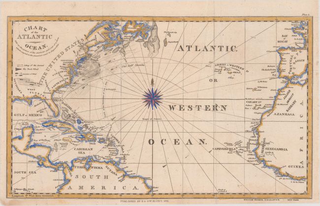
Auction 156, Lot 416
Subject: North Atlantic
Blunt, Edmund
Chart of the Atlantic Ocean. With an Illustration of the Character and Rout of a Storm Which Occured on the American Coast in August 1830, 1831
Size: 12.4 x 7.4 inches (31.5 x 18.8 cm)
Estimate: $100 - $130
Sold for: $75
Closed on 2/17/2016
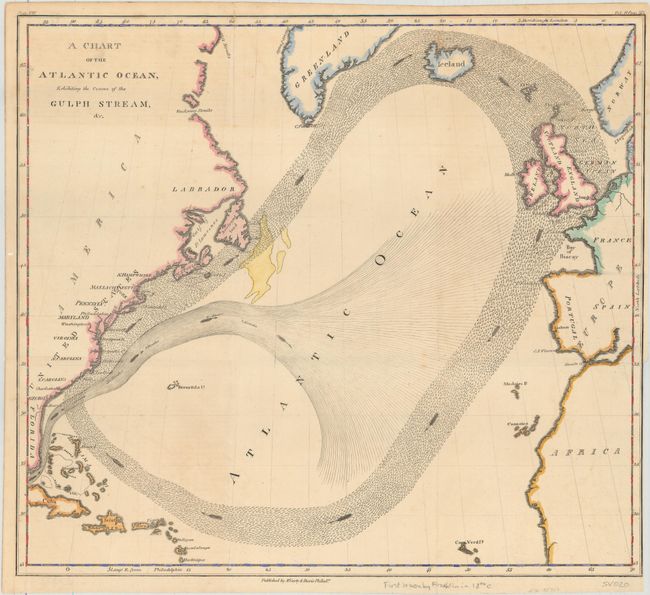
Auction 156, Lot 417
Subject: North Atlantic
Franklin, Benjamin
A Chart of the Atlantic Ocean, Exhibiting the Course of the Gulph Stream, &c., 1834
Size: 13.8 x 12.3 inches (35.1 x 31.2 cm)
Estimate: $400 - $500
Sold for: $300
Closed on 2/17/2016
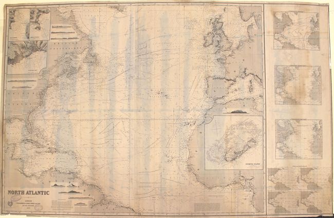
Auction 156, Lot 418
Subject: North Atlantic
Imray, James
North Atlantic, 1890
Size: 62.6 x 40.1 inches (159 x 101.9 cm)
Estimate: $550 - $700
Sold for: $300
Closed on 2/17/2016
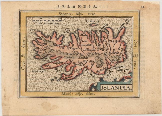
Auction 156, Lot 419
Subject: Iceland
Ortelius/Coignet
Islandia, 1601
Size: 4.6 x 3.4 inches (11.7 x 8.6 cm)
Estimate: $240 - $300
Sold for: $180
Closed on 2/17/2016
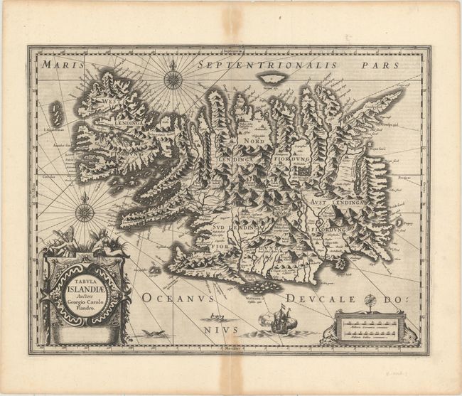
Auction 156, Lot 420
Subject: Iceland
Hondius/Jansson
Tabula Islandiae Auctore Georgio Carolo Flandro, 1636
Size: 19.5 x 15.1 inches (49.5 x 38.4 cm)
Estimate: $550 - $700
Rare Example from the Only English Text Edition of Mercator's Atlas
Sold for: $400
Closed on 2/17/2016
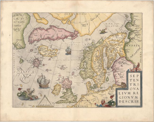
Auction 156, Lot 421
Subject: Arctic & Scandinavia
Ortelius, Abraham
Septentrionalium Regionum Descrip., 1570
Size: 19.3 x 14.3 inches (49 x 36.3 cm)
Estimate: $2,000 - $2,300
Early Example of Ortelius' Map of the Arctic with Mythical Islands
Unsold
Closed on 2/17/2016
16 lots