Subject: Eastern United States & Canada
Period: 1785 (dated)
Publication:
Color: Hand Color
Size:
24.6 x 18.7 inches
62.5 x 47.5 cm
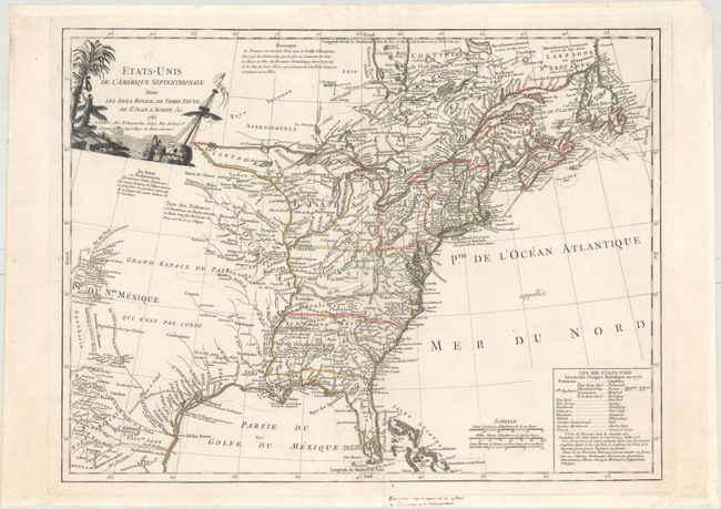
This handsome map covers the newly created United States and extends to take in much of the Louisiana Territory and part of New Mexico. It also extends to show parts of eastern Canada and the Bahamas. Detail along the Rio del Norte includes Taos and Santa Fe. The map identifies many Indian villages and tribal territory. There are extensive notes throughout regarding early explorers such as De Soto and La Salle, Indian nations, forts and other points of early interest. One of the most intriguing features of the map is the text block, which lists the original 13 states with their capitals and also ten new states proposed in the Jeffersonian Ordinance of 1784: Silvania, Michigania, Chersonesus, Arsenistpia, Metropotamia, Illinoia, Saratoga, Washington, Polypotamia, and Pelisypia. This is the first reference on any map to Michigan as applying to a land division of the United States. The title cartouche has a nautical theme.
References: Karpinski (MI) pp. 179-180, #CIII; McCorkle #785.5; Seller & Van Ee #187.
Condition: A
A very attractive example on watermarked paper. There are a few tiny edge chips and tears confined to the blank margins that have been closed on verso with archival material. A manuscript notation is confined to the bottom blank margin.