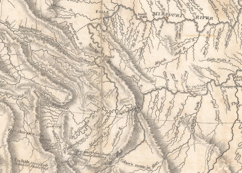
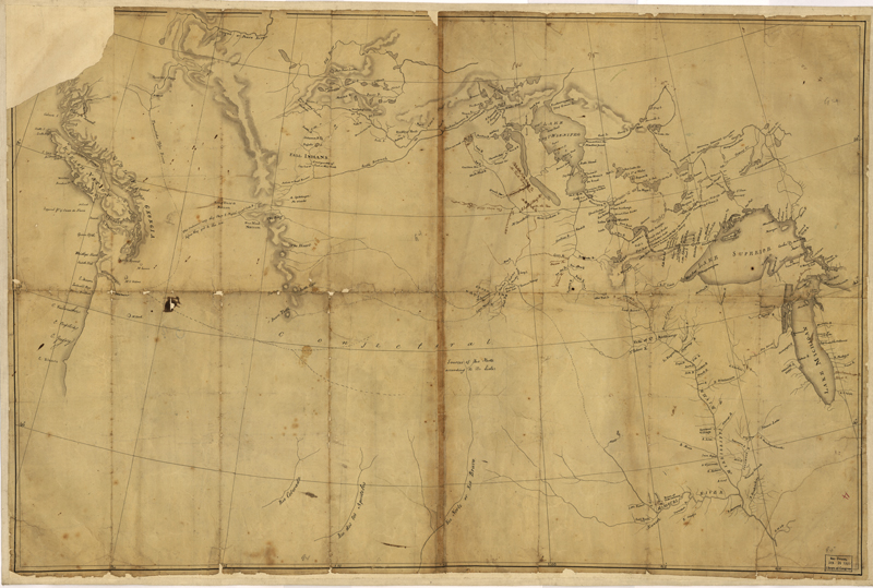
The Missouri River forms at the confluence of the Jefferson, Madison, and Gallatin rivers as shown on Lewis & Clark's 1814 map. (Image courtesy of Old World Auctions - click on image view full map.)
Lewis & Clark: Mapping the West
by Jon Dotson
Eliane and I recently traveled to Bozeman, Montana on vacation to experience the expansive Rocky Mountains in all their splendor. During the trip, I found myself fully engrossed in the beauty of the region – from snow-capped peaks to abundant wildlife and the majestic Gallatin and Yellowstone rivers. Experiencing this amazing environment reminded me of the Lewis & Clark expedition, as the 45-member Corps of Discovery had explored this region extensively. While I could easily navigate the rugged terrain in our rented SUV, use GPS to find the fastest route, or ask Siri for directions, early western explorers had no such luxuries.
Following the acquisition of the Louisiana Purchase in April 1803, the United States gained over 800,000 square miles of land west of the Mississippi River and nearly doubled its territory in the process. Thomas Jefferson understood the potential economic and political value of this acquisition, and organized a federally funded venture to explore these vast new lands. The goals of this expedition were to seek new trade routes, establish good relations with the Indian tribes in the region, and to determine if a Northwest Passage existed via the Missouri and Columbia Rivers to the Pacific Ocean. Jefferson’s specific directive was as follows: “to explore the Missouri River, and such principal stream of it, as, by its course and communication with the waters of the Pacific Ocean, may offer the most direct and predictable water communication across this continent, for the purposes of commerce.” Thomas Jefferson selected his former personal secretary and Army Captain, Meriwether Lewis, to lead the expedition. Lewis then engaged William Clark, who had served with him in the military and possessed strong draftmanship and knowledge of the frontier. Embarking on this epic journey, Lewis and Clark relied on little more than a handful of basic maps and scientific instruments to chart the 4,162 miles from the mouth of the Missouri River to the Pacific Ocean.
The “Blank Map”
Arguably the most important map that Lewis and Clark carried with them from St. Louis was a composite map drawn by Nicolas King. King had joined the staff of the Surveyor’s Office in Washington in 1796, and became the city’s Surveyor in 1803. In March of that year, Albert Gallatin, Secretary of the Treasury under Jefferson, instructed King “to project a blank map” covering the region from the Mississippi River and Lake Superior to the Pacific Ocean. Gallatin provided King with a list of maps that he thought would be useful in its compilation. After careful consideration, King narrowed down his list of source maps to 3 maps by Aaron Arrowsmith showing the interior parts of North America, Delisle’s Carte de la Louisiane et du Cours du Mississipi for the headwaters of the Rio Grande, and explorer David Thompson’s manuscript map for the Great Bend of the Missouri River (near present-day Bismarck).
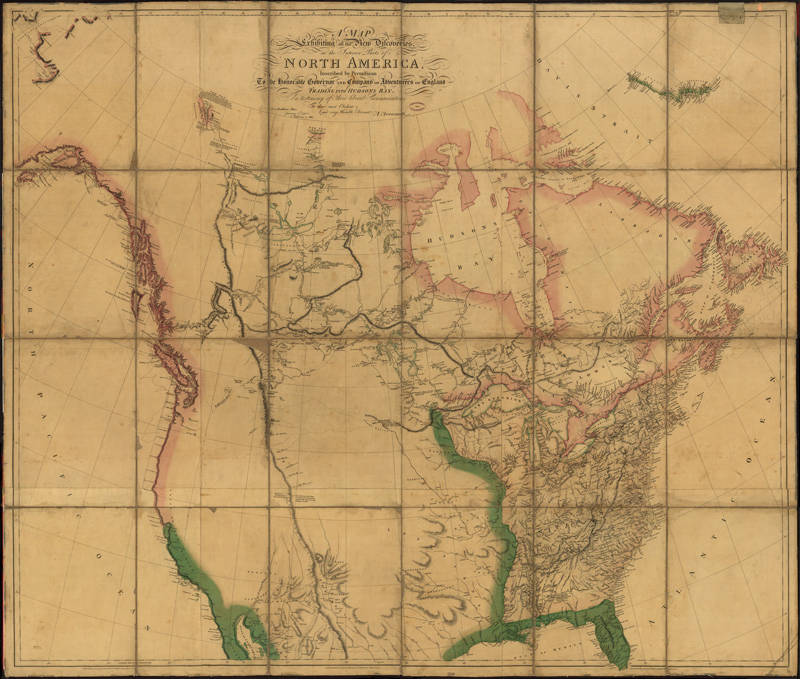
Aaron Arrowsmith’s A Map Exhibiting All the New Discoveries in the Interior Parts of North America…, 1802. (Image courtesy of The Library of Congress)
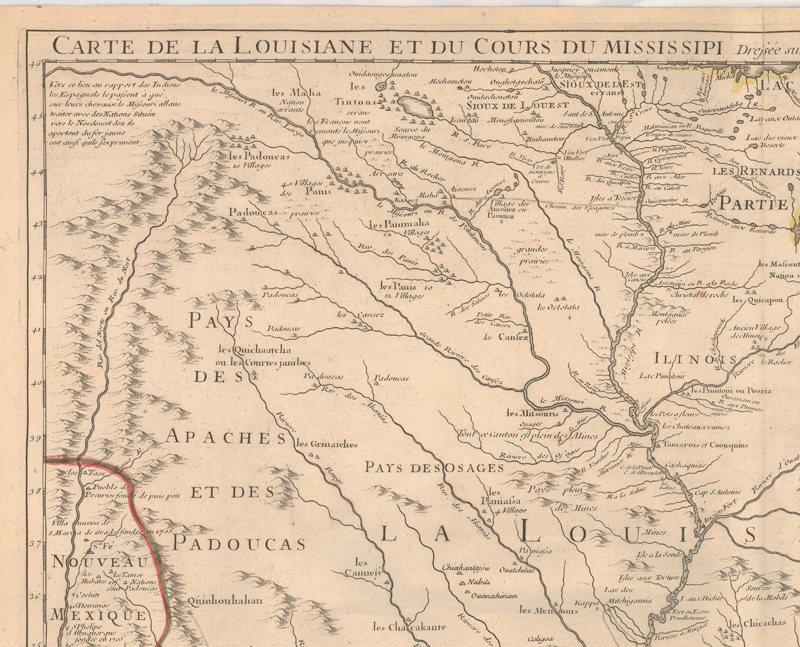
The northwestern quadrant of Guillaume Delisle’s Carte de la Louisiane et du Cours du Mississipi…depicting the headwaters of the Rio Grande River. (Image courtesy of Old World Auctions - click on image to view full map.)
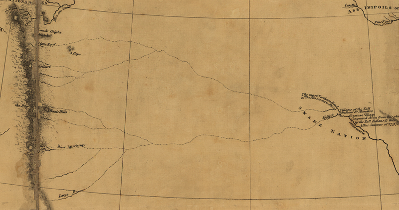
The fact that Arrowsmith’s maps were used as the primary source for much of King’s map speaks to the quality of his works. Jefferson was particularly fond of Arrowsmith’s maps and noted “I know the engraving is superiorly well done.” Arrowsmith also had access to valuable information from the North American wilderness via the British fur trading companies in the region. One very important map that influenced his depiction of the Upper Missouri River was drawn by Blackfoot Chief Ackomokki. The chief sketched out (likely on dirt) the river routes that his warriors would use on their raids against the Shoshone, and Peter Fidler of the Hudson Bay Company recorded it on paper. Fidler’s sketch map made its way back to London, where Arrowsmith incorporated it onto his map as a series of dotted lines signifying possible sources of the Missouri River. Ackomokki’s maps (he created several which were transcribed by others onto paper) are notable as the first to show detail of the Front Range of the Rockies based on personal observation. In a note to the Governor of the Hudson Bay Company, Fidler concluded that “this Indian map conveys much information where European documents fail.”
Arrowsmith’s depiction of possible sources of the Missouri River based upon Ackomokki’s sketch map. (Image courtesy of The Library of Congress)
King followed Arrowsmith’s portrayal of the Missouri River, no doubt the most important feature for Lewis and Clark, in addition to his representation of the Pacific Coast (which in turn was based upon Vancouver and Cook’s recent voyages) to assemble his final product for Jefferson, Gallatin, and the Corps of Discovery.
Nicolas King “Blank Map” of 1803 used for the expedition. (Image courtesy of The Library of Congress)
The Instruments
While Nicolas King’s role was to establish a base map for Lewis and Clark’s expedition, it was William Clark’s field surveying and Meriwether Lewis’ astronomical observations that filled in the blank spaces. Thomas Jefferson was insistent on meticulous measurements and record keeping throughout the Corps’ journey. His specific instructions for Lewis and Clark were to observe latitude and longitude, starting at the mouth of the Missouri, and at “all remarkable points of the river, & especially at the mouths of rivers, at rapids, at islands & other places distinguished by such natural marks & characters of a durable kind, as they may with certainty be recognized hereafter.” In order to fulfill this obligation, Lewis procured levels, pocket compasses, a surveyor’s compass (or circumferentor), rods and chains, telescopes, a sextant, an octant (or Hadley’s quadrant), a chronometer, drafting instruments, and more. Various books and tables were also carried along to assist in computing their precise location.
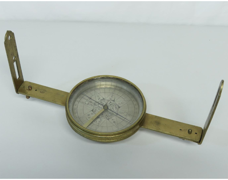
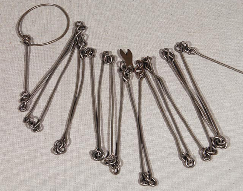
Examples of two instruments used frequently by William Clark: A Surveyor’s Compass & Gunter’s Chain. (Images courtesy of The Smithsonian)
For William Clark, who was primarily responsible for charting the Corps’ course, the surveyor’s compass was the tool he used most. Clark used the dead reckoning method, where straight-line distances are recorded between turns and compass bearings are noted at each turn. It was a relatively quick and easy process that could be done on a daily basis and then recorded on a map. Clark also used a Gunter’s chain (measuring 33 feet long) for determining shorter distances accurately, even using it at the arduous 18-mile portage at Great Falls. Other techniques that Clark used were precision pacing (at the Big Bend) and a log-line, which was used for measuring river distance and velocity.
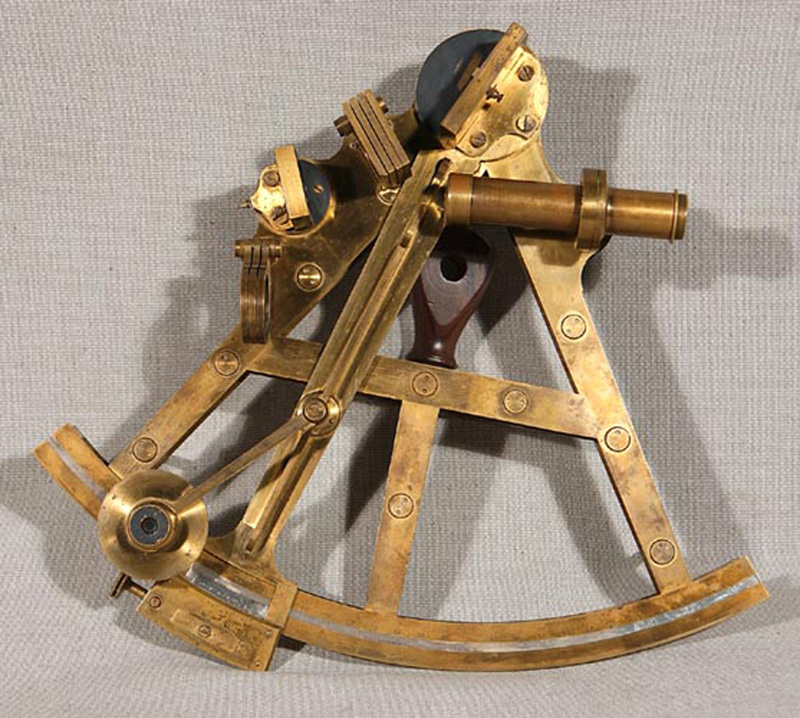
While Clark handled the measurements on the trail, Meriwether Lewis was tasked with measuring latitude and longitude. He had no previous experience in this regard, so after Jefferson (while serving as President!) taught him some of the basics, Lewis received formal training from Andrew Ellicott and mathematician Robert Patterson. Lewis was also given astronomical formulas that Patterson told Jefferson would render “the process extremely easy even to boys or common sailors.” While calculating latitude was somewhat laborious – theirs was a ten-stop procedure taken at midday – it was not difficult to ascertain. Longitude on the other hand, was more challenging due to a lack of accurate timepieces. The one timepiece they had, an Arnold’s watch (chronometer), had never been used on a long overland journey and Lewis found that it was prone to malfunction. So instead, he utilized the reliable movements of the sun and moon. In the evening, often with assistance from Clark, Lewis would take astronomical readings using either a 14" octant or 10” sextant. These two triangular-shaped tools measured the angle of the sun, stars and moon using a movable arm, mirrors, and eyepiece.
This sextant, produced in the late 18th century, is similar to the one used by Meriwether Lewis on the journey. (Image courtesy of The Library of Congress)
Latitude and longitude were recorded in part to compensate for the errors inherent with Clark’s field measurements. As instructed by Jefferson, the Corps made multiple copies of these geographic measurements as a safeguard in case of loss or damage.
The Clark Maps – Filling in the Blanks
Over the course of the expedition, Clark updated the King map and created his own field surveys. These new maps were generated from two primary sources – the geographical data coming from their own measurements coupled with information gleaned from interviews with fur traders and Native Americans about areas the Corps did not explore. During the winter breaks at Fort Mandan and Fort Clatsop, Clark produced numerous accurate maps of the Northwest. In fact, Lewis made over 70 maps while on the 2-year, 4-month and 10-day expedition. Most were route maps covering 1-2-week periods along with several detailed maps of the Columbia River.
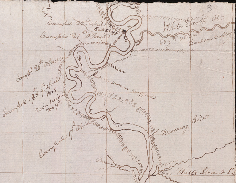
Clark’s route map for the period April 14-23, 1805. It shows part of North Dakota where the White Earth River enters the Missouri River. Clark notes the widths of both rivers, camp location/dates, and includes short descriptions of the land. (Image Courtesy of Yale University)
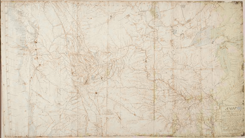
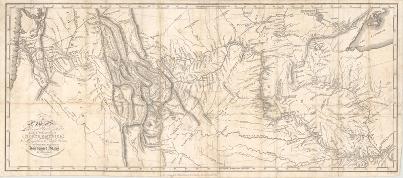
After the Corps of Discovery returned to St. Louis in September 1806, Clark shifted gears to completing a singular map of the West. It took him until 1810 to complete the map, which measured an impressive 32” x 52”. The delay was likely due in part to his new position as Superintendent for Indian Affairs. There was benefit from this interlude, however, as Clark was able to include new information from other explorers, including fur trader Manuel Lisa (Montana), mountain man John Colter (Yellowstone region, Teton Range), and explorer Zebulon Pike (Great Plains, Southwest) into the final production. Upon completion, Clark sent his map to Samuel Lewis in Philadelphia for final editing before it was engraved by Samuel Harrison for the official record of the expedition in 1814, published in both Philadelphia and London.
Clark’s comprehensive map of the West, drawn in manuscript in 1810. (Image Courtesy of Yale University)
The engraved version of the map offered to the public in 1814. (Image courtesy of Old Word Auctions - click on the image for a zoomable version.)
While the journey to the Pacific Ocean did not yield an easy course that Jefferson had hoped for, it did provide the nation with the first accurate depiction of the West. With their map, now any citizen could visualize the real potential for settlement and economic opportunity beyond the Mississippi River. Fur traders, trappers, and other explorers quickly followed in the Corps footsteps, followed shortly thereafter by missionaries and early emigrants. In effect, the Lewis and Clark map served as the GPS for the West over the next 30 years until John Fremont’s updated maps of the 1840s.
“The work we are now doing, is, I trust, done for prosperity, in such a way that they need not repeat it…We shall delineate with correctness the great arteries of this great country: those who come after us will extend the ramifications as they become acquainted with them, and fill up the canvas we began.” – Thomas Jefferson
REFERENCES
Allen, John Logan, Mapping Unknown Lands, Lewis & Clark Trail Heritage Foundation. https://lewis-clark.org/sciences/geography/mapping-unknown-lands/
Bedini, Silvio, Thinkers and Tinkers – Early American Men of Science, Charles Scribner’s Sons, New York, 1975.
Clark, William, [Lewis and Clark Expedition Maps], Unpublished Manuscripts, Held at Yale University, 1803-10. https://orbis.library.yale.edu/vwebv/holdingsInfo?bibId=3163629
Ehrenberg, Ralph E. & Viola, Herman J., Mapping the West with Lewis & Clark, The Library of Congress, Washington D.C., 2015.
Kovarsky, Joel, The True Geography of Our Country – Jefferson’s Cartographic Vision, University of Virginia Press, Charlottesville, VA, 2014.
Luebke, Kaye & Moulton, Mapping of the North American Plains - Essays in the History of Cartography, University of Oklahoma Press, Norman, OK, 1987.