Showing Featured Lots(remove filter)
Showing results for:Auction 190
Catalog Archive
54 lots
Page 1 of 2
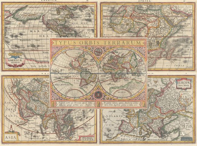
Auction 190, Lot 1
Subject: World & Continents
Jansson, Jan
[Lot of 5] Typus Orbis Terrarum [with] Americae Descriptio [and] Africae Descriptio [and] Asia [and] Europae Nova Tabula, 1634
Size: 8 x 5.6 inches (20.3 x 14.2 cm)
Estimate: $2,200 - $2,500
Matching Set from Latin Edition of Atlas Minor
Sold for: $1,700
Closed on 11/16/2022
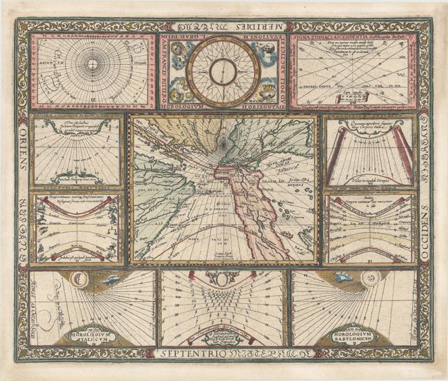
Auction 190, Lot 5
Subject: World
Ritter, Franz
[Untitled - World and Horological Diagrams], 1607
Size: 13.6 x 11.2 inches (34.5 x 28.4 cm)
Estimate: $3,250 - $4,000
Ritter's Unusual Sun-Dial World Map - First State
Sold for: $2,400
Closed on 11/16/2022
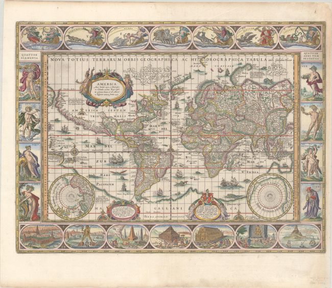
Auction 190, Lot 6
Subject: World
Blaeu, Willem
Nova Totius Terrarum Orbis Geographica ac Hydrographica Tabula, 1640
Size: 21.6 x 16.2 inches (54.9 x 41.1 cm)
Estimate: $12,000 - $15,000
Blaeu's Magnificent Carte-a-Figures World Map with Rare Blank Verso
Sold for: $9,000
Closed on 11/16/2022
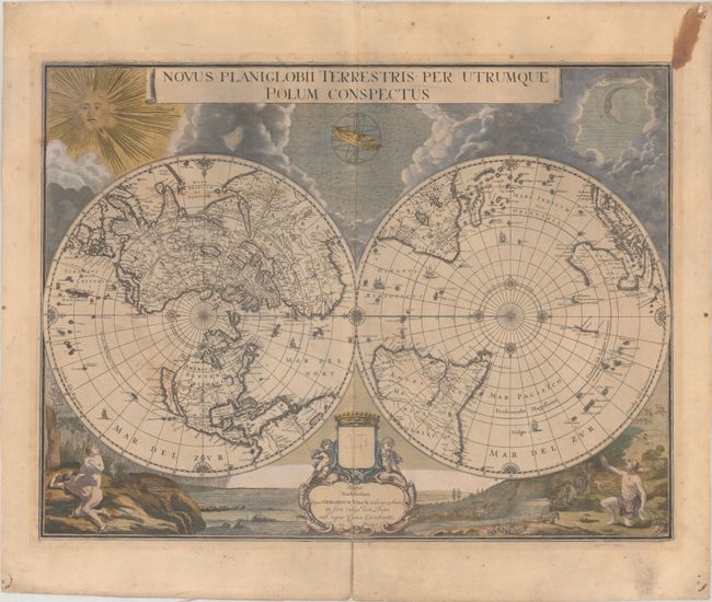
Auction 190, Lot 9
Subject: World
Blaeu/Valck
Novus Planiglobii Terrestris per Utrumque Polum Conspectus, 1695
Size: 21.5 x 16.2 inches (54.6 x 41.1 cm)
Estimate: $4,000 - $4,750
Superb World Map on a Polar Projection
Sold for: $3,000
Closed on 11/16/2022
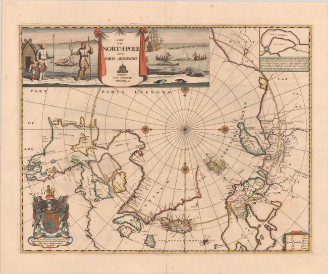
Auction 190, Lot 32
Subject: North Pole
Pitt, Moses
A Map of the North-Pole and the Parts Adioining, 1680
Size: 23.1 x 18.1 inches (58.7 x 46 cm)
Estimate: $3,500 - $4,250
Beautiful English Map of the North Pole
Sold for: $2,300
Closed on 11/16/2022
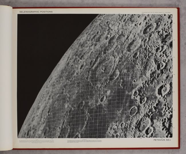
Auction 190, Lot 42
Subject: Moon
U.S. Air Force
Orthographic Atlas of the Moon - Supplement Number One to the Photographic Lunar Atlas, 1960
Size: 22.8 x 18.5 inches (57.9 x 47 cm)
Estimate: $1,200 - $1,500
Important Milestone in Preparation for 1969 Moon Landing
Unsold
Closed on 11/16/2022
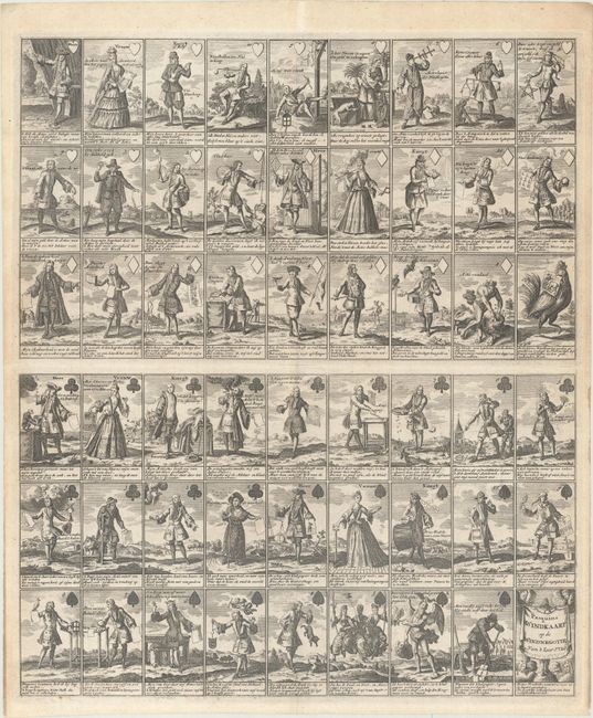
Auction 190, Lot 48
Subject: Cartographic Miscellany, Playing Cards
Anon.
Pasquins Windkaart. Op de Windnegotie van 't Iaar 1720, 1720
Size: 17.3 x 20.4 inches (43.9 x 51.8 cm)
Estimate: $1,500 - $1,800
Sheet of Playing Cards Satirizing the Mississippi Bubble
Unsold
Closed on 11/16/2022
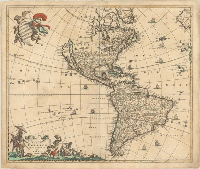
Auction 190, Lot 57
Subject: Western Hemisphere - America
Wit, Frederick de
Novissima et Accuratissima Totius Americae Descriptio, 1678
Size: 22.8 x 19.3 inches (57.9 x 49 cm)
Estimate: $1,400 - $1,700
De Wit's Derivative of Visscher's Classic Map of the Americas with the Island of California
Sold for: $1,300
Closed on 11/16/2022
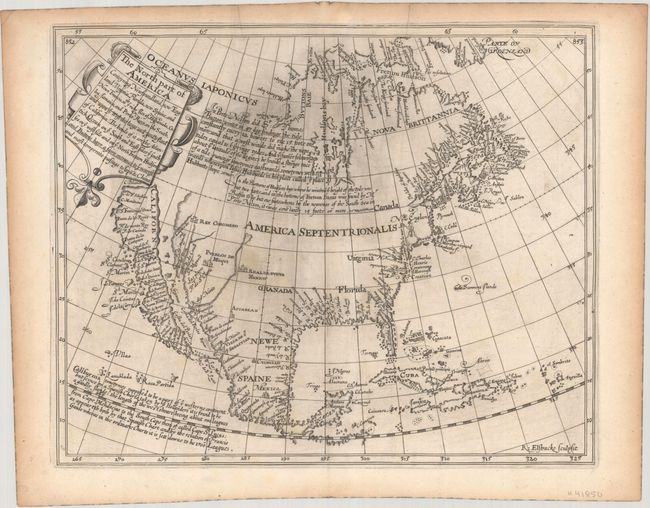
Auction 190, Lot 69
Subject: Colonial North America
Briggs, Henry
The North Part of America Conteyning Newfoundland, New England, Virginia, Florida, New Spaine, and Nova Francia..., 1625
Size: 13.8 x 11.2 inches (35.1 x 28.4 cm)
Estimate: $16,000 - $19,000
First English Map to Show California as an Island
Sold for: $11,500
Closed on 11/16/2022
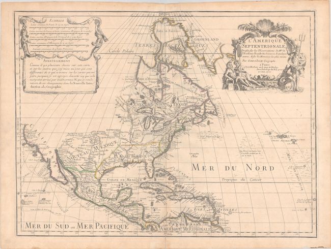
Auction 190, Lot 70
Subject: Colonial North America
Delisle, Guillaume
L'Amerique Septentrionale. Dressee sur les Observations de Mrs. de l'Academie Royale des Sciences. & Quelques Autres, & sur les Memoires les Plus Recens, 1700
Size: 23.6 x 17.9 inches (59.9 x 45.5 cm)
Estimate: $1,900 - $2,200
Delisle's Foundation Map of North America
Sold for: $1,200
Closed on 11/16/2022
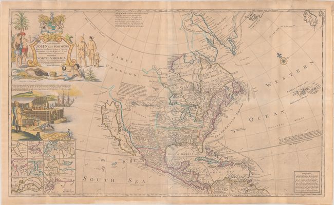
Auction 190, Lot 71
Subject: Colonial North America
Moll, Herman
To the Right Honourable John Lord Sommers Baron of Evesham ... This Map of North America According to ye Newest and Most Exact Observations..., 1730
Size: 38 x 22.7 inches (96.5 x 57.7 cm)
Estimate: $4,000 - $4,750
Moll's Famous "Codfish Map" of North America
Sold for: $3,750
Closed on 11/16/2022
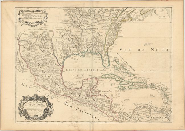
Auction 190, Lot 82
Subject: Colonial Eastern North America
Delisle, Guillaume
Carte du Mexique et de la Floride des Terres Angloises et des Isles Antilles du Cours et des Environs de la Riviere de Mississipi..., 1703
Size: 25.4 x 18.7 inches (64.5 x 47.5 cm)
Estimate: $1,800 - $2,100
Landmark in American Cartography - First Printed Map to Accurately Depict the Mouth of the Mississippi River
Sold for: $1,100
Closed on 11/16/2022
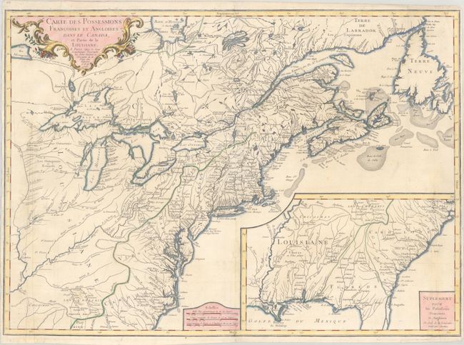
Auction 190, Lot 100
Subject: Colonial Eastern United States & Canada
Longchamp, S. G. (Sieur)
Carte des Possessions Francoises et Angloises dans le Canada, et Partie de la Louisiane, 1756
Size: 30.1 x 21.5 inches (76.5 x 54.6 cm)
Estimate: $1,400 - $1,700
First State of Longchamp's Map of the Theater of the French and Indian War
Sold for: $1,000
Closed on 11/16/2022
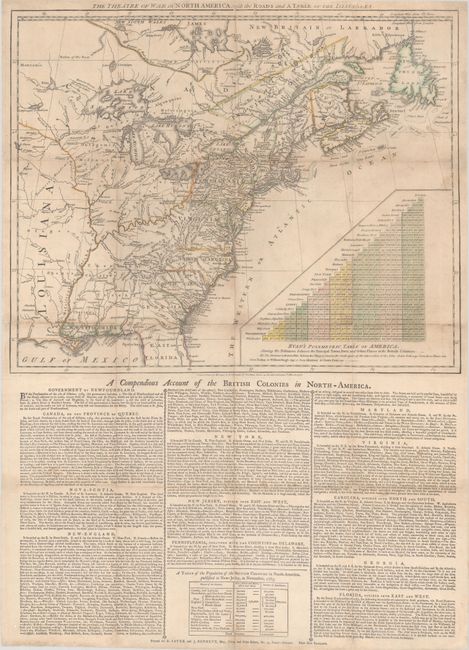
Auction 190, Lot 102
Subject: Colonial Eastern United States & Canada
Sayer & Bennett
The Theatre of War in North America, with the Roads and a Table of the Distances, 1776
Size: 20.1 x 16.1 inches (51.1 x 40.9 cm)
Estimate: $9,500 - $12,000
Early Broadside Informing British Readers of the Brewing War - First State
Sold for: $7,000
Closed on 11/16/2022
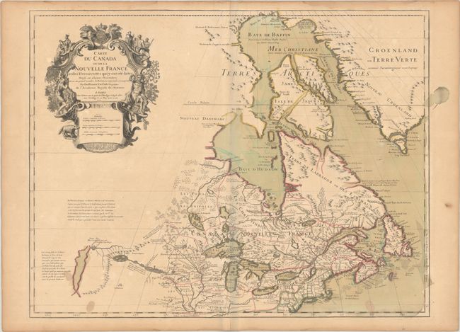
Auction 190, Lot 104
Subject: Colonial Northeastern United States & Canada, Great Lakes
Delisle, Guillaume
Carte du Canada ou de la Nouvelle France et des Decouvertes qui y ont ete Faites..., 1703
Size: 25.6 x 19.6 inches (65 x 49.8 cm)
Estimate: $2,000 - $2,300
Delisle's Seminal Map of Canada and the Great Lakes in Contemporary Color
Sold for: $1,100
Closed on 11/16/2022
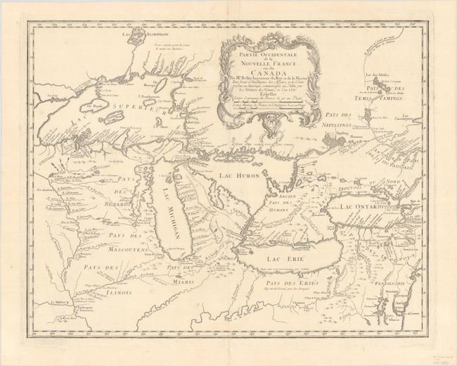
Auction 190, Lot 111
Subject: Colonial Great Lakes
Bellin/Homann Heirs
Partie Occidentale de la Nouvelle France ou du Canada, 1755
Size: 21.3 x 16.9 inches (54.1 x 42.9 cm)
Estimate: $1,600 - $1,900
Influential Map of the Great Lakes
Sold for: $2,100
Closed on 11/16/2022
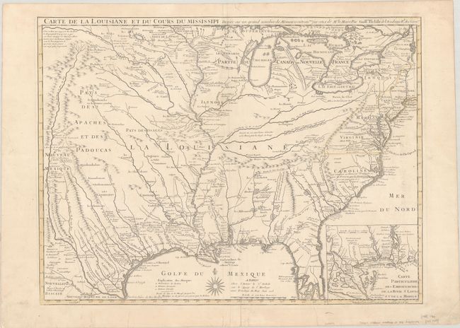
Auction 190, Lot 128
Subject: Colonial Eastern United States, Louisiana Territory
Delisle/Buache
Carte de la Louisiane et du Cours du Mississipi Dressee sur un Grand Nombre de Memoires Entrautres sur ceux de Mr. le Maire, 1745
Size: 25.4 x 19.1 inches (64.5 x 48.5 cm)
Estimate: $1,800 - $2,200
Buache Edition of Delisle's Influential Map of the Louisiana Territory
Sold for: $900
Closed on 11/16/2022
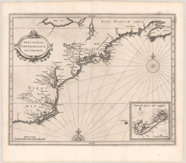
Auction 190, Lot 132
Subject: Colonial New England & Mid-Atlantic United States
Gerritsz/De Laet
Nova Anglia, Novum Belgium et Virginia, 1630
Size: 14 x 11 inches (35.6 x 27.9 cm)
Estimate: $6,000 - $7,500
A Critically Important Map in the Cartographic Evolution of North America
Unsold
Closed on 11/16/2022
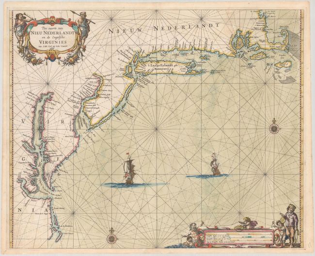
Auction 190, Lot 133
Subject: Colonial New England & Mid-Atlantic United States
Goos, Pieter
Pas Caerte van Nieu Nederlandt en de Engelsche Virginies Van Cabo Cod tot Cabo Canrick, 1666
Size: 20.9 x 16.9 inches (53.1 x 42.9 cm)
Estimate: $7,000 - $8,500
Goos' Gorgeous Chart of the Mid-Atlantic & New England
Unsold
Closed on 11/16/2022
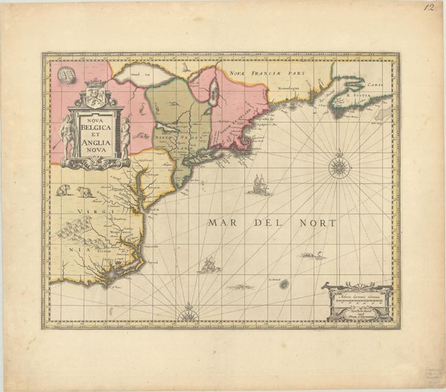
Auction 190, Lot 134
Subject: Colonial New England & Mid-Atlantic United States
Jansson/Valck & Schenk
Nova Belgica et Anglia Nova, 1694
Size: 19.5 x 15.1 inches (49.5 x 38.4 cm)
Estimate: $1,600 - $1,900
Jansson's Influential Map of the East Coast - Valck & Schenk Edition
Sold for: $1,200
Closed on 11/16/2022
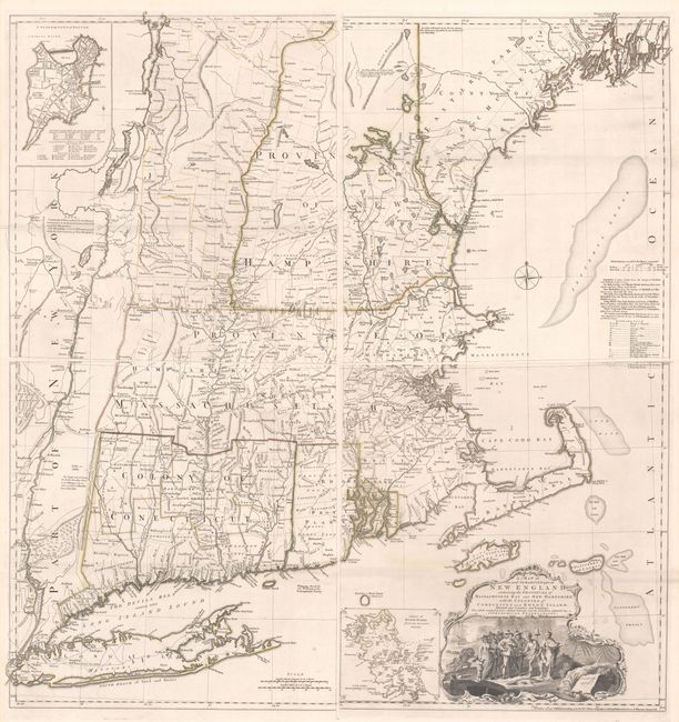
Auction 190, Lot 140
Subject: Colonial New England United States
Jefferys, Thomas
[On 4 Sheets] A Map of the Most Inhabited Part of New England, Containing the Provinces of Massachusets Bay and New Hampshire, with the Colonies of Conecticut and Rhode Island..., 1755
Size: 19.2 x 20.3 inches (48.8 x 51.6 cm)
Estimate: $7,000 - $8,500
Rare State of Jefferys' Influential Map of New England in Contemporary Color
Sold for: $3,250
Closed on 11/16/2022
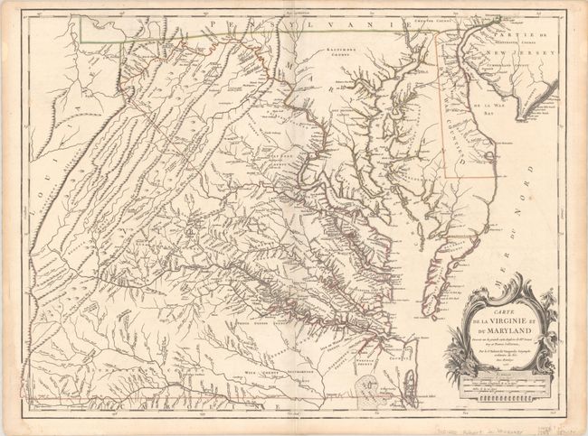
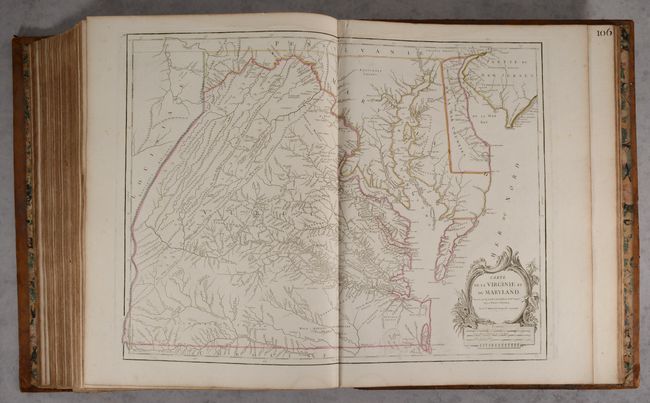
Auction 190, Lot 146
Subject: Colonial Mid-Atlantic United States
Robert de Vaugondy, Didier
Carte de la Virginie et du Maryland Dressee sur la Grande Carte Angloise de Mrs. Josue Fry et Pierre Jefferson..., 1755
Size: 25.4 x 19.1 inches (64.5 x 48.5 cm)
Estimate: $2,500 - $3,250
First State of Robert de Vaugondy's Essential Map of Virginia and Maryland
Sold for: $1,800
Closed on 11/16/2022
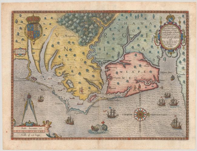
Auction 190, Lot 155
Subject: Colonial Southeast United States
White/De Bry
Americae Pars, nunc Virginia Dicta, Primum ab Anglis Inventa, Sumtibus Dn. Walteri Raleigh..., 1590
Size: 16.2 x 11.8 inches (41.1 x 30 cm)
Estimate: $15,000 - $18,000
The Earliest Collectible Map of Eastern North Carolina & Virginia
Sold for: $12,500
Closed on 11/16/2022
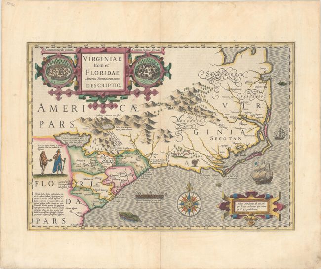
Auction 190, Lot 156
Subject: Colonial Southeast United States
Hondius, Jodocus
Virginiae Item et Floridae Americae Provinciarum, Nova Descriptio, 1628
Size: 19.1 x 13.5 inches (48.5 x 34.3 cm)
Estimate: $2,000 - $2,300
A Seminal Map of the Southeast and Early American Cartography - Full Contemporary Color
Sold for: $3,000
Closed on 11/16/2022
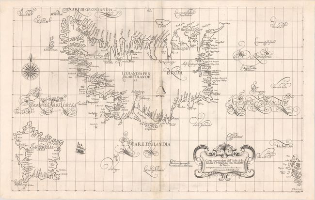
Auction 190, Lot 319
Subject: Iceland
Dudley, Robert (Sir)
Carta Particolare dell' Isole di Islandia e Frislandia, con l'Isolette di Fare..., 1661
Size: 29.9 x 19 inches (75.9 x 48.3 cm)
Estimate: $3,750 - $4,500
Rare Chart of Iceland and the Mythical Island of Frisland
Sold for: $3,250
Closed on 11/16/2022
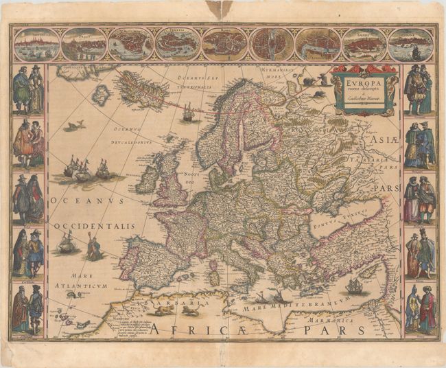
Auction 190, Lot 325
Subject: Europe
Blaeu, Willem
Europa Recens Descripta, 1635
Size: 21.9 x 16.1 inches (55.6 x 40.9 cm)
Estimate: $2,750 - $3,500
Blaeu's Carte-a-Figures Map of Europe in Full Contemporary Color
Sold for: $2,200
Closed on 11/16/2022
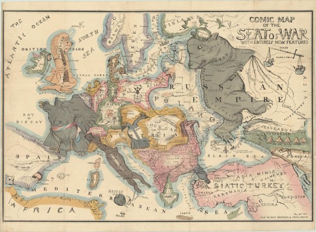
Auction 190, Lot 327
Subject: Europe
Comic Map of the Seat of War with Entirely New Features, 1854
Size: 26.8 x 18.3 inches (68.1 x 46.5 cm)
Estimate: $3,500 - $4,250
Earliest Serio-Comic War Map of Europe
Sold for: $1,750
Closed on 11/16/2022
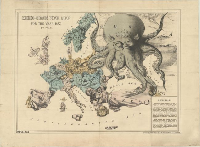
Auction 190, Lot 328
Subject: Europe
Rose, F. W.
Serio-Comic War Map for the Year 1877, 1877
Size: 22.4 x 16.7 inches (56.9 x 42.4 cm)
Estimate: $3,500 - $4,250
Very Rare First Edition, First State of Fred W. Rose's Iconic "Octopus" Map
Sold for: $1,750
Closed on 11/16/2022
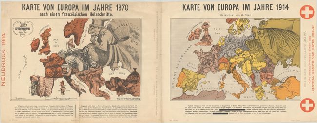
Auction 190, Lot 329
Subject: Europe, World War I
Karte von Europa im Jahre 1870 nach einem Franzosischen Holzschnitte / Karte von Europa im Jahre 1914, 1914
Size: 36.5 x 14 inches (92.7 x 35.6 cm)
Estimate: $1,400 - $1,700
Superb Pair of Satirical Maps Showing Political Changes in Europe from 1870-1914
Sold for: $700
Closed on 11/16/2022
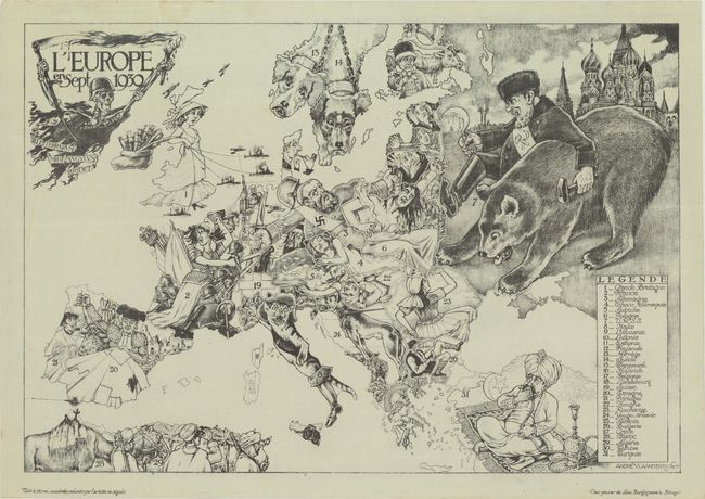
Auction 190, Lot 330
Subject: Europe, World War II
L'Europe en Sept 1939, 1939
Size: 32.7 x 22.5 inches (83.1 x 57.2 cm)
Estimate: $7,500 - $8,500
Rare Example of Limited Edition Serio-Comic Map Depicting Outset of World War II
Sold for: $3,250
Closed on 11/16/2022
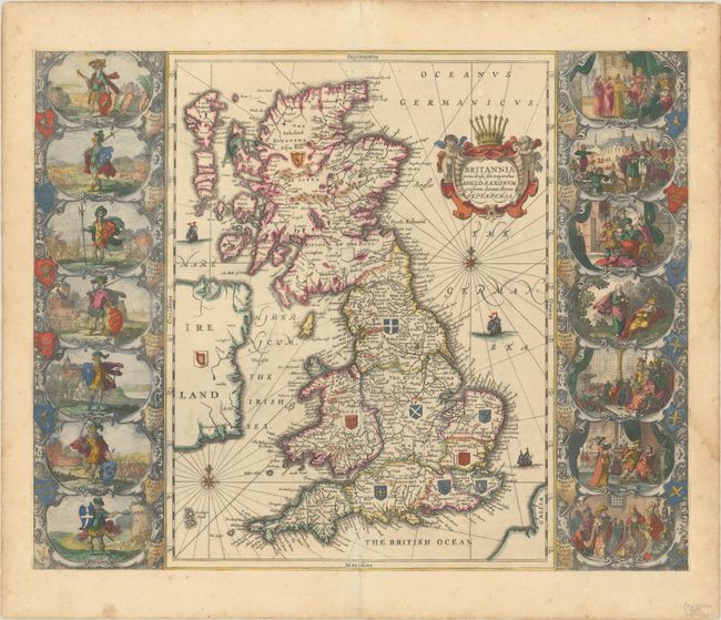
Auction 190, Lot 332
Subject: Britain
Jansson, Jan
Britannia Prout Divisa suit Temporibus Anglo-Saxonum, Praesertim Durante Illorum Heptarchia, 1684
Size: 20.8 x 16.6 inches (52.8 x 42.2 cm)
Estimate: $1,400 - $1,700
Jansson's Splendid Heptarchy Map
Unsold
Closed on 11/16/2022
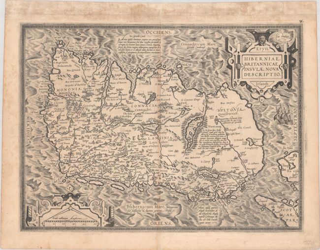
Auction 190, Lot 370
Subject: Ireland
Ortelius, Abraham
Eryn. Hiberniae, Britannicae Insulae, Nova Descriptio. Irlandt, 1573
Size: 19.1 x 14 inches (48.5 x 35.6 cm)
Estimate: $1,200 - $1,500
Ortelius' First Map of Ireland from First Edition Containing this Map
Sold for: $900
Closed on 11/16/2022
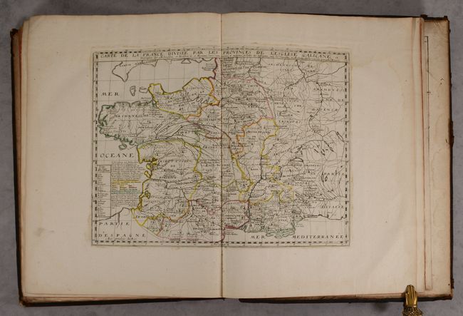
Auction 190, Lot 407
Subject: France & Belgium, Atlases
Sanson/Mariette
Cartes Geographiques des Gaules et de la France , 1707
Size: 16.4 x 21.3 inches (41.7 x 54.1 cm)
Estimate: $4,000 - $5,000
Elephant Folio Atlas with 121 Maps in Contemporary Color
Sold for: $2,500
Closed on 11/16/2022
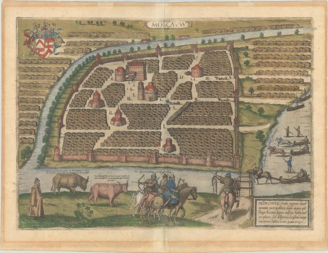
Auction 190, Lot 488
Subject: Moscow, Russia
Braun & Hogenberg
Moscauw, 1597
Size: 19.1 x 13.7 inches (48.5 x 34.8 cm)
Estimate: $2,750 - $3,500
Braun & Hogenberg's First Plan of Moscow in Full Contemporary Color
Sold for: $1,500
Closed on 11/16/2022
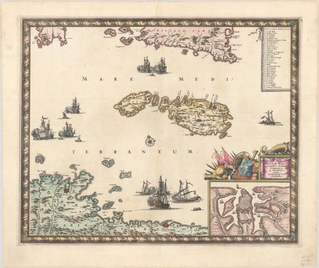
Auction 190, Lot 526
Subject: Malta
Wit, Frederick de
Insula Malta Accuratissime Delineata, Urbibus, et Fortalitiis, 1680
Size: 21.5 x 17.6 inches (54.6 x 44.7 cm)
Estimate: $1,200 - $1,500
One of the Most Decorative 17th Century Maps of Malta
Unsold
Closed on 11/16/2022
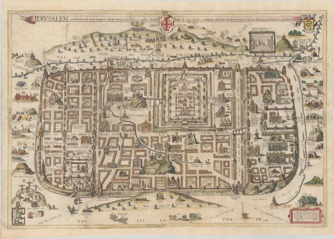
Auction 190, Lot 559
Subject: Jerusalem, Holy Land
Adrichom, Christian van
Ierusalem et Suburbia Eius, Sicut Tempore Christi Floruit, cum Locis, in Quibus Christus Passus Est: quae Religiose a Christianis Observata, Etia nu Venerationi Habetur Descripta, 1682
Size: 29.4 x 19.9 inches (74.7 x 50.5 cm)
Estimate: $2,000 - $2,300
Adrichom's Influential Bird's-Eye Plan of Jerusalem
Unsold
Closed on 11/16/2022
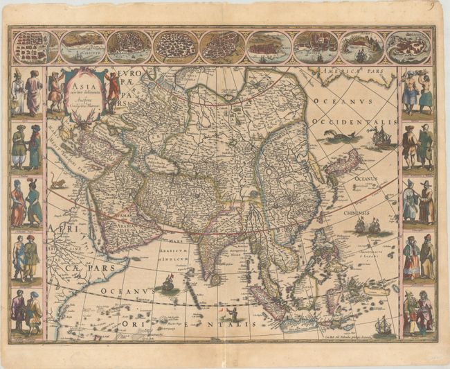
Auction 190, Lot 580
Subject: Asia
Blaeu, Willem
Asia Noviter Delineata, 1635
Size: 21.9 x 16.1 inches (55.6 x 40.9 cm)
Estimate: $3,250 - $4,000
Magnificent Carte-a-Figures Map of Asia in Full Contemporary Color
Sold for: $2,400
Closed on 11/16/2022
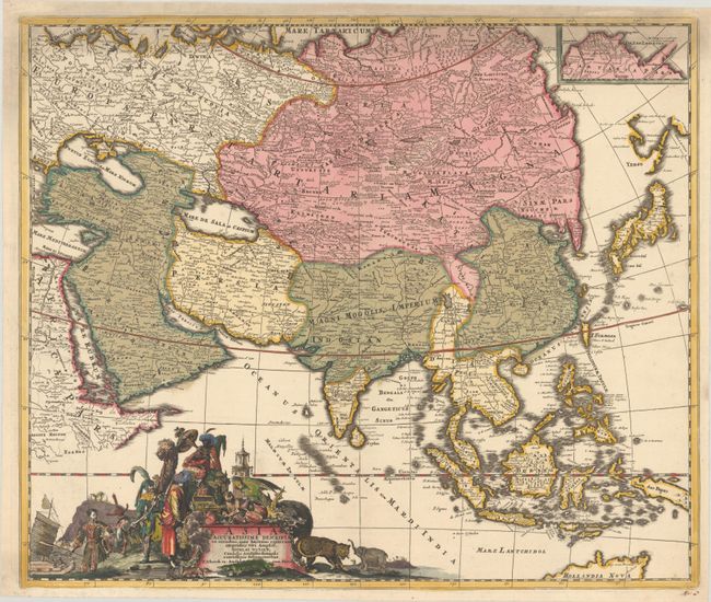
Auction 190, Lot 581
Subject: Asia
Witsen, Nicolaas
Asia Accuratissime Descripta ex Omnibus, quae Hactenus Extiterunt Imprimis Viri Ampliff..., 1705
Size: 23 x 19.3 inches (58.4 x 49 cm)
Estimate: $900 - $1,100
Shows Witsen's Important Updates that Influenced Other Dutch Cartographers
Sold for: $850
Closed on 11/16/2022
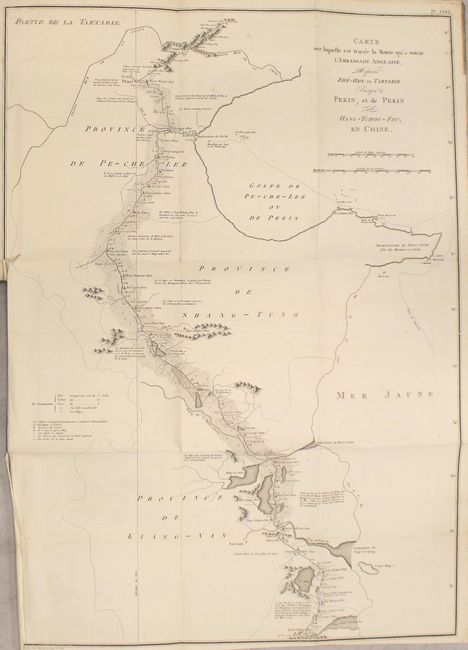
Auction 190, Lot 593
Subject: Exploration & Surveys, China
Voyage dans l'Interieur de la Chine, et en Tartarie, fait dans les Annees 1792, 1793 et 1794, par Lord Macartney..., 1804
Size: 8.5 x 11.4 inches (21.6 x 29 cm)
Estimate: $1,400 - $1,700
Atlas Volume to the Macartney Embassey to China Complete with 3 Maps and 38 Plates
Sold for: $1,100
Closed on 11/16/2022
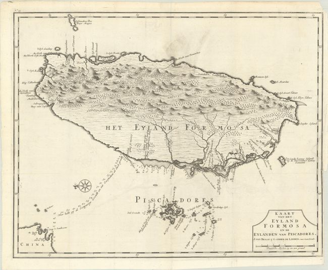
Auction 190, Lot 594
Subject: Taiwan
Valentyn, Francois
Kaart van het Eyland Formosa en de Eylanden van Piscadores, 1726
Size: 22 x 17.4 inches (55.9 x 44.2 cm)
Estimate: $3,500 - $4,250
Rare and Desirable Early Map of Taiwan
Sold for: $2,500
Closed on 11/16/2022
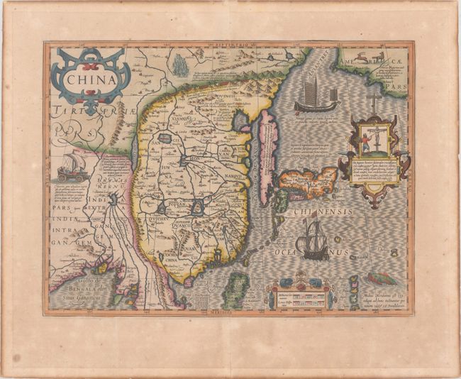
Auction 190, Lot 595
Subject: China, Korea & Japan
Mercator/Hondius
China, 1623
Size: 18.1 x 13.5 inches (46 x 34.3 cm)
Estimate: $2,750 - $3,500
Hondius' Map of China, Korea, and Japan
Sold for: $1,800
Closed on 11/16/2022
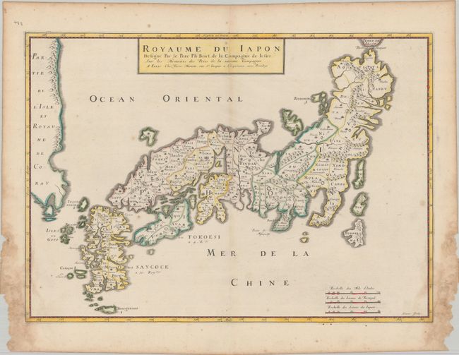
Auction 190, Lot 602
Subject: Japan & Korea
Briet, Philippe
Royaume du Iapon Designe par le Pere Ph: Briet, de la Compagnie de Iesus…, 1658
Size: 20.5 x 14.6 inches (52.1 x 37.1 cm)
Estimate: $1,500 - $1,800
Uncommon French Map of Japan
Unsold
Closed on 11/16/2022
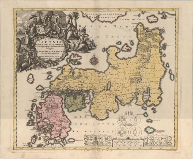
Auction 190, Lot 604
Subject: Japan
Seutter/Lotter
Regni Japoniae Nova Mappa Geographica, ex Indigenarum Observationibus Delineata ab Engelberto Kaempfero Recusa et Emendata, 1740
Size: 22.1 x 19.1 inches (56.1 x 48.5 cm)
Estimate: $1,200 - $1,500
Seutter's Decorative Map of Japan Based on Kaempfer
Sold for: $600
Closed on 11/16/2022
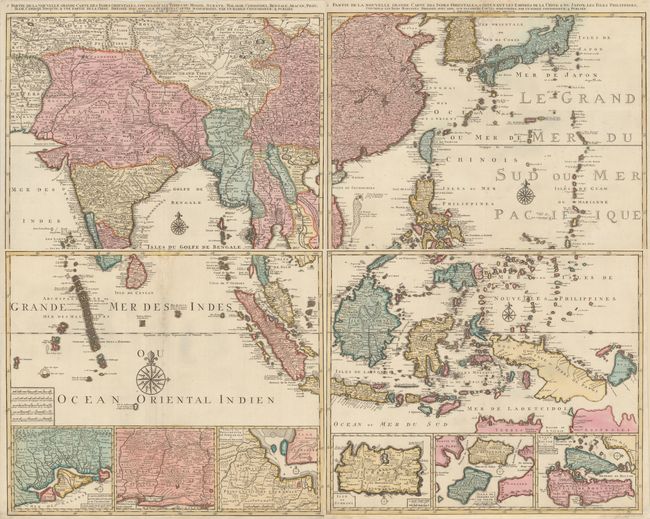
Auction 190, Lot 622
Subject: Southern & Southeast Asia
Elwe, Jan Barend
[On 4 Sheets] Partie de la Nouvelle Grande Carte des Indes Orientales..., 1792
Size: 23.9 x 19.9 inches (60.7 x 50.5 cm)
Estimate: $2,400 - $3,000
Superb Wall-Sized Map in Full Contemporary Color
Sold for: $1,800
Closed on 11/16/2022
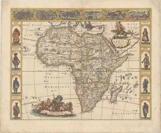
Auction 190, Lot 629
Subject: Africa
Wit, Frederick de
Nova Africa Descriptio, 1660
Size: 21.9 x 17.3 inches (55.6 x 43.9 cm)
Estimate: $2,400 - $3,000
De Wit's Uncommon Carte-a-Figures Map of Africa
Unsold
Closed on 11/16/2022
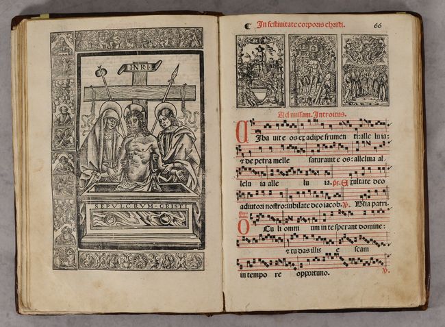
Auction 190, Lot 698
Subject: Music
Graduale Iuxta Morem Sacrosancte Ecclesie Romane..., 1551
Size: 11.5 x 17.3 inches (29.2 x 43.9 cm)
Estimate: $6,000 - $7,500
Superb Crown Folio Gradual with Manuscript and Printed Music
Unsold
Closed on 11/16/2022
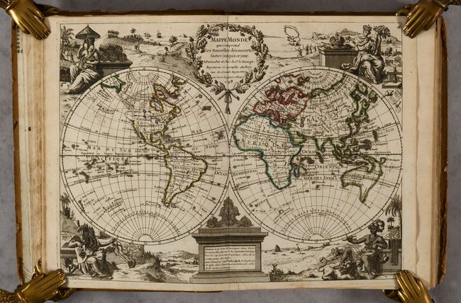
Auction 190, Lot 710
Subject: Atlases
Jaillot, Alexis-Hubert
Tablettes Geographiques, ou Recueil des Principales Cartes Generales et Particulieres..., 1695
Size: 5 x 7.6 inches (12.7 x 19.3 cm)
Estimate: $1,100 - $1,500
Rare Small Atlas Known in Only 3 Other Examples
Sold for: $1,500
Closed on 11/16/2022
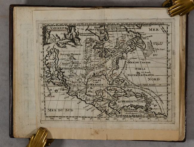
Auction 190, Lot 712
Subject: Atlases
Le Rouge, George Louis
Atlas Nouveau Portatif a l'Usage des Militaires, et du Voyageur Contenant 91 Cartes Dressees sur les Nouvelles Observations, 1756
Size: 7.5 x 9.6 inches (19.1 x 24.4 cm)
Estimate: $2,200 - $2,500
Charming Mid-Eighteenth Century French Atlas with 90 Maps
Sold for: $1,600
Closed on 11/16/2022
Auction 190, Lot 714
Subject: Atlases
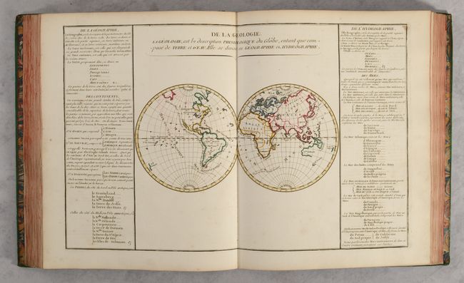
Buy de Mornas, Claude
[4 Volumes] Atlas Methodique et Elementaire de Geographie et d'Histoire, 1761-62
Size: 11.1 x 13.4 inches (28.2 x 34 cm)
Estimate: $3,500 - $4,500
Contains 135 Double-Page Maps in Contemporary Color
Sold for: $2,100
Closed on 11/16/2022
Auction 190, Lot 716
Subject: Atlases
Robert de Vaugondy/Delamarche
Atlas Universel, 1788
Size: 18 x 22.5 inches (45.7 x 57.2 cm)
Estimate: $9,000 - $11,000
Complete Elephant Folio Atlas in Contemporary Color with 112 Maps
Sold for: $6,500
Closed on 11/16/2022
54 lots
Page 1 of 2