Subject: Colonial Eastern United States, Louisiana Territory
Period: 1745 (dated)
Publication:
Color: Hand Color
Size:
25.4 x 19.1 inches
64.5 x 48.5 cm
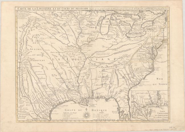
This is the updated version of Delisle's influential map of the French possession of Louisiana that drew together the cartographic work of the previous half century and had a tremendous impact on the history of cartography. When originally published in 1718, it was the first detailed map of the Gulf region and the Mississippi, and the first to show the explorations of De Soto, Cavelier, Tonty, Moscoso, and Denis. The map was designed for the political purpose of invalidating the English claims west of the Appalachian Mountains and laid claim to Carolina by the French, which provoked an angry English response. However, it is the cartography of the Mississippi Valley for which the map is notable today. The name Texas made its first appearance in print on this map, with the legendary Mission de los Teijas, established in 1716. The notation of Indiens errans et anthrophages along the Gulf Coast warns of cannibals. An inset of the Mississippi Delta and Mobile Bay fills the lower right corner. This is the Buache edition, which is a reissue of the second state of the original plate, showing the settlement of New Orleans, founded in 1718.
References: Tooley (America) p.22, #46; cf. Cumming (SE) #208; cf. Wheat (TMW) #99; cf. Martin & Martin #19.
Condition: A
A crisp impression on watermarked paper with somewhat faded contemporary outline color. There are a couple archivally repaired edge tears and light soiling that is mostly confined to the blank margins.