Subject: Europe
Period: 1854 (dated)
Publication:
Color: Hand Color
Size:
26.8 x 18.3 inches
68.1 x 46.5 cm
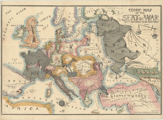
Satirical maps have their roots in the 16th century, but gained popularity in the nineteenth century with the political caricature map. This map is considered the earliest political cartoon map of Europe, and it proved highly influential, inspiring many more "serio-comic" war maps of the continent, including those by Fred W. Rose and Paul Hadol. It focuses on the political situation at the time of the Crimean War.
The major players in the conflict are boldly caricatured, and the map is filled with scores of interesting and humorous symbols. The Russian Bear, wearing the Imperial crown labeled Despotism, brandishes a cat-o-nine-tails whip as he marches towards Asia while looking over his shoulder to Europe. The bear’s right foot forms the Crimean peninsula where the French and English fleets gather to clip the bear’s claws. The Caucasus appear as a series of cork-exploding volcanoes (Cork As Us Mountains), a reference to the perennial political unrest in the region. In Europe, the Balkans appear in the form of a Turkey wearing a fez and clutching a bottle of port labeled Constantinople and "Sublime Port" to signify the importance of the port city as a passage-way to the Black Sea. France appears as the Imperial Eagle (a reference to Emperor Napoleon III) girded in a ceremonial sash. The British Isles take the form of an armed lion with Ireland as a ragged peasant figure. An English fleet is shown entering the Gulf of Finland, a reference to the British Prime Minister's use of gunboat diplomacy. Italy takes on the form of a running dog, wearing the papal crown. The double-headed eagle of Austria, looks both east and west, a reference to Austrian neutrality and clumsy attempts at diplomacy shown in a variety of notes tucked under the eagle's wings and in its beaks. The other European countries form a variety of comical figures. The scale of miles is formed by a sword and balance scale depicting Russia on one side and The Allied Powers on the other.
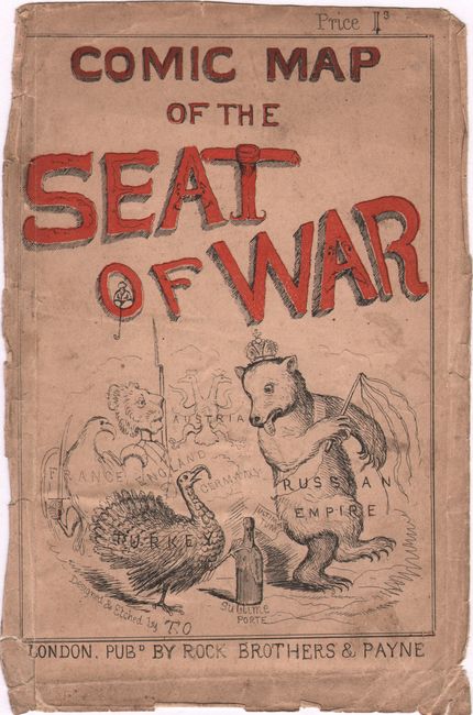
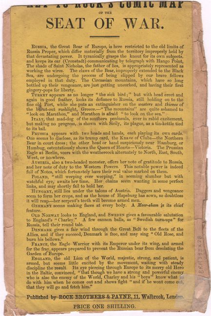
It would take a good deal of study to understand the totality of this map's political and satirical nuances. This example includes the original pictorial heavy paper cover with explanatory text on verso to aid in deciphering the map. The hand-colored cover repeats several of the characters from the map, such as the bear and the turkey, and shows the price as 1 shilling. Published by Rock Brothers & Payne in London, May 30, 1854.
The author of the map is Thomas Onwhyn, whose initials appear in Turkey, just north of Cyprus. Onwhyn (c. 1811-86) was an English artist, cartoonist and engraver. He was born in London as the son of Joseph, a bookseller, publisher and printer, and Frances, an artist. Onwhyn created illustrations for satirical journals, novels, and other publications, including a pirated edition of The Pickwick Papers under the name "Samuel Weller."
This map is quite scarce, particularly accompanied by the original cover.
References: Baynton-Williams (Curious) pp. 158-59; Rumsey #10618.
Condition: B+
Contemporary color on a bright sheet, issued folding and now flattened and professionally backed in archival tissue to repair some short separations and a few tiny holes along the folds, as well as a 1" tear at right. There is a minute amount of image replaced in facsimile at fold intersections, and light soiling in the image. The map is detached from the cover, which is soiled with chips and tears along the edges. The text on verso is trimmed at top with loss of part of the title, and a chip at bottom has been repaired with archival tissue.